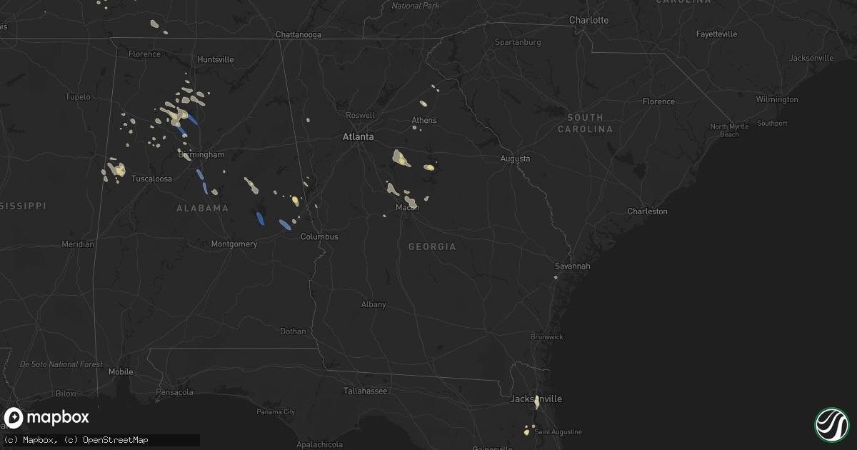
Hail Map in Georgia on August 3, 2023
Get this storm
August 3 map
$229
one time, instant access
Download today. No call, no setup
Keep the $229
Bought the map and want the full workflow? Apply the entire $229 to a subscription within 7 days. None of it is wasted.
Every map, not just this one
This buys you this map. Subscription and you get every map we run, in the markets you choose from a few cities to whole states to nationwide. Plus real-time alerts the moment a storm fires.
Contact data
Name, contact info, occupancy, even credit band for addresses in the footprint. You go from where it hit to who to call.
Become the source they trust
Unlimited branding weather history reports on demand. You already have the documented answer ready for the property owner, and you are the one who showed up with it.
Property data and RoofTrace estimates
Pull up any address you have got, its value and the exact code rules for that jurisdiction, straight from One Click Code. Then RoofTrace estimates the squares, pitch, and roof value, priced the way you price.
Storm reports in Georgia
Georgia
| Date | Description |
|---|---|
| 08/03/20236:58 PM CDT | Tree down on brantley rd and hwy 352. |
| 08/03/20236:42 PM CDT | Tree down on ga hwy 80 at turkey creek bridge. |
| 08/03/20236:37 PM CDT | Tree down at ga18 and n. Magnolia st. |
| 08/03/20236:34 PM CDT | Two reports of trees down on wagon wheel rd between ga80 and bullard rd. |
| 08/03/20236:30 PM CDT | Tree down near bullard rd and noah thomas rd. |
| 08/03/20236:30 PM CDT | Tree down near bullard rd at i-16. |
| 08/03/20236:29 PM CDT | Tree down on bullard rd near flat creek bridge. |
| 08/03/20236:25 PM CDT | Power pole down at highway 80 and lawdon road. |
| 08/03/20236:19 PM CDT | Several trees down near old gordon rd and kaolin-heights rd. |
| 08/03/20236:15 PM CDT | Reports of several trees down on union church rd in the area around walton rd. |
| 08/03/20235:59 PM CDT | Tree down blocking roadway on hwy 22 at nelson rd nw. |
| 08/03/20235:30 PM CDT | A tree was reported down near the intersection of may road and milledgeville road. |
| 08/03/20235:30 PM CDT | A tree was reported down on jackson rd se. |
| 08/03/20235:28 PM CDT | Powerline down near the intersection of old alabama rd and jeff davis rd. |
| 08/03/20235:20 PM CDT | Tree down on powerline. |
| 08/03/20235:20 PM CDT | Tree down on powerline. |
| 08/03/20235:15 PM CDT | A tree was blown down on the 1300 block of barnesville rd. |
| 08/03/20235:07 PM CDT | A nnw-sse swath of trees were also blown down on the e side of griffin as a strong line of storms swept through the area. Locations incl brawner st... Grantland rd... M |
| 08/03/20235:01 PM CDT | A n-s swath of trees blown down on the west side of griffin as a line of storms swept through the area. Locations incl vineyard rd... Fayetteville rd... Cardinal dr... |
| 08/03/20235:00 PM CDT | Trees and power lines were downed at oconee springs park. |
| 08/03/20235:00 PM CDT | A tree was blown down on wards chapel rd. |
| 08/03/20234:55 PM CDT | A tree was downed on river bend drive. |
| 08/03/20234:53 PM CDT | Several trees and powerlines down around the city of lagrange....ridley/mitchell ave.... Keener/hill st.... Cherry/douglas st. |
| 08/03/20234:45 PM CDT | Several trees and power lines were reported down in the vicinity of jackson lake... Including on jackson lake rd... Alcovy n rd... And county line rd. |
| 08/03/20234:42 PM CDT | Numerous trees blown down around senoia and the surrounding areas in se coweta county. Heavily impacted locations include gordon rd... Dead oak rd... And along hwys 85 |
| 08/03/20234:25 PM CDT | Several trees blown down in the area between madras and palmetto in ne coweta county. Locations incl i-85 at exit 51... Sloan rd and happy valley cir... And the 4700 bl |
| 08/03/20234:24 PM CDT | Tree down on powerline blocking roadway. |
| 08/03/20234:18 PM CDT | Over a dozen trees blown down in a large swath north and west of newnan. Heavily impacted areas include welcome rd... Mt carmel rd... Smith rd and roscoe rd. |
| 08/03/20234:15 PM CDT | Numerous trees and powerlines down along roadways in the newnan area. |
| 08/03/20234:07 PM CDT | Tree reported down on a powerline over the roadway near the intersection of poplar st and old forrester rd. |
| 08/03/20233:53 PM CDT | Multiple trees and powerlines down near mount zion and west of carrollton. |
| 08/03/20233:47 PM CDT | A tree was downed on bisson woods drive. |
| 08/03/20233:45 PM CDT | A tree was reported down on clouds creek road. |
| 08/03/20233:45 PM CDT | A tree was reported down on lexington carlton road. |
| 08/03/20233:40 PM CDT | The emergency manager reported a down tree at indian trial drive and hiram douglasville highway. |
| 08/03/20233:40 PM CDT | A tree was downed on melton road. |
| 08/03/20233:37 PM CDT | Tree/powerline down along campbellton st. |
| 08/03/20233:37 PM CDT | Tree/powerline down near the intersection of chapel hill rd and chapel valley dr. |
| 08/03/20233:37 PM CDT | Multiple trees down around tallapoosa and buchanan. |
| 08/03/20233:31 PM CDT | The emergency manager reported a tree down in the roadway at brownsville road and sweetwater circle. |
| 08/03/20233:30 PM CDT | The emergency manager reported a tree down on powerlines at the intersection of nebo road and swan drive. |
| 08/03/20233:20 PM CDT | Tree down along roadway. |
| 08/03/20233:10 PM CDT | Tree down in roadway on juhan rd and rockbridge rd. |
| 08/03/20233:09 PM CDT | The emergency manager reported downed powerlines at the intersection of colbert road and crowe road. |
| 08/03/20233:05 PM CDT | Tree down in roadway on somerset rd. |
| 08/03/20233:00 PM CDT | One tree down... Knocking down powerlines southwest of rockmart. |
| 08/03/20233:00 PM CDT | Report of tree downed on a vehicle along or near hwy 17. |
| 08/03/20232:57 PM CDT | The emergency manager reported a down stop sign at the intersection of highway 101 n and gold mine road. |
| 08/03/20232:45 PM CDT | Tree down on the roadway near the intersection or ridgeway rd and mintz rd. |
| 08/03/20232:45 PM CDT | Tree down on a powerline at the intersection of hwy 198 and martin bridge rd. |
| 08/03/20232:40 PM CDT | Powerlines reported down near the intersection of hwy 164 and hwy 98. |
| 08/03/20232:40 PM CDT | Tree down in roadway on old peachtree rd. |
| 08/02/20237:22 PM CDT | Tree downed at residence near edsel senn rd. |
| 08/02/20237:10 PM CDT | Tree downed near residence in south part of dublin. |
All States Impacted by Hail Map on August 3, 2023
Cities Impacted by Hail Map on August 3, 2023
- Saint Johns, FL
- Yulee, FL
- Glendive, MT
- Jacksonville, FL
- Kinross, MI
- Saint Augustine, FL
- Sault Sainte Marie, MI
- McKenzie, TN
- Woodbine, GA
- Hastings, FL
- Callahan, FL
- Clermont, FL
- Hoxie, KS
- Morland, KS
- Jasper, AL
- Empire, AL
- Bremen, AL
- Cullman, AL
- Hanceville, AL
- Hayden, AL
- Warrior, AL
- Cordova, AL
- Dora, AL
- Sumiton, AL
- Pelham, AL
- Helena, AL
- Alabaster, AL
- Calera, AL
- Commerce City, CO
- Denver, CO
- Thornton, CO
- Brighton, CO
- Cheyenne, WY
- Aurora, CO
- Elkton, MI
- Sebewaing, MI
- Pigeon, MI
- Owendale, MI
- Bay Port, MI
- Saranac Lake, NY
- Tupper Lake, NY
- Lake Placid, NY
- Ray Brook, NY
- Gagetown, MI
- Cass City, MI
- Jemison, AL
- Grover, CO
- Laporte, CO
- Bellvue, CO
- Watkins, CO
- Bennett, CO
- Elizabeth, CO
- Kiowa, CO
- Elbert, CO
- Calhan, CO
- Penrose, CO
- Pueblo, CO
- Auburn, AL
- Waverly, AL
- Auburn University, AL
- Alexander City, AL
- Tallassee, AL
- Dadeville, AL
- Colorado Springs, CO
- Ramah, CO
- Avondale, CO
- Drake, CO
- Loveland, CO
- Fort Collins, CO
- Cedar, MI
- Traverse City, MI
- Winter Garden, FL
- Orlando, FL
- Columbus, MS
- Mulga, AL
- Pleasant Grove, AL
- Bessemer, AL
- Bunnell, FL
- Crescent City, FL
- Danielsville, GA
- Commerce, GA
- Hull, GA
- Macon, GA
- Fairview, MT
- Scranton, ND
- Bishop, GA
- Saint Regis Falls, NY
- Green Cove Springs, FL
- Manitowoc, WI
- Two Rivers, WI
- Prairie City, OR
- Arley, AL
- Mishicot, WI
- Denmark, WI
- Green Bay, WI
- Luxemburg, WI
- Keystone Heights, FL
- Fallon, MT
- Woodland, MS
- Ethelsville, AL
- Reform, AL
- Double Springs, AL
- Covington, GA
- Mansfield, GA
- Monticello, GA
- Newborn, GA
- Shady Dale, GA
- New Franken, WI
- Kalkaska, MI
- Fayette, AL
- Kennedy, AL
- Oneida, WI
- De Pere, WI
- Seymour, WI
- Kingsland, GA
- Brunswick, GA
- Casco, WI
- Logan, AL
- Berry, AL
- Carnesville, GA
- Hilliard, FL
- Au Gres, MI
- Canon, GA
- Menominee, MI
- Empire, MI
- Bloomingdale, NY
- Stephenson, MI
- Nauvoo, AL
- Carbon Hill, AL
- Quinton, AL
- Sulligent, AL
- Frankfort, MI
- Vinemont, AL
- Guin, AL
- Beaverton, AL
- Red Feather Lakes, CO
- Rockmart, GA
- Cedartown, GA
- Cedarbluff, MS
- West Point, MS
- Baileyton, AL
- Eva, AL
- Little Suamico, WI
- Algoma, WI
- Belfield, ND
- Medora, ND
- Crane Hill, AL
- Willard, UT
- Brigham City, UT
- Brockway, MT
- Maple City, MI
- Lake Ann, MI
- Harpersville, AL
- Suamico, WI
- Kewaunee, WI
- Bryceville, FL
- Abrams, WI
- Oconto, WI
- Caledonia, MS
- Palatka, FL
- Winfield, AL
- Windermere, FL
- Oakman, AL
- Grouse Creek, UT
- Watkinsville, GA
- Bogart, GA
- Egg Harbor, WI
- Sturgeon Bay, WI
- Pomona Park, FL
- Alexander, ND
- Eatonton, GA
- Franktown, CO
- Georgetown, FL
- Folkston, GA
- Hartselle, AL
- Houston, AL
- Addison, AL
- Fowler, CO
- Haleyville, AL
- Franklin, GA
- Lagrange, GA
- Carrollton, AL
- Decatur, AL
- San Mateo, FL
- Seville, FL
- Starkville, MS
- Glen Arbor, MI
- Falkville, AL
- Adamsville, AL
- Kiel, WI
- New Holstein, WI
- Simla, CO
- Agate, CO
- Ludington, MI
- Free Soil, MI
- Timnath, CO
- Windsor, CO
- Clifford, MI
- Brown City, MI
- Marlette, MI
- North Branch, MI
- Sedan, NM
- Severance, CO
- Greeley, CO
- Eaton, CO
- Yoder, CO
- Rush, CO
- Texline, TX
- Lucerne, CO
- Kersey, CO
- Crawford, NE
- Whitney, NE
- Chadron, NE
- Central Square, NY
- Pennellville, NY
- Brewerton, NY
- Mallory, NY
- West Monroe, NY
- Constantia, NY
- Oelrichs, SD
- Smithwick, SD
- Oral, SD
- Pine Ridge, SD
- Wheatland, WY
- Yoder, WY
- Fort Laramie, WY
- New Raymer, CO
- Seibert, CO
- Flagler, CO
- Boone, CO
- Vona, CO
- Stratton, CO
- Kit Carson, CO
- Cheyenne Wells, CO
- Burlington, CO
- Bethune, CO
- Kanorado, KS
- Arapahoe, CO
- Haxtun, CO
- Paoli, CO
- Holyoke, CO
- Sterling, CO
- Iliff, CO
- Padroni, CO
- Crook, CO
- Fleming, CO
- American Fork, UT
- Riverton, UT
- Alpine, UT
- Lehi, UT
- Draper, UT
- South Jordan, UT
- Herriman, UT
- Bingham Canyon, UT
- West Jordan, UT
- Sandy, UT
- Salt Lake City, UT
- Midvale, UT
- Cedar Valley, UT
- Hay Springs, NE
- Weskan, KS
- Tribune, KS
- Sharon Springs, KS
- Wallace, KS
- Leoti, KS
- Lamar, CO
- Holly, CO
- Marienthal, KS
- Winona, KS
- Monument, KS
- Oakley, KS
- Grinnell, KS
- Healy, KS
- Scott City, KS
- Gove, KS
- Amherst, CO
- Poplar, MT
- Pierre, SD
- Clayton, NM
- Plover, WI
- Stevens Point, WI
- Gladstone, ND
- Dickinson, ND
- Parker, CO
- Nunn, CO
- Olney Springs, CO
- Ripton, VT
- Fife Lake, MI
- Marsland, NE
- Kaukauna, WI
- Wrightstown, WI
- Williamsburg, MI
- Culbertson, MT
- Lowville, NY
- Constableville, NY
- Forsyth, GA
- Neenah, WI
- Hastings, NY
- Phoenix, NY
- Williamstown, NY
- Parish, NY
- Fulton, NY
- Lafayette, AL
- Kimball, NE
- Dix, NE
- Milledgeville, GA
- Gordon, GA
- Atwood, CO
- Livermore, CO
- Arriba, CO
- Clay, NY
- Bernhards Bay, NY
- Fairfield, ND
- Camden, NY
- Redfield, NY
- Elkhart Lake, WI
- Lance Creek, WY
- Newton, WI
- Mexico, NY
- Augusta, WI
- Fairchild, WI
- Strasburg, CO
- Henderson, CO
- Dupont, CO
- Middlebury, VT
- Oshkosh, WI
- Rapid City, MI
- Akron, CO
- Broadalbin, NY
- Middle Grove, NY
- Galway, NY
- Aliceville, AL
- Alden, MI
- Brooksville, MS
- Gurley, NE
- Eads, CO
- Burns, WY
- Carpenter, WY
- Pine Bluffs, WY
- Van Dyne, WI
- Fond Du Lac, WI
- Merino, CO
- Newcastle, WY
- Sidney, NE
- Lodgepole, NE
- Upton, WY
- Little Falls, NY
- Salisbury Center, NY
- Cedarville, MI
- Stoneham, CO
- Northville, NY
- Hadley, NY
- Manzanola, CO
- Edgemont, SD
- Whitelaw, WI
- Hot Springs, SD
- Kingston, MI
- Elk Rapids, MI
- Kewadin, MI
- White Plains, GA
- Juliette, GA
- Hessel, MI
- Rudyard, MI
- Orchard, CO
- Mountain Home Afb, ID
- Mountain Home, ID
- Saint Cloud, WI
- Brillion, WI
- Valders, WI
- Chilton, WI
- Reedsville, WI
- Collins, WI
- Daviston, AL
- Gray, GA
- Goodwater, AL
- Shelby, AL
- Clanton, AL
- Musella, GA
- Roberta, GA
- Knoxville, GA
- Bushnell, NE
- Pine Mountain, GA
- West Point, GA
- Unionville, MI
- Deford, MI
- Florence, CO
- Rockvale, CO
- Silverwood, MI
- Opelika, AL
- Shelby, MI
- New Era, MI
- Mears, MI
- Hasty, CO
- Briggsdale, CO
- Lanett, AL
- East Prairie, MO
- Hickman, KY
- Cusseta, AL
- Fort Morgan, CO
- Byers, CO
- Yuma, CO
- Laramie, WY
- Kellyton, AL
- Hilbert, WI
- Oswego, NY
- Newbern, TN
- Trenton, TN
- Dyer, TN
- Alliance, NE
- Jefferson City, MO
- Arlington, KY
- Clinton, KY
- Blackburn, MO
- Alma, MO
- Saltillo, TN
- Sheridan Lake, CO
- Linden, TN
- Patton, MO
- Dresden, TN
- Huntingdon, TN
- Gleason, TN
- Trezevant, TN
- Greenfield, TN
- Granada, CO
- Garden City, KS
- Lakin, KS
- Ulysses, KS
- Rutherford, TN
- Humboldt, TN
- Wray, CO
- Syracuse, KS
- Bonnots Mill, MO
- Marble Hill, MO
- Champion, NE
- Fulton, KY
- Wildersville, TN
- Lisco, NE
- Sedgwick, CO
- Selden, KS
- Dresden, KS
- Caro, MI
- Stratford, TX
- Lewellen, NE
- Westport, TN
- Woodrow, CO
- McDonald, KS
- Bird City, KS
- Atwood, KS
- Bardwell, KY
- Higginsville, MO
- Corder, MO
- Macon, MS
- Hermann, MO
- Rhineland, MO
- Goodwell, OK
- Martin, GA
- Obion, TN
- Cleveland, NY
- Satanta, KS
- Sweet Springs, MO
- Ault, CO
- Cicero, NY
- Matheson, CO
- Bloomfield, MO
- Essex, MO
- Bertrand, MO
- Ellsworth, KS
- Charleston, MO
- Bell City, MO
- Sikeston, MO
- Canalou, MO
- New Madrid, MO
- Matthews, MO
- Saint Francis, KS
- Arthur, NE
- Bradford, TN
- Ellsworth, NE
- Sullivan, MO
- Sublette, KS
- Hornbeak, TN
- Portageville, MO
- Ridgely, TN
- Union City, TN
- Tiptonville, TN
- Troy, TN
- Remsen, NY
- Ovid, CO
- Lorraine, KS
- Parma, MO
- Lexington, MO
- Cedar Grove, TN
- Harrison, NE
- Richmond Hill, GA
- Marquand, MO
- Marston, MO
- Oran, MO
- Advance, MO
- Whitewater, MO
- Chaffee, MO
- Marshall, MO
- Holcomb, KS
- Townley, AL
- Bernie, MO
- Fancy Farm, KY
- Danville, AL
- Broadwater, NE
- Holladay, TN
- Parsons, TN
- Martin, TN
- South Fulton, TN
- Kenton, TN
- Boaz, AL
- Horton, AL
- Jackson, TN
- Hemingford, NE
- Medina, TN
- Oakfield, TN
- Sharon, TN
- Reagan, TN
- Enville, TN
- Lavonia, GA
- Catron, MO
- Oshkosh, NE
- Rives, TN
- Pierceville, KS
- Westernville, NY
- Boonville, NY
- Yuma, TN
- Trimble, TN
- Sardis, TN
- Scotts Hill, TN
- Wilson, KS
- Dexter, MO
- Fredericktown, MO
- Ironton, MO
- Norborne, MO
- Lilbourn, MO
- Waverly, MO
- Malta Bend, MO
- Brownell, KS
- Ransom, KS
- McCracken, KS
- Nelson, MO
- Ingalls, KS
- Denmark, TN
- Montezuma, KS
- Loretto, TN
- Five Points, TN
- Leoma, TN
- Copeland, KS
- Kanopolis, KS
- Ness City, KS
- Vanduser, MO
- Eldorado, WI
- Whiteville, TN
- Kendall, KS
- Boise City, OK
- Zalma, MO
- Sturdivant, MO
- Russell, KS
- Greenville, MO
- Blackwater, MO
- Lavinia, TN
- Bazine, KS
- Des Arc, MO
- Annapolis, MO
- Bells, TN
- Gadsden, TN
- Glenallen, MO
- Arcadia, MO
- Silva, MO
- Ellis, KS
- Hughesville, MO
- Houstonia, MO
- Eckley, CO
- Linn, MO
- Hardin, MO
- Steelville, MO
- Cherryville, MO
- Milan, TN
- Lawrenceburg, TN
- Westpoint, TN


