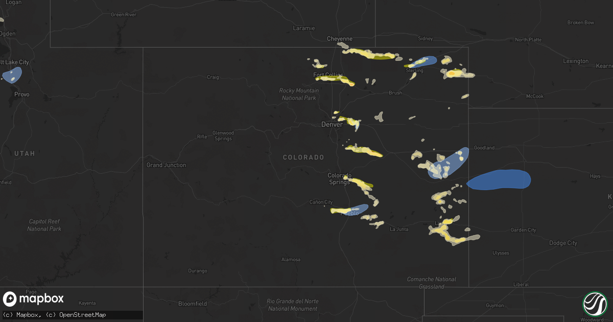
Hail Map in Colorado on August 3, 2023
Get this storm
August 3 map
$229
one time, instant access
Download today. No call, no setup
Keep the $229
Bought the map and want the full workflow? Apply the entire $229 to a subscription within 7 days. None of it is wasted.
Every map, not just this one
This buys you this map. Subscription and you get every map we run, in the markets you choose from a few cities to whole states to nationwide. Plus real-time alerts the moment a storm fires.
Contact data
Name, contact info, occupancy, even credit band for addresses in the footprint. You go from where it hit to who to call.
Become the source they trust
Unlimited branding weather history reports on demand. You already have the documented answer ready for the property owner, and you are the one who showed up with it.
Property data and RoofTrace estimates
Pull up any address you have got, its value and the exact code rules for that jurisdiction, straight from One Click Code. Then RoofTrace estimates the squares, pitch, and roof value, priced the way you price.
Storm reports in Colorado
Colorado
| Date | Description |
|---|---|
| 08/03/20236:55 PM CDT | Awos station k1ow 2 nw pawnee buttes. |
| 08/03/20236:55 PM CDT | A local report indicates 1.00 inch wind near 4 S Fort Collins |
| 08/03/20236:50 PM CDT | Report from mping: half dollar |
| 08/03/20236:43 PM CDT | Report from mping: quarter |
| 08/03/20236:42 PM CDT | Report from mping: quarter |
| 08/03/20236:41 PM CDT | A local report indicates 1.50 inch wind near 5 N Matheson |
| 08/03/20236:15 PM CDT | A local report indicates 67 MPH wind near 5 NE Blende |
| 08/03/20236:13 PM CDT | Measured shortly after a 58 mph gust at the same station. |
| 08/03/20236:13 PM CDT | Measured shortly after a |
| 08/03/20236:05 PM CDT | A local report indicates 1.20 inch wind near 11 NNW Simla |
| 08/03/20235:28 PM CDT | A local report indicates 66 MPH wind near Bennett |
| 08/03/20234:45 PM CDT | A local report indicates 1.00 inch wind near Thornton |
| 08/03/20234:41 PM CDT | Hail size ranged from nickel to quarter size. |
| 08/03/20234:33 PM CDT | A local report indicates 1.00 inch wind near Thornton |
| 08/03/20234:29 PM CDT | Report from mping: half dollar |
| 08/02/202310:13 PM CDT | A local report indicates 69 MPH wind near 4 S Burlington |
| 08/02/202310:12 PM CDT | A local report indicates 59 MPH wind near 4 S Burlington |
| 08/02/20239:57 PM CDT | Home site measured a max gust of 60.6 mph. |
| 08/02/20239:10 PM CDT | Trained spotter reports weather station measured 65 mph thunderstorm wind gust. Time estimated. |
| 08/02/20238:56 PM CDT | A local report indicates 60 MPH wind near Seibert |
| 08/02/20238:50 PM CDT | A local report indicates 68 MPH wind near Iliff |
| 08/02/20238:43 PM CDT | A local report indicates 1.00 inch wind near Iliff |
| 08/02/20238:10 PM CDT | A local report indicates 1.75 inch wind near Kersey |
| 08/02/20238:01 PM CDT | Corrects previous hail report from kersey. |
| 08/02/20237:44 PM CDT | A local report indicates 1.25 inch wind near 2 ENE Greeley |
| 08/02/20237:41 PM CDT | A local report indicates 1.00 inch wind near 1 SW Lucerne |
| 08/02/20237:39 PM CDT | A local report indicates 1.00 inch wind near 2 NE Greeley |
| 08/02/20237:36 PM CDT | A local report indicates 1.00 inch wind near 2 WSW Lucerne |
| 08/02/20237:15 PM CDT | A local report indicates 1.25 inch wind near 11 ENE Pawnee Buttes |
All States Impacted by Hail Map on August 3, 2023
Cities Impacted by Hail Map on August 3, 2023
- Saint Johns, FL
- Yulee, FL
- Glendive, MT
- Jacksonville, FL
- Kinross, MI
- Saint Augustine, FL
- Sault Sainte Marie, MI
- McKenzie, TN
- Woodbine, GA
- Hastings, FL
- Callahan, FL
- Clermont, FL
- Hoxie, KS
- Morland, KS
- Jasper, AL
- Empire, AL
- Bremen, AL
- Cullman, AL
- Hanceville, AL
- Hayden, AL
- Warrior, AL
- Cordova, AL
- Dora, AL
- Sumiton, AL
- Pelham, AL
- Helena, AL
- Alabaster, AL
- Calera, AL
- Commerce City, CO
- Denver, CO
- Thornton, CO
- Brighton, CO
- Cheyenne, WY
- Aurora, CO
- Elkton, MI
- Sebewaing, MI
- Pigeon, MI
- Owendale, MI
- Bay Port, MI
- Saranac Lake, NY
- Tupper Lake, NY
- Lake Placid, NY
- Ray Brook, NY
- Gagetown, MI
- Cass City, MI
- Jemison, AL
- Grover, CO
- Laporte, CO
- Bellvue, CO
- Watkins, CO
- Bennett, CO
- Elizabeth, CO
- Kiowa, CO
- Elbert, CO
- Calhan, CO
- Penrose, CO
- Pueblo, CO
- Auburn, AL
- Waverly, AL
- Auburn University, AL
- Alexander City, AL
- Tallassee, AL
- Dadeville, AL
- Colorado Springs, CO
- Ramah, CO
- Avondale, CO
- Drake, CO
- Loveland, CO
- Fort Collins, CO
- Cedar, MI
- Traverse City, MI
- Winter Garden, FL
- Orlando, FL
- Columbus, MS
- Mulga, AL
- Pleasant Grove, AL
- Bessemer, AL
- Bunnell, FL
- Crescent City, FL
- Danielsville, GA
- Commerce, GA
- Hull, GA
- Macon, GA
- Fairview, MT
- Scranton, ND
- Bishop, GA
- Saint Regis Falls, NY
- Green Cove Springs, FL
- Manitowoc, WI
- Two Rivers, WI
- Prairie City, OR
- Arley, AL
- Mishicot, WI
- Denmark, WI
- Green Bay, WI
- Luxemburg, WI
- Keystone Heights, FL
- Fallon, MT
- Woodland, MS
- Ethelsville, AL
- Reform, AL
- Double Springs, AL
- Covington, GA
- Mansfield, GA
- Monticello, GA
- Newborn, GA
- Shady Dale, GA
- New Franken, WI
- Kalkaska, MI
- Fayette, AL
- Kennedy, AL
- Oneida, WI
- De Pere, WI
- Seymour, WI
- Kingsland, GA
- Brunswick, GA
- Casco, WI
- Logan, AL
- Berry, AL
- Carnesville, GA
- Hilliard, FL
- Au Gres, MI
- Canon, GA
- Menominee, MI
- Empire, MI
- Bloomingdale, NY
- Stephenson, MI
- Nauvoo, AL
- Carbon Hill, AL
- Quinton, AL
- Sulligent, AL
- Frankfort, MI
- Vinemont, AL
- Guin, AL
- Beaverton, AL
- Red Feather Lakes, CO
- Rockmart, GA
- Cedartown, GA
- Cedarbluff, MS
- West Point, MS
- Baileyton, AL
- Eva, AL
- Little Suamico, WI
- Algoma, WI
- Belfield, ND
- Medora, ND
- Crane Hill, AL
- Willard, UT
- Brigham City, UT
- Brockway, MT
- Maple City, MI
- Lake Ann, MI
- Harpersville, AL
- Suamico, WI
- Kewaunee, WI
- Bryceville, FL
- Abrams, WI
- Oconto, WI
- Caledonia, MS
- Palatka, FL
- Winfield, AL
- Windermere, FL
- Oakman, AL
- Grouse Creek, UT
- Watkinsville, GA
- Bogart, GA
- Egg Harbor, WI
- Sturgeon Bay, WI
- Pomona Park, FL
- Alexander, ND
- Eatonton, GA
- Franktown, CO
- Georgetown, FL
- Folkston, GA
- Hartselle, AL
- Houston, AL
- Addison, AL
- Fowler, CO
- Haleyville, AL
- Franklin, GA
- Lagrange, GA
- Carrollton, AL
- Decatur, AL
- San Mateo, FL
- Seville, FL
- Starkville, MS
- Glen Arbor, MI
- Falkville, AL
- Adamsville, AL
- Kiel, WI
- New Holstein, WI
- Simla, CO
- Agate, CO
- Ludington, MI
- Free Soil, MI
- Timnath, CO
- Windsor, CO
- Clifford, MI
- Brown City, MI
- Marlette, MI
- North Branch, MI
- Sedan, NM
- Severance, CO
- Greeley, CO
- Eaton, CO
- Yoder, CO
- Rush, CO
- Texline, TX
- Lucerne, CO
- Kersey, CO
- Crawford, NE
- Whitney, NE
- Chadron, NE
- Central Square, NY
- Pennellville, NY
- Brewerton, NY
- Mallory, NY
- West Monroe, NY
- Constantia, NY
- Oelrichs, SD
- Smithwick, SD
- Oral, SD
- Pine Ridge, SD
- Wheatland, WY
- Yoder, WY
- Fort Laramie, WY
- New Raymer, CO
- Seibert, CO
- Flagler, CO
- Boone, CO
- Vona, CO
- Stratton, CO
- Kit Carson, CO
- Cheyenne Wells, CO
- Burlington, CO
- Bethune, CO
- Kanorado, KS
- Arapahoe, CO
- Haxtun, CO
- Paoli, CO
- Holyoke, CO
- Sterling, CO
- Iliff, CO
- Padroni, CO
- Crook, CO
- Fleming, CO
- American Fork, UT
- Riverton, UT
- Alpine, UT
- Lehi, UT
- Draper, UT
- South Jordan, UT
- Herriman, UT
- Bingham Canyon, UT
- West Jordan, UT
- Sandy, UT
- Salt Lake City, UT
- Midvale, UT
- Cedar Valley, UT
- Hay Springs, NE
- Weskan, KS
- Tribune, KS
- Sharon Springs, KS
- Wallace, KS
- Leoti, KS
- Lamar, CO
- Holly, CO
- Marienthal, KS
- Winona, KS
- Monument, KS
- Oakley, KS
- Grinnell, KS
- Healy, KS
- Scott City, KS
- Gove, KS
- Amherst, CO
- Poplar, MT
- Pierre, SD
- Clayton, NM
- Plover, WI
- Stevens Point, WI
- Gladstone, ND
- Dickinson, ND
- Parker, CO
- Nunn, CO
- Olney Springs, CO
- Ripton, VT
- Fife Lake, MI
- Marsland, NE
- Kaukauna, WI
- Wrightstown, WI
- Williamsburg, MI
- Culbertson, MT
- Lowville, NY
- Constableville, NY
- Forsyth, GA
- Neenah, WI
- Hastings, NY
- Phoenix, NY
- Williamstown, NY
- Parish, NY
- Fulton, NY
- Lafayette, AL
- Kimball, NE
- Dix, NE
- Milledgeville, GA
- Gordon, GA
- Atwood, CO
- Livermore, CO
- Arriba, CO
- Clay, NY
- Bernhards Bay, NY
- Fairfield, ND
- Camden, NY
- Redfield, NY
- Elkhart Lake, WI
- Lance Creek, WY
- Newton, WI
- Mexico, NY
- Augusta, WI
- Fairchild, WI
- Strasburg, CO
- Henderson, CO
- Dupont, CO
- Middlebury, VT
- Oshkosh, WI
- Rapid City, MI
- Akron, CO
- Broadalbin, NY
- Middle Grove, NY
- Galway, NY
- Aliceville, AL
- Alden, MI
- Brooksville, MS
- Gurley, NE
- Eads, CO
- Burns, WY
- Carpenter, WY
- Pine Bluffs, WY
- Van Dyne, WI
- Fond Du Lac, WI
- Merino, CO
- Newcastle, WY
- Sidney, NE
- Lodgepole, NE
- Upton, WY
- Little Falls, NY
- Salisbury Center, NY
- Cedarville, MI
- Stoneham, CO
- Northville, NY
- Hadley, NY
- Manzanola, CO
- Edgemont, SD
- Whitelaw, WI
- Hot Springs, SD
- Kingston, MI
- Elk Rapids, MI
- Kewadin, MI
- White Plains, GA
- Juliette, GA
- Hessel, MI
- Rudyard, MI
- Orchard, CO
- Mountain Home Afb, ID
- Mountain Home, ID
- Saint Cloud, WI
- Brillion, WI
- Valders, WI
- Chilton, WI
- Reedsville, WI
- Collins, WI
- Daviston, AL
- Gray, GA
- Goodwater, AL
- Shelby, AL
- Clanton, AL
- Musella, GA
- Roberta, GA
- Knoxville, GA
- Bushnell, NE
- Pine Mountain, GA
- West Point, GA
- Unionville, MI
- Deford, MI
- Florence, CO
- Rockvale, CO
- Silverwood, MI
- Opelika, AL
- Shelby, MI
- New Era, MI
- Mears, MI
- Hasty, CO
- Briggsdale, CO
- Lanett, AL
- East Prairie, MO
- Hickman, KY
- Cusseta, AL
- Fort Morgan, CO
- Byers, CO
- Yuma, CO
- Laramie, WY
- Kellyton, AL
- Hilbert, WI
- Oswego, NY
- Newbern, TN
- Trenton, TN
- Dyer, TN
- Alliance, NE
- Jefferson City, MO
- Arlington, KY
- Clinton, KY
- Blackburn, MO
- Alma, MO
- Saltillo, TN
- Sheridan Lake, CO
- Linden, TN
- Patton, MO
- Dresden, TN
- Huntingdon, TN
- Gleason, TN
- Trezevant, TN
- Greenfield, TN
- Granada, CO
- Garden City, KS
- Lakin, KS
- Ulysses, KS
- Rutherford, TN
- Humboldt, TN
- Wray, CO
- Syracuse, KS
- Bonnots Mill, MO
- Marble Hill, MO
- Champion, NE
- Fulton, KY
- Wildersville, TN
- Lisco, NE
- Sedgwick, CO
- Selden, KS
- Dresden, KS
- Caro, MI
- Stratford, TX
- Lewellen, NE
- Westport, TN
- Woodrow, CO
- McDonald, KS
- Bird City, KS
- Atwood, KS
- Bardwell, KY
- Higginsville, MO
- Corder, MO
- Macon, MS
- Hermann, MO
- Rhineland, MO
- Goodwell, OK
- Martin, GA
- Obion, TN
- Cleveland, NY
- Satanta, KS
- Sweet Springs, MO
- Ault, CO
- Cicero, NY
- Matheson, CO
- Bloomfield, MO
- Essex, MO
- Bertrand, MO
- Ellsworth, KS
- Charleston, MO
- Bell City, MO
- Sikeston, MO
- Canalou, MO
- New Madrid, MO
- Matthews, MO
- Saint Francis, KS
- Arthur, NE
- Bradford, TN
- Ellsworth, NE
- Sullivan, MO
- Sublette, KS
- Hornbeak, TN
- Portageville, MO
- Ridgely, TN
- Union City, TN
- Tiptonville, TN
- Troy, TN
- Remsen, NY
- Ovid, CO
- Lorraine, KS
- Parma, MO
- Lexington, MO
- Cedar Grove, TN
- Harrison, NE
- Richmond Hill, GA
- Marquand, MO
- Marston, MO
- Oran, MO
- Advance, MO
- Whitewater, MO
- Chaffee, MO
- Marshall, MO
- Holcomb, KS
- Townley, AL
- Bernie, MO
- Fancy Farm, KY
- Danville, AL
- Broadwater, NE
- Holladay, TN
- Parsons, TN
- Martin, TN
- South Fulton, TN
- Kenton, TN
- Boaz, AL
- Horton, AL
- Jackson, TN
- Hemingford, NE
- Medina, TN
- Oakfield, TN
- Sharon, TN
- Reagan, TN
- Enville, TN
- Lavonia, GA
- Catron, MO
- Oshkosh, NE
- Rives, TN
- Pierceville, KS
- Westernville, NY
- Boonville, NY
- Yuma, TN
- Trimble, TN
- Sardis, TN
- Scotts Hill, TN
- Wilson, KS
- Dexter, MO
- Fredericktown, MO
- Ironton, MO
- Norborne, MO
- Lilbourn, MO
- Waverly, MO
- Malta Bend, MO
- Brownell, KS
- Ransom, KS
- McCracken, KS
- Nelson, MO
- Ingalls, KS
- Denmark, TN
- Montezuma, KS
- Loretto, TN
- Five Points, TN
- Leoma, TN
- Copeland, KS
- Kanopolis, KS
- Ness City, KS
- Vanduser, MO
- Eldorado, WI
- Whiteville, TN
- Kendall, KS
- Boise City, OK
- Zalma, MO
- Sturdivant, MO
- Russell, KS
- Greenville, MO
- Blackwater, MO
- Lavinia, TN
- Bazine, KS
- Des Arc, MO
- Annapolis, MO
- Bells, TN
- Gadsden, TN
- Glenallen, MO
- Arcadia, MO
- Silva, MO
- Ellis, KS
- Hughesville, MO
- Houstonia, MO
- Eckley, CO
- Linn, MO
- Hardin, MO
- Steelville, MO
- Cherryville, MO
- Milan, TN
- Lawrenceburg, TN
- Westpoint, TN


