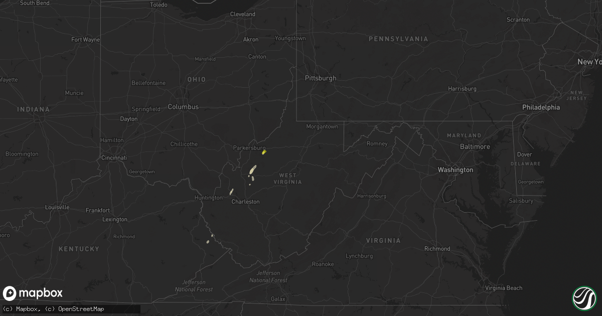
Hail Map in West Virginia on August 3, 2021
Get this storm
August 3 map
$229
one time, instant access
Download today. No call, no setup
Keep the $229
Bought the map and want the full workflow? Apply the entire $229 to a subscription within 7 days. None of it is wasted.
Every map, not just this one
This buys you this map. Subscription and you get every map we run, in the markets you choose from a few cities to whole states to nationwide. Plus real-time alerts the moment a storm fires.
Contact data
Name, contact info, occupancy, even credit band for addresses in the footprint. You go from where it hit to who to call.
Become the source they trust
Unlimited branding weather history reports on demand. You already have the documented answer ready for the property owner, and you are the one who showed up with it.
Property data and RoofTrace estimates
Pull up any address you have got, its value and the exact code rules for that jurisdiction, straight from One Click Code. Then RoofTrace estimates the squares, pitch, and roof value, priced the way you price.
Storm reports in West Virginia
West Virginia
| Date | Description |
|---|---|
| 08/03/20216:34 PM CDT | Tree uprooted. |
| 08/03/20216:30 PM CDT | Several downed trees and powerlines down with a tree down on a home on eleanor circle. |
| 08/03/20215:42 PM CDT | Multiple trees down around jones ridge ini jackson county... Wv. |
| 08/03/20214:30 PM CDT | Four trees down on harmony road near jones ridge. |
| 08/03/20214:00 PM CDT | Tree knocked down on rt33 blocking road with power lines. |
| 08/03/20214:00 PM CDT | Tree down on windyville road due to high wind. |
| 08/03/20213:50 PM CDT | Tree reported across windyville rd. |
| 08/03/20213:50 PM CDT | Tree reported down across the entirety of stover fork rd. Lines down also. |
| 08/03/20213:35 PM CDT | Tree and power lines reported down. |
| 08/03/20213:26 PM CDT | Tree reported across vicars ridge rd. |
| 08/03/20211:09 AM CDT | At 609 PM EDT, a severe thunderstorm was located 8 miles southwest of North Bend State Park, or 10 miles west of Harrisville, moving northeast at 25 mph. HAZARD...60 mph wind gusts and quarter size hail. SOURCE...Radar indicated. IMPACT...Hail damage to vehicles is expected. Expect wind damage to roofs, siding, and trees. Locations impacted include... North Bend State Park, Ellenboro, Cairo, Hebron, Pike, Nutter Farm, Maxwell, Petroleum and Highland.This includes Route 50 in West Virginia between mile markers 26 and38. |
| 08/03/202112:15 AM CDT | At 514 PM EDT, a severe thunderstorm was located over Conder, or 7 miles west of Williamson, moving northeast at 25 mph. HAZARD...60 mph wind gusts and penny size hail. SOURCE...Radar indicated. IMPACT...Expect damage to roofs, siding, and trees. This severe thunderstorm will be near... Hatfield Station around 520 PM EDT. Whitepost around 525 PM EDT. |
| 08/03/202112:04 AM CDT | At 503 PM EDT, a severe thunderstorm was located near Spencer, moving north at 20 mph. HAZARD...60 mph wind gusts and quarter size hail. SOURCE...Radar indicated. IMPACT...Hail damage to vehicles is expected. Expect wind damage to roofs, siding, and trees. Locations impacted include... Elizabeth, Reedy, Lucille, Cherry, Peewee, Morristown and Palestine. |
All States Impacted by Hail Map on August 3, 2021
Cities Impacted by Hail Map on August 3, 2021
- Stehekin, WA
- Naches, WA
- Cove, OR
- Encino, TX
- Ripley, WV
- Gay, WV
- Thorp, WA
- Easton, WA
- Cle Elum, WA
- La Grande, OR
- Houghton Lake, MI
- Newberry, MI
- Union, OR
- Pullman, WA
- Colton, WA
- North Bend, WA
- Skykomish, WA
- Colville, WA
- Sultan, WA
- North Powder, OR
- Addy, WA
- Pikeville, KY
- Varney, KY
- Petroleum, WV
- Selah, WA
- Advent, WV
- Gandeeville, WV
- Darrington, WA
- Palouse, WA
- Cairo, WV
- Reedy, WV
- Le Roy, WV
- Eleanor, WV
- Red House, WV
- Lovely, KY
- Spencer, WV
- Burns, OR
- Ronald, WA
- Eckerman, MI
- Winfield, WV
- Dayton, WA
- Peshastin, WA
- Leavenworth, WA
- Diamond, OR
- Drewsey, OR
- Wagon Mound, NM
- Palestine, WV
- Hurricane, WV
- Viola, ID


