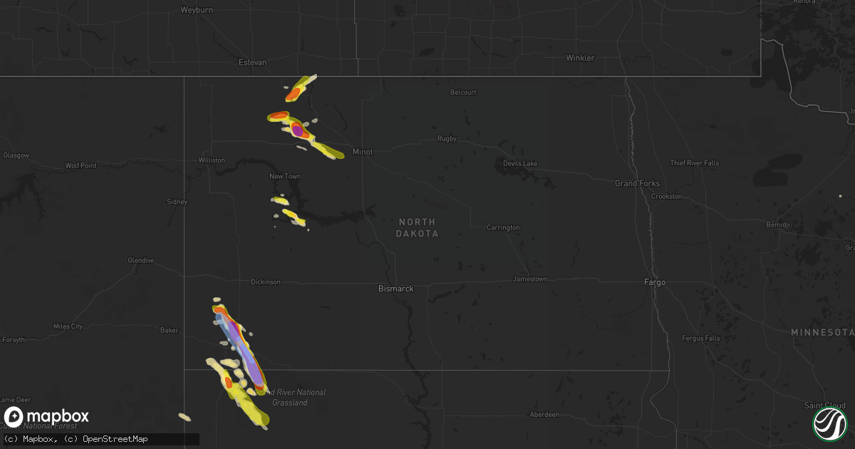
Hail Map in North Dakota on August 3, 2019
Get this storm
August 3 map
$229
one time, instant access
Download today. No call, no setup
Keep the $229
Bought the map and want the full workflow? Apply the entire $229 to a subscription within 7 days. None of it is wasted.
Every map, not just this one
This buys you this map. Subscription and you get every map we run, in the markets you choose from a few cities to whole states to nationwide. Plus real-time alerts the moment a storm fires.
Contact data
Name, contact info, occupancy, even credit band for addresses in the footprint. You go from where it hit to who to call.
Become the source they trust
Unlimited branding weather history reports on demand. You already have the documented answer ready for the property owner, and you are the one who showed up with it.
Property data and RoofTrace estimates
Pull up any address you have got, its value and the exact code rules for that jurisdiction, straight from One Click Code. Then RoofTrace estimates the squares, pitch, and roof value, priced the way you price.
Storm reports in North Dakota
North Dakota
| Date | Description |
|---|---|
| 08/03/20196:48 PM CDT | Window broken due to wind driven hail. |
| 08/03/20196:36 PM CDT | A local report indicates 1.25 inch wind near 3 E GASCOYNE |
| 08/03/20196:30 PM CDT | 75 mph wind gusts and quarter size hail reported just east of scranton. |
| 08/03/20196:30 PM CDT | A local report indicates 1.00 inch wind near SCRANTON |
| 08/03/20196:25 PM CDT | Relayed via broadcast media. |
| 08/03/20195:57 PM CDT | Relayed via broadcast media. |
| 08/03/20195:55 PM CDT | Significant crop damage reported. |
| 08/03/20195:42 PM CDT | Patio furniture and outdoor equipment tossed. |
| 08/03/20195:20 PM CDT | A local report indicates 1.75 inch wind near 3 NNE BOWBELLS |
| 08/03/20194:54 PM CDT | A local report indicates 1.00 inch wind near 12 NW AMIDON |
| 08/03/20192:45 AM CDT | At 745 PM MDT, a severe thunderstorm was located near Ludlow, or 21 miles northeast of Buffalo, moving southeast at 30 mph. HAZARD...60 mph wind gusts and quarter size hail. SOURCE...Radar indicated. IMPACT...Hail damage to vehicles is expected. Expect wind damage to roofs, siding, and trees. Hail may accumulate on roadways causing hazardous travel. Locations impacted include... Ludlow, Ralph, North Cave Hills and northwestern Slim Buttes. |
| 08/03/20192:30 AM CDT | At 729 PM CDT, a severe thunderstorm was located 6 miles southwest of Berthold, or 24 miles east of Stanley, moving east at 25 mph. HAZARD...60 mph wind gusts and quarter size hail. SOURCE...Radar indicated. IMPACT...Hail damage to vehicles is expected. Expect wind damage to roofs, siding, and trees. This severe thunderstorm will be near... Berthold around 740 PM CDT. Des Lacs around 800 PM CDT.Other locations impacted by this severe thunderstorm include Tagus. |
| 08/03/20191:40 AM CDT | At 639 PM MDT, a severe thunderstorm was located 9 miles northeast of Ludlow, or 22 miles southeast of Bowman, moving southeast at 25 mph. HAZARD...60 mph wind gusts and half dollar size hail. SOURCE...Radar indicated. IMPACT...Hail damage to vehicles is expected. Expect wind damage to roofs, siding, and trees. Locations impacted include... Ralph and northwestern Slim Buttes. |
| 08/03/20191:30 AM CDT | At 629 PM CDT, a severe thunderstorm was located near Blaisdell, or 13 miles east of Stanley, moving east at 15 mph. HAZARD...Golf ball size hail and 70 mph wind gusts. SOURCE...Radar indicated. IMPACT...People and animals outdoors will be injured. Expect hail damage to roofs, siding, windows, and vehicles. Expect considerable tree damage. Wind damage is also likely to mobile homes, roofs, and outbuildings. This severe thunderstorm will be near... Blaisdell around 640 PM CDT.Other locations impacted by this severe thunderstorm include Hartlandand Tagus. |
| 08/03/20191:20 AM CDT | At 619 PM CDT/519 PM MDT/, a severe thunderstorm was located over Mckenzie Bay Recreation Area, or 23 miles northeast of Killdeer, moving southeast at 15 mph. HAZARD...60 mph wind gusts and half dollar size hail. SOURCE...Radar indicated. IMPACT...Hail damage to vehicles is expected. Expect wind damage to roofs, siding, and trees. This severe thunderstorm will remain over mainly rural areas of northeastern Dunn and northwestern Mercer Counties, including the following locations... Twin Buttes. |
| 08/03/201912:38 AM CDT | At 538 PM CDT, a severe thunderstorm was located 5 miles northeast of Lostwood, or 15 miles north of Stanley, moving east at 15 mph. HAZARD...60 mph wind gusts and half dollar size hail. SOURCE...Radar indicated. IMPACT...Hail damage to vehicles is expected. Expect wind damage to roofs, siding, and trees. This severe thunderstorm will remain over mainly rural areas of northwestern Ward, south central Burke and northeastern Mountrail Counties, including the following locations... Coulee. |
| 08/03/201912:04 AM CDT | At 504 PM CDT, a severe thunderstorm was located 7 miles southwest of Bowbells, moving northeast at 25 mph. HAZARD...60 mph wind gusts and quarter size hail. SOURCE...Radar indicated. IMPACT...Hail damage to vehicles is expected. Expect wind damage to roofs, siding, and trees. This severe thunderstorm will be near... Bowbells around 520 PM CDT. |
| 08/02/201911:50 PM CDT | At 450 PM MDT, a severe thunderstorm was located 11 miles northeast of Bowman, moving southeast at 25 mph. HAZARD...Tennis ball size hail and 70 mph wind gusts. SOURCE...Radar indicated. IMPACT...People and animals outdoors will be injured. Expect hail damage to roofs, siding, windows, and vehicles. Expect considerable tree damage. Wind damage is also likely to mobile homes, roofs, and outbuildings. This severe thunderstorm will be near... Scranton around 520 PM MDT. Reeder around 535 PM MDT.Other locations impacted by this severe thunderstorm include BowmanHaley Dam, Bucyrus, Buffalo Springs and Gascoyne. |
| 08/02/201911:42 PM CDT | At 442 PM CDT, a severe thunderstorm was located near Powers Lake, or 20 miles southwest of Bowbells, moving east at 25 mph. HAZARD...60 mph wind gusts and half dollar size hail. SOURCE...Radar indicated. IMPACT...Hail damage to vehicles is expected. Expect wind damage to roofs, siding, and trees. This severe thunderstorm will remain over mainly rural areas of southwestern Burke County, including the following locations... Coteau. |
| 08/02/201911:37 PM CDT | At 437 PM MDT, a severe thunderstorm was located 5 miles southwest of Amidon, moving southeast at 15 mph. HAZARD...Two inch hail and 70 mph wind gusts. SOURCE...Radar indicated. IMPACT...People and animals outdoors will be injured. Expect hail damage to roofs, siding, windows, and vehicles. Expect considerable tree damage. Wind damage is also likely to mobile homes, roofs, and outbuildings. This severe thunderstorm will remain over mainly rural areas of south central Slope County. |
| 08/02/201911:15 PM CDT | At 414 PM MDT, a severe thunderstorm was located over Amidon, moving southeast at 25 mph. HAZARD...Two inch hail and 70 mph wind gusts. SOURCE...Radar indicated. IMPACT...People and animals outdoors will be injured. Expect hail damage to roofs, siding, windows, and vehicles. Expect considerable tree damage. Wind damage is also likely to mobile homes, roofs, and outbuildings. This severe thunderstorm will remain over mainly rural areas of eastern Slope County. |
| 08/02/201910:51 PM CDT | At 350 PM MDT, a severe thunderstorm was located 11 miles northwest of Amidon, moving east at 25 mph. HAZARD...60 mph wind gusts and half dollar size hail. SOURCE...Radar indicated. IMPACT...Hail damage to vehicles is expected. Expect wind damage to roofs, siding, and trees. This severe thunderstorm will be near... Amidon around 410 PM MDT. |
| 08/02/20197:00 PM CDT | Dime to half dollar sized hail. Time estimated from radar. Lots of crop and hay damage. |
All States Impacted by Hail Map on August 3, 2019
Cities Impacted by Hail Map on August 3, 2019
- Bowman, ND
- Makinen, MN
- Lance Creek, WY
- Ozark, AL
- Newton, AL
- Duluth, MN
- Canyon, MN
- Upton, WY
- Newcastle, WY
- Menasha, WI
- Brownfield, TX
- Saginaw, MN
- Palermo, ND
- Stanley, ND
- Killdeer, ND
- Halliday, ND
- Plaza, ND
- Berthold, ND
- Des Lacs, ND
- Powers Lake, ND
- Hammond, MT
- Bigfork, MN
- Reva, SD
- Kerrick, MN
- Moose Lake, MN
- Barnum, MN
- Lagrange, WY
- Lebanon, ME
- Reeder, ND
- Scranton, ND
- Ralph, SD
- Lodgepole, SD
- Tombstone, AZ
- Beulah, ND
- Brimson, MN
- Wheatland, WY
- Ludlow, SD
- Camp Douglas, WI
- Athol, MA
- Pulaski, WI
- Belle Fourche, SD
- Muleshoe, TX
- Ravena, NY
- Hannacroix, NY
- Coeymans Hollow, NY
- Weston, WY
- Athens, AL
- Vernon, AL
- Rhame, ND
- Prairie City, SD
- Lancaster, PA
- Abernathy, TX
- Amherst, TX
- Willcox, AZ
- Fort Rucker, AL
- Athelstane, WI
- Buffalo, SD
- Wilson, TX
- Post, TX
- Chugwater, WY
- Flaxton, ND
- Bowbells, ND
- Verbena, AL
- Marbury, AL
- Tucson, AZ
- Evart, MI
- Gordon, WI
- Friona, TX
- Hardin, MT
- Oconto Falls, WI
- Abrams, WI
- Amidon, ND
- New England, ND
- Volborg, MT
- Stratford, OK
- Somers, NY
- Purdys, NY
- Carmel, NY
- Mahopac, NY
- Shallowater, TX
- Boyes, MT
- Biddle, MT
- Capitol, MT
- Medora, ND
- Lena, WI
- Minneapolis, MN
- Salt Lake City, UT
- Crivitz, WI
- Colfax, WI
- Elk Mound, WI
- Manville, WY
- Moorcroft, WY
- Rhinebeck, NY
- Selkirk, NY
- Gillett, WI
- Donnybrook, ND
- Kenmare, ND
- Berry, AL
- Askov, MN
- Mandaree, ND
- Cotton, MN
- Wetumpka, AL
- Winter, WI
- Nashville, TN
- Franklin, TN
- Brentwood, TN
- Red Hook, NY
- Goldens Bridge, NY
- North Salem, NY
- Brewster, NY
- Holmes, NY
- Croton Falls, NY
- Patterson, NY
- Granby, MA
- Belchertown, MA
- Amherst, MA
- Aladdin, WY
- Chippewa Lake, MI
- Big Rapids, MI
- Hersey, MI
- Rodney, MI
- Hohenwald, TN
- Ropesville, TX
- Meadow, TX
- Levelland, TX
- Solon Springs, WI
- Rogers, NM
- Cloquet, MN
- Carlton, MN
- Clinton Corners, NY
- Berlin, WI
- Green Lake, WI
- Charleston, MO
- Fredonia, WI
- Saukville, WI
- Crane Hill, AL
- Cullman, AL
- Logan, AL
- Surprise, NY
- Greenville, NY
- Earlton, NY
- Midland City, AL
- Bisbee, AZ
- Bruno, MN
- Portales, NM
- Acra, NY
- Lignite, ND
- Broadus, MT
- Cornell, WI
- Boyd, WI
- Clarksville, TN
- Payson, AZ
- Seymour, WI
- Brillion, WI
- Ada, OK
- Asher, OK
- Konawa, OK
- Bardwell, KY
- Sandisfield, MA
- Monterey, MA
- Farwell, TX
- Palenville, NY
- Hadley, MA
- Heflin, AL
- Carbon Hill, AL
- West Coxsackie, NY
- Holcombe, WI
- Sundown, TX
- Douglas, WY
- Garrett, WY
- Lurgan, PA
- Newburg, PA
- Shippensburg, PA
- Orrstown, PA
- Southside, TN
- Greenleaf, WI
- Boulder Junction, WI
- Middleburgh, NY
- Rensselaerville, NY
- Preston Hollow, NY
- Orange, MA
- New Salem, MA
- San Simon, AZ
- Lubbock, TX
- Clanton, AL
- Billingsley, AL
- Ira, TX
- Snyder, TX
- Benson, AZ
- Butternut, WI
- Deerfield, WI
- Cambridge, WI
- Stephenson, MI
- Daggett, MI
- Sonoita, AZ
- Manitowish Waters, WI
- Autaugaville, AL
- Milton, NH
- Rochester, NH
- Sandy, UT
- Alpine, UT
- Marshall, WI
- Defuniak Springs, FL
- Menomonie, WI
- Crown King, AZ
- Round Top, NY
- Collinwood, TN
- Tuskegee Institute, AL
- Tuskegee, AL
- Osage, WY
- Hayward, WI
- Cerulean, KY
- West Bend, WI
- Chetek, WI
- Baker, FL
- Crestview, FL
- Gresham, WI
- Dallas, WI
- Barron, WI
- Sylacauga, AL
- Jemez Springs, NM
- Eagle River, WI
- Rhinelander, WI
- Three Lakes, WI
- Iron River, MI
- Texico, NM
- Savannah, TN
- Hulett, WY
- Hatfield, MA
- South Hadley, MA
- Sherwood, ND
- Alcove, NY
- South Bethlehem, NY
- Coxsackie, NY
- Climax, NY
- Northampton, MA
- Clifton, TN
- Patagonia, AZ
- Notasulga, AL
- Princeton, WI
- Rockford, AL
- Wallace, MI
- New Town, ND
- Bath Springs, TN
- Oakman, AL
- Kaukauna, WI
- Carpenter, WY
- Culleoka, TN
- Oconto, WI
- Bitely, MI
- Saint Louis, MI
- Durham, NY
- Kevil, KY
- La Center, KY
- Forest Junction, WI
- Rio Rico, AZ
- Blandford, MA
- Granville, MA
- Hettinger, ND
- Schodack Landing, NY
- Delmar, NY
- Albany, NY
- Slingerlands, NY
- West Camp, NY
- Saugerties, NY
- Germantown, NY
- Malden On Hudson, NY
- Peshtigo, WI
- Marinette, WI
- Kingston, NY
- Barrytown, NY
- New Milford, CT


