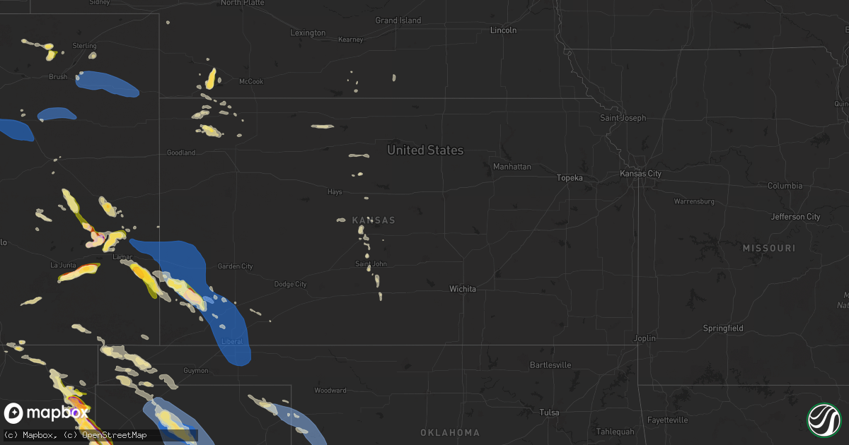
Hail Map in Kansas on August 2, 2025
Get this storm
August 2 map
$229
one time, instant access
Download today. No call, no setup
Keep the $229
Bought the map and want the full workflow? Apply the entire $229 to a subscription within 7 days. None of it is wasted.
Every map, not just this one
This buys you this map. Subscription and you get every map we run, in the markets you choose from a few cities to whole states to nationwide. Plus real-time alerts the moment a storm fires.
Contact data
Name, contact info, occupancy, even credit band for addresses in the footprint. You go from where it hit to who to call.
Become the source they trust
Unlimited branding weather history reports on demand. You already have the documented answer ready for the property owner, and you are the one who showed up with it.
Property data and RoofTrace estimates
Pull up any address you have got, its value and the exact code rules for that jurisdiction, straight from One Click Code. Then RoofTrace estimates the squares, pitch, and roof value, priced the way you price.
Storm reports in Kansas
Kansas
| Date | Description |
|---|---|
| 08/02/202512:47 AM CDT | Mesonet ur350. |
| 08/02/202512:42 AM CDT | Seward county em sent a picture of power poles down roughly 3 miles east of the us-160 and us-83 intersection. Time estimated from radar. |
| 08/02/202512:42 AM CDT | Corrects previous tstm wnd dmg report from 8 nw kismet. Seward county em reported17 power poles down roughly 3 miles east of the us-160 and us-83 intersection. Time est |
| 08/02/202512:38 AM CDT | Mesonet up407. |
| 08/02/202512:32 AM CDT | Em reported tin roof peeled back on an outbuilding and light post leaning. |
| 08/02/202512:29 AM CDT | Seward county em reported estimated 60 mph wind gusts at us-160 and us-83. |
| 08/02/202512:29 AM CDT | Semi blown over from thunderstorm wind. Time estimated via radar. |
| 08/02/202512:28 AM CDT | Mesonet station up407 0.6 sw hayne |
| 08/02/202512:04 AM CDT | Kansas state mesonet in satanta. |
| 08/01/202511:00 PM CDT | Electrical poles broken and down. Report via social media. |
| 08/01/202510:58 PM CDT | Ambient weather network site: videra weather. |
| 08/01/202510:32 PM CDT | Kjhn reported wind gust 94 mph. |
| 08/01/202510:30 PM CDT | Estimated 50-60 mph winds were also reported at the same location at this time. The time was estimated by radar. |
| 08/01/202510:30 PM CDT | Estimated 50-60 mph wi |
| 08/01/202510:20 PM CDT | Public reported quarter size hail. |
| 08/01/202510:20 PM CDT | Public reported up to 6 inch tree limbs broken. Time estimated via radar. |
| 08/01/202510:10 PM CDT | Estimated 50 to 60 mph wind gusts. Quarter sized hail was also reported at the same time and location. Time was estimated by radar. |
All States Impacted by Hail Map on August 2, 2025
Cities Impacted by Hail Map on August 2, 2025
- Mud Butte, SD
- Union Center, SD
- Buffalo, MT
- Alma, GA
- Blackshear, GA
- McRae Helena, GA
- Baxley, GA
- Roosevelt, TX
- Trinchera, CO
- Rocksprings, TX
- Opelika, AL
- Phenix City, AL
- Junction, TX
- Sonora, TX
- Salem, AL
- Surrency, GA
- Moody, TX
- Gatesville, TX
- Lorida, FL
- Round Mountain, TX
- Spicewood, TX
- Jewett, TX
- Caldwell, TX
- Temple, TX
- Belton, TX
- Chester, MT
- Hunt, TX
- Marquez, TX
- Little River Academy, TX
- Holland, TX
- Rogers, TX
- Ocate, NM
- Thorndale, TX
- Lexington, TX
- Fredericksburg, TX
- Watrous, NM
- Paige, TX
- Giddings, TX
- Burton, TX
- Brenham, TX
- Vanderpool, TX
- Burns, WY
- Cheyenne, WY
- Albin, WY
- Buckholts, TX
- Rockdale, TX
- San Saba, TX
- Eldorado, TX
- Ozona, TX
- Lolita, TX
- Kim, CO
- Pine Bluffs, WY
- Arenas Valley, NM
- Uvalde, TX
- La Grange, TX
- Limon, CO
- Grenville, NM
- Clayton, NM
- Byers, CO
- Harrison, NE
- Strasburg, CO
- Aurora, CO
- Watkins, CO
- Bennett, CO
- Deer Trail, CO
- Agate, CO
- Briggsdale, CO
- Rush, CO
- Model, CO
- Trinidad, CO
- Raton, NM
- Hugo, CO
- Karval, CO
- Fort Morgan, CO
- Ordway, CO
- New Raymer, CO
- Woodrow, CO
- Lindon, CO
- Stoneham, CO
- Alliance, NE
- Socorro, NM
- Goliad, TX
- Bridger, MT
- Carrizo Springs, TX
- La Junta, CO
- Akron, CO
- Merino, CO
- Penrose, CO
- Canon City, CO
- Capulin, NM
- Kit Carson, CO
- Las Animas, CO
- Lodge Grass, MT
- Florissant, CO
- Des Moines, NM
- Sterling, CO
- Three Rivers, TX
- George West, TX
- Haswell, CO
- Folsom, NM
- Rushville, NE
- Hasty, CO
- Calliham, TX
- Tilden, TX
- Eads, CO
- Utopia, TX
- Big Wells, TX
- Otis, CO
- Yuma, CO
- Wray, CO
- Eckley, CO
- McClave, CO
- Winnett, MT
- Freer, TX
- Sedan, NM
- Wiley, CO
- San Diego, TX
- Lambert, MT
- Sheridan Lake, CO
- Weskan, KS
- Olney Springs, CO
- Roundup, MT
- Realitos, TX
- Stratton, NE
- Whitetail, MT
- Venango, NE
- Palisade, NE
- Pine Ridge, SD
- Scobey, MT
- Holly, CO
- Syracuse, KS
- Tribune, KS
- Wounded Knee, SD
- Benkelman, NE
- Max, NE
- Flaxville, MT
- McDonald, KS
- Coolidge, KS
- Kendall, KS
- Pritchett, CO
- Bird City, KS
- Atwood, KS
- Johnson, KS
- Lakin, KS
- Amistad, NM
- Lamar, CO
- Ulysses, KS
- Manter, KS
- Dalhart, TX
- Granada, CO
- Torrington, WY
- Nara Visa, NM
- Fayetteville, TX
- Colby, KS
- Outlook, MT
- Levant, KS
- Raymond, MT
- Hartley, TX
- Milan, GA
- Channing, TX
- Kenton, OK
- Satanta, KS
- Sublette, KS
- Moscow, KS
- Hugoton, KS
- Kismet, KS
- Reserve, MT
- Adrian, TX
- Boise City, OK
- Liberal, KS
- Walsh, CO
- Lenora, KS
- Plentywood, MT
- Vega, TX
- Logan, NM
- Ludell, KS
- Keyes, OK
- Logan, KS
- Prairie View, KS
- Plains, KS
- Broadus, MT
- Hooker, OK
- Tyrone, OK
- Turpin, OK
- Forgan, OK
- La Crosse, KS
- Phillipsburg, KS
- Natoma, KS
- Glade, KS
- Bison, KS
- Woodston, KS
- Texhoma, OK
- Naponee, NE
- Hildreth, NE
- Bloomfield, NE
- Paradise, KS
- Felt, OK
- Bloomington, NE
- Franklin, NE
- Great Bend, KS
- Meade, KS
- Hereford, TX
- Alton, KS
- Albert, KS
- Beaver, OK
- Balko, OK
- St John, KS
- Hoisington, KS
- Pawnee Rock, KS
- Russell, KS
- Stratford, TX
- Waldo, KS
- Macksville, KS
- Dumas, TX
- Cactus, TX
- Sunray, TX
- Blue Hill, NE
- Stafford, KS
- Turon, KS
- Iuka, KS
- Perryton, TX
- Ellinwood, KS
- Pratt, KS
- Booker, TX
- Gruver, TX
- Morse, TX
- Stinnett, TX
- Follett, TX
- Sawyer, KS
- Higgins, TX
- Canadian, TX
- Lipscomb, TX
- Medicine Lodge, KS
- Masterson, TX
- Arnett, OK
- Fritch, TX
- Borger, TX
- Panhandle, TX
- Skellytown, TX
- Durham, OK
- Crawford, OK
- Cheyenne, OK
- Hammon, OK
- Leedey, OK
- Campo, CO
- Hollis, OK
- Vinson, OK
- Goodwell, OK
- Claude, TX
- Altus, OK
- Olustee, OK
- Gould, OK
- Duke, OK
- Blair, OK
- Mangum, OK
- Elmer, OK
- Altus Afb, OK
- Eldorado, OK
- Quanah, TX
- Headrick, OK
- Chillicothe, TX
- Tipton, OK
- Quitaque, TX
- Vernon, TX
- Odell, TX
- Frederick, OK
- Davidson, OK
- Denver, CO
- Otis, KS
- Guide Rock, NE
- Osborne, KS
- Oklaunion, TX
- Harrold, TX
- Hollister, OK
- Loveland, OK
- Crowell, TX


