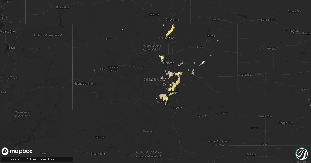
Hail Map in Colorado on July 31, 2023
Get this storm
July 31 map
$229
one time, instant access
Download today. No call, no setup
Keep the $229
Bought the map and want the full workflow? Apply the entire $229 to a subscription within 7 days. None of it is wasted.
Every map, not just this one
This buys you this map. Subscription and you get every map we run, in the markets you choose from a few cities to whole states to nationwide. Plus real-time alerts the moment a storm fires.
Contact data
Name, contact info, occupancy, even credit band for addresses in the footprint. You go from where it hit to who to call.
Become the source they trust
Unlimited branding weather history reports on demand. You already have the documented answer ready for the property owner, and you are the one who showed up with it.
Property data and RoofTrace estimates
Pull up any address you have got, its value and the exact code rules for that jurisdiction, straight from One Click Code. Then RoofTrace estimates the squares, pitch, and roof value, priced the way you price.
Storm reports in Colorado
Colorado
| Date | Description |
|---|---|
| 07/31/20236:47 PM CDT | Off-duty nws employee reported a brief tornado near carr. Numerous photos from social media also confirm. The location of this report was estimated based on photo and r |
| 07/30/202310:30 PM CDT | A local report indicates 1.00 inch wind near 8 NE Black Forest |
| 07/30/20239:58 PM CDT | A local report indicates 1.00 inch wind near 4 SW Black Forest |
| 07/30/20239:56 PM CDT | A local report indicates 1.00 inch wind near 4 W Falcon |
| 07/30/20239:49 PM CDT | Report from mping: quarter |
| 07/30/20239:45 PM CDT | A local report indicates 1.00 inch wind near 1 SE Manitou Springs |
| 07/30/20239:42 PM CDT | Report from mping: quarter |
| 07/30/20239:25 PM CDT | A local report indicates 1.50 inch wind near 6 NNE Colorado Springs |
| 07/30/20239:24 PM CDT | Report from mping: quarter |
| 07/30/20239:24 PM CDT | A local report indicates 1.00 inch wind near 7 SSW Black Forest |
| 07/30/20239:23 PM CDT | A local report indicates 1.00 inch wind near 4 NNE Colorado Springs |
| 07/30/20239:20 PM CDT | A local report indicates 1.00 inch wind near 7 NNW Peterson AFB |
| 07/30/20239:20 PM CDT | Report from mping: half dollar |
| 07/30/20239:17 PM CDT | A local report indicates 1.00 inch wind near 7 NNE Colorado Springs |
| 07/30/20239:16 PM CDT | A local report indicates 1.00 inch wind near 5 NNE Colorado Springs |
| 07/30/20239:15 PM CDT | A local report indicates 1.00 inch wind near 6 NNE Colorado Springs |
| 07/30/20239:14 PM CDT | A local report indicates 1.00 inch wind near 6 ENE Black Forest |
| 07/30/20239:13 PM CDT | A local report indicates 1.25 inch wind near 3 NNW Colorado Springs |
| 07/30/20239:10 PM CDT | Report from mping: half dollar |
| 07/30/20239:09 PM CDT | A local report indicates 1.00 inch wind near 3 NE Colorado Springs |
| 07/30/20239:06 PM CDT | A local report indicates 1.00 inch wind near 4 NNE Colorado Springs |
| 07/30/20239:00 PM CDT | Report from mping. |
| 07/30/20238:55 PM CDT | A local report indicates 1.25 inch wind near 6 NNW Kiowa |
| 07/30/20237:57 PM CDT | Mesonet station gw2494 elizabeth. |
| 07/30/20237:57 PM CDT | Mesonet station co167 036e04190rws1rhs - 1.7 mi w of m. |
| 07/30/20237:46 PM CDT | Report from mping: quarter |
All States Impacted by Hail Map on July 31, 2023
Cities Impacted by Hail Map on July 31, 2023
- Summerfield, FL
- Ocala, FL
- Oxford, FL
- Webster, FL
- Carthage, NC
- West End, NC
- Pinehurst, NC
- Southern Pines, NC
- Vass, NC
- Prescott, AZ
- Souris, ND
- Ragley, LA
- Reeves, LA
- Flagstaff, AZ
- Haines City, FL
- Kissimmee, FL
- Saint Cloud, FL
- Leupp, AZ
- Groveland, FL
- Clermont, FL
- Wauchula, FL
- Winter Garden, FL
- Gillette, WY
- Rozet, WY
- Orlando, FL
- Geismar, LA
- Darrow, LA
- Deland, FL
- Frostproof, FL
- Gonzales, LA
- Avon Park, FL
- Kinder, LA
- Williams, AZ
- Baton Rouge, LA
- Carencro, LA
- Lafayette, LA
- Sedalia, CO
- Clewiston, FL
- Eagle Springs, NC
- Robbins, NC
- Gainesville, FL
- Howard, CO
- Cotopaxi, CO
- Happy Jack, AZ
- Fort Meade, FL
- Concho, AZ
- Lake Helen, FL
- Debary, FL
- Orange City, FL
- Deltona, FL
- Lake Mary, FL
- Sanford, FL
- Gloster, MS
- Centreville, MS
- Chambers, AZ
- Zachary, LA
- Baker, LA
- Seligman, AZ
- Slaughter, LA
- Hampton, FL
- Tuba City, AZ
- Auburndale, FL
- Alachua, FL
- Newberry, FL
- Sorrento, LA
- Convent, LA
- Donaldsonville, LA
- Saint James, LA
- Indian Lake Estates, FL
- Crownpoint, NM
- Jupiter, FL
- Palm Beach Gardens, FL
- Okeechobee, FL
- Glenrock, WY
- Interlachen, FL
- Stuart, FL
- Pioche, NV
- Pompano Beach, FL
- Welsh, LA
- Hawthorne, FL
- Christmas, FL
- Weston, WY
- Kramer, ND
- Bantry, ND
- Bottineau, ND
- Willow City, ND
- Moorcroft, WY
- Camp Verde, AZ
- Dewey, AZ
- Carr, CO
- Wellington, CO
- Nunn, CO
- Castle Rock, CO
- Golden, CO
- Boulder, CO
- Broomfield, CO
- Eldorado Springs, CO
- Arvada, CO
- Colorado Springs, CO
- Fort Collins, CO
- Louisville, CO
- Saint Francis, KS
- Cope, CO
- Manhattan, KS
- Westminster, CO
- Fort Morgan, CO
- Commerce City, CO
- Hill City, KS
- Bennett, CO
- Bird City, KS
- McDonald, KS
- Longford, KS
- Lindon, CO
- Kirk, CO
- Milford, KS
- Stockton, KS
- Anton, CO
- Wakarusa, KS
- Maple Hill, KS
- Denver, CO
- Hunter, KS
- Auburn, KS
- Berryton, KS
- Tipton, KS
- Junction City, KS
- Byers, CO
- Woodrow, CO
- Atwood, KS
- Wakefield, KS
- Beloit, KS
- Henderson, CO
- Colby, KS
- Woodston, KS
- Wray, CO
- Strasburg, CO
- Penokee, KS
- Selden, KS
- Glasco, KS
- Alma, KS
- Minneapolis, KS
- Morland, KS
- Brighton, CO
- Alton, KS
- Osborne, KS
- Idalia, CO
- Solomon, KS
- Levant, KS
- Luray, KS
- Bogue, KS
- Joes, CO
- Yuma, CO
- Bennington, KS
- Natoma, KS
- Barnard, KS
- Plainville, KS
- Damar, KS
- Rexford, KS
- Scranton, KS
- Lincoln, KS
- Chapman, KS
- Abilene, KS
- Elizabeth, CO
- Kiowa, CO
- Towner, ND
- Rugby, ND
- Tucson, AZ
- Marana, AZ
- Chaseley, ND
- Robinson, ND
- Bowman, ND
- Scranton, ND
- Elbert, CO
- Penrose, CO
- Littleton, CO
- Laramie, WY
- Littlefield, AZ
- Lone Tree, CO
- Branchville, SC
- Bamberg, SC
- Sedona, AZ
- Manitou Springs, CO
- Cascade, CO
- Kingman, AZ
- Dulce, NM
- Ekalaka, MT
- Kaplan, LA
- Florissant, CO
- Clark, CO
- Bellvue, CO
- Broadus, MT
- Alzada, MT
- Hammond, MT
- Hulett, WY
- Cope, SC
- Canon City, CO
- McClellanville, SC
- Awendaw, SC
- Anamoose, ND
- Camp Crook, SD
- Buffalo, SD
- Hackberry, AZ
- Iowa, LA
- Young, AZ
- Woodland Park, CO
- Bosler, WY
- Franktown, CO
- Fort Lauderdale, FL
- Deweyville, TX
- Peach Springs, AZ
- Moore Haven, FL
- Cripple Creek, CO
- Elloree, SC
- Santee, SC
- Ash Fork, AZ
- Livermore, CO
- Albany, LA
- Hammond, LA
- Buna, TX
- Parker, CO
- Florence, CO
- Orange, TX
- Lake George, CO
- Chinle, AZ
- Martin, ND
- Usaf Academy, CO
- Watkins, CO
- San Manuel, AZ
- Mammoth, AZ
- Harvey, ND
- Hurdsfield, ND
- Monument, CO
- Vidor, TX
- Abbeville, LA
- Gueydan, LA
- Broaddus, TX
- Franklin, LA
- Larkspur, CO
- Vinton, LA
- Silsbee, TX
- Kountze, TX
- Nederland, CO
- Upham, ND
- Divide, CO
- Coral Springs, FL
- Erath, LA
- Bowman, SC
- Wheatland, WY
- Lake Charles, LA
- Granite Canon, WY
- Bowdon, ND
- Akron, CO
- Agate, CO
- Concordia, MO
- Parachute, CO
- Lincoln, MO
- Cole Camp, MO
- Smoaks, SC
- Sedalia, MO
- Tuttle, ND
- Deer Trail, CO
- Saint George, SC
- Edwards, MO
- Stover, MO
- Peyton, CO
- Palm City, FL
- Victor, CO
- De Beque, CO
- Smithton, MO
- Mora, MO
- Hughesville, MO
- La Monte, MO
- Howey In The Hills, FL
- Ridgeville, SC
- Whitewater, MT
- Hinsdale, MT
- Climax Springs, MO
- Loring, MT
- Richland, MT
- Opheim, MT
- Larslan, MT
- Peerless, MT
- Houstonia, MO
- Marshall, MO
- Turner, MT
- Otis, CO
- Fleming, CO
- Carrollton, MO
- Alma, MO
- Blackburn, MO
- Waverly, MO
- Malta Bend, MO
- Sweet Springs, MO
- Norborne, MO
- Green Ridge, MO
- Knob Noster, MO
- Otterville, MO
- Florence, MO
- Versailles, MO
- Gravois Mills, MO
- Bogard, MO
- Miami, MO


