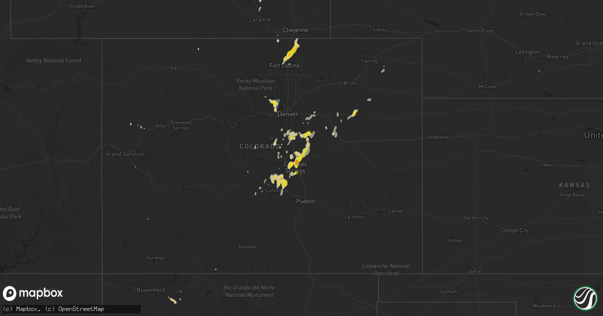
Hail Map on July 31, 2023
Get this storm
July 31 map
$229
one time, instant access
Download today. No call, no setup
Keep the $229
Bought the map and want the full workflow? Apply the entire $229 to a subscription within 7 days. None of it is wasted.
Every map, not just this one
This buys you this map. Subscription and you get every map we run, in the markets you choose from a few cities to whole states to nationwide. Plus real-time alerts the moment a storm fires.
Contact data
Name, contact info, occupancy, even credit band for addresses in the footprint. You go from where it hit to who to call.
Become the source they trust
Unlimited branding weather history reports on demand. You already have the documented answer ready for the property owner, and you are the one who showed up with it.
Property data and RoofTrace estimates
Pull up any address you have got, its value and the exact code rules for that jurisdiction, straight from One Click Code. Then RoofTrace estimates the squares, pitch, and roof value, priced the way you price.
States Impacted by Hail Map on July 31, 2023
Storm reports
Arizona
| Date | Description |
|---|---|
| 07/31/20235:00 PM CDT | Spotter showed an photo of a mixture of dime... Nickel and quarter sized hail. |
| 07/30/20239:35 PM CDT | Corrects previous tstm wnd gst report from 3 wsw marana. Awos station kavq marana regional airport. |
| 07/30/20239:15 PM CDT | Trees down blocking silverbell rd. North of cortaro farms rd. Reported on social media. Time estimated from radar. |
| 07/30/20238:40 PM CDT | Power poles down causing closure of mission rd. South of campus dr. Time estimated from radar. |
| 07/30/20237:56 PM CDT | Asos station ktus tucson international airport. |
| 07/30/20237:52 PM CDT | Corrects previous tstm wnd gst report from 6 sw tucson. Asos station ktus tucson international airport. |
| 07/30/20237:10 PM CDT | Tree down on owens pl. Time estimated from radar. |
Montana
| Date | Description |
|---|---|
| 07/31/20236:20 AM CDT | 0.44 rainfall and wind gust to 45 mph. |
| 07/31/20235:50 AM CDT | Corrects previous tstm wnd dmg report from 5 s opheim. Time estimated from radar. Trees were stripped. |
North Dakota
| Date | Description |
|---|---|
| 07/31/20236:40 PM CDT | Delayed report from yesterday. Time estimated from radar. Also had pea sized hail for about 5 minutes. Spotter reported that a nearby corn field was stripped down to st |
| 07/30/20239:21 PM CDT | Nickel and dime size hail still occurring 8 minutes after ping pong ball size hail was observed. |
Louisiana
| Date | Description |
|---|---|
| 07/31/20236:45 PM CDT | Reported large tree limbs down. |
| 07/31/20235:45 PM CDT | Image from facebook of a destroyed shed. |
| 07/31/20235:40 PM CDT | Tree knocked down in a yard. |
| 07/31/20235:36 PM CDT | Damage to tin roof at crusta memorial airport and damage to two hanger doors. |
| 07/31/20235:25 PM CDT | Trees down between maurice and milton. Time estimated based off radar. |
| 07/31/20235:15 PM CDT | Image of large tree branches from a hard wood tree broken from trunk. |
| 07/31/20234:57 PM CDT | Mobile home roof partially peeled off. Other reports of minor damage in the area. Time estimated based on radar. |
| 07/31/20234:45 PM CDT | Tree down near intersection of highland road and know hill drive. Relayed via social media. |
| 07/31/20234:40 PM CDT | Patio roof blown off in oak hills subdivision of baton rouge. Relayed via social media. |
| 07/31/20234:40 PM CDT | Few snapped trees... One uprooted tree... And minor metal damage at br proud news studio. |
| 07/31/20234:40 PM CDT | Tree on home in oak hills subdivision of baton rouge. |
| 07/31/20234:35 PM CDT | Tree down on the corner of forest drive and sholar drive. |
| 07/31/20234:35 PM CDT | Tree downed on powerline in jefferson terrace subdivision in baton rouge. |
| 07/31/20234:30 PM CDT | Corrects previous tstm wnd dmg report from 1 nw westminster. Report from mping: trees uprooted or snapped; roof blown off. |
| 07/31/20234:30 PM CDT | Tree on a house in broadmoor area. |
| 07/31/20234:30 PM CDT | Large tree fell on home with 3 people inside. No injuries reported. |
| 07/31/20234:30 PM CDT | Tree down in old goodwood subdivision of baton rouge. |
| 07/31/20234:30 PM CDT | *** 1 inj *** unknown structure collapse at 84 lumber relayed via social media... Seriously injuring one person. |
| 07/31/20234:25 PM CDT | Report from mping: trees uprooted or snapped; roof blown off. |
| 07/31/20233:59 PM CDT | Tree down across byfaul avenue in baker on social media via news outlet. |
North Carolina
| Date | Description |
|---|---|
| 07/31/20234:18 PM CDT | A tree was blown down onto north stokes road near lawsonville. |
| 07/31/20232:01 PM CDT | Tree down along midway road in rockingham... Nc. Time estimated by radar. |
| 07/31/20231:30 PM CDT | Several reports of down trees and/or powerlines from the 911 call center... Largely centered from carthage... Whispering pines through southern pines. Report will be up |
| 07/31/20231:28 PM CDT | Power outage of around 1...000 customers caused by fallen trees damaging equipment around southern pines. |
| 07/31/20231:25 PM CDT | Power outage of around 600 customers was called by fallen trees damaging equipment around whispering pines. |
| 07/31/20231:16 PM CDT | Tree down in the roadway near the intersection of hwy nc-22 and farm life school road. |
Texas
| Date | Description |
|---|---|
| 07/30/20237:00 PM CDT | Numerous trees down with minor structural damage to outbuildings. |
Florida
| Date | Description |
|---|---|
| 07/31/20232:25 PM CDT | Former nws employee/ hurricane specialist reports a tree down on highway 40... About a half mile west of the st. Johns river. Tree was estimated to be 8 inches in diame |
| 07/31/20232:20 PM CDT | The city of kissimmee has reported roof damage to a local store in association with a strong thunderstorm this afternoon. Time has been estimated via radar. |
| 07/31/20232:20 PM CDT | The city of kissimmee reported a tree had fallen on a residential structure during a strong thunderstorm this afternoon... Resulting in roof damage. Time estimated via |
| 07/31/20232:10 PM CDT | Tree down near sw county rd 18. Time of damage estimated by radar. |
| 07/31/202312:25 PM CDT | Two trees down across us 129 and nw 160 st. |
| 07/31/202312:06 PM CDT | Snapped tree near se 139th ln shared on social media. Time estimated by radar. |
Wyoming
| Date | Description |
|---|---|
| 07/31/20236:20 PM CDT | A local report indicates 1.50 inch wind near 6 SE Weston |
| 07/30/20238:22 PM CDT | Mesonet station wy1 8.4 s sibley peak |
| 07/30/20237:12 PM CDT | Power pole knocked down. Areas of gillette... Pine haven... And rozet without power for roughly 4 hours. |
South Carolina
| Date | Description |
|---|---|
| 07/31/20238:48 AM CDT | A dorchester county emergency manager reported a tree down along the 100 block of rebecca road. |
| 07/30/20239:43 PM CDT | Colleton county emergency management reported a tree down along the 13100 block and 12000 block of charleston highway due to thunderstorm outflow. |
| 07/30/20239:43 PM CDT | Colleton county emergency management reported a tree down along the 13100 block of charleston highway due to thunderstorm outflow. |
| 07/30/20239:36 PM CDT | Colleton county emergency management reported a tree down along the 8800 block of charleston highway due to thunderstorm outflow. |
| 07/30/20239:36 PM CDT | Colleton county emergency management reported a tree down along the 8800 block... 7000 block and 6700 block of charleston highway due to thunderstorm outflow. |
| 07/30/20239:25 PM CDT | Colleton county emergency management reported a tree down along the 2600 block of wesley grove road. |
| 07/30/20239:25 PM CDT | Colleton county emergency management reported a tree down near the intersection of wesley grove road and finlay lane. |
| 07/30/20239:19 PM CDT | Colleton county emergency management reported a tree down along 19500 block of augusta highway. |
| 07/30/20239:19 PM CDT | Colleton county emergency management reported a tree down along the 100 block of doctors creek road. |
| 07/30/20239:14 PM CDT | Colleton county emergency management reported power pole damage blocking both lanes along the 8900 block of bells highway. |
| 07/30/20239:04 PM CDT | Colleton county emergency management reported a tree down along the 500 block of hydrick road. |
| 07/30/20238:59 PM CDT | Colleton county emergency management reported a tree down along the 1700 block of george warren drive. |
| 07/30/20238:56 PM CDT | Tree blocking road at intersection of 1st texas road and gator loop in st. George. |
| 07/30/20238:56 PM CDT | A dorchester county emergency manager reported power lines down along the 1000 block of highway 15. |
| 07/30/20238:52 PM CDT | A dorchester county emergency manager reported a tree down on a house along the 100 block of st james road. |
| 07/30/20238:52 PM CDT | A dorchester county emergency manager reported a tree and power lines down along the 100 block of quaker street. |
| 07/30/20238:52 PM CDT | A dorchester county emergency manager reported a tree down along the 5200 block of east jim bilton boulevard. |
| 07/30/20238:51 PM CDT | A dorchester county emergency manager reported three pine trees down on a house along the 100 block of davis terrace. |
| 07/30/20238:51 PM CDT | A dorchester county emergency manager reported a tree down on a house along the 100 block of davis terrace. |
| 07/30/20238:48 PM CDT | A dorchester county emergency manager reported a tree down along the 200 block of cross creek road. |
| 07/30/20238:48 PM CDT | A dorchester county emergency manager reported a tree down along the 100 block of rebecca road. |
| 07/30/20238:45 PM CDT | Colleton county emergency management reported a tree down along the 2100 block of buckhead road. |
| 07/30/20238:45 PM CDT | A dorchester county emergency manager reported a tree down along the 300 block of friendship road. |
Colorado
| Date | Description |
|---|---|
| 07/31/20236:47 PM CDT | Off-duty nws employee reported a brief tornado near carr. Numerous photos from social media also confirm. The location of this report was estimated based on photo and r |
| 07/30/202310:30 PM CDT | A local report indicates 1.00 inch wind near 8 NE Black Forest |
| 07/30/20239:58 PM CDT | A local report indicates 1.00 inch wind near 4 SW Black Forest |
| 07/30/20239:56 PM CDT | A local report indicates 1.00 inch wind near 4 W Falcon |
| 07/30/20239:49 PM CDT | Report from mping: quarter |
| 07/30/20239:45 PM CDT | A local report indicates 1.00 inch wind near 1 SE Manitou Springs |
| 07/30/20239:42 PM CDT | Report from mping: quarter |
| 07/30/20239:25 PM CDT | A local report indicates 1.50 inch wind near 6 NNE Colorado Springs |
| 07/30/20239:24 PM CDT | Report from mping: quarter |
| 07/30/20239:24 PM CDT | A local report indicates 1.00 inch wind near 7 SSW Black Forest |
| 07/30/20239:23 PM CDT | A local report indicates 1.00 inch wind near 4 NNE Colorado Springs |
| 07/30/20239:20 PM CDT | Report from mping: half dollar |
| 07/30/20239:20 PM CDT | A local report indicates 1.00 inch wind near 7 NNW Peterson AFB |
| 07/30/20239:17 PM CDT | A local report indicates 1.00 inch wind near 7 NNE Colorado Springs |
| 07/30/20239:16 PM CDT | A local report indicates 1.00 inch wind near 5 NNE Colorado Springs |
| 07/30/20239:15 PM CDT | A local report indicates 1.00 inch wind near 6 NNE Colorado Springs |
| 07/30/20239:14 PM CDT | A local report indicates 1.00 inch wind near 6 ENE Black Forest |
| 07/30/20239:13 PM CDT | A local report indicates 1.25 inch wind near 3 NNW Colorado Springs |
| 07/30/20239:10 PM CDT | Report from mping: half dollar |
| 07/30/20239:09 PM CDT | A local report indicates 1.00 inch wind near 3 NE Colorado Springs |
| 07/30/20239:06 PM CDT | A local report indicates 1.00 inch wind near 4 NNE Colorado Springs |
| 07/30/20239:00 PM CDT | Report from mping. |
| 07/30/20238:55 PM CDT | A local report indicates 1.25 inch wind near 6 NNW Kiowa |
| 07/30/20237:57 PM CDT | Mesonet station co167 036e04190rws1rhs - 1.7 mi w of m. |
| 07/30/20237:57 PM CDT | Mesonet station gw2494 elizabeth. |
| 07/30/20237:46 PM CDT | Report from mping: quarter |
Missouri
| Date | Description |
|---|---|
| 07/31/20232:45 AM CDT | Tree and powerline damage southeast of cole camp close to the morgan county line. |
Cities Impacted by Hail Map on July 31, 2023
- Summerfield, FL
- Ocala, FL
- Oxford, FL
- Webster, FL
- Carthage, NC
- West End, NC
- Pinehurst, NC
- Southern Pines, NC
- Vass, NC
- Prescott, AZ
- Souris, ND
- Ragley, LA
- Reeves, LA
- Flagstaff, AZ
- Haines City, FL
- Kissimmee, FL
- Saint Cloud, FL
- Leupp, AZ
- Groveland, FL
- Clermont, FL
- Wauchula, FL
- Winter Garden, FL
- Gillette, WY
- Rozet, WY
- Orlando, FL
- Geismar, LA
- Darrow, LA
- Deland, FL
- Frostproof, FL
- Gonzales, LA
- Avon Park, FL
- Kinder, LA
- Williams, AZ
- Baton Rouge, LA
- Carencro, LA
- Lafayette, LA
- Sedalia, CO
- Clewiston, FL
- Eagle Springs, NC
- Robbins, NC
- Gainesville, FL
- Howard, CO
- Cotopaxi, CO
- Happy Jack, AZ
- Fort Meade, FL
- Concho, AZ
- Lake Helen, FL
- Debary, FL
- Orange City, FL
- Deltona, FL
- Lake Mary, FL
- Sanford, FL
- Gloster, MS
- Centreville, MS
- Chambers, AZ
- Zachary, LA
- Baker, LA
- Seligman, AZ
- Slaughter, LA
- Hampton, FL
- Tuba City, AZ
- Auburndale, FL
- Alachua, FL
- Newberry, FL
- Sorrento, LA
- Convent, LA
- Donaldsonville, LA
- Saint James, LA
- Indian Lake Estates, FL
- Crownpoint, NM
- Jupiter, FL
- Palm Beach Gardens, FL
- Okeechobee, FL
- Glenrock, WY
- Interlachen, FL
- Stuart, FL
- Pioche, NV
- Pompano Beach, FL
- Welsh, LA
- Hawthorne, FL
- Christmas, FL
- Weston, WY
- Kramer, ND
- Bantry, ND
- Bottineau, ND
- Willow City, ND
- Moorcroft, WY
- Camp Verde, AZ
- Dewey, AZ
- Carr, CO
- Wellington, CO
- Nunn, CO
- Castle Rock, CO
- Golden, CO
- Boulder, CO
- Broomfield, CO
- Eldorado Springs, CO
- Arvada, CO
- Colorado Springs, CO
- Fort Collins, CO
- Louisville, CO
- Saint Francis, KS
- Cope, CO
- Manhattan, KS
- Westminster, CO
- Fort Morgan, CO
- Commerce City, CO
- Hill City, KS
- Bennett, CO
- Bird City, KS
- McDonald, KS
- Longford, KS
- Lindon, CO
- Kirk, CO
- Milford, KS
- Stockton, KS
- Anton, CO
- Wakarusa, KS
- Maple Hill, KS
- Denver, CO
- Hunter, KS
- Auburn, KS
- Berryton, KS
- Tipton, KS
- Junction City, KS
- Byers, CO
- Woodrow, CO
- Atwood, KS
- Wakefield, KS
- Beloit, KS
- Henderson, CO
- Colby, KS
- Woodston, KS
- Wray, CO
- Strasburg, CO
- Penokee, KS
- Selden, KS
- Glasco, KS
- Alma, KS
- Minneapolis, KS
- Morland, KS
- Brighton, CO
- Alton, KS
- Osborne, KS
- Idalia, CO
- Solomon, KS
- Levant, KS
- Luray, KS
- Bogue, KS
- Joes, CO
- Yuma, CO
- Bennington, KS
- Natoma, KS
- Barnard, KS
- Plainville, KS
- Damar, KS
- Rexford, KS
- Scranton, KS
- Lincoln, KS
- Chapman, KS
- Abilene, KS
- Elizabeth, CO
- Kiowa, CO
- Towner, ND
- Rugby, ND
- Tucson, AZ
- Marana, AZ
- Chaseley, ND
- Robinson, ND
- Bowman, ND
- Scranton, ND
- Elbert, CO
- Penrose, CO
- Littleton, CO
- Laramie, WY
- Littlefield, AZ
- Lone Tree, CO
- Branchville, SC
- Bamberg, SC
- Sedona, AZ
- Manitou Springs, CO
- Cascade, CO
- Kingman, AZ
- Dulce, NM
- Ekalaka, MT
- Kaplan, LA
- Florissant, CO
- Clark, CO
- Bellvue, CO
- Broadus, MT
- Alzada, MT
- Hammond, MT
- Hulett, WY
- Cope, SC
- Canon City, CO
- McClellanville, SC
- Awendaw, SC
- Anamoose, ND
- Camp Crook, SD
- Buffalo, SD
- Hackberry, AZ
- Iowa, LA
- Young, AZ
- Woodland Park, CO
- Bosler, WY
- Franktown, CO
- Fort Lauderdale, FL
- Deweyville, TX
- Peach Springs, AZ
- Moore Haven, FL
- Cripple Creek, CO
- Elloree, SC
- Santee, SC
- Ash Fork, AZ
- Livermore, CO
- Albany, LA
- Hammond, LA
- Buna, TX
- Parker, CO
- Florence, CO
- Orange, TX
- Lake George, CO
- Chinle, AZ
- Martin, ND
- Usaf Academy, CO
- Watkins, CO
- San Manuel, AZ
- Mammoth, AZ
- Harvey, ND
- Hurdsfield, ND
- Monument, CO
- Vidor, TX
- Abbeville, LA
- Gueydan, LA
- Broaddus, TX
- Franklin, LA
- Larkspur, CO
- Vinton, LA
- Silsbee, TX
- Kountze, TX
- Nederland, CO
- Upham, ND
- Divide, CO
- Coral Springs, FL
- Erath, LA
- Bowman, SC
- Wheatland, WY
- Lake Charles, LA
- Granite Canon, WY
- Bowdon, ND
- Akron, CO
- Agate, CO
- Concordia, MO
- Parachute, CO
- Lincoln, MO
- Cole Camp, MO
- Smoaks, SC
- Sedalia, MO
- Tuttle, ND
- Deer Trail, CO
- Saint George, SC
- Edwards, MO
- Stover, MO
- Peyton, CO
- Palm City, FL
- Victor, CO
- De Beque, CO
- Smithton, MO
- Mora, MO
- Hughesville, MO
- La Monte, MO
- Howey In The Hills, FL
- Ridgeville, SC
- Whitewater, MT
- Hinsdale, MT
- Climax Springs, MO
- Loring, MT
- Richland, MT
- Opheim, MT
- Larslan, MT
- Peerless, MT
- Houstonia, MO
- Marshall, MO
- Turner, MT
- Otis, CO
- Fleming, CO
- Carrollton, MO
- Alma, MO
- Blackburn, MO
- Waverly, MO
- Malta Bend, MO
- Sweet Springs, MO
- Norborne, MO
- Green Ridge, MO
- Knob Noster, MO
- Otterville, MO
- Florence, MO
- Versailles, MO
- Gravois Mills, MO
- Bogard, MO
- Miami, MO