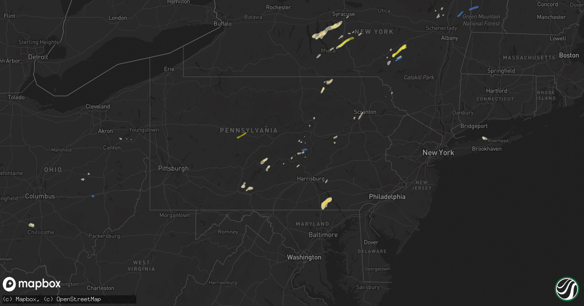
Hail Map in Pennsylvania on July 30, 2019
Get this storm
July 30 map
$229
one time, instant access
Download today. No call, no setup
Keep the $229
Bought the map and want the full workflow? Apply the entire $229 to a subscription within 7 days. None of it is wasted.
Every map, not just this one
This buys you this map. Subscription and you get every map we run, in the markets you choose from a few cities to whole states to nationwide. Plus real-time alerts the moment a storm fires.
Contact data
Name, contact info, occupancy, even credit band for addresses in the footprint. You go from where it hit to who to call.
Become the source they trust
Unlimited branding weather history reports on demand. You already have the documented answer ready for the property owner, and you are the one who showed up with it.
Property data and RoofTrace estimates
Pull up any address you have got, its value and the exact code rules for that jurisdiction, straight from One Click Code. Then RoofTrace estimates the squares, pitch, and roof value, priced the way you price.
Storm reports in Pennsylvania
Pennsylvania
| Date | Description |
|---|---|
| 07/30/20196:35 PM CDT | Branches and trees down across penn street. |
| 07/30/20196:10 PM CDT | Tree down across road in stewartstown |
| 07/30/20196:10 PM CDT | Multiple trees down between stewartstown and fawn grove. |
| 07/30/20194:55 PM CDT | Trees down across road. Constitution ave. And marcy ave. |
| 07/30/20194:50 PM CDT | Reports of trees and wires down mainly in the manchester township. |
| 07/30/20194:07 PM CDT | Multiple trees and wires down. |
| 07/30/20194:05 PM CDT | Multiple trees down codding and mac roads. |
| 07/30/20194:04 PM CDT | Downed trees and wires near sibley ave |
| 07/30/20194:00 PM CDT | Media photos of trees down near cemetery. Also reports of trees down in nearby duryea along phoenix street. |
| 07/30/20193:56 PM CDT | Trees and wires down across road |
| 07/30/20193:20 PM CDT | Tree down on a vehicle on mile post rd. |
| 07/30/20193:00 PM CDT | Large tree and lines down. Damaged shed. |
| 07/30/20192:35 PM CDT | Several trees down... Lines also reported down. Hail of unknown size. Facebook photos of trees. |
| 07/30/20192:08 PM CDT | Multiple trees down in west buffalo township. |
| 07/30/20191:00 PM CDT | Two trees down in the curwensville area. |
| 07/30/201912:00 PM CDT | 1 tree down on a utility pole/wires. |
| 07/30/20192:17 AM CDT | At 717 PM EDT, a severe thunderstorm was located over Shenks Ferry, moving northeast at 30 mph. HAZARD...60 mph wind gusts and half dollar size hail. SOURCE...Radar indicated. IMPACT...Hail damage to vehicles is expected. Expect wind damage to trees, roofs, and siding. Locations impacted include... Lancaster, Ephrata, Millersville, Willow Street, New Holland, Akron, Leola, Paradise, Reamstown, Strasburg, Quarryville, Gap, Adamstown, Terre Hill, Wakefield, Churchtown, Leacock, Smithville, Bareville and Safe Harbor.This includes The Pennsylvania Turnpike from mile markers 285 to 295. |
| 07/29/201911:59 PM CDT | At 459 PM EDT, a severe thunderstorm was located over Nescopeck, or over Berwick, moving northeast at 20 mph. HAZARD...60 mph wind gusts. SOURCE...Radar indicated. IMPACT...Expect damage to roofs, siding, and trees. Locations impacted include... Wilkes-Barre, Hazleton, Muhlenberg, Kingston, Berwick, Nanticoke, Plains, Plymouth, Swoyersville and Edwardsville. |
| 07/29/201911:54 PM CDT | At 453 PM EDT, a severe thunderstorm was located over Pittston, moving northeast at 20 mph. HAZARD...60 mph wind gusts and quarter size hail. SOURCE...Radar indicated. IMPACT...Hail damage to vehicles is expected. Expect wind damage to roofs, siding, and trees. Locations impacted include... Scranton, Wilkes-Barre, Dunmore, Plains, Carbondale, Old Forge, Pittston, Archbald, Blakely and Taylor. |
| 07/29/201910:54 PM CDT | At 354 PM EDT, a severe thunderstorm was located over Kreamer, moving northeast at 25 mph. HAZARD...60 mph wind gusts and penny size hail. SOURCE...Radar indicated. IMPACT...Expect damage to trees, roofs, and siding. Locations impacted include... Sunbury, Shamokin, Mount Carmel, Northumberland, Kulpmont, Elysburg, Fairview-Ferndale, Riverside, Trevorton, Shamokin Dam, Marshallton, Hummels Wharf, Port Trevorton, Wilburton Number One, Rebuck, Stonington, Edgewood, Marion Heights, Snydertown and Herndon. |
| 07/29/201910:38 PM CDT | At 337 PM EDT, a severe thunderstorm was located over Paxtonville, moving northeast at 20 mph. HAZARD...60 mph wind gusts and penny size hail. SOURCE...Radar indicated. IMPACT...Expect damage to trees, roofs, and siding. Locations impacted include... Selinsgrove, Winfield, Shamokin Dam, Hummels Wharf, Middleburg, Kreamer, Port Trevorton, Penns Creek, Beaver Springs, Richfield, Mount Pleasant Mills, Kratzerville, Paxtonville, Meiserville, Fremont, Beavertown, Freeburg and Selinsgrove Airport. |
| 07/29/20199:54 PM CDT | At 254 PM EDT, severe thunderstorms were located along a line extending from Erwins to Lindley to near Lawrenceville, moving northeast at 30 mph. HAZARD...60 mph wind gusts. SOURCE...Radar indicated. IMPACT...Expect damage to roofs, siding, and trees. Locations impacted include... Elmira, Corning, Southport, Big Flats, Horseheads, Elmira Heights, Caton, Lindley, Erin and Watkins Glen. |
| 07/29/20199:39 PM CDT | At 239 PM EDT, a severe thunderstorm was located over Millrift, or near Port Jervis, moving northeast at 20 mph. HAZARD...Quarter size hail. SOURCE...Radar indicated. IMPACT...Damage to vehicles is expected. Locations impacted include... Wurtsboro, Otisville, Bloomingburg, Haven, Phillipsport, Oakland, Glen Spey, Rock Hill, Highview and Hartwood. |
| 07/29/20198:55 PM CDT | Trees down on a house on prospect street. |
| 07/29/20198:53 PM CDT | At 152 PM EDT, a severe thunderstorm was located over Curwensville, moving northeast at 30 mph. HAZARD...60 mph wind gusts and quarter size hail. SOURCE...Radar indicated. IMPACT...Hail damage to vehicles is expected. Expect wind damage to trees, roofs, and siding. Locations impacted include... Clearfield, Woodland, Curwensville, Hyde, Plymptonville, Karthaus, Lecontes Mills and Clearfield-Lawrence Airport.For those driving on Interstate 80, this includes areas between thePenfield and Kylertown exits, specifically from mile markers 113 to128. |
All States Impacted by Hail Map on July 30, 2019
Cities Impacted by Hail Map on July 30, 2019
- Rozet, WY
- Gillette, WY
- Lance Creek, WY
- Jefferson, NY
- Davenport, NY
- Schenevus, NY
- Fallon, MT
- Terry, MT
- Ulster, PA
- Athens, PA
- Sayre, PA
- Milan, PA
- Kinder, LA
- Dry Creek, LA
- Sharpsburg, MD
- Keedysville, MD
- Miller Place, NY
- Rocky Point, NY
- Sound Beach, NY
- Upton, WY
- White House, TN
- Stevensville, MT
- Victor, MT
- Corvallis, MT
- Preble, NY
- Tully, NY
- La Fayette, NY
- Skaneateles, NY
- Marietta, NY
- Moravia, NY
- Huntingdon, PA
- Keyser, WV
- Monticello, KY
- Whitley City, KY
- Delhi, NY
- Meridale, NY
- East Meredith, NY
- Treadwell, NY
- Hanover, PA
- Brockway, MT
- Circle, MT
- Deadwood, SD
- Sturgis, SD
- Lead, SD
- Piedmont, SD
- Spearfish, SD
- Pikeville, KY
- Belfry, KY
- Varney, KY
- Sidney, KY
- Franklin, NY
- Moorcroft, WY
- Mount Pleasant, TN
- Dayton, TX
- Shenandoah Junction, WV
- Harpers Ferry, WV
- Lindsay, MT
- Delia, KS
- Silver Lake, KS
- Dayton, KY
- Newport, KY
- Bellevue, KY
- Fort Thomas, KY
- Fort Myers, FL
- Lehigh Acres, FL
- Houston, TX
- Seabrook, TX
- Baytown, TX
- La Porte, TX
- League City, TX
- Pasadena, TX
- Kemah, TX
- Devils Tower, WY
- Jasper, IN
- Hodgenville, KY
- Buffalo, KY
- Bristol, TN
- Mount Juliet, TN
- Beulah, WY
- Glasgow, MT
- Peerless, MT
- Ismay, MT
- Wilsondale, WV
- Fort Gay, WV
- Kermit, WV
- Dunlow, WV
- Crum, WV
- Bluff City, TN
- Booneville, KY
- Jackson, KY
- Owenton, KY
- Jacksonville, TX
- Marshall, VA
- Warrenton, VA
- Bacliff, TX
- Pearland, TX
- Webster, TX
- Alvin, TX
- Dickinson, TX
- Friendswood, TX
- Hill City, SD
- Elkhart, TX
- Grapeland, TX
- Luray, VA
- Rileyville, VA
- Vida, MT
- Fort Peck, MT
- Wolf Point, MT
- Richey, MT
- Glendive, MT
- Bloomfield, MT
- Hamilton, MT
- Sundance, WY
- Slanesville, WV
- Points, WV
- Lima, MT
- Spencer, ID
- Alpine, NY
- Newfield, NY
- Pittston, PA
- Scranton, PA
- Duryea, PA
- Old Forge, PA
- Taylor, PA
- Moosic, PA
- Wilkes Barre, PA
- Loxahatchee, FL
- McAlisterville, PA
- Vicco, KY
- Scuddy, KY
- Hot Springs, SD
- Willcox, AZ
- Harrison, NE
- Orlando, FL
- Edgemont, SD
- Buffalo Gap, SD
- Lake Placid, FL
- Dillsboro, IN
- Rising Sun, IN
- Aurora, IN
- Douglas, WY
- Georgetown, KY
- Richland, TX
- Towanda, PA
- Troy, PA
- Columbia Cross Roads, PA
- Cortland, NY
- Maysville, WV
- Devers, TX
- Millmont, PA
- Mifflinburg, PA
- Eglon, WV
- Oakland, MD
- Williamstown, KY
- Dry Ridge, KY
- Grundy, VA
- Lost Springs, WY
- Lusk, WY
- Manville, WY
- Scipio Center, NY
- Genoa, NY
- Aurora, NY
- King Ferry, NY
- Aladdin, WY
- Greenbrier, TN
- Bergton, VA
- Fulks Run, VA
- Criders, VA
- Auburn, KS
- Topeka, KS
- Wakarusa, KS
- Summerfield, FL
- Belleview, FL
- Darby, MT
- Newcastle, WY
- Custer, SD
- Mayking, KY
- Freeville, NY
- Ithaca, NY
- Pitkin, LA
- Clermont, FL
- Loveland, OH
- Morrow, OH
- Maineville, OH
- Alpharetta, GA
- Atlanta, GA
- Roswell, GA
- Marietta, GA
- Honesdale, PA
- Panther, WV
- Hurley, VA
- Lufkin, TX
- Burlington, KY
- Patriot, IN
- Union, KY
- Newton, TX
- Jenkins, KY
- Whitesburg, KY
- Pound, VA
- Worcester, NY
- Davenport Center, NY
- Beaumont, TX
- Homer, NY
- Little York, NY
- Sumterville, FL
- Wildwood, FL
- The Villages, FL
- Elkins, WV
- Rohrersville, MD
- Middletown, MD
- Allardt, TN
- Martin, KY
- Allen, KY
- Banner, KY
- Hague, NY
- Fort Valley, VA
- Oakwood, TX
- Granville Summit, PA
- Breeden, WV
- Warfield, KY
- Harts, WV
- Richfield, PA
- Mount Pleasant Mills, PA
- Island Park, ID
- Clarksburg, OH
- Scobey, MT
- Weston, WY
- Wells Tannery, PA
- Everett, PA
- Hopewell, PA
- Six Mile Run, PA
- Napier, WV
- Heaters, WV
- Flatwoods, WV
- Alliance, OH
- Oneonta, NY
- Liberty, TX
- Winston, MT
- Parsons, WV
- Hambleton, WV
- Alva, WY
- Antioch, TN
- Minden, IA
- Beloit, OH
- Mifflintown, PA
- Oakland Mills, PA
- Cumberland, MD
- Ridgeley, WV
- Wiley Ford, WV
- Fort Ashby, WV
- Prestonsburg, KY
- Mifflin, PA
- Port Royal, PA
- Pearce, AZ
- Havensville, KS
- Bowling Green, KY
- Ovid, NY
- West Yellowstone, MT
- McVeytown, PA
- Brogue, PA
- Felton, PA
- Red Lion, PA
- Stewartstown, PA
- Ooltewah, TN
- Scottsville, KY
- Murphy, NC
- Catawissa, PA
- Whitewood, SD
- Cameron, MT
- Newport, PA
- Woodworth, LA
- Boyce, LA
- Elmer, LA
- Jamesville, NY
- Manlius, NY
- Fayetteville, NY
- Troup, TX
- Sadieville, KY
- Corinth, KY
- Walton, NY
- Iuka, MS
- Cincinnati, OH
- Fort Lauderdale, FL
- Pembroke Pines, FL
- Hollywood, FL
- Ravenna, KY
- Irvine, KY
- Princeton, WV
- Pipestem, WV
- Dixie, WV
- Pond Gap, WV
- Lizemores, WV
- Montgomery, WV
- Hueysville, KY
- Eastern, KY
- Hankamer, TX
- Drummond, MT
- Hampton, AR
- Corsicana, TX
- Draper, VA
- Max Meadows, VA
- Galway, NY
- Ballston Spa, NY
- Frankfort, OH
- Salem, OH
- Charlotteville, NY
- Auburn, NY
- Nedrow, NY
- Interlaken, NY
- Romulus, NY
- Covington, KY
- Latonia, KY
- Karthaus, PA
- New Freedom, PA
- Burkesville, KY
- New Enterprise, PA
- Loysburg, PA
- Purdon, TX
- Hulett, WY
- Mathias, WV
- Milam, WV
- Moorefield, WV
- Broadway, VA
- Groveland, FL
- Russell Springs, KY
- Hugo, CO
- Jamestown, KY
- Albany, KY
- Flaxville, MT
- Wyoming, PA
- Kingston, PA
- Luzerne, PA
- Chavies, KY
- Greenfield Center, NY
- Middle Grove, NY
- Porter Corners, NY
- Chillicothe, OH
- Nicholasville, KY
- Elizabeth, WV
- Lost Creek, KY
- Waterloo, AL
- Savannah, TN
- Rusk, TX
- Ireland, WV
- Truxton, NY
- Jersey, AR
- Paris, KY
- Lexington, KY
- Nashua, MT
- De Ruyter, NY
- Paw Paw, WV
- Liverpool, PA
- West Liberty, KY
- Eustace, TX
- Hadley, NY
- Huntsville, TN
- Harrodsburg, KY
- Knoxville, MD
- Jefferson, MD
- Estero, FL
- Petersburg, PA
- Titusville, FL
- Mount Union, PA
- Palestine, TX
- Sebring, FL
- Inez, KY
- French Creek, WV
- Rock Cave, WV
- Coshocton, OH
- Rapid City, SD
- Damascus, PA
- Callicoon, NY
- Cochecton, NY
- Winchester, KY
- Front Royal, VA
- Ranger, WV
- Buffalo, TX
- Bloomville, NY
- Hampshire, TN
- Bushnell, FL
- Dryden, NY
- McGraw, NY
- Manheim, PA
- Palmyra, PA
- Elizabethtown, PA
- Lebanon, PA
- Burnside, KY
- Bronston, KY
- Ellamore, WV
- Carlisle, KY
- Bunnell, FL
- Lewisburg, PA
- Tellico Plains, TN
- Springfield, WV
- Oldtown, MD
- Purgitsville, WV
- Burlington, WV
- Warsaw, OH
- Cincinnatus, NY
- Stamping Ground, KY
- Deer Lodge, TN
- Mackville, KY
- Mabank, TX
- Pioneer, TN
- Louann, AR
- Gary, TX
- Mount Sterling, KY
- South Otselic, NY
- Georgetown, NY
- Flintstone, MD
- Shoreham, NY
- Conestoga, PA
- New Park, PA
- Airville, PA
- Gauley Bridge, WV
- Elk City, ID
- Montgomery, PA
- Bern, KS
- Dawson, TX
- Oxford, FL
- Bloomsburg, PA
- Bullard, TX
- Cynthiana, KY
- Blanchester, OH
- Clarksville, OH
- Montoursville, PA
- Muncy, PA
- Woodbury, PA
- Volborg, MT
- Woodland, PA
- Curwensville, PA
- Clearfield, PA
- Chattanooga, TN
- Brantingham, NY
- Turin, NY
- Glenfield, NY
- Eagle Bay, NY
- Lowville, NY
- Greenwich, NY
- Schaghticoke, NY
- Saranac Lake, NY
- Bayonne, NJ
- Jersey City, NJ
- Middleburg, PA
- Commerce City, CO
- Denver, CO
- Watkins, CO
- Aurora, CO
- Bennett, CO
- Nemo, SD
- Ellsworth Afb, SD
- New Underwood, SD
- Black Hawk, SD
- Caputa, SD
- Box Elder, SD
- Pine Ridge, SD
- Hermosa, SD
- Kyle, SD
- Wall, SD
- Scenic, SD
- Interior, SD
- Norwich, OH
- New Concord, OH
- Sharpsburg, GA
- Arlington, VT
- Shushan, NY
- Manchester Center, VT
- Bondville, VT
- Peru, VT
- Londonderry, VT
- Colchester, VT
- Fairfax, VT
- Jeffersonville, VT
- Underhill, VT
- Waterville, VT
- Fairfield, VT
- Westford, VT
- Shelburne, VT
- Willsboro, NY
- Winooski, VT
- Milton, VT
- Keeseville, NY
- Essex Junction, VT
- East Fairfield, VT
- Cambridge, VT
- Burlington, VT
- North Hero, VT
- Enosburg Falls, VT
- East Berkshire, VT
- North Troy, VT
- Montgomery Center, VT
- Richford, VT
- Franklin, VT
- Westfield, VT
- Mesa, AZ


