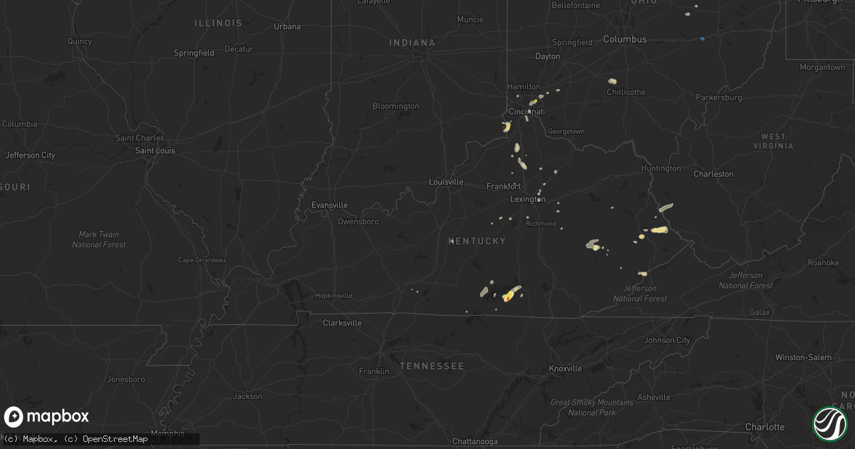
Hail Map in Kentucky on July 30, 2019
Get this storm
July 30 map
$229
one time, instant access
Download today. No call, no setup
Keep the $229
Bought the map and want the full workflow? Apply the entire $229 to a subscription within 7 days. None of it is wasted.
Every map, not just this one
This buys you this map. Subscription and you get every map we run, in the markets you choose from a few cities to whole states to nationwide. Plus real-time alerts the moment a storm fires.
Contact data
Name, contact info, occupancy, even credit band for addresses in the footprint. You go from where it hit to who to call.
Become the source they trust
Unlimited branding weather history reports on demand. You already have the documented answer ready for the property owner, and you are the one who showed up with it.
Property data and RoofTrace estimates
Pull up any address you have got, its value and the exact code rules for that jurisdiction, straight from One Click Code. Then RoofTrace estimates the squares, pitch, and roof value, priced the way you price.
Storm reports in Kentucky
Kentucky
| Date | Description |
|---|---|
| 07/30/20196:34 PM CDT | Police officer reported hail as large as golf balls. |
| 07/30/20192:52 PM CDT | Trees and wires down at waterworks road and taylor ave. Time estimated from radar. |
| 07/30/20192:52 PM CDT | Trees on road at 100 block covert run pike. Time estimated from radar. |
| 07/30/20192:50 PM CDT | Trees and wires down on 4th avenue. Time estimated from radar. |
| 07/30/20191:47 AM CDT | At 646 PM EDT, a severe thunderstorm was located over Arkansas, or 7 miles south of Prestonsburg, moving east at 15 mph. HAZARD...60 mph wind gusts and quarter size hail. SOURCE...Radar indicated. IMPACT...Hail damage to vehicles is expected. Expect wind damage to roofs, siding, and trees. Locations impacted include... Prestonsburg, Martin, Allen, Endicott, Bammer, Justell, Harold, Beaver Junction, Arkansas, Aluba, Dana and Betsy Layne. |
| 07/30/20191:36 AM CDT | At 635 PM EDT, a severe thunderstorm was located 13 miles north of Georgetown, moving south at 15 mph. HAZARD...60 mph wind gusts. SOURCE...Radar indicated. IMPACT...Expect damage to roofs, siding, and trees. Locations impacted include... Sadieville, Longlick, Skinnersburg, Mallard Point, Stonewall, Moon Lake Estates, Muddy Ford, Double Culvert, Biddle and Boydtown. |
| 07/29/201910:06 PM CDT | At 305 PM EDT, a severe thunderstorm was located near Helenwood, or 8 miles southwest of Oneida, moving northeast at 5 mph. HAZARD...60 mph wind gusts and nickel size hail. SOURCE...Radar indicated. IMPACT...Expect damage to roofs, siding, and trees. Locations impacted include... Oneida, Huntsville, Helenwood, Big South Fork National Park and Honey Creek State Park. |
| 07/29/20199:58 PM CDT | At 258 PM EDT, a severe thunderstorm was located over Elamton, or near West Liberty, moving east at 20 mph. HAZARD...60 mph wind gusts and quarter size hail. SOURCE...Radar indicated. IMPACT...Hail damage to vehicles is expected. Expect wind damage to roofs, siding, and trees. Locations impacted include... West Liberty, Lenox, Haleburg, Moon, Florress, Lick Branch, Logville, Jeptha, Williams, White Oak, Grayfox and Ever. |
All States Impacted by Hail Map on July 30, 2019
Cities Impacted by Hail Map on July 30, 2019
- Rozet, WY
- Gillette, WY
- Lance Creek, WY
- Jefferson, NY
- Davenport, NY
- Schenevus, NY
- Fallon, MT
- Terry, MT
- Ulster, PA
- Athens, PA
- Sayre, PA
- Milan, PA
- Kinder, LA
- Dry Creek, LA
- Sharpsburg, MD
- Keedysville, MD
- Miller Place, NY
- Rocky Point, NY
- Sound Beach, NY
- Upton, WY
- White House, TN
- Stevensville, MT
- Victor, MT
- Corvallis, MT
- Preble, NY
- Tully, NY
- La Fayette, NY
- Skaneateles, NY
- Marietta, NY
- Moravia, NY
- Huntingdon, PA
- Keyser, WV
- Monticello, KY
- Whitley City, KY
- Delhi, NY
- Meridale, NY
- East Meredith, NY
- Treadwell, NY
- Hanover, PA
- Brockway, MT
- Circle, MT
- Deadwood, SD
- Sturgis, SD
- Lead, SD
- Piedmont, SD
- Spearfish, SD
- Pikeville, KY
- Belfry, KY
- Varney, KY
- Sidney, KY
- Franklin, NY
- Moorcroft, WY
- Mount Pleasant, TN
- Dayton, TX
- Shenandoah Junction, WV
- Harpers Ferry, WV
- Lindsay, MT
- Delia, KS
- Silver Lake, KS
- Dayton, KY
- Newport, KY
- Bellevue, KY
- Fort Thomas, KY
- Fort Myers, FL
- Lehigh Acres, FL
- Houston, TX
- Seabrook, TX
- Baytown, TX
- La Porte, TX
- League City, TX
- Pasadena, TX
- Kemah, TX
- Devils Tower, WY
- Jasper, IN
- Hodgenville, KY
- Buffalo, KY
- Bristol, TN
- Mount Juliet, TN
- Beulah, WY
- Glasgow, MT
- Peerless, MT
- Ismay, MT
- Wilsondale, WV
- Fort Gay, WV
- Kermit, WV
- Dunlow, WV
- Crum, WV
- Bluff City, TN
- Booneville, KY
- Jackson, KY
- Owenton, KY
- Jacksonville, TX
- Marshall, VA
- Warrenton, VA
- Bacliff, TX
- Pearland, TX
- Webster, TX
- Alvin, TX
- Dickinson, TX
- Friendswood, TX
- Hill City, SD
- Elkhart, TX
- Grapeland, TX
- Luray, VA
- Rileyville, VA
- Vida, MT
- Fort Peck, MT
- Wolf Point, MT
- Richey, MT
- Glendive, MT
- Bloomfield, MT
- Hamilton, MT
- Sundance, WY
- Slanesville, WV
- Points, WV
- Lima, MT
- Spencer, ID
- Alpine, NY
- Newfield, NY
- Pittston, PA
- Scranton, PA
- Duryea, PA
- Old Forge, PA
- Taylor, PA
- Moosic, PA
- Wilkes Barre, PA
- Loxahatchee, FL
- McAlisterville, PA
- Vicco, KY
- Scuddy, KY
- Hot Springs, SD
- Willcox, AZ
- Harrison, NE
- Orlando, FL
- Edgemont, SD
- Buffalo Gap, SD
- Lake Placid, FL
- Dillsboro, IN
- Rising Sun, IN
- Aurora, IN
- Douglas, WY
- Georgetown, KY
- Richland, TX
- Towanda, PA
- Troy, PA
- Columbia Cross Roads, PA
- Cortland, NY
- Maysville, WV
- Devers, TX
- Millmont, PA
- Mifflinburg, PA
- Eglon, WV
- Oakland, MD
- Williamstown, KY
- Dry Ridge, KY
- Grundy, VA
- Lost Springs, WY
- Lusk, WY
- Manville, WY
- Scipio Center, NY
- Genoa, NY
- Aurora, NY
- King Ferry, NY
- Aladdin, WY
- Greenbrier, TN
- Bergton, VA
- Fulks Run, VA
- Criders, VA
- Auburn, KS
- Topeka, KS
- Wakarusa, KS
- Summerfield, FL
- Belleview, FL
- Darby, MT
- Newcastle, WY
- Custer, SD
- Mayking, KY
- Freeville, NY
- Ithaca, NY
- Pitkin, LA
- Clermont, FL
- Loveland, OH
- Morrow, OH
- Maineville, OH
- Alpharetta, GA
- Atlanta, GA
- Roswell, GA
- Marietta, GA
- Honesdale, PA
- Panther, WV
- Hurley, VA
- Lufkin, TX
- Burlington, KY
- Patriot, IN
- Union, KY
- Newton, TX
- Jenkins, KY
- Whitesburg, KY
- Pound, VA
- Worcester, NY
- Davenport Center, NY
- Beaumont, TX
- Homer, NY
- Little York, NY
- Sumterville, FL
- Wildwood, FL
- The Villages, FL
- Elkins, WV
- Rohrersville, MD
- Middletown, MD
- Allardt, TN
- Martin, KY
- Allen, KY
- Banner, KY
- Hague, NY
- Fort Valley, VA
- Oakwood, TX
- Granville Summit, PA
- Breeden, WV
- Warfield, KY
- Harts, WV
- Richfield, PA
- Mount Pleasant Mills, PA
- Island Park, ID
- Clarksburg, OH
- Scobey, MT
- Weston, WY
- Wells Tannery, PA
- Everett, PA
- Hopewell, PA
- Six Mile Run, PA
- Napier, WV
- Heaters, WV
- Flatwoods, WV
- Alliance, OH
- Oneonta, NY
- Liberty, TX
- Winston, MT
- Parsons, WV
- Hambleton, WV
- Alva, WY
- Antioch, TN
- Minden, IA
- Beloit, OH
- Mifflintown, PA
- Oakland Mills, PA
- Cumberland, MD
- Ridgeley, WV
- Wiley Ford, WV
- Fort Ashby, WV
- Prestonsburg, KY
- Mifflin, PA
- Port Royal, PA
- Pearce, AZ
- Havensville, KS
- Bowling Green, KY
- Ovid, NY
- West Yellowstone, MT
- McVeytown, PA
- Brogue, PA
- Felton, PA
- Red Lion, PA
- Stewartstown, PA
- Ooltewah, TN
- Scottsville, KY
- Murphy, NC
- Catawissa, PA
- Whitewood, SD
- Cameron, MT
- Newport, PA
- Woodworth, LA
- Boyce, LA
- Elmer, LA
- Jamesville, NY
- Manlius, NY
- Fayetteville, NY
- Troup, TX
- Sadieville, KY
- Corinth, KY
- Walton, NY
- Iuka, MS
- Cincinnati, OH
- Fort Lauderdale, FL
- Pembroke Pines, FL
- Hollywood, FL
- Ravenna, KY
- Irvine, KY
- Princeton, WV
- Pipestem, WV
- Dixie, WV
- Pond Gap, WV
- Lizemores, WV
- Montgomery, WV
- Hueysville, KY
- Eastern, KY
- Hankamer, TX
- Drummond, MT
- Hampton, AR
- Corsicana, TX
- Draper, VA
- Max Meadows, VA
- Galway, NY
- Ballston Spa, NY
- Frankfort, OH
- Salem, OH
- Charlotteville, NY
- Auburn, NY
- Nedrow, NY
- Interlaken, NY
- Romulus, NY
- Covington, KY
- Latonia, KY
- Karthaus, PA
- New Freedom, PA
- Burkesville, KY
- New Enterprise, PA
- Loysburg, PA
- Purdon, TX
- Hulett, WY
- Mathias, WV
- Milam, WV
- Moorefield, WV
- Broadway, VA
- Groveland, FL
- Russell Springs, KY
- Hugo, CO
- Jamestown, KY
- Albany, KY
- Flaxville, MT
- Wyoming, PA
- Kingston, PA
- Luzerne, PA
- Chavies, KY
- Greenfield Center, NY
- Middle Grove, NY
- Porter Corners, NY
- Chillicothe, OH
- Nicholasville, KY
- Elizabeth, WV
- Lost Creek, KY
- Waterloo, AL
- Savannah, TN
- Rusk, TX
- Ireland, WV
- Truxton, NY
- Jersey, AR
- Paris, KY
- Lexington, KY
- Nashua, MT
- De Ruyter, NY
- Paw Paw, WV
- Liverpool, PA
- West Liberty, KY
- Eustace, TX
- Hadley, NY
- Huntsville, TN
- Harrodsburg, KY
- Knoxville, MD
- Jefferson, MD
- Estero, FL
- Petersburg, PA
- Titusville, FL
- Mount Union, PA
- Palestine, TX
- Sebring, FL
- Inez, KY
- French Creek, WV
- Rock Cave, WV
- Coshocton, OH
- Rapid City, SD
- Damascus, PA
- Callicoon, NY
- Cochecton, NY
- Winchester, KY
- Front Royal, VA
- Ranger, WV
- Buffalo, TX
- Bloomville, NY
- Hampshire, TN
- Bushnell, FL
- Dryden, NY
- McGraw, NY
- Manheim, PA
- Palmyra, PA
- Elizabethtown, PA
- Lebanon, PA
- Burnside, KY
- Bronston, KY
- Ellamore, WV
- Carlisle, KY
- Bunnell, FL
- Lewisburg, PA
- Tellico Plains, TN
- Springfield, WV
- Oldtown, MD
- Purgitsville, WV
- Burlington, WV
- Warsaw, OH
- Cincinnatus, NY
- Stamping Ground, KY
- Deer Lodge, TN
- Mackville, KY
- Mabank, TX
- Pioneer, TN
- Louann, AR
- Gary, TX
- Mount Sterling, KY
- South Otselic, NY
- Georgetown, NY
- Flintstone, MD
- Shoreham, NY
- Conestoga, PA
- New Park, PA
- Airville, PA
- Gauley Bridge, WV
- Elk City, ID
- Montgomery, PA
- Bern, KS
- Dawson, TX
- Oxford, FL
- Bloomsburg, PA
- Bullard, TX
- Cynthiana, KY
- Blanchester, OH
- Clarksville, OH
- Montoursville, PA
- Muncy, PA
- Woodbury, PA
- Volborg, MT
- Woodland, PA
- Curwensville, PA
- Clearfield, PA
- Chattanooga, TN
- Brantingham, NY
- Turin, NY
- Glenfield, NY
- Eagle Bay, NY
- Lowville, NY
- Greenwich, NY
- Schaghticoke, NY
- Saranac Lake, NY
- Bayonne, NJ
- Jersey City, NJ
- Middleburg, PA
- Commerce City, CO
- Denver, CO
- Watkins, CO
- Aurora, CO
- Bennett, CO
- Nemo, SD
- Ellsworth Afb, SD
- New Underwood, SD
- Black Hawk, SD
- Caputa, SD
- Box Elder, SD
- Pine Ridge, SD
- Hermosa, SD
- Kyle, SD
- Wall, SD
- Scenic, SD
- Interior, SD
- Norwich, OH
- New Concord, OH
- Sharpsburg, GA
- Arlington, VT
- Shushan, NY
- Manchester Center, VT
- Bondville, VT
- Peru, VT
- Londonderry, VT
- Colchester, VT
- Fairfax, VT
- Jeffersonville, VT
- Underhill, VT
- Waterville, VT
- Fairfield, VT
- Westford, VT
- Shelburne, VT
- Willsboro, NY
- Winooski, VT
- Milton, VT
- Keeseville, NY
- Essex Junction, VT
- East Fairfield, VT
- Cambridge, VT
- Burlington, VT
- North Hero, VT
- Enosburg Falls, VT
- East Berkshire, VT
- North Troy, VT
- Montgomery Center, VT
- Richford, VT
- Franklin, VT
- Westfield, VT
- Mesa, AZ


