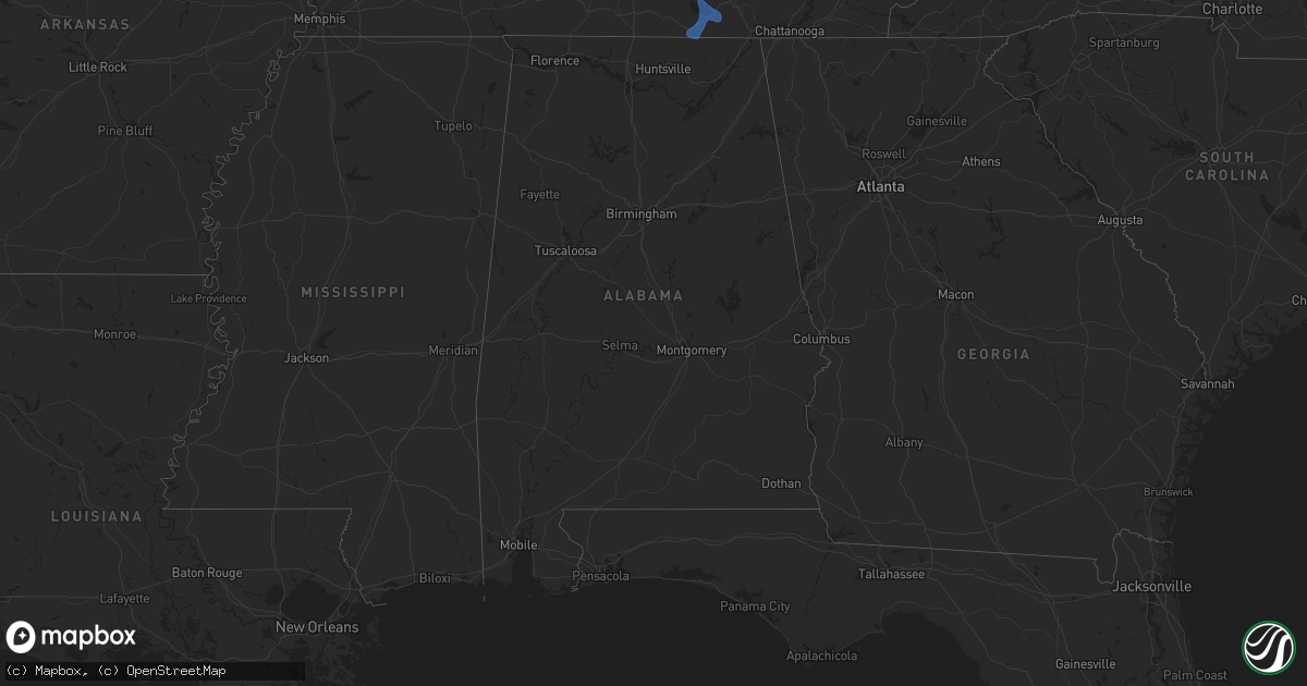
Hail Map in Alabama on July 29, 2024
Get this storm
July 29 map
$229
one time, instant access
Download today. No call, no setup
Keep the $229
Bought the map and want the full workflow? Apply the entire $229 to a subscription within 7 days. None of it is wasted.
Every map, not just this one
This buys you this map. Subscription and you get every map we run, in the markets you choose from a few cities to whole states to nationwide. Plus real-time alerts the moment a storm fires.
Contact data
Name, contact info, occupancy, even credit band for addresses in the footprint. You go from where it hit to who to call.
Become the source they trust
Unlimited branding weather history reports on demand. You already have the documented answer ready for the property owner, and you are the one who showed up with it.
Property data and RoofTrace estimates
Pull up any address you have got, its value and the exact code rules for that jurisdiction, straight from One Click Code. Then RoofTrace estimates the squares, pitch, and roof value, priced the way you price.
Storm reports in Alabama
Alabama
| Date | Description |
|---|---|
| 07/29/20245:52 PM CDT | A few trees blown down in the cedar bluff area. |
| 07/29/20245:47 PM CDT | 600 customers in dekalb county were reported without power in the sylvania and geraldine communities due to downed trees and powerlines. |
| 07/29/20245:29 PM CDT | Few trees down in the broomtown area. |
| 07/29/20245:02 PM CDT | 800 customers were reported without power across jackson county due to downed trees and powerlines. |
| 07/29/20244:54 PM CDT | A tree fell on a car on highway 75 just north of highway 40 near henagar. Thankfully... No injuries were reported. |
| 07/29/20244:50 PM CDT | One inch tree limbs broken off of trees and shingles blown off of a roof were reported at this location. M-ping report. |
| 07/29/20244:47 PM CDT | 200 customers were reported without power from flat rock to the south southwest of that location near the dekalb/jackson county line due to down trees and powerlines in |
| 07/29/20244:43 PM CDT | A tree was reported down at the intersection of moody ridge road and snodgrass road. |
| 07/29/20244:43 PM CDT | A tree was reported down at the intersection of windsor road and hood avenue. |
| 07/29/20244:35 PM CDT | One inch tree limbs were reported broken off of trees at this locations and some shingles were blown off of a roof. M-ping report. |
| 07/29/20244:33 PM CDT | A tree was reported down at the intersection of cr 237 and church street. |
All States Impacted by Hail Map on July 29, 2024
Cities Impacted by Hail Map on July 29, 2024
- McDonald, KS
- Levant, KS
- Colby, KS
- Atwood, KS
- Gem, KS
- Rexford, KS
- Selden, KS
- Hoxie, KS
- Park, KS
- Ellis, KS
- Hays, KS
- Victoria, KS
- Pfeifer, KS
- Walker, KS
- Bison, KS
- Gorham, KS
- Russell, KS
- Otis, KS
- Hoisington, KS
- Olmitz, KS
- Bunker Hill, KS
- Dorrance, KS
- Wilson, KS
- Bloomfield, NE
- Crofton, NE
- Wagner, SD
- Lake Andes, SD
- Dante, SD
- Hartington, NE
- Wausa, NE
- Randolph, NE
- Coleridge, NE
- Niobrara, NE
- Center, NE
- Rosalie, NE
- Lyons, NE
- Decatur, NE
- Mclean, NE
- Kennebec, SD
- Reliance, SD
- Gregory, SD
- Platte, SD
- Butte, NE
- Spencer, NE
- Bristow, NE
- Sac City, IA
- Barnard, KS
- Lincoln, KS
- Grafton, IL
- Brussels, IL
- Hunter, KS
- Sylvan Grove, KS
- Portage Des Sioux, MO
- Gypsum, KS
- Hope, KS
- Osborne, KS
- Downs, KS
- Durham, KS
- Tampa, KS
- Pinckneyville, IL
- Natoma, KS
- Tipton, KS
- Waldo, KS
- Estill Springs, TN
- Winchester, TN
- Belvidere, TN
- Tullahoma, TN
- Lynchburg, TN
- Decherd, TN
- Cowan, TN
- Huntland, TN
- Elora, TN
- Estillfork, AL
- Philip, SD
- Midland, SD
- Dunn Center, ND
- Halliday, ND
- Killdeer, ND
- Roseglen, ND
- Beulah, ND
- Garrison, ND
- Zap, ND
- Golden Valley, ND
- Stanton, ND
- Hazen, ND
- Ryder, ND
- Parshall, ND
- Mandan, ND
- Belvidere, SD
- Fort Pierre, SD
- Bismarck, ND
- Plaza, ND
- Okaton, SD
- Baldwin, ND
- Murdo, SD
- Draper, SD
- Saint Francis, SD
- White River, SD
- Wood, SD
- Menoken, ND
- Kadoka, SD
- Presho, SD
- Mission, SD
- Valentine, NE
- Sterling, ND
- Ideal, SD
- Winner, SD
- Witten, SD
- Moffit, ND
- Kulm, ND
- Edgeley, ND
- Sparks, NE
- Springview, NE
- Colome, SD
- Dallas, SD
- Wood Lake, NE
- Anderson, IN
- Frankton, IN
- Mercer, ND
- Mcclusky, ND
- Selfridge, ND
- Strasburg, ND
- Fort Yates, ND
- Solen, ND
- Linton, ND
- McLaughlin, SD
- Wakpala, SD
- Glenham, SD
- Mound City, SD
- Herreid, SD
- Pollock, SD
- Eureka, SD
- Java, SD
- Hague, ND
- Zeeland, ND
- Long Lake, SD
- Cannon Ball, ND
- Ashley, ND
- Leola, SD
- Wishek, ND
- Hazelton, ND
- Braddock, ND
- Napoleon, ND
- Kintyre, ND
- Lehr, ND
- Fredonia, ND
- Tappen, ND
- Gackle, ND
- Cleveland, ND
- Jud, ND
- Streeter, ND
- White Lake, SD
- Stickney, SD
- Harrison, SD
- Plankinton, SD
- Corsica, SD
- New Holland, SD
- Armour, SD
- Mount Vernon, SD
- Parkston, SD
- Dimock, SD
- Delmont, SD
- Tripp, SD
- Olivet, SD
- Tyndall, SD
- Avon, SD
- Scotland, SD
- Kaylor, SD
- Forbes, ND
- Montpelier, ND
- Jamestown, ND
- Mills, NE
- Ellendale, ND
- Westport, SD
- Frederick, SD
- Fullerton, ND
- Berlin, ND
- Lesterville, SD
- Freeman, SD
- Menno, SD
- Emery, SD
- Utica, SD
- Hurley, SD
- Parker, SD
- Marion, SD
- Irene, SD
- Viborg, SD
- Centerville, SD
- Davis, SD
- Mission Hill, SD
- Volin, SD
- Yankton, SD
- Fordyce, NE
- Laurel, NE
- Dixon, NE
- Allen, NE
- Wynot, NE
- Newcastle, NE
- Maskell, NE
- Ponca, NE
- Jackson, NE
- Waterbury, NE
- Emerson, NE
- Hubbard, NE
- South Sioux City, NE
- Jefferson, SD
- Dakota City, NE
- Salix, IA
- Elk Point, SD
- Homer, NE
- Sergeant Bluff, IA
- Sioux City, IA
- North Sioux City, SD
- Oakes, ND
- Lamoure, ND
- Gwinner, ND
- Verona, ND
- Dickey, ND
- Marion, ND
- Hornick, IA
- Lawton, IA
- Bronson, IA
- Sloan, IA
- Burbank, SD
- Merrill, IA
- Westfield, IA
- Hinton, IA
- Akron, IA
- Le Mars, IA
- Moville, IA
- Kingsley, IA
- Blanchester, OH
- Climbing Hill, IA
- Anthon, IA
- Remsen, IA
- Pender, NE
- Thurston, NE
- Walthill, NE
- Winnebago, NE
- Macy, NE
- Bancroft, NE
- Onawa, IA
- Whiting, IA
- Oakland, NE
- Tekamah, NE
- Little Sioux, IA
- Craig, NE
- Blencoe, IA
- Correctionville, IA
- Washta, IA
- Oto, IA
- Pierson, IA
- Smithland, IA
- Mondamin, IA
- Rodney, IA
- Battle Creek, IA
- Castana, IA
- Mapleton, IA
- Soldier, IA
- Moorhead, IA
- Pisgah, IA
- Cushing, IA
- Danbury, IA
- Ute, IA
- Holstein, IA
- Ida Grove, IA
- Charter Oak, IA
- Arthur, IA
- Dunlap, IA
- Deloit, IA
- Wall Lake, IA
- Odebolt, IA
- Dow City, IA
- Ricketts, IA
- Kiron, IA
- Woodbine, IA
- Schleswig, IA
- Denison, IA
- Breda, IA
- Carroll, IA
- Auburn, IA
- Arcadia, IA
- Arion, IA
- Westside, IA
- Lake View, IA
- Vail, IA
- Lake City, IA
- Rockwell City, IA
- Glidden, IA
- Lohrville, IA
- Logan, IA
- Lanesboro, IA
- Templeton, IA
- Farnhamville, IA
- Westphalia, IA
- Lidderdale, IA
- Earling, IA
- Modale, IA
- Magnolia, IA
- Halbur, IA
- Harlan, IA
- Missouri Valley, IA
- Churdan, IA
- Defiance, IA
- Persia, IA
- Portsmouth, IA
- Aspinwall, IA
- Kirkman, IA
- Shelby, IA
- Panama, IA
- Neola, IA
- Irwin, IA
- Manilla, IA
- Manning, IA
- Adair, IA
- Gray, IA
- Ralston, IA
- Brayton, IA
- Atlantic, IA
- Audubon, IA
- Marne, IA
- Dedham, IA
- Exira, IA
- Kimballton, IA
- Coon Rapids, IA
- Bayard, IA
- Avoca, IA
- Walnut, IA
- Guthrie Center, IA
- Scranton, IA
- Hamlin, IA
- Elk Horn, IA
- Bagley, IA
- Jefferson, IA
- Panora, IA
- Yale, IA
- Jamaica, IA
- Rippey, IA
- Dana, IA
- Paton, IA
- Gowrie, IA
- Grand Junction, IA
- Dawson, IA
- Anita, IA
- Casey, IA
- Menlo, IA
- Redfield, IA
- Stuart, IA
- Adel, IA
- Waukee, IA
- Perry, IA
- Minburn, IA
- Dallas Center, IA
- Linden, IA
- West Des Moines, IA
- Madrid, IA
- Bouton, IA
- Granger, IA
- Urbandale, IA
- Ogden, IA
- Boone, IA
- Grimes, IA
- Woodward, IA
- Clive, IA
- Pilot Mound, IA
- Beaver, IA
- Stratford, IA
- Dayton, IA
- Harcourt, IA
- Boxholm, IA
- Des Moines, IA
- Huxley, IA
- Kelley, IA
- Elkhart, IA
- Ames, IA
- Johnston, IA
- Slater, IA
- Alleman, IA
- Sheldahl, IA
- Cambridge, IA
- Polk City, IA
- Luther, IA
- Ankeny, IA
- Mitchellville, IA
- Carlisle, IA
- Mingo, IA
- Runnells, IA
- Pleasant Hill, IA
- Norwalk, IA
- Altoona, IA
- Windsor Heights, IA
- Colfax, IA
- Cumming, IA
- Van Meter, IA
- Indianola, IA
- Prole, IA
- Bondurant, IA
- Maxwell, IA
- Berwick, IA
- Prairie City, IA
- Swan, IA
- Knoxville, IA
- Pleasantville, IA
- Otley, IA
- Monroe, IA
- Hartford, IA
- Milo, IA
- Ackworth, IA
- Pella, IA
- Chariton, IA
- Harvey, IA
- Tracy, IA
- Melcher Dallas, IA
- Hamilton, IA
- Lovilia, IA
- Columbia, IA
- Bussey, IA
- Lacona, IA
- Reasnor, IA
- Oskaloosa, IA
- Leighton, IA
- Beacon, IA
- Eddyville, IA
- Collins, IA
- Newton, IA
- Nevada, IA
- Russell, IA
- Albia, IA
- Melrose, IA
- Williamson, IA
- Liberty Center, IA
- Lucas, IA
- Plano, IA
- Promise City, IA
- Moravia, IA
- New Sharon, IA
- University Park, IA
- Sully, IA
- Mystic, IA
- Centerville, IA
- Exline, IA
- Udell, IA
- Moulton, IA
- Ottumwa, IA
- Blakesburg, IA
- Cedar, IA
- Unionville, IA
- Chillicothe, IA
- Fremont, IA
- Bloomfield, IA
- Kirkville, IA
- Drakesville, IA
- Hedrick, IA
- Agency, IA
- Fairfield, IA
- Batavia, IA
- Eldon, IA
- Packwood, IA
- Memphis, MO
- Selma, IA
- Floris, IA
- Libertyville, IA
- Downing, MO
- Pulaski, IA
- North Clarendon, VT
- Rutland, VT
- Flemingsburg, KY
- Mayslick, KY
- Ewing, KY
- Tollesboro, KY
- Maysville, KY
- Wallingford, KY
- Cuttingsville, VT
- Milton, IA
- Cantril, IA
- Douds, IA
- Lancaster, MO
- Arbela, MO
- Stockport, IA
- Brighton, IA
- Mount Pleasant, IA
- Keosauqua, IA
- Lockridge, IA
- Birmingham, IA
- Mount Sterling, IA
- Martinsburg, IA
- Vandalia, IL
- Ramsey, IL
- Shobonier, IL
- Sandoval, IL
- Vernon, IL
- Alma, IL
- Iuka, IL
- Mount Vernon, IL
- Texico, IL
- Mulberry Grove, IL
- Fillmore, IL
- Kell, IL
- Dix, IL
- Salem, IL
- Bluford, IL
- Patoka, IL
- Odin, IL
- Hillsboro, IA
- Salem, IA
- Donnellson, IA
- Farmington, IA
- Gorin, MO
- West Point, IA
- Wayland, MO
- Wyaconda, MO
- Kahoka, MO
- Revere, MO
- Saint Paul, IA
- Bonaparte, IA
- Luray, MO
- Argyle, IA
- Gladstone, IL
- Middletown, IA
- West Burlington, IA
- New London, IA
- Burlington, IA
- Danville, IA
- Keokuk, IA
- Montrose, IA
- Hamilton, IL
- Fort Madison, IA
- Alexandria, MO
- Denmark, IA
- Saint Patrick, MO
- Carman, IL
- Wever, IA
- Dallas City, IL
- Niota, IL
- Nauvoo, IL
- Sciota, IL
- Carthage, IL
- Roseville, IL
- Raritan, IL
- Lomax, IL
- La Harpe, IL
- Good Hope, IL
- Media, IL
- Blandinsville, IL
- Stronghurst, IL
- Macomb, IL
- Basco, IL
- Warsaw, IL
- Elvaston, IL
- Tennessee, IL
- Colchester, IL
- Plymouth, IL
- Industry, IL
- Bushnell, IL
- Deer Creek, MN
- Henning, MN
- Ottertail, MN
- Littleton, IL
- Rushville, IL
- Frederick, IL
- Beardstown, IL
- Camden, IL
- Augusta, IL
- Lewistown, IL
- Bardolph, IL
- Table Grove, IL
- Smithfield, IL
- Adair, IL
- Ipava, IL
- Marietta, IL
- Smithshire, IL
- Cuba, IL
- Vermont, IL
- Astoria, IL
- Browning, IL
- Bath, IL
- Kimball, SD
- Wessington Springs, SD
- Chandlerville, IL
- Virginia, IL
- Havana, IL
- Liverpool, IL
- Ethan, SD
- Granville, IA
- Marcus, IA
- Mott, ND
- Regent, ND
- Dawson, ND
- Steele, ND
- Rock Valley, IA
- Hawarden, IA
- Meriden, IA
- New Salem, ND
- Center, ND
- Preston, GA
- Marissa, IL
- Lenzburg, IL
- Mascoutah, IL
- Solomon, KS
- Bennington, KS
- Abilene, KS
- Minneapolis, KS
- Naper, NE
- Brazil, IN
- Centerpoint, IN
- New Douglas, IL
- Pocahontas, IL
- Highland, IL
- Alhambra, IL
- Burlington, ND
- Minot, ND
- Makoti, ND
- Des Lacs, ND
- Salem, SD
- Montrose, SD
- Lafayette, AL
- Bunker Hill, IL
- Worden, IL
- Dorsey, IL
- Fergus Falls, MN
- Parkers Prairie, MN
- New Market, AL
- Hazel Green, AL
- Huntsville, AL
- Collinsville, IL
- Troy, IL
- Hancock, MN
- Starbuck, MN
- Cyrus, MN
- Glenwood, MN
- Brooten, MN
- Smithboro, IL
- Sorento, IL
- Greenville, IL
- Donnellson, IL
- Kinmundy, IL
- Raywick, KY
- West Rutland, VT
- Ireton, IA
- Maurice, IA
- Eagle Butte, SD
- Staples, MN
- Lantry, SD
- Huron, SD
- Eagle Bend, MN
- Miltona, MN
- Prattville, AL
- Talbotton, GA
- Junction City, GA
- Hayes, SD
- Fitzgerald, GA
- Abbeville, GA
- Rhine, GA
- Coal City, IN
- Clay City, IN
- Timber Lake, SD
- Benton, IL
- Bowling Green, IN
- Freedom, IN
- Rothsay, MN
- Lewisburg, TN
- Sioux Center, IA
- Forman, ND
- Shelbyville, TN
- Essex, MD
- Rosedale, MD
- Middle River, MD
- Nottingham, MD
- Baltimore, MD
- Dupree, SD
- Hamill, SD
- Brookville, IN
- Cedar Grove, IN
- Billingsley, AL
- Ainsworth, NE
- Ambrose, GA
- Columbiana, AL
- Wilsonville, AL
- Marine, IL
- Edwardsville, IL
- Bethalto, IL
- Alton, IL
- Cogswell, ND
- Enning, SD
- Canistota, SD
- Beresford, SD
- Spencer, SD
- Alexandria, SD
- Bison, SD
- Meadow, SD
- Hoyleton, IL
- Lynch, NE
- Taylorville, IL
- Blakely, GA
- Alton, IA
- Hull, IA
- Milesville, SD
- Central, IN
- Mauckport, IN
- Corydon, IN
- Battletown, KY
- Lenox, GA
- Hillsboro, IL
- Irving, IL
- Witt, IL
- Bingham, IL
- Wolsey, SD
- Pukwana, SD
- Fort Thompson, SD
- Gann Valley, SD
- Boston, KY
- Lebanon Junction, KY
- Lower Brule, SD
- Chamberlain, SD
- Baileyton, AL
- Butler, IL
- Litchfield, IL
- Laurel, IN
- Rushville, IN
- New Leipzig, ND
- Washburn, ND
- Winfred, SD
- Howard, SD
- Canova, SD
- Bertha, MN
- Paoli, IN
- English, IN
- French Lick, IN
- Hamilton, GA
- Fayetteville, TN
- Kelso, TN
- Bristow, IN
- Ferdinand, IN
- Birdseye, IN
- Wray, GA
- Andover, SD
- Pierpont, SD
- Worthington, IN
- Dawson, GA
- Leopold, IN
- Cannelton, IN
- Branchville, IN
- Leavenworth, IN
- Elizabethtown, KY
- Lemmon, SD
- Crookston, NE
- Glen Carbon, IL
- Maryville, IL
- Okeana, OH
- Hamilton, OH
- Oxford, OH
- Staunton, IN
- Lewis, IN
- Jasonville, IN
- Delphos, KS
- Glasco, KS
- Keldron, SD
- Coffeen, IL
- Nokomis, IL
- Brownstown, IL
- Walshville, IL
- Plantersville, AL
- Cherry Creek, SD
- Sigourney, IA
- Metamora, IN
- Coulterville, IL
- Tilden, IL
- Freeburg, IL
- Milan, GA
- Scheller, IL
- Brooklyn, MD
- Halethorpe, MD
- Bloomington, IN
- Springville, IN
- Lennox, SD
- Humboldt, SD
- Hartford, SD
- Centerville, IN
- Cambridge City, IN
- Milton, IN
- Cusseta, GA
- Hamel, IL
- Caseyville, IL
- Fairview Heights, IL
- O'Fallon, IL
- Muldraugh, KY
- Shepherdsville, KY
- Bardstown, KY
- Coxs Creek, KY
- Louisville, KY
- Clermont, KY
- Brandenburg, KY
- Elizabeth, IN
- West Point, KY
- Laconia, IN
- Browerville, MN
- Norris City, IL
- Carmi, IL
- Marengo, IN
- Hardinsburg, IN
- Spencer, IN
- Kingston, GA
- Cartersville, GA
- Carthage, SD
- Culloden, GA
- Musella, GA
- Donalsonville, GA
- Campbellsville, KY
- Bridgewater, SD
- Lidgerwood, ND
- New York Mills, MN
- Alpena, SD
- Cavour, SD
- Iroquois, SD
- Heltonville, IN
- Bedford, IN
- Bisbee, AZ
- Omaha, IL
- Wessington, SD
- Richland, IA
- Opelika, AL
- Auburn, AL
- Tuskegee, AL
- Orange City, IA
- Vining, MN
- Avoca, IN
- Norman, IN
- Oolitic, IN
- Bartelso, IL
- Centralia, IL
- Carlyle, IL
- Staunton, IL
- Ashley, IL
- Moro, IL
- Germantown, IL
- Richview, IL
- Breese, IL
- Okawville, IL
- Hoffman, IL
- Livingston, IL
- Nashville, IL
- Beckemeyer, IL
- Brighton, IL
- Aviston, IL
- Prairie City, SD
- Enfield, IL
- Perry, GA
- Sparks, GA
- Lebanon, KY
- Loretto, KY
- Taft, TN
- New Castle, IN
- Isabel, SD
- Reva, SD
- Nashville, IN
- Mulberry, TN
- Long Pine, NE
- Castleberry, AL
- Evergreen, AL
- Straughn, IN
- Waltonville, IL
- Sesser, IL
- Fort Valley, GA
- Saint Anthony, IN
- Daviston, AL
- Canton, SD
- Waverly Hall, GA
- Shiloh, GA
- Dallas, GA
- Pickens, SC
- Sunset, SC
- Parkville, MD
- Westville, FL
- Worthing, SD
- Clarissa, MN
- Shelburn, IN
- Sullivan, IN
- Bloomfield, IN
- Hanover, MD
- Fort George G Meade, MD
- Jessup, MD
- Severn, MD
- Brewton, AL
- Waubay, SD
- Harvel, IL
- Raymond, IL
- Morristown, SD
- Buena Vista, GA
- Harrisburg, SD
- Claire City, SD
- Rosamond, IL
- Pana, IL
- Tamaroa, IL
- Mulkeytown, IL
- Mableton, GA
- Austell, GA
- Fort Benning, GA
- Gettysburg, SD
- Sabetha, KS
- Inwood, IA
- Motley, MN
- Scott Air Force Base, IL
- Belleville, IL
- Arcadia, IN
- Atlanta, IN
- Sylacauga, AL
- Oconee, IL
- Owaneco, IL
- Palmer, IL
- Morrisonville, IL
- Lithia Springs, GA
- Douglasville, GA
- Larchwood, IA
- Hartford, IL
- Granite City, IL
- South Roxana, IL
- East Alton, IL
- Roxana, IL
- Wood River, IL
- Normandy, TN
- Wartrace, TN
- Parrott, GA
- Liberty, IN
- Richmond, IN
- Yatesville, GA
- Morrow, OH
- Midland, OH
- Pleasant Plain, OH
- Clarksville, OH
- Hazlehurst, GA
- Fairmount, ND
- Du Bois, IL
- Richland, GA
- Gambrills, MD
- Annapolis Junction, MD
- Odenton, MD
- Shelby, AL
- Wadena, MN
- Huntingburg, IN
- Holland, IN
- Dalhart, TX
- Flintville, TN
- Bullhead, SD
- Cherokee, IA
- Marbury, AL
- Deatsville, AL
- Mauk, GA
- Artesian, SD
- New England, ND
- Murfreesboro, TN
- Evansville, IN
- Chandler, IN
- Newburgh, IN


