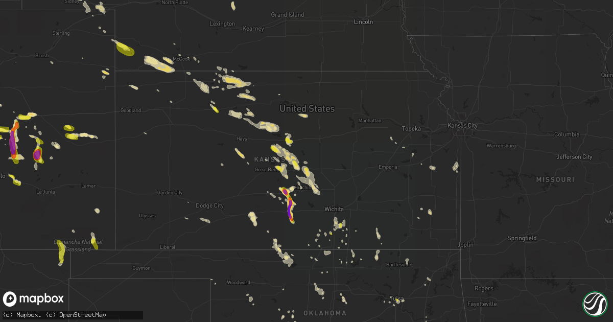
Hail Map in Kansas on July 28, 2016
Get this storm
July 28 map
$229
one time, instant access
Download today. No call, no setup
Keep the $229
Bought the map and want the full workflow? Apply the entire $229 to a subscription within 7 days. None of it is wasted.
Every map, not just this one
This buys you this map. Subscription and you get every map we run, in the markets you choose from a few cities to whole states to nationwide. Plus real-time alerts the moment a storm fires.
Contact data
Name, contact info, occupancy, even credit band for addresses in the footprint. You go from where it hit to who to call.
Become the source they trust
Unlimited branding weather history reports on demand. You already have the documented answer ready for the property owner, and you are the one who showed up with it.
Property data and RoofTrace estimates
Pull up any address you have got, its value and the exact code rules for that jurisdiction, straight from One Click Code. Then RoofTrace estimates the squares, pitch, and roof value, priced the way you price.
Storm reports in Kansas
Kansas
| Date | Description |
|---|---|
| 07/28/20166:53 PM CDT | Estimated 60mph winds...corrected for time. |
| 07/28/20166:50 PM CDT | Delayed report. |
| 07/28/20166:40 PM CDT | Estimated 60mph winds. |
| 07/28/20166:40 PM CDT | Estimated 60mph winds |
| 07/28/20166:23 PM CDT | Reported at ellsworth airport...corrected for time. |
| 07/28/20166:22 PM CDT | A local report indicates 73 MPH wind near CONCORDIA AIRPORT |
| 07/28/20166:22 PM CDT | 18 inch diameter tree snapped and numerous 3-5 inch diameter limbs are down. |
| 07/28/20166:12 PM CDT | Estimated 70-80 mph wind gusts. Tree damage unknown. |
| 07/28/20166:09 PM CDT | Sustained 55 mph with gusts to 70 mph... Possibly higher. |
| 07/28/20165:54 PM CDT | A local report indicates 62 MPH wind near SMITH CENTER AIRPORT |
| 07/28/20165:47 PM CDT | This is a new peak gust associated with the back-side of the storm. Update to original report includes law enforcement reporting trees down in town. |
| 07/28/20165:45 PM CDT | 6 inch diameter healthy tree branch down in beloit. Report and photo via social media. |
| 07/28/20165:43 PM CDT | Personal mesonet station. Exact time estimated from radar as it occurred between 5-minute obs |
| 07/28/20165:40 PM CDT | Reported at ellsworth airport |
| 07/28/20165:40 PM CDT | Estimated 60mph winds with some tree limbs down. |
| 07/28/20165:11 PM CDT | A local report indicates 60 MPH wind near 2 SW ALTON |
| 07/28/20165:10 PM CDT | A local report indicates 71 MPH wind near SMITH CENTER AIRPORT |
| 07/28/20164:55 PM CDT | Reports of tree branches and possibly trees down in athol. Time estimated from radar. |
| 07/28/20164:55 PM CDT | A local report indicates 60 MPH wind near 1 N KENSINGTON |
| 07/28/20164:40 PM CDT | A local report indicates 60 MPH wind near 6 E PHILLIPSBURG |
| 07/28/20164:40 PM CDT | County storm spotters report several trees up to 12 inches in diameter were snapped with the storm and 1 business lost part of its roof with the storm. Pea size hail wa |
| 07/28/20164:34 PM CDT | Pea size hail |
| 07/28/20164:30 PM CDT | Time estimated from radar. |
| 07/28/20164:26 PM CDT | Sarrada farms mesonet in logan. |
| 07/28/20164:20 PM CDT | Time estimated from radar |
| 07/28/20164:15 PM CDT | Estimated 60 mph or higher wind gusts. A grain bin in construction was blown over. |
| 07/28/20164:06 PM CDT | A local report indicates 58 MPH wind near NORTON |
| 07/28/20164:00 PM CDT | Power lines reported down in town. |
| 07/28/20163:56 PM CDT | Tree damage reported on the north side of town. |
| 07/28/20163:55 PM CDT | There were multiple reports of limbs and trees downed. This is a correction of the report issued at 355 pm cdt. |
| 07/28/20163:41 PM CDT | A local report indicates 61 MPH wind near STROTHER FIELD AIRPORT |
| 07/28/20163:41 PM CDT | Hail was nickel to quarter size. |
| 07/28/20163:28 PM CDT | A local report indicates 62 MPH wind near OBERLIN |
| 07/28/201610:00 AM CDT | Observer reported that a tree fell onto a roof of a home in erie. |
| 07/27/20169:15 PM CDT | Large tree downed in town. |
| 07/27/20169:08 PM CDT | A local report indicates 65 MPH wind near 2 NNW EL DORADO |
| 07/27/20168:56 PM CDT | 1 to 2 inch diameter limbs down. Estimates 50 mph wind gust. |
| 07/27/20168:43 PM CDT | A local report indicates 78 MPH wind near 2 N EAST WICHITA |
| 07/27/20168:41 PM CDT | Power pole snapped. |
| 07/27/20168:34 PM CDT | 50 to 60 mph winds. |
| 07/27/20168:32 PM CDT | Half a bradford pear tree broken off. |
| 07/27/20168:30 PM CDT | A local report indicates 70 MPH wind near 1 NE NORWICH |
| 07/27/20168:28 PM CDT | Near 119th and 21st. |
| 07/27/20168:28 PM CDT | A local report indicates 65 MPH wind near ANDALE |
| 07/27/20168:28 PM CDT | Large tree limbs down near 21st and tyler. Report via twitter. |
| 07/27/20168:24 PM CDT | 75-85 mph winds were reported on nw 21st street between tyler and maize roads. |
| 07/27/20168:23 PM CDT | A local report indicates 61 MPH wind near WICHITA EISENHOWER NATL |
| 07/27/20168:20 PM CDT | Large tree blown down. Via twitter. |
| 07/27/20168:20 PM CDT | A local report indicates 65 MPH wind near MAIZE |
| 07/27/20168:19 PM CDT | A local report indicates 65 MPH wind near MOUNT HOPE |
| 07/27/20168:15 PM CDT | Several large branches down across town. Trees twisted and split. Estimated 85 mph winds. Delayed report. |
| 07/27/20168:10 PM CDT | Several large limbs down across town. |
| 07/27/20168:05 PM CDT | Multiple 12 inch three limbs down. |
| 07/27/20168:05 PM CDT | A local report indicates 78 MPH wind near MOUNT HOPE |
| 07/27/20168:04 PM CDT | 65 to 70 mph. |
| 07/27/20167:55 PM CDT | Ping pong to tennis ball hail. |
| 07/27/20167:55 PM CDT | Delayed report of a 4-5 inch diameter tree limb snapped. Picture and report via twitter. |
| 07/27/20167:42 PM CDT | Estimated 60mph winds. |
| 07/27/20167:35 PM CDT | A local report indicates 60 MPH wind near HUTCHINSON |
| 07/27/20167:30 PM CDT | A local report indicates 60 MPH wind near NNW JUNCTION CITY |
| 07/27/20167:27 PM CDT | 50-60 mph wind gusts |
| 07/27/20167:26 PM CDT | A local report indicates 60 MPH wind near MCPHERSON |
| 07/27/20167:25 PM CDT | 60 to 70 mph. Pea size hail also reported. |
| 07/27/20167:24 PM CDT | 2 foot diameter tree blown over. Golf cart picked up and blown into a field. |
| 07/27/20167:19 PM CDT | Estimated 60mph wind gust. |
| 07/27/20167:14 PM CDT | A local report indicates 2.00 inch wind near SYLVIA |
| 07/27/20167:12 PM CDT | A local report indicates 1.75 inch wind near SYLVIA |
All States Impacted by Hail Map on July 28, 2016
Cities Impacted by Hail Map on July 28, 2016
- Watonga, OK
- Claflin, KS
- Wilson, KS
- Bunker Hill, KS
- Dorrance, KS
- Hoisington, KS
- Bayard, NE
- Minatare, NE
- Medicine Lodge, KS
- Lake City, KS
- Judsonia, AR
- Birch Tree, MO
- Luray, KS
- Lucas, KS
- Winfield, KS
- Ramah, CO
- Beloit, KS
- Raymond, KS
- Alden, KS
- Kirkland, AZ
- Peyton, CO
- Newkirk, OK
- Ellinwood, KS
- Chase, KS
- Bushton, KS
- Nowata, OK
- Delaware, OK
- Fowler, KS
- Minneola, KS
- Eskridge, KS
- Heathsville, VA
- Lancaster, VA
- Mutual, OK
- Vici, OK
- Reedville, VA
- Winn, ME
- Lee, ME
- Burlington, ME
- Lincoln, ME
- Springfield, ME
- Pawhuska, OK
- Paradise, KS
- Waldo, KS
- Colorado Springs, CO
- Matheson, CO
- Limon, CO
- Agate, CO
- Flagler, CO
- Dunnsville, VA
- Boone, CO
- Fowler, CO
- Lusk, WY
- Franklin Grove, IL
- La Cygne, KS
- Mattawamkeag, ME
- Wytopitlock, ME
- Kingman, ME
- Millinocket, ME
- Brownville, ME
- Senath, MO
- West Enfield, ME
- Calhan, CO
- Culbertson, NE
- Williamsburg, KS
- White Marsh, MD
- Middle River, MD
- Wagon Mound, NM
- Stratton, NE
- Benkelman, NE
- Max, NE
- Ellsworth, KS
- Sylvan Grove, KS
- Coatesville, PA
- Mitchell, NE
- Scottsbluff, NE
- Harrison, NE
- Bloomington, IL
- Downs, IL
- Cheyenne, WY
- Polo, IL
- Arlington, IL
- Easton, ME
- Mapleton, ME
- Presque Isle, ME
- Sylvia, KS
- Cherokee, OK
- Little River, KS
- Inman, KS
- Lyons, KS
- Windom, KS
- Simla, CO
- Kit Carson, CO
- Chestertown, MD
- Lake Geneva, WI
- Burlington, WI
- Elkhorn, WI
- Springfield, WI
- Delavan, WI
- Adair, OK
- Big Cabin, OK
- West Chester, PA
- Kennett Square, PA
- Tappahannock, VA
- Le Roy, IL
- Cunningham, KS
- Burlington, OK
- Alva, OK
- Trenton, NE
- Ponca City, OK
- Julesburg, CO
- Ovid, CO
- Chappell, NE
- Fountain, CO
- Saint Inigoes, MD
- Ridge, MD
- Scotland, MD
- Dameron, MD
- Ingalls, KS
- Geneva, IL
- Buhler, KS
- Burrton, KS
- Hutchinson, KS
- Madison Heights, VA
- Elbert, CO
- Woodston, KS
- Albany, TX
- Turon, KS
- Lorraine, KS
- Geneseo, KS
- Erie, KS
- Wray, CO
- Ordway, CO
- Rush, CO
- Couch, MO
- Myrtle, MO
- Yoder, CO
- Shawnee, WY
- Maywood, NE
- Sedgwick, CO
- Abilene, TX
- Cowden, IL
- Stillwater, OK
- Spivey, KS
- Kingman, KS
- Arlington, KS
- Dalton, NE
- Mcgrew, NE
- Bridgeport, NE
- Harrisburg, NE
- Alliance, NE
- Lusby, MD
- Ansley, NE
- Mason City, NE
- Westerville, NE
- Tulsa, OK
- Vernon, CO
- Littleton, CO
- Denver, CO
- Golden, CO
- McCracken, KS
- La Crosse, KS
- Virginia Beach, VA
- Mulvane, KS
- Udall, KS
- Belle Plaine, KS
- Stockton, KS
- Kirwin, KS
- Phillipsburg, KS
- Glade, KS
- Logan, KS
- Young, AZ
- Cedar Vale, KS
- Grenola, KS
- Dover, DE
- Magnolia, DE
- Dover Afb, DE
- Camden Wyoming, DE
- Cheswold, DE
- Hartly, DE
- Plainville, KS
- Stafford, KS
- Bridgeville, DE
- Ellendale, DE
- Georgetown, DE
- Seaford, DE
- Greenwood, DE
- Concord, VA
- Appomattox, VA
- Spout Spring, VA
- Berlin, MD
- Goode, VA
- Utopia, TX
- Muskogee, OK
- Holyoke, CO
- Palco, KS
- Damar, KS
- Fredericksburg, VA
- Spotsylvania, VA
- Natoma, KS
- Prairie View, KS
- Lenora, KS
- Agra, KS
- Almena, KS
- Long Island, KS
- Marshall, OK
- Braman, OK
- Medford, OK
- Dixon, IL
- Oregon, IL
- Woosung, IL
- Comstock, NE
- Broken Bow, NE
- Taylor, NE
- Sargent, NE
- Indianola, NE
- Abbyville, KS
- La Vernia, TX
- Oberlin, KS
- Milan, KS
- Argonia, KS
- Callao, VA
- Lottsburg, VA
- Dover, PA
- York, PA
- Champion, NE
- Glasco, KS
- Kim, CO
- Grenville, NM
- Plevna, KS
- Brookland, AR
- Lake City, AR
- Calumet, OK
- Geary, OK
- Campo, CO
- Winona, KS
- Poseyville, IN
- Cynthiana, IN
- Amorita, OK
- Paragould, AR
- Marmaduke, AR
- Okarche, OK
- Oconto, NE
- Sumner, NE
- Norton, KS
- Hunter, OK
- Yarnell, AZ
- Prescott, AZ
- Clinton, IL
- Karval, CO
- Cambridge, MD
- East New Market, MD
- Linkwood, MD
- Secretary, MD
- Trappe, MD
- Hurlock, MD
- Douglas, OK
- Decatur, MI
- Grand Junction, MI
- Pullman, MI
- Genoa City, WI
- Lombard, IL
- Newtown, VA
- Saint Stephens Church, VA
- Geuda Springs, KS
- Sand Springs, OK
- Hugo, CO
- Wellington, KS
- East Chicago, IN
- Chicago, IL
- Hammond, IN
- Haviland, KS
- Sidney, NE
- Peck, KS
- Lothian, MD
- Tracys Landing, MD
- Deale, MD
- Churchton, MD
- West River, MD
- Harwood, MD
- Manville, WY
- Lost Springs, WY
- Kiowa, KS
- Golden Gate, IL
- Pryor, OK
- Hill City, KS
- Penokee, KS
- Beaver City, NE
- Holyrood, KS
- Pritchett, CO
- Garnett, KS
- Greeley, KS
- Richmond, KS
- Tangier, VA
- Poplar Bluff, MO
- Canon City, CO
- Arkansas City, KS
- Jonesboro, AR
- Conway Springs, KS
- Elizabeth, CO
- Caret, VA
- Louisburg, KS
- Paola, KS
- Ellery, IL
- Oxford, KS
- Elburn, IL
- Maple Park, IL
- Russell, KS
- Montpelier, VA
- Bumpass, VA
- Saint Charles, IL
- Elgin, IL
- Arbyrd, MO
- Cardwell, MO
- Rector, AR
- Stockdale, TX
- Van Buren, MO
- Doniphan, MO
- Nickerson, KS
- Burlingame, KS
- Metamora, IL
- Jennings, KS
- Clayton, KS
- Norcatur, KS
- Fort Worth, TX
- Parker, CO
- Manhattan, IL
- Herndon, KS
- Atwood, KS
- Laredo, TX
- Mulkeytown, IL
- Christopher, IL
- Seguin, TX
- Winslow, IL
- Pueblo, CO
- Throckmorton, TX
- Parsonsburg, MD
- Zenda, KS
- Greenfield, OK
- Downingtown, PA
- Essex, MD
- Perry, OK
- Cameron, OK
- Crystal City, TX
- Orangeville, IL
- Caulfield, MO
- Dora, MO
- Champlain, VA
- Springfield, IL
- Owensville, IN
- Farnham, VA
- Lafe, AR
- Caldwell, KS
- Gurley, NE
- Bald Knob, AR
- Powhatan, VA
- Midlothian, VA
- Colby, KS
- Caribou, ME
- Carlock, IL
- Montezuma, KS
- Fisk, MO
- Lincoln, IL
- Benson, IL
- Roanoke, IL
- Morland, KS
- Devine, TX
- Kennett, MO
- Greenville, ME
- Minonk, IL
- Bickmore, WV
- Clay, WV
- Ewell, MD
- Bird City, KS
- Puxico, MO
- Lexington Park, MD
- El Paso, IL
- Lowpoint, IL
- Accomac, VA
- Fairmont, OK
- Lance Creek, WY
- Sublette, IL
- Mendota, IL
- Parks, NE
- Taloga, OK
- Guffey, CO
- St John, KS
- Roggen, CO
- Avondale, CO
- Spiro, OK
- Pocola, OK
- Lodgepole, NE
- Lebanon, NE
- Bazine, KS
- Cheyenne Wells, CO
- Bluff City, KS
- Enid, OK
- Covington, OK
- Lena, IL
- Warren, IL
- Mchenry, IL
- Shattuck, OK
- Bim, WV
- Clothier, WV
- Yolyn, WV
- Amherstdale, WV
- Beech Grove, AR
- Partridge, KS
- New Castle, VA
- Sterling, KS
- Mount Carmel, IL
- Browns, IL
- Delmar, MD
- Raton, NM
- Sedan, KS
- Kensington, KS
- Squires, MO
- Wasola, MO
- Frederica, DE
- Smyrna, DE
- Granada, CO
- Wappapello, MO
- Lincoln, KS
- Penrose, CO
- Gilberts, IL
- Huntley, IL
- Douglas, WY
- Kaw City, OK
- Shidler, OK
- Darien, WI
- Russell, AR
- Britton, MI
- Hinton, OK
- Knotts Island, NC
- Canton, OK
- Buford, WY
- Douglass, KS
- Chanute, KS
- Haysville, KS
- Derby, KS
- Kensett, AR
- Searcy, AR
- Hydro, OK
- Laramie, WY
- Fort Mcdowell, AZ
- Miami, AZ
- Laurel, DE
- Bethel, DE
- McCook, NE
- Burden, KS
- Fairview, OK
- Isabella, OK
- Beebe, AR
- Crook, CO
- South Wayne, WI
- Yuma, CO
- Fe Warren Afb, WY
- Salisbury, MD
- Pittsville, MD
- Anselmo, NE
- McGee, MO
- Edgewater, MD
- Pasadena, MD
- Severna Park, MD
- Hampshire, IL
- Saint Francis, KS
- Washburn, ME
- Deridder, LA
- Sapulpa, OK
- Akron, CO
- Davidsonville, MD
- Forest, VA
- Harveyville, KS
- Thayer, KS
- Altoona, KS
- Exmore, VA
- Ridgely, TN
- Oxford, AR
- Brockwell, AR
- Alton, MO
- Hebron, IL
- Hardtner, KS
- Aylett, VA
- Orleans, NE
- Bedford, VA
- Kingman, AZ
- Warsaw, VA
- Houston, TX
- Sanford, VA
- Temperanceville, VA
- Jemez Springs, NM
- Esbon, KS
- Downs, KS
- Mayfield, KS
- Quinton, VA
- Rush Center, KS
- Jamaica, VA
- Lyndon, KS
- Vassar, KS
- Sugar City, CO
- Englewood, CO
- Brewster, NE
- Imperial, NE
- Haigler, NE


