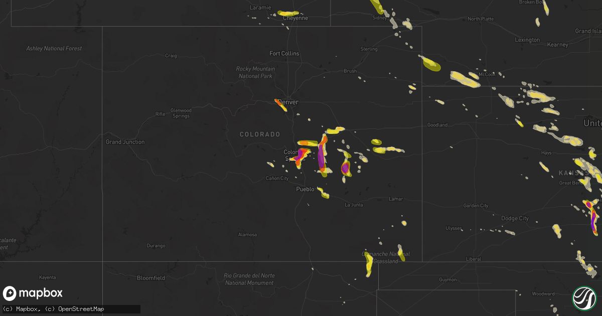
Hail Map on July 28, 2016
Get this storm
July 28 map
$229
one time, instant access
Download today. No call, no setup
Keep the $229
Bought the map and want the full workflow? Apply the entire $229 to a subscription within 7 days. None of it is wasted.
Every map, not just this one
This buys you this map. Subscription and you get every map we run, in the markets you choose from a few cities to whole states to nationwide. Plus real-time alerts the moment a storm fires.
Contact data
Name, contact info, occupancy, even credit band for addresses in the footprint. You go from where it hit to who to call.
Become the source they trust
Unlimited branding weather history reports on demand. You already have the documented answer ready for the property owner, and you are the one who showed up with it.
Property data and RoofTrace estimates
Pull up any address you have got, its value and the exact code rules for that jurisdiction, straight from One Click Code. Then RoofTrace estimates the squares, pitch, and roof value, priced the way you price.
States Impacted by Hail Map on July 28, 2016
Storm reports
Nevada
| Date | Description |
|---|---|
| 07/28/20165:10 PM CDT | An automated weather sensor in alamo reported a wind gust from a thunderstorm of 76 mph. There was also a report of a small tree down near the intersection of highway 9 |
Missouri
| Date | Description |
|---|---|
| 07/28/20163:59 PM CDT | Sheriffs department reporting both lanes of state route 51...6 miles north of broseley...blocked by trees blown down |
Utah
| Date | Description |
|---|---|
| 07/28/20165:45 PM CDT | Dry microburst |
| 07/28/20164:03 PM CDT | Dry microburst at enterprise raws |
| 07/28/20162:57 PM CDT | Dry microburst at telegraph flat raws |
Colorado
| Date | Description |
|---|---|
| 07/28/201612:37 AM CDT | . |
| 07/28/201612:17 AM CDT | Lasted until 1117 pm. |
| 07/27/201611:58 PM CDT | . |
| 07/27/201611:54 PM CDT | . |
| 07/27/201611:51 PM CDT | . |
| 07/27/201611:35 PM CDT | . |
| 07/27/201611:35 PM CDT | . |
| 07/27/201611:35 PM CDT | . |
| 07/27/201611:28 PM CDT | . |
| 07/27/201611:23 PM CDT | . |
| 07/27/201611:23 PM CDT | . |
| 07/27/201611:15 PM CDT | . |
| 07/27/201611:15 PM CDT | . |
| 07/27/201611:15 PM CDT | . |
| 07/27/201611:11 PM CDT | . |
| 07/27/201611:06 PM CDT | . |
| 07/27/201611:05 PM CDT | . |
| 07/27/201611:04 PM CDT | . |
| 07/27/201611:03 PM CDT | 2.25 inch hail reported by kcos. . |
| 07/27/201611:00 PM CDT | . |
| 07/27/201611:00 PM CDT | . |
| 07/27/201610:59 PM CDT | . |
| 07/27/201610:57 PM CDT | . |
| 07/27/201610:53 PM CDT | . |
| 07/27/201610:52 PM CDT | . |
| 07/27/201610:41 PM CDT | A local report indicates 1.25 inch wind near LITTLETON |
| 07/27/201610:40 PM CDT | A local report indicates 1.50 inch wind near 2 W LITTLETON |
| 07/27/201610:34 PM CDT | . |
| 07/27/201610:30 PM CDT | A local report indicates 1.50 inch wind near 1 S LAKEWOOD |
| 07/27/201610:25 PM CDT | A local report indicates 1.25 inch wind near LAKEWOOD |
| 07/27/201610:22 PM CDT | . |
| 07/27/201610:07 PM CDT | A local report indicates 1.00 inch wind near GOLDEN |
| 07/27/201610:07 PM CDT | A local report indicates 1.25 inch wind near LAKEWOOD |
| 07/27/201610:07 PM CDT | A local report indicates 1.50 inch wind near 2 S GOLDEN |
| 07/27/20169:27 PM CDT | Asos station la junta airport /lhx/. |
| 07/27/20168:41 PM CDT | A local report indicates 1.00 inch wind near 21 N ORDWAY |
| 07/27/20168:15 PM CDT | . |
| 07/27/20167:44 PM CDT | . |
| 07/27/20167:43 PM CDT | Quarter to golf ball size hail. . |
| 07/27/20167:43 PM CDT | . |
| 07/27/20167:34 PM CDT | . |
| 07/27/20167:25 PM CDT | . |
| 07/27/20167:24 PM CDT | . |
| 07/27/20167:21 PM CDT | . |
| 07/27/20167:15 PM CDT | . |
| 07/27/20167:10 PM CDT | . |
| 07/27/20167:05 PM CDT | . |
Illinois
| Date | Description |
|---|---|
| 07/28/20163:55 PM CDT | Intense heavy rain. Thunder and lightning. Extensive lowland and street flooding. |
| 07/27/20168:05 PM CDT | Estimated 50 - 60 mph winds. Evansville se side. |
Kansas
| Date | Description |
|---|---|
| 07/28/20166:53 PM CDT | Estimated 60mph winds...corrected for time. |
| 07/28/20166:50 PM CDT | Delayed report. |
| 07/28/20166:40 PM CDT | Estimated 60mph winds. |
| 07/28/20166:40 PM CDT | Estimated 60mph winds |
| 07/28/20166:23 PM CDT | Reported at ellsworth airport...corrected for time. |
| 07/28/20166:22 PM CDT | 18 inch diameter tree snapped and numerous 3-5 inch diameter limbs are down. |
| 07/28/20166:22 PM CDT | A local report indicates 73 MPH wind near CONCORDIA AIRPORT |
| 07/28/20166:12 PM CDT | Estimated 70-80 mph wind gusts. Tree damage unknown. |
| 07/28/20166:09 PM CDT | Sustained 55 mph with gusts to 70 mph... Possibly higher. |
| 07/28/20165:54 PM CDT | A local report indicates 62 MPH wind near SMITH CENTER AIRPORT |
| 07/28/20165:47 PM CDT | This is a new peak gust associated with the back-side of the storm. Update to original report includes law enforcement reporting trees down in town. |
| 07/28/20165:45 PM CDT | 6 inch diameter healthy tree branch down in beloit. Report and photo via social media. |
| 07/28/20165:43 PM CDT | Personal mesonet station. Exact time estimated from radar as it occurred between 5-minute obs |
| 07/28/20165:40 PM CDT | Reported at ellsworth airport |
| 07/28/20165:40 PM CDT | Estimated 60mph winds with some tree limbs down. |
| 07/28/20165:11 PM CDT | A local report indicates 60 MPH wind near 2 SW ALTON |
| 07/28/20165:10 PM CDT | A local report indicates 71 MPH wind near SMITH CENTER AIRPORT |
| 07/28/20164:55 PM CDT | Reports of tree branches and possibly trees down in athol. Time estimated from radar. |
| 07/28/20164:55 PM CDT | A local report indicates 60 MPH wind near 1 N KENSINGTON |
| 07/28/20164:40 PM CDT | County storm spotters report several trees up to 12 inches in diameter were snapped with the storm and 1 business lost part of its roof with the storm. Pea size hail wa |
| 07/28/20164:40 PM CDT | A local report indicates 60 MPH wind near 6 E PHILLIPSBURG |
| 07/28/20164:34 PM CDT | Pea size hail |
| 07/28/20164:30 PM CDT | Time estimated from radar. |
| 07/28/20164:26 PM CDT | Sarrada farms mesonet in logan. |
| 07/28/20164:20 PM CDT | Time estimated from radar |
| 07/28/20164:15 PM CDT | Estimated 60 mph or higher wind gusts. A grain bin in construction was blown over. |
| 07/28/20164:06 PM CDT | A local report indicates 58 MPH wind near NORTON |
| 07/28/20164:00 PM CDT | Power lines reported down in town. |
| 07/28/20163:56 PM CDT | Tree damage reported on the north side of town. |
| 07/28/20163:55 PM CDT | There were multiple reports of limbs and trees downed. This is a correction of the report issued at 355 pm cdt. |
| 07/28/20163:41 PM CDT | A local report indicates 61 MPH wind near STROTHER FIELD AIRPORT |
| 07/28/20163:41 PM CDT | Hail was nickel to quarter size. |
| 07/28/20163:28 PM CDT | A local report indicates 62 MPH wind near OBERLIN |
| 07/28/201610:00 AM CDT | Observer reported that a tree fell onto a roof of a home in erie. |
| 07/27/20169:15 PM CDT | Large tree downed in town. |
| 07/27/20169:08 PM CDT | A local report indicates 65 MPH wind near 2 NNW EL DORADO |
| 07/27/20168:56 PM CDT | 1 to 2 inch diameter limbs down. Estimates 50 mph wind gust. |
| 07/27/20168:43 PM CDT | A local report indicates 78 MPH wind near 2 N EAST WICHITA |
| 07/27/20168:41 PM CDT | Power pole snapped. |
| 07/27/20168:34 PM CDT | 50 to 60 mph winds. |
| 07/27/20168:32 PM CDT | Half a bradford pear tree broken off. |
| 07/27/20168:30 PM CDT | A local report indicates 70 MPH wind near 1 NE NORWICH |
| 07/27/20168:28 PM CDT | Near 119th and 21st. |
| 07/27/20168:28 PM CDT | A local report indicates 65 MPH wind near ANDALE |
| 07/27/20168:28 PM CDT | Large tree limbs down near 21st and tyler. Report via twitter. |
| 07/27/20168:24 PM CDT | 75-85 mph winds were reported on nw 21st street between tyler and maize roads. |
| 07/27/20168:23 PM CDT | A local report indicates 61 MPH wind near WICHITA EISENHOWER NATL |
| 07/27/20168:20 PM CDT | A local report indicates 65 MPH wind near MAIZE |
| 07/27/20168:20 PM CDT | Large tree blown down. Via twitter. |
| 07/27/20168:19 PM CDT | A local report indicates 65 MPH wind near MOUNT HOPE |
| 07/27/20168:15 PM CDT | Several large branches down across town. Trees twisted and split. Estimated 85 mph winds. Delayed report. |
| 07/27/20168:10 PM CDT | Several large limbs down across town. |
| 07/27/20168:05 PM CDT | Multiple 12 inch three limbs down. |
| 07/27/20168:05 PM CDT | A local report indicates 78 MPH wind near MOUNT HOPE |
| 07/27/20168:04 PM CDT | 65 to 70 mph. |
| 07/27/20167:55 PM CDT | Ping pong to tennis ball hail. |
| 07/27/20167:55 PM CDT | Delayed report of a 4-5 inch diameter tree limb snapped. Picture and report via twitter. |
| 07/27/20167:42 PM CDT | Estimated 60mph winds. |
| 07/27/20167:35 PM CDT | A local report indicates 60 MPH wind near HUTCHINSON |
| 07/27/20167:30 PM CDT | A local report indicates 60 MPH wind near NNW JUNCTION CITY |
| 07/27/20167:27 PM CDT | 50-60 mph wind gusts |
| 07/27/20167:26 PM CDT | A local report indicates 60 MPH wind near MCPHERSON |
| 07/27/20167:25 PM CDT | 60 to 70 mph. Pea size hail also reported. |
| 07/27/20167:24 PM CDT | 2 foot diameter tree blown over. Golf cart picked up and blown into a field. |
| 07/27/20167:19 PM CDT | Estimated 60mph wind gust. |
| 07/27/20167:14 PM CDT | A local report indicates 2.00 inch wind near SYLVIA |
| 07/27/20167:12 PM CDT | A local report indicates 1.75 inch wind near SYLVIA |
Delaware
| Date | Description |
|---|---|
| 07/28/20164:26 PM CDT | A local report indicates 63 MPH wind near DOVER AIR FORCE BASE |
Texas
| Date | Description |
|---|---|
| 07/28/20166:06 PM CDT | A local report indicates 60 MPH wind near 11 SW SWEETWATER |
| 07/28/20165:22 PM CDT | Spotter reports 60 mph wind gust as well as 3 inch diameter tree limbs down. |
| 07/28/20165:15 PM CDT | 60 mph wind gust reported in saginaw. |
| 07/28/20165:15 PM CDT | Fence and 6 to 8 inch diameter trees down in saginaw. |
| 07/28/20164:25 PM CDT | Numerous trees down. |
Nebraska
| Date | Description |
|---|---|
| 07/28/20163:06 PM CDT | A local report indicates 59 MPH wind near MCCOOK |
| 07/28/20161:46 PM CDT | Hail covered the road and the largest was quarter size. |
| 07/28/201610:53 AM CDT | A local report indicates 1.00 inch wind near 5 SE BAYARD |
| 07/28/201610:50 AM CDT | Reported via facebook post. |
| 07/28/201610:43 AM CDT | A local report indicates 1.50 inch wind near 3 E MCGREW |
| 07/28/201610:41 AM CDT | A local report indicates 1.25 inch wind near 2 E MCGREW |
| 07/28/201610:07 AM CDT | A local report indicates 1.25 inch wind near 8 N SCOTTSBLUFF |
| 07/27/201611:02 PM CDT | In addition to the strong winds...very heavy rain...with over 1 inch falling in a short amount of time. |
| 07/27/20169:31 PM CDT | Pea to ping pong ball size hail. |
Indiana
| Date | Description |
|---|---|
| 07/28/20166:45 PM CDT | Tree snapped...approximately 1 foot in diameter. Time approximated from radar. |
| 07/27/20168:05 PM CDT | Estimated 50 - 60 mph winds. Evansville se side. |
Maine
| Date | Description |
|---|---|
| 07/28/20164:45 PM CDT | Large tree down. Time estimated from radar. |
| 07/28/20163:15 PM CDT | Tree on wires and telephone poles down on west river road. Time estimated from radar. Delayed report. |
| 07/28/20163:15 PM CDT | Large tree down. Time estimated from radar. Delayed report. |
| 07/28/20163:00 PM CDT | Tree down near dennis court |
| 07/28/20162:55 PM CDT | 2 trees down on west road |
| 07/28/20162:49 PM CDT | Tree down on power lines oakland road. |
| 07/28/20162:45 PM CDT | Tree down in middle of dunn road. |
| 07/28/20162:23 PM CDT | A local report indicates 1.50 inch wind near EASTON |
| 07/28/20162:20 PM CDT | A local report indicates 1.00 inch wind near PRESQUE ISLE |
| 07/28/20162:15 PM CDT | One tree reported down in the center of danforth. |
| 07/28/20162:10 PM CDT | Trees down at umpi. Time estimated from the radar. |
| 07/28/20162:02 PM CDT | 5 trees down along route 163 near haystack mountain blocking the road. |
| 07/28/20161:50 PM CDT | Trees down on curtis farm road. Time estimated from the radar. |
| 07/28/20161:40 PM CDT | Multiple trees down along route 168. |
| 07/28/20161:40 PM CDT | Several trees down in town. Time estimated from the radar. |
| 07/28/20161:40 PM CDT | Trees down on curtis farm road. |
| 07/28/20161:25 PM CDT | 4 trees down along mile marker 238 on interstate 95. |
| 07/28/20161:20 PM CDT | Numerous trees down and snapped with downed power lines on merrill pond in lee. Report forwarded by utility company. |
| 07/28/20161:20 PM CDT | A local report indicates 1.50 inch wind near LEE |
| 07/28/20161:20 PM CDT | A number of trees down along route 6. |
| 07/28/201612:55 PM CDT | Two trees down on washburn/taber road. |
Virginia
| Date | Description |
|---|---|
| 07/28/20166:40 PM CDT | Tree down on power line. |
| 07/28/20165:42 PM CDT | Tree blown down near 270 riverville road. |
| 07/28/20165:40 PM CDT | Several trees blown down near 2018 riverville road |
| 07/28/20165:26 PM CDT | One tree down near the intersection of park avenue and fort avenue |
| 07/28/20165:25 PM CDT | Tree fell across powerline and partially blocked 3245 forrest brook road. |
| 07/28/20165:11 PM CDT | Tree blown down into garage. Via social media. |
| 07/28/20164:50 PM CDT | One large tree branch down along walker street in lexington |
| 07/28/20164:50 PM CDT | One tree down on overhill drive |
| 07/28/20164:30 PM CDT | One tree down on turnpike road |
| 07/28/20164:25 PM CDT | Thunderstorm winds brought down trees which partially blocked portions of old rail road between hipes and oriskany. |
| 07/28/20162:13 PM CDT | Tree down across roadway near the intersection of lions lane and howellsville road. |
| 07/28/20162:10 PM CDT | Tree down across the roadway in the 2300 block of bishop meade road. |
| 07/28/20161:32 PM CDT | Tree down on power lines in the 600 block of oates road. |
| 07/28/201612:59 PM CDT | Tree down in the 300 block of mount olive road. |
| 07/27/201611:35 PM CDT | Several trees downed on transformers between 1235am and 1255am. |
| 07/27/201611:05 PM CDT | 1 tree down on howardsville road. |
| 07/27/201610:35 PM CDT | Thunderstorm winds downed a tree along route 635 near the town of appomattox. |
| 07/27/201610:10 PM CDT | Thunderstorm winds knocked down a tree across dearborn road. |
| 07/27/201610:06 PM CDT | One tree down on route 501 north near the graves mill exit |
| 07/27/201610:01 PM CDT | One tree down near 3100 lizard ridge road |
| 07/27/20169:45 PM CDT | One tree down on route 460 next to johnson school road |
| 07/27/20169:35 PM CDT | One tree down at the intersection of feldspar road and morgans church road |
| 07/27/20169:31 PM CDT | One tree down on white house road near moneta |
| 07/27/20169:05 PM CDT | Trees down across mount landing road. |
| 07/27/20168:50 PM CDT | Tree down along smithfield road. |
| 07/27/20167:52 PM CDT | Tree down along route 100. |
| 07/27/20167:37 PM CDT | Tree down at intersection of coonskin hollow road and wolf creek road. |
| 07/27/20167:35 PM CDT | Numerous trees and power lines down around the parksley area. . |
| 07/27/20167:10 PM CDT | Tree down at the intersection of jessie dupont memorial hwy and old glebe point rd with vehicle accident. |
Wyoming
| Date | Description |
|---|---|
| 07/28/20166:15 PM CDT | A local report indicates 1.25 inch wind near 5 NNW CHEYENNE |
| 07/28/20166:15 PM CDT | Hail was slightly larger than quarters but less than half dollar size. Reported on horse creek road. |
| 07/28/20166:00 PM CDT | A local report indicates 1.50 inch wind near 5 SSE FEDERAL |
Maryland
| Date | Description |
|---|---|
| 07/28/20166:59 PM CDT | A local report indicates 66 MPH wind near 8 E SMITH ISLAND |
| 07/28/20166:55 PM CDT | A local report indicates 62 MPH wind near 8 E SMITH ISLAND |
| 07/28/20166:53 PM CDT | Phone and power lines down. |
| 07/28/20163:40 PM CDT | A local report indicates 66 MPH wind near TOLCHESTER |
| 07/28/20161:10 PM CDT | Tree downed across route 90. Time approximated by radar. |
New York
| Date | Description |
|---|---|
| 07/28/20165:30 PM CDT | Trees and wires down |
| 07/28/20161:25 PM CDT | 1 tree down at intersection of rte 8 and 28 |
Pennsylvania
| Date | Description |
|---|---|
| 07/28/20161:50 PM CDT | Numerous trees down along bear road in manchester twp. |
| 07/28/201612:05 PM CDT | Tree and wires down on car on stargazers rd |
| 07/28/201612:05 PM CDT | Report of trees and power lines down in the township |
Arizona
| Date | Description |
|---|---|
| 07/28/20166:16 PM CDT | Pictures from trained spotter via social media showing 1.5 inch hail. |
Oklahoma
| Date | Description |
|---|---|
| 07/28/20166:50 PM CDT | A local report indicates 60 MPH wind near 7 W HINTON |
| 07/28/20165:50 PM CDT | Power lines down at woodland hills mall. |
| 07/28/20165:26 PM CDT | 29th and peoria |
| 07/28/20164:25 PM CDT | A local report indicates 58 MPH wind near 4 SSE MARSHALL |
| 07/28/20164:05 PM CDT | A local report indicates 60 MPH wind near 1 SE CHILOCCO |
| 07/28/20164:01 PM CDT | Near zero visibility in blowing dust. |
| 07/28/20163:40 PM CDT | A local report indicates 58 MPH wind near 3 SE BRECKENRIDGE |
| 07/28/20166:40 AM CDT | 15 inch diameter oak tree heavily damaged. |
| 07/28/20166:23 AM CDT | A local report indicates 60 MPH wind near EDMOND |
| 07/28/20164:50 AM CDT | A local report indicates 60 MPH wind near 3 SE BRECKENRIDGE |
Cities Impacted by Hail Map on July 28, 2016
- Watonga, OK
- Claflin, KS
- Wilson, KS
- Bunker Hill, KS
- Dorrance, KS
- Hoisington, KS
- Bayard, NE
- Minatare, NE
- Medicine Lodge, KS
- Lake City, KS
- Judsonia, AR
- Birch Tree, MO
- Luray, KS
- Lucas, KS
- Winfield, KS
- Ramah, CO
- Beloit, KS
- Raymond, KS
- Alden, KS
- Kirkland, AZ
- Peyton, CO
- Newkirk, OK
- Ellinwood, KS
- Chase, KS
- Bushton, KS
- Nowata, OK
- Delaware, OK
- Fowler, KS
- Minneola, KS
- Eskridge, KS
- Heathsville, VA
- Lancaster, VA
- Mutual, OK
- Vici, OK
- Reedville, VA
- Winn, ME
- Lee, ME
- Burlington, ME
- Lincoln, ME
- Springfield, ME
- Pawhuska, OK
- Paradise, KS
- Waldo, KS
- Colorado Springs, CO
- Matheson, CO
- Limon, CO
- Agate, CO
- Flagler, CO
- Dunnsville, VA
- Boone, CO
- Fowler, CO
- Lusk, WY
- Franklin Grove, IL
- La Cygne, KS
- Mattawamkeag, ME
- Wytopitlock, ME
- Kingman, ME
- Millinocket, ME
- Brownville, ME
- Senath, MO
- West Enfield, ME
- Calhan, CO
- Culbertson, NE
- Williamsburg, KS
- White Marsh, MD
- Middle River, MD
- Wagon Mound, NM
- Stratton, NE
- Benkelman, NE
- Max, NE
- Ellsworth, KS
- Sylvan Grove, KS
- Coatesville, PA
- Mitchell, NE
- Scottsbluff, NE
- Harrison, NE
- Bloomington, IL
- Downs, IL
- Cheyenne, WY
- Polo, IL
- Arlington, IL
- Easton, ME
- Mapleton, ME
- Presque Isle, ME
- Sylvia, KS
- Cherokee, OK
- Little River, KS
- Inman, KS
- Lyons, KS
- Windom, KS
- Simla, CO
- Kit Carson, CO
- Chestertown, MD
- Lake Geneva, WI
- Burlington, WI
- Elkhorn, WI
- Springfield, WI
- Delavan, WI
- Adair, OK
- Big Cabin, OK
- West Chester, PA
- Kennett Square, PA
- Tappahannock, VA
- Le Roy, IL
- Cunningham, KS
- Burlington, OK
- Alva, OK
- Trenton, NE
- Ponca City, OK
- Julesburg, CO
- Ovid, CO
- Chappell, NE
- Fountain, CO
- Saint Inigoes, MD
- Ridge, MD
- Scotland, MD
- Dameron, MD
- Ingalls, KS
- Geneva, IL
- Buhler, KS
- Burrton, KS
- Hutchinson, KS
- Madison Heights, VA
- Elbert, CO
- Woodston, KS
- Albany, TX
- Turon, KS
- Lorraine, KS
- Geneseo, KS
- Erie, KS
- Wray, CO
- Ordway, CO
- Rush, CO
- Couch, MO
- Myrtle, MO
- Yoder, CO
- Shawnee, WY
- Maywood, NE
- Sedgwick, CO
- Abilene, TX
- Cowden, IL
- Stillwater, OK
- Spivey, KS
- Kingman, KS
- Arlington, KS
- Dalton, NE
- Mcgrew, NE
- Bridgeport, NE
- Harrisburg, NE
- Alliance, NE
- Lusby, MD
- Ansley, NE
- Mason City, NE
- Westerville, NE
- Tulsa, OK
- Vernon, CO
- Littleton, CO
- Denver, CO
- Golden, CO
- McCracken, KS
- La Crosse, KS
- Virginia Beach, VA
- Mulvane, KS
- Udall, KS
- Belle Plaine, KS
- Stockton, KS
- Kirwin, KS
- Phillipsburg, KS
- Glade, KS
- Logan, KS
- Young, AZ
- Cedar Vale, KS
- Grenola, KS
- Dover, DE
- Magnolia, DE
- Dover Afb, DE
- Camden Wyoming, DE
- Cheswold, DE
- Hartly, DE
- Plainville, KS
- Stafford, KS
- Bridgeville, DE
- Ellendale, DE
- Georgetown, DE
- Seaford, DE
- Greenwood, DE
- Concord, VA
- Appomattox, VA
- Spout Spring, VA
- Berlin, MD
- Goode, VA
- Utopia, TX
- Muskogee, OK
- Holyoke, CO
- Palco, KS
- Damar, KS
- Fredericksburg, VA
- Spotsylvania, VA
- Natoma, KS
- Prairie View, KS
- Lenora, KS
- Agra, KS
- Almena, KS
- Long Island, KS
- Marshall, OK
- Braman, OK
- Medford, OK
- Dixon, IL
- Oregon, IL
- Woosung, IL
- Comstock, NE
- Broken Bow, NE
- Taylor, NE
- Sargent, NE
- Indianola, NE
- Abbyville, KS
- La Vernia, TX
- Oberlin, KS
- Milan, KS
- Argonia, KS
- Callao, VA
- Lottsburg, VA
- Dover, PA
- York, PA
- Champion, NE
- Glasco, KS
- Kim, CO
- Grenville, NM
- Plevna, KS
- Brookland, AR
- Lake City, AR
- Calumet, OK
- Geary, OK
- Campo, CO
- Winona, KS
- Poseyville, IN
- Cynthiana, IN
- Amorita, OK
- Paragould, AR
- Marmaduke, AR
- Okarche, OK
- Oconto, NE
- Sumner, NE
- Norton, KS
- Hunter, OK
- Yarnell, AZ
- Prescott, AZ
- Clinton, IL
- Karval, CO
- Cambridge, MD
- East New Market, MD
- Linkwood, MD
- Secretary, MD
- Trappe, MD
- Hurlock, MD
- Douglas, OK
- Decatur, MI
- Grand Junction, MI
- Pullman, MI
- Genoa City, WI
- Lombard, IL
- Newtown, VA
- Saint Stephens Church, VA
- Geuda Springs, KS
- Sand Springs, OK
- Hugo, CO
- Wellington, KS
- East Chicago, IN
- Chicago, IL
- Hammond, IN
- Haviland, KS
- Sidney, NE
- Peck, KS
- Lothian, MD
- Tracys Landing, MD
- Deale, MD
- Churchton, MD
- West River, MD
- Harwood, MD
- Manville, WY
- Lost Springs, WY
- Kiowa, KS
- Golden Gate, IL
- Pryor, OK
- Hill City, KS
- Penokee, KS
- Beaver City, NE
- Holyrood, KS
- Pritchett, CO
- Garnett, KS
- Greeley, KS
- Richmond, KS
- Tangier, VA
- Poplar Bluff, MO
- Canon City, CO
- Arkansas City, KS
- Jonesboro, AR
- Conway Springs, KS
- Elizabeth, CO
- Caret, VA
- Louisburg, KS
- Paola, KS
- Ellery, IL
- Oxford, KS
- Elburn, IL
- Maple Park, IL
- Russell, KS
- Montpelier, VA
- Bumpass, VA
- Saint Charles, IL
- Elgin, IL
- Arbyrd, MO
- Cardwell, MO
- Rector, AR
- Stockdale, TX
- Van Buren, MO
- Doniphan, MO
- Nickerson, KS
- Burlingame, KS
- Metamora, IL
- Jennings, KS
- Clayton, KS
- Norcatur, KS
- Fort Worth, TX
- Parker, CO
- Manhattan, IL
- Herndon, KS
- Atwood, KS
- Laredo, TX
- Mulkeytown, IL
- Christopher, IL
- Seguin, TX
- Winslow, IL
- Pueblo, CO
- Throckmorton, TX
- Parsonsburg, MD
- Zenda, KS
- Greenfield, OK
- Downingtown, PA
- Essex, MD
- Perry, OK
- Cameron, OK
- Crystal City, TX
- Orangeville, IL
- Caulfield, MO
- Dora, MO
- Champlain, VA
- Springfield, IL
- Owensville, IN
- Farnham, VA
- Lafe, AR
- Caldwell, KS
- Gurley, NE
- Bald Knob, AR
- Powhatan, VA
- Midlothian, VA
- Colby, KS
- Caribou, ME
- Carlock, IL
- Montezuma, KS
- Fisk, MO
- Lincoln, IL
- Benson, IL
- Roanoke, IL
- Morland, KS
- Devine, TX
- Kennett, MO
- Greenville, ME
- Minonk, IL
- Bickmore, WV
- Clay, WV
- Ewell, MD
- Bird City, KS
- Puxico, MO
- Lexington Park, MD
- El Paso, IL
- Lowpoint, IL
- Accomac, VA
- Fairmont, OK
- Lance Creek, WY
- Sublette, IL
- Mendota, IL
- Parks, NE
- Taloga, OK
- Guffey, CO
- St John, KS
- Roggen, CO
- Avondale, CO
- Spiro, OK
- Pocola, OK
- Lodgepole, NE
- Lebanon, NE
- Bazine, KS
- Cheyenne Wells, CO
- Bluff City, KS
- Enid, OK
- Covington, OK
- Lena, IL
- Warren, IL
- Mchenry, IL
- Shattuck, OK
- Bim, WV
- Clothier, WV
- Yolyn, WV
- Amherstdale, WV
- Beech Grove, AR
- Partridge, KS
- New Castle, VA
- Sterling, KS
- Mount Carmel, IL
- Browns, IL
- Delmar, MD
- Raton, NM
- Sedan, KS
- Kensington, KS
- Squires, MO
- Wasola, MO
- Frederica, DE
- Smyrna, DE
- Granada, CO
- Wappapello, MO
- Lincoln, KS
- Penrose, CO
- Gilberts, IL
- Huntley, IL
- Douglas, WY
- Kaw City, OK
- Shidler, OK
- Darien, WI
- Russell, AR
- Britton, MI
- Hinton, OK
- Knotts Island, NC
- Canton, OK
- Buford, WY
- Douglass, KS
- Chanute, KS
- Haysville, KS
- Derby, KS
- Kensett, AR
- Searcy, AR
- Hydro, OK
- Laramie, WY
- Fort Mcdowell, AZ
- Miami, AZ
- Laurel, DE
- Bethel, DE
- McCook, NE
- Burden, KS
- Fairview, OK
- Isabella, OK
- Beebe, AR
- Crook, CO
- South Wayne, WI
- Yuma, CO
- Fe Warren Afb, WY
- Salisbury, MD
- Pittsville, MD
- Anselmo, NE
- McGee, MO
- Edgewater, MD
- Pasadena, MD
- Severna Park, MD
- Hampshire, IL
- Saint Francis, KS
- Washburn, ME
- Deridder, LA
- Sapulpa, OK
- Akron, CO
- Davidsonville, MD
- Forest, VA
- Harveyville, KS
- Thayer, KS
- Altoona, KS
- Exmore, VA
- Ridgely, TN
- Oxford, AR
- Brockwell, AR
- Alton, MO
- Hebron, IL
- Hardtner, KS
- Aylett, VA
- Orleans, NE
- Bedford, VA
- Kingman, AZ
- Warsaw, VA
- Houston, TX
- Sanford, VA
- Temperanceville, VA
- Jemez Springs, NM
- Esbon, KS
- Downs, KS
- Mayfield, KS
- Quinton, VA
- Rush Center, KS
- Jamaica, VA
- Lyndon, KS
- Vassar, KS
- Sugar City, CO
- Englewood, CO
- Brewster, NE
- Imperial, NE
- Haigler, NE