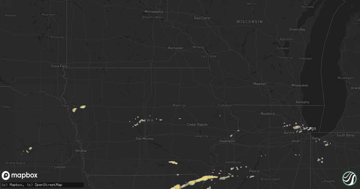
Hail Map in Illinois on July 28, 2011
Get this storm
July 28 map
$229
one time, instant access
Download today. No call, no setup
Keep the $229
Bought the map and want the full workflow? Apply the entire $229 to a subscription within 7 days. None of it is wasted.
Every map, not just this one
This buys you this map. Subscription and you get every map we run, in the markets you choose from a few cities to whole states to nationwide. Plus real-time alerts the moment a storm fires.
Contact data
Name, contact info, occupancy, even credit band for addresses in the footprint. You go from where it hit to who to call.
Become the source they trust
Unlimited branding weather history reports on demand. You already have the documented answer ready for the property owner, and you are the one who showed up with it.
Property data and RoofTrace estimates
Pull up any address you have got, its value and the exact code rules for that jurisdiction, straight from One Click Code. Then RoofTrace estimates the squares, pitch, and roof value, priced the way you price.
Storm reports in Illinois
Illinois
| Date | Description |
|---|---|
| 07/28/201111:50 AM CDT | Part of the roof of a muffler shop was damaged. Power lines down. |
| 07/28/20116:30 AM CDT | Trees were blown down across route 8 in elmwood. |
| 07/28/20116:20 AM CDT | Numerous corn fields flattened by strong thunderstorm winds around yates city. |
| 07/28/20116:16 AM CDT | Numerous large tree limbs down. Swop |
| 07/28/20112:15 AM CDT | Delayed report. Extensive tree limb damage throughout the village. A large sign in front of a restaurant was pulled from its concrete base. A telephone pole was also bl |
| 07/28/20111:42 AM CDT | Many trees downed in glen ellyn including a tree that damaged a house and resulted in closure of park blvd. Numerous large tree limbs and at least one uprooted tree alo |
| 07/27/201111:50 PM CDT | Debris and signs down near north avenue and summit. |
All States Impacted by Hail Map on July 28, 2011
Cities Impacted by Hail Map on July 28, 2011
- Deering, ND
- Glenburn, ND
- Wakefield, KS
- Clay Center, KS
- Lodgepole, SD
- Dupree, SD
- Eagle Butte, SD
- Ekalaka, MT
- Bethune, CO
- Salix, IA
- Moville, IA
- Bronson, IA
- Hornick, IA
- Hoyt, KS
- Denison, KS
- Philadelphia, MO
- Emden, MO
- Shelbina, MO
- Shelbyville, MO
- Ness City, KS
- Buffalo, SD
- Reva, SD
- Bushnell, IL
- Burlington, CO
- Trenton, NE
- Culbertson, NE
- Belle Fourche, SD
- Valley Falls, KS
- Holton, KS
- Yuma, CO
- Prairie City, SD
- Meadow, SD
- Bison, SD
- Arriba, CO
- Lindon, CO
- Anton, CO
- Cope, CO
- Goodland, KS
- Pritchett, CO
- Flagler, CO
- Kit Carson, CO
- Ames, IA
- Benkelman, NE
- Joes, CO
- Burlington, ND
- Minot, ND
- Lombard, IL
- Alzada, MT
- Logan, KS
- Fort Myers, FL
- Ursa, IL
- Jetmore, KS
- Dover, MO
- Higginsville, MO
- Pekin, IL
- Akron, CO
- Pittsburgh, PA
- Verona, PA
- Karval, CO
- Laingsburg, MI
- Paw Paw, MI
- Weskan, KS
- La Monte, MO
- Knob Noster, MO
- Des Lacs, ND
- Berthold, ND
- Oskaloosa, KS
- Wallace, NE
- Greenwood, MO
- Pleasant Hill, MO
- Bosworth, MO
- Lexington, MO
- Winigan, MO
- New Boston, MO
- Linneus, MO
- Purdin, MO
- Monticello, MO
- Lewistown, MO
- Capitol, MT
- Paola, KS
- Spearfish, SD
- Keystone, SD
- Hill City, SD
- Rapid City, SD
- Clyde, KS
- Reeder, ND
- Edina, MO
- Baring, MO
- Kirksville, MO
- Fort Pierre, SD
- Marshall, MO
- Green Castle, MO
- Brookfield, MO
- Green City, MO
- Meadville, MO
- Wheeling, MO
- Milan, MO
- Browning, MO
- Enders, NE
- Wauneta, NE
- Hettinger, ND
- Raton, NM
- Wiley, CO
- Lamar, CO
- Bennington, KS
- Minneapolis, KS
- Miltonvale, KS
- Upton, WY
- Moorcroft, WY
- Scranton, ND
- Bowman, ND
- Terry, MT
- Riley, KS
- Randolph, KS
- Green, KS
- Leonardville, KS
- Blakesburg, IA
- Ottumwa, IA
- Whiting, KS
- Wild Horse, CO
- Manter, KS
- Vona, CO
- Hayes Center, NE
- Chestertown, MD
- Rock Hall, MD
- Branson, CO
- Bird City, KS
- Berwick, IL
- Abingdon, IL
- Saint Augustine, IL
- Burdett, KS
- Dallas City, IL
- Gorin, MO
- Novinger, MO
- Hurdland, MO
- Greentop, MO
- Hamilton, IL
- Brashear, MO
- Rutledge, MO
- Memphis, MO
- Wyaconda, MO
- Luray, MO
- Montrose, IA
- Keokuk, IA
- Blandinsville, IL
- Wayland, MO
- Nauvoo, IL
- Arbela, MO
- Carthage, IL
- Kahoka, MO
- La Harpe, IL
- Saint Patrick, MO
- La Plata, MO
- Argyle, IA
- Niota, IL
- Lees Summit, MO
- Champion, NE
- Lantry, SD
- Colby, KS
- Oakley, KS
- Wanatah, IN
- Valparaiso, IN
- Boone, IA
- Holyoke, CO
- Palisade, NE
- Lemmon, SD
- Eads, CO
- Avon, IL
- Prairie City, IL
- Colorado Springs, CO
- Las Cruces, NM
- Saint Petersburg, FL
- Tribune, KS
- Saint Charles, IL
- Maple Park, IL
- Elburn, IL
- Fremont, OH
- Clyde, OH
- Utica, KS
- Ransom, KS
- Bunceton, MO
- Tipton, MO
- White Sands Missile Range, NM
- Warrendale, PA
- Cranberry Township, PA
- Wexford, PA
- Mars, PA
- Baden, PA
- Venice, FL
- Ralph, SD
- Cheyenne Wells, CO
- Devils Tower, WY
- Hulett, WY
- Sheridan Lake, CO
- Beaver, PA
- Beaver Falls, PA
- Anthon, IA
- Correctionville, IA
- Cawker City, KS
- Downs, KS
- Esbon, KS
- Corder, MO
- Monroe City, MO
- Hunnewell, MO
- La Grange, MO
- Nortonville, KS
- Allen, KS
- Kirk, CO
- Maquon, IL
- London Mills, IL
- Syracuse, KS
- Vernon, CO
- Walsenburg, CO
- Parks, NE
- Villa Park, IL
- West Chicago, IL
- Glendale Heights, IL
- Elmhurst, IL
- Wheaton, IL
- Addison, IL
- Carol Stream, IL
- Winfield, IL
- Glen Ellyn, IL
- Bensenville, IL
- Melrose Park, IL
- Osawatomie, KS
- Burlingame, KS
- Marietta, IL
- Sweet Springs, MO
- Odessa, MO
- Oak Grove, MO
- Bates City, MO
- Braymer, MO
- Gettysburg, SD
- Newell, SD
- Hamilton, MO
- Gallatin, MO
- Topeka, KS
- Mayetta, KS
- Spring Hill, KS
- Nemo, SD
- Deadwood, SD
- Lead, SD
- Hardin, MO
- Arapahoe, CO
- Edgerton, KS
- Imperial, NE
- Holt, MO
- Leoti, KS
- Central City, NE
- Humphreys, MO
- Bernard, IA
- Aurora, KS
- Saint Francis, KS
- Fallon, MT
- Richmond, MO
- Norborne, MO
- Wayne, IL
- Folsom, NM
- Mckeesport, PA
- Fair Oaks, IN
- Rensselaer, IN
- Sharon Springs, KS
- Kim, CO
- Mendon, IL
- Warsaw, IL
- Sutter, IL
- Jamestown, ND
- Buchanan, ND
- Placida, FL
- Rotonda West, FL
- Tornillo, TX
- Harrisonville, MO
- Peculiar, MO
- Chelsea, MI
- Clifton, KS
- Morganville, KS
- Magnolia, IL
- Selby, SD
- Concordia, KS
- Soldier, KS
- Silver Creek, NE
- Clarks, NE
- Ordway, CO
- Sugar City, CO
- Stratton, CO
- Wray, CO
- Coloma, MI
- Elkhart, KS
- Estero, FL
- Reading, KS
- Pingree, ND
- Plaza, ND
- Clinton, IA
- Fulton, IL
- Elk Grove Village, IL
- Schaumburg, IL
- Medinah, IL
- Roselle, IL
- Seneca, SD
- Bucyrus, KS
- Corning, KS
- Goff, KS
- Havensville, KS
- Royal, AR
- Monroeville, PA
- Turtle Creek, PA
- Carman, IL
- East Pittsburgh, PA
- Macomb, IL
- Colchester, IL
- Belton, MO
- Louisburg, KS
- Stilwell, KS
- Rush, CO
- Albia, IA
- Moravia, IA
- Bloomfield, IA
- Drakesville, IA
- Laredo, MO
- Trenton, MO
- Enon Valley, PA
- Darlington, PA
- Lawrence, MI
- Hartford, MI
- Horton, KS
- Muscotah, KS
- Eckley, CO
- Lebanon, SD
- Tolstoy, SD
- Lomax, IL
- Risingsun, OH
- New Springfield, OH
- New Galilee, PA
- East Palestine, OH
- Petersburg, OH
- Bessemer, PA
- Lisbon, OH
- Rogers, OH
- Naples, FL
- Armstrong, MO
- Westville, IN
- Lakin, KS
- Raritan, IL
- Smithshire, IL
- Manito, IL
- Moscow, KS
- Onaga, KS
- Vermillion, KS
- Chicago, IL
- Harwood Heights, IL
- Lyons, KS
- Stockton, KS
- Ewing, MO
- Canton, MO
- Loraine, IL
- Blue Springs, MO
- Grain Valley, MO
- Paradise, KS
- Mount Judea, AR
- Hugo, CO
- Courtenay, ND
- Nisland, SD
- Middleville, MI
- Grass Lake, MI
- Jackson, MI
- Darien, IL
- La Grange, IL
- Hinsdale, IL
- Willowbrook, IL
- Western Springs, IL
- Brookfield, IL
- Elgin, IL
- Hampshire, IL
- Woodridge, IL
- Downers Grove, IL
- Brunswick, MO
- Glasgow, MO
- Union Mills, IN
- Sewickley, PA
- New Brighton, PA
- Yates City, IL
- Glenshaw, PA
- Allison Park, PA
- Irwin, PA
- Duquesne, PA
- North Versailles, PA
- Greenock, PA
- Cheswick, PA
- Tarentum, PA
- Downing, MO
- Longford, KS
- Grand Junction, IA
- Ogden, IA
- Midland, PA
- East Liverpool, OH
- Negley, OH
- Higbee, MO
- Westmoreland, KS
- Olsburg, KS
- Fostoria, OH
- Tiffin, OH
- Winchester, KS
- McLouth, KS
- McClave, CO
- Watervliet, MI
- Gary, IN
- Hobart, IN
- Merrillville, IN
- Zelienople, PA
- Conway, PA
- Rochester, PA
- Freedom, PA
- Ambridge, PA
- Monaca, PA
- Bradfordwoods, PA
- Aliquippa, PA
- Evans City, PA
- Lone Jack, MO
- Cicero, IL
- Mount Ida, AR
- Larned, KS
- Salina, KS
- West Point, IL
- Cuba, IL
- Hill City, KS
- Frankfort, KS
- Kankakee, IL
- Portage, IN
- Hoven, SD
- Bonfield, IL
- Hastings, MI
- Mcpherson, KS
- Walsh, CO
- Effingham, KS
- Clemons, IA
- Kansas, OH
- New Middletown, OH
- Ludlow, MO
- Trinidad, CO
- Taylor, MO
- Maywood, MO
- La Belle, MO
- Bethel, MO
- Marshalltown, IA
- Albion, IA
- Jeannette, PA
- Penn, PA
- Harrison City, PA
- Trafford, PA
- Manor, PA
- Kidder, MO
- Jamesport, MO
- New Waterford, OH
- Mattawan, MI
- Capulin, NM
- Des Moines, NM
- Rushville, MO
- Wasco, IL
- Rocheport, MO
- Columbia, MO
- Whiteman Air Force Base, MO
- Camp Crook, SD
- Wampum, PA
- Ellwood City, PA
- Carrollton, MO
- Davenport, IA
- Princeton, IA
- Eldridge, IA
- Le Claire, IA
- Hoxie, KS
- Fombell, PA
- Quincy, IL
- Durham, MO
- McCallsburg, IA
- Brimfield, IL
- Elmwood, IL
- Madrid, IA
- Woodward, IA
- Atchison, KS
- Youngstown, OH
- Dysart, IA
- Hagarville, AR
- Westmont, IL
- North Port, FL


