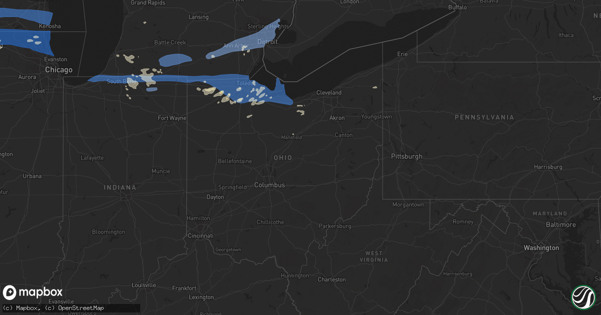
Hail Map in Ohio on July 26, 2023
Get this storm
July 26 map
$229
one time, instant access
Download today. No call, no setup
Keep the $229
Bought the map and want the full workflow? Apply the entire $229 to a subscription within 7 days. None of it is wasted.
Every map, not just this one
This buys you this map. Subscription and you get every map we run, in the markets you choose from a few cities to whole states to nationwide. Plus real-time alerts the moment a storm fires.
Contact data
Name, contact info, occupancy, even credit band for addresses in the footprint. You go from where it hit to who to call.
Become the source they trust
Unlimited branding weather history reports on demand. You already have the documented answer ready for the property owner, and you are the one who showed up with it.
Property data and RoofTrace estimates
Pull up any address you have got, its value and the exact code rules for that jurisdiction, straight from One Click Code. Then RoofTrace estimates the squares, pitch, and roof value, priced the way you price.
Storm reports in Ohio
Ohio
| Date | Description |
|---|---|
| 07/26/20236:26 PM CDT | Portage county dispatch reported numerous trees down near and southeast of the city of ravenna. Time is estimated via radar. |
| 07/26/20234:39 PM CDT | Portion of an apple tree downed. Picture submitted via social media. Time estimated via radar. |
| 07/26/20234:33 PM CDT | Large limb downed with gust front winds. |
| 07/26/20234:32 PM CDT | Tree and wires down on pleasant valley road in willoughby hills. Time estimated via radar. |
| 07/26/20234:32 PM CDT | Trees downed on house in painesville... Causing significant damage to the house. Time estimated via radar. |
| 07/26/20234:28 PM CDT | Tree downed. Picture submitted via social media. Time estimated via radar. |
| 07/26/20234:08 PM CDT | Tree down on n park drive in fairview park. Report via social media. Time estimated via radar. |
| 07/26/20234:06 PM CDT | Poles and wires down on lorain road at sparky lane. |
| 07/26/20234:05 PM CDT | Multiple trees and limbs downed along route 2 between vermillion and huron. Time estimated via radar. |
| 07/26/20233:54 PM CDT | Numerous trees and limbs snapped at plum brook country club. Cover also removed from outdoor pool and bar. Radar signatures show a divergent wind pattern characteristic |
| 07/26/20233:48 PM CDT | Dispatch has received numerous calls for downed trees and wires in erie county... Especially north of the turnpike. |
| 07/26/20233:42 PM CDT | Tree downed along state route 269. Time estimated via radar. |
| 07/26/20233:37 PM CDT | Large tree uprooted on cleveland road. Time estimated via radar. |
| 07/26/20233:37 PM CDT | At least one tree and some limbs down in margaretta twp. Time estimated via radar. |
| 07/26/20233:24 PM CDT | C-man station mrho1 measured a 58 kt wind gust. |
| 07/26/20233:11 PM CDT | Trees and limbs downed. Pictures submitted via social media and time estimated from radar. |
| 07/26/20233:10 PM CDT | Mesonet station sbio1 on south bass island or 9 ne port clinton. |
| 07/26/20232:56 PM CDT | Report from mping: quarter |
| 07/26/20232:49 PM CDT | Numerous trees reported downed in pemberville...especially near the intersection of route 199 and 105. Time estimated via radar. |
| 07/26/20232:44 PM CDT | Numerous trees and power lines down in bowling green. |
| 07/26/20232:39 PM CDT | Large tree uprooted on secor road. |
| 07/26/20232:30 PM CDT | Minor roof damage to a residence. Time estimated via radar. |
| 07/26/20232:29 PM CDT | Damage to a building on airport highway with power poles down. |
| 07/26/20232:27 PM CDT | Large tree limb downed in southwest toledo. Time estimated via radar. |
| 07/26/20232:20 PM CDT | Power poles and wires down in downtown toledo. |
| 07/26/20232:20 PM CDT | Large tree limbs down near monroe street and secor road. |
| 07/26/20232:18 PM CDT | On cr 6 between cr u and u-4 approx 0.5 miles of downed trees and power lines downed and smoking. Time estimated by radar. |
| 07/26/20232:16 PM CDT | Large tree snapped causing damage to a house in point place. |
| 07/26/20232:14 PM CDT | Numerous downed trees and limbs. Time estimated via radar. |
| 07/26/20232:04 PM CDT | Emergency manager reports tree down on the henry/fulton county line. Near the intersection of co rd 13 and county rd a. |
| 07/26/20231:40 PM CDT | Large tree limbs snapped in west unity. Photo on facebook. Tim estimated via radar. |
| 07/26/20231:40 PM CDT | Photos on twitter depict several large tree limbs and one large tree down in edgerton. Near the intersection of north michigan avenue and gas street. Time estimated by |
| 07/25/20237:10 PM CDT | Tree downed onto house... Causing minor damage to the house. |
All States Impacted by Hail Map on July 26, 2023
Cities Impacted by Hail Map on July 26, 2023
- Gratiot, WI
- Apple River, IL
- Elizabeth, IL
- Warren, IL
- Stockton, IL
- McConnell, IL
- Nora, IL
- Dakota, IL
- Kent, IL
- Pearl City, IL
- South Wayne, WI
- Cedarville, IL
- Browntown, WI
- Winslow, IL
- Monroe, WI
- Lena, IL
- Freeport, IL
- Orangeville, IL
- Ridott, IL
- Rock City, IL
- Davis, IL
- Roscoe, IL
- Brodhead, WI
- Shirland, IL
- Rockford, IL
- Winnebago, IL
- Durand, IL
- Juda, WI
- Pecatonica, IL
- Rockton, IL
- South Beloit, IL
- Beloit, WI
- Machesney Park, IL
- Caledonia, IL
- Clinton, WI
- Poplar Grove, IL
- Capron, IL
- Harvard, IL
- Wonder Lake, IL
- Lake Geneva, WI
- Crystal Lake, IL
- Woodstock, IL
- Hebron, IL
- Mchenry, IL
- Walworth, WI
- Island Lake, IL
- Sharon, WI
- Richmond, IL
- Ringwood, IL
- Wauconda, IL
- North Chicago, IL
- Gurnee, IL
- Waukegan, IL
- Libertyville, IL
- Spring Grove, IL
- Round Lake, IL
- Lake Villa, IL
- Lake Bluff, IL
- Grayslake, IL
- Fox Lake, IL
- Great Lakes, IL
- Ingleside, IL
- Mundelein, IL
- Winthrop Harbor, IL
- Genoa City, WI
- Twin Lakes, WI
- Trevor, WI
- Zion, IL
- Wadsworth, IL
- Antioch, IL
- Fontana, WI
- Pleasant Prairie, WI
- Kenosha, WI
- Bristol, WI
- Vernon Hills, IL
- Lake Zurich, IL
- Highland Park, IL
- Highwood, IL
- Deerfield, IL
- Lincolnshire, IL
- Lake Forest, IL
- Garden Prairie, IL
- Marengo, IL
- Union, IL
- Loves Park, IL
- Belvidere, IL
- Barrington, IL
- Cary, IL
- Buffalo Grove, IL
- Glencoe, IL
- Arlington Heights, IL
- Winnetka, IL
- Wheeling, IL
- Northbrook, IL
- Monticello, WI
- Brooklyn, WI
- Belleville, WI
- Evansville, WI
- Albany, WI
- Janesville, WI
- Edgerton, WI
- Stoughton, WI
- Oregon, WI
- Milton, WI
- Fort Atkinson, WI
- Whitewater, WI
- Delavan, WI
- Elkhorn, WI
- Eagle, WI
- Palmyra, WI
- East Troy, WI
- Burlington, WI
- Mukwonago, WI
- Waterford, WI
- Big Bend, WI
- Rochester, WI
- Kansasville, WI
- Muskego, WI
- Union Grove, WI
- Franksville, WI
- Franklin, WI
- Racine, WI
- Caledonia, WI
- Sturtevant, WI
- New Buffalo, MI
- Michigan City, IN
- La Porte, IN
- Beverly Shores, IN
- Three Oaks, MI
- New Carlisle, IN
- Buchanan, MI
- Galien, MI
- Rolling Prairie, IN
- South Bend, IN
- Niles, MI
- Notre Dame, IN
- Granger, IN
- Mishawaka, IN
- Edwardsburg, MI
- Osceola, IN
- Elkhart, IN
- Union, MI
- Bristol, IN
- White Pigeon, MI
- Middlebury, IN
- Goshen, IN
- Howe, IN
- Shipshewana, IN
- Sturgis, MI
- Burr Oak, MI
- Lagrange, IN
- Montpelier, OH
- Orland, IN
- Bronson, MI
- Montgomery, MI
- Fremont, IN
- Angola, IN
- Coldwater, MI
- Camden, MI
- Edon, OH
- Topeka, IN
- Ligonier, IN
- Millersburg, IN
- Wolcottville, IN
- Bloomington, WI
- Knob Noster, MO
- Sweet Springs, MO
- Cherry Valley, IL
- Rockport, IL
- Pleasant Hill, IL
- New Berlin, IL
- Pleasant Plains, IL
- Springfield, IL
- Frankford, MO
- Louisiana, MO
- La Cygne, KS
- Bowling Green, MO
- Greenview, IL
- Lyle, MN
- Glenville, MN
- Campbellsport, WI
- Austin, MN
- Clarksville, MO
- Linden, WI
- Mineral Point, WI
- Rewey, WI
- Pittsfield, IL
- Murrayville, IL
- Winchester, IL
- Bellflower, MO
- Truxton, MO
- High Hill, MO
- Jonesburg, MO
- Rubicon, WI
- Iron Ridge, WI
- Lancaster, WI
- West Bend, WI
- Slinger, WI
- Kewaskum, WI
- Middletown, MO
- Silex, MO
- Warrensburg, MO
- Petersburg, IL
- Dexter, MN
- Sargeant, MN
- Forest City, IL
- Manito, IL
- Topeka, IL
- Green Valley, IL
- Montgomery City, MO
- Vermont, IL
- Rushville, IL
- Astoria, IL
- Muskegon, MI
- Hamburg, IL
- Annada, MO
- Nebo, IL
- Pearl, IL
- Roodhouse, IL
- Juneau, WI
- Horicon, WI
- Hartford, WI
- Allenton, WI
- Hustisford, WI
- Mayville, WI
- Glen Haven, WI
- Scales Mound, IL
- Vandalia, MO
- Laddonia, MO
- Kansas City, MO
- Prairie Village, KS
- Platteville, WI
- Ipava, IL
- Industry, IL
- Concordia, MO
- Liverpool, IL
- Canton, IL
- Delavan, IL
- Lewistown, IL
- Eolia, MO
- Pleasanton, KS
- Mound City, KS
- Wellsville, MO
- Bagley, WI
- Belmont, WI
- Livingston, WI
- Hopkins, MI
- Eldred, IL
- Fieldon, IL
- Pioneer, OH
- Waldron, MI
- Hillsdale, MI
- Osseo, MI
- Pittsford, MI
- Alvordton, OH
- Clarklake, MI
- Cement City, MI
- Brooklyn, MI
- Jackson, MI
- Manchester, MI
- Tipton, MI
- Wauseon, OH
- Lyons, OH
- Morenci, MI
- Hudson, MI
- Fayette, OH
- Sand Creek, MI
- Clayton, MI
- Norvell, MI
- Grass Lake, MI
- Jasper, MI
- Metamora, OH
- Blissfield, MI
- Saline, MI
- Chelsea, MI
- Dexter, MI
- Ann Arbor, MI
- Ypsilanti, MI
- Whitmore Lake, MI
- Canton, MI
- Belleville, MI
- Romulus, MI
- Wayne, MI
- Plymouth, MI
- Northville, MI
- South Lyon, MI
- Westland, MI
- Delta, OH
- Swanton, OH
- Berkey, OH
- Sylvania, OH
- Ottawa Lake, MI
- Riga, MI
- Holland, OH
- Maumee, OH
- Rossford, OH
- Toledo, OH
- Perrysburg, OH
- Northwood, OH
- Monclova, OH
- Walbridge, OH
- Napoleon, MI
- Detroit, MI
- Garden City, MI
- Livonia, MI
- Inkster, MI
- Taylor, MI
- Redford, MI
- Dearborn, MI
- Dearborn Heights, MI
- Southfield, MI
- Farmington, MI
- Lincoln Park, MI
- Melvindale, MI
- Allen Park, MI
- Ecorse, MI
- River Rouge, MI
- Ferndale, MI
- Oak Park, MI
- Huntington Woods, MI
- Larkspur, CO
- Castle Rock, CO
- Royal Oak, MI
- Berkley, MI
- Highland Park, MI
- Pleasant Ridge, MI
- Lambertville, MI
- Temperance, MI
- Erie, MI
- Oregon, OH
- Harbor View, OH
- Millbury, OH
- Curtice, OH
- Franktown, CO
- Warren, MI
- Grosse Pointe, MI
- Hamtramck, MI
- Hazel Park, MI
- Harper Woods, MI
- Saint Clair Shores, MI
- Center Line, MI
- Madison Heights, MI
- Eastpointe, MI
- Roseville, MI
- Clinton Township, MI
- Harrison Township, MI
- Sterling Heights, MI
- Fraser, MI
- Williston, OH
- Martin, OH
- Oak Harbor, OH
- Graytown, OH
- Elbert, CO
- Elmore, OH
- Lacarne, OH
- Port Clinton, OH
- Rocky Ridge, OH
- Genoa, OH
- Clay Center, OH
- Fremont, OH
- Vickery, OH
- Put In Bay, OH
- Middle Bass, OH
- Lakeside Marblehead, OH
- Isle Saint George, OH
- Castalia, OH
- Sandusky, OH
- Kelleys Island, OH
- Whitehouse, OH
- Waterville, OH
- Liberty Center, OH
- Neapolis, OH
- Grand Rapids, OH
- Haskins, OH
- Bowling Green, OH
- Luckey, OH
- Stony Ridge, OH
- Woodville, OH
- Pemberville, OH
- Weston, OH
- Portage, OH
- Tontogany, OH
- Dunbridge, OH
- Lindsey, OH
- Bradner, OH
- Gibsonburg, OH
- Monroeville, OH
- Bellevue, OH
- Clyde, OH
- Wayne, OH
- Troy, MI
- Clawson, MI
- Mount Clemens, MI
- New Baltimore, MI
- Macomb, MI
- Helena, OH
- Calhan, CO
- Ramah, CO
- Milan, OH
- Huron, OH
- Norwalk, OH
- Berlin Heights, OH
- Collins, OH
- Maxwell, NE
- North Platte, NE
- Brady, NE
- Solen, ND
- Flasher, ND
- Mandan, ND
- Bismarck, ND
- Menoken, ND
- Moffit, ND
- Hazelton, ND
- Hayes, SD
- Fort Pierre, SD
- Sherwood, MI
- Mendon, MI
- Colon, MI
- Leonidas, MI
- Fulton, MI
- Athens, MI
- Union City, MI
- Burlington, MI
- Tekonsha, MI
- Quincy, MI
- Litchfield, MI
- Jonesville, MI
- Homer, MI
- Driscoll, ND
- Sterling, ND
- Steele, ND
- Anselmo, NE
- Dawson, ND
- Auxvasse, MO
- Fostoria, OH
- Arcadia, OH
- Alvada, OH
- Midland, SD
- West Unity, OH
- Archbold, OH
- Stryker, OH
- Elsberry, MO
- Salt Lake City, UT
- Dowagiac, MI
- Peyton, CO
- Rush, CO
- Yoder, CO
- McClure, OH
- Hughesville, MO
- Willis, MI
- Dupree, SD
- Hurtsboro, AL
- Bryan, OH
- Napoleon, OH
- Decatur, MI
- Custar, OH
- Colorado Springs, CO
- Athens, IL
- Show Low, AZ
- Winslow, AZ
- Grelton, OH
- Malinta, OH
- Benton Harbor, MI
- Burgoon, OH
- Hugo, CO
- Broken Bow, NE
- Vivian, SD
- Presho, SD
- Eckley, CO
- Yuma, CO
- Vernon, CO
- Joes, CO
- Kirk, CO
- Idalia, CO
- Burlington, CO
- Kanorado, KS
- Goodland, KS
- Saint Francis, KS
- Wray, CO
- Wauneta, NE
- Edson, KS
- McDonald, KS
- Atwood, KS
- Bird City, KS
- Colby, KS
- Brewster, KS
- Levant, KS
- Ludell, KS
- Herndon, KS
- Gem, KS
- Nogales, AZ
- Crookston, MN
- Mcville, ND
- Fort Yates, ND
- Selfridge, ND
- Benkelman, NE
- Arnold, NE
- Parks, NE
- Larimore, ND
- Inkster, ND
- Haigler, NE
- East Brady, PA
- Chicora, PA
- Tappen, ND
- Hayes Center, NE
- Shields, ND
- Vail, AZ
- Benson, AZ
- Niagara, ND
- Karval, CO
- Eagle Butte, SD
- Palisade, NE
- Enders, NE
- Trenton, NE
- Max, NE
- Stratton, NE
- Tucson, AZ
- Olney Springs, CO
- Ordway, CO
- La Junta, CO
- Akron, CO
- Three Rivers, MI
- Constantine, MI
- Jones, MI
- Woodworth, ND
- Trinidad, CO
- Bremen, IN
- Nappanee, IN
- Zeeland, ND
- Wakarusa, IN
- Las Animas, CO
- Andover, OH
- Jefferson, OH
- Rome, OH
- Centreville, MI
- Wakeman, OH
- Oberlin, OH
- Niobrara, NE
- Clearwater, FL
- Rio Rico, AZ
- Hartford, MI
- Cassopolis, MI
- Arapahoe, CO
- Weskan, KS
- Petersburg, ND
- Aneta, ND
- Lawton, MI
- Kit Carson, CO
- Risingsun, OH
- Lower Brule, SD
- Tallassee, AL
- Hague, ND
- New London, OH
- Wellington, OH
- Mansfield, OH
- Mentor, MN
- Erskine, MN
- Mcintosh, MN
- Fosston, MN
- Gully, MN
- Gonvick, MN
- Clearbrook, MN
- Trail, MN
- Coolidge, AZ
- San Tan Valley, AZ
- Florence, AZ
- Queen Creek, AZ
- Gilbert, AZ
- Mesa, AZ
- Chandler, AZ
- Tempe, AZ
- Scottsdale, AZ
- Phoenix, AZ
- Paradise Valley, AZ
- Glendale, AZ
- Peoria, AZ
- Bemidji, MN
- Tenstrike, MN
- Hines, MN
- Blackduck, MN
- Eloy, AZ
- Thief River Falls, MN
- Goodridge, MN
- Gold Canyon, AZ
- Sells, AZ
- Loomis, NE
- Bertrand, NE
- Plummer, MN
- Oklee, MN
- Red Lake Falls, MN
- Rimersburg, PA
- Beltrami, MN
- Williamsfield, OH
- Loman, MN
- Elm Creek, NE
- Fertile, MN
- Grygla, MN
- Northwood, ND
- Marana, AZ
- Puposky, MN
- Holdrege, NE
- Gackle, ND
- Ryegate, MT
- Washburn, WI
- Ontonagon, MI
- White Pine, MI
- Gordon, WI
- Davenport, ND
- Arlington, NE
- North Branch, MN
- Harris, MN
- Finland, MN
- Arivaca, AZ
- Amado, AZ
- Isabella, MN
- Dalbo, MN
- Silver Bay, MN
- Marcus, IA
- Foreston, MN
- Milaca, MN
- Stanchfield, MN
- Cambridge, MN
- Grandy, MN
- Center City, MN
- Lindstrom, MN
- Mount Lemmon, AZ
- Northome, MN
- Squaw Lake, MN
- Max, MN
- Ogilvie, MN
- Braham, MN
- Taylors Falls, MN
- Bergland, MI
- Ewen, MI
- Marenisco, MI
- Minong, WI
- Royal, IA
- Cornucopia, WI
- Hayward, WI
- Schroeder, MN
- Saint Croix Falls, WI
- Shafer, MN
- Peterson, IA
- Sioux Rapids, IA
- Cable, WI
- Solon Springs, WI


