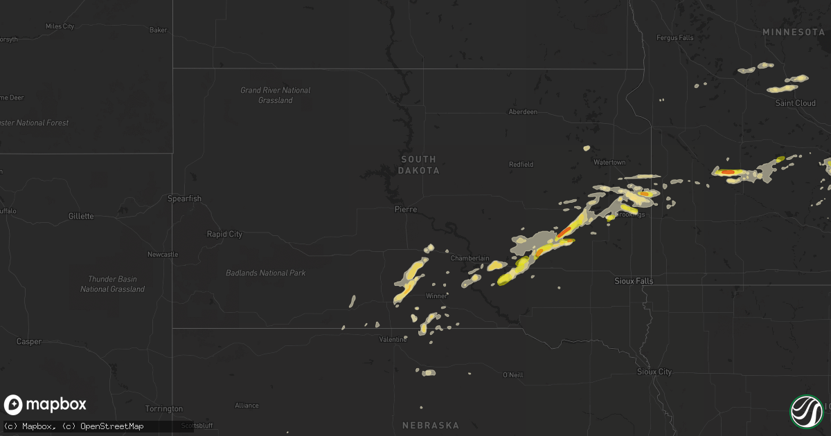
Hail Map in South Dakota on July 25, 2017
Get this storm
July 25 map
$229
one time, instant access
Download today. No call, no setup
Keep the $229
Bought the map and want the full workflow? Apply the entire $229 to a subscription within 7 days. None of it is wasted.
Every map, not just this one
This buys you this map. Subscription and you get every map we run, in the markets you choose from a few cities to whole states to nationwide. Plus real-time alerts the moment a storm fires.
Contact data
Name, contact info, occupancy, even credit band for addresses in the footprint. You go from where it hit to who to call.
Become the source they trust
Unlimited branding weather history reports on demand. You already have the documented answer ready for the property owner, and you are the one who showed up with it.
Property data and RoofTrace estimates
Pull up any address you have got, its value and the exact code rules for that jurisdiction, straight from One Click Code. Then RoofTrace estimates the squares, pitch, and roof value, priced the way you price.
Storm reports in South Dakota
South Dakota
| Date | Description |
|---|---|
| 07/25/20176:35 PM CDT | A local report indicates 60 MPH wind near 3 ENE MILLBORO |
| 07/25/20176:25 PM CDT | Very heavy rain... No hail |
| 07/25/20176:20 PM CDT | A local report indicates 67 MPH wind near 2 ESE OKREEK |
| 07/25/20175:42 PM CDT | A local report indicates 1.00 inch wind near CARTHAGE |
| 07/25/20175:30 PM CDT | Broken car windshields from hail along interstate 90 between mile markers 305 and 308. |
| 07/25/20175:00 PM CDT | A local report indicates 1.00 inch wind near 3 W FEDORA |
| 07/25/20175:00 PM CDT | A local report indicates 60 MPH wind near 3 W FEDORA |
| 07/25/20174:45 PM CDT | Heavy rain and lots of lightning too. |
| 07/25/20174:45 PM CDT | Knocked some small trees down. |
| 07/25/20174:28 PM CDT | Welcomed heavy rain... But not liking the hail. Winds fairly calm. |
| 07/24/20178:54 PM CDT | A local report indicates 1.00 inch wind near 6 ENE LETCHER |
| 07/24/20178:54 PM CDT | A local report indicates 60 MPH wind near 6 ENE LETCHER |
| 07/24/20178:47 PM CDT | A local report indicates 60 MPH wind near LETCHER |
| 07/24/20178:45 PM CDT | A local report indicates 61 MPH wind near 3 N MITCHELL |
| 07/24/20178:32 PM CDT | Trees uprooted and large branches broken. |
| 07/24/20177:50 PM CDT | Estimated wind gusts between 60-70 mph. |
| 07/24/20177:21 PM CDT | A local report indicates 60 MPH wind near WEWELA |
All States Impacted by Hail Map on July 25, 2017
Cities Impacted by Hail Map on July 25, 2017
- Roseau, MN
- Salol, MN
- Renville, MN
- Yerington, NV
- White, SD
- Astoria, SD
- Roosevelt, MN
- Morris, MN
- Kensington, MN
- Iroquois, SD
- Macdoel, CA
- Lake Preston, SD
- De Smet, SD
- Arlington, SD
- Chanhassen, MN
- Minneapolis, MN
- Eden Prairie, MN
- Bruce, SD
- Mission, SD
- Hermanville, MS
- Port Gibson, MS
- Milford, CA
- Janesville, CA
- Carthage, SD
- Fedora, SD
- Artesian, SD
- McClure, IL
- Jonesboro, IL
- Willard, WI
- Carver, MN
- Woonsocket, SD
- Kimball, SD
- White Lake, SD
- Jonesboro, AR
- Wallace, SD
- Bradley, SD
- Holly Springs, MS
- Benton, MO
- Shakopee, MN
- Letcher, SD
- Mount Vernon, SD
- Howard, SD
- Douglasville, GA
- Brookings, SD
- Wood Lake, MN
- Estelline, SD
- Wood, SD
- Okreek, SD
- Winner, SD
- Ideal, SD
- Presho, SD
- Lake Norden, SD
- Nelson, NE
- Pelion, SC
- Swansea, SC
- Wagener, SC
- Salley, SC
- Gary, SD
- Canby, MN
- Clear Lake, SD
- Platte, SD
- Plankinton, SD
- Stickney, SD
- Gordon, WI
- Minong, WI
- De Pere, WI
- Victoria, MN
- Excelsior, MN
- Spring Park, MN
- New Prague, MN
- Prior Lake, MN
- Jordan, MN
- Lakeville, MN
- Minnetonka, MN
- Chaska, MN
- Hopkins, MN
- Saint Paul, MN
- Savage, MN
- Burnsville, MN
- Mound, MN
- Belle Plaine, MN
- Wayzata, MN
- Hendricks, MN
- Brandt, SD
- Cannon Falls, MN
- Mondovi, WI
- Virginia City, NV
- Reno, NV
- Dayton, NV
- Minneota, MN
- Clarkfield, MN
- Taunton, MN
- Porter, MN
- Wellington, NV
- Kelso, TN
- Mulberry, TN
- Twin City, GA
- Waconia, MN
- Wausau, WI
- Long Prairie, MN
- Osakis, MN
- Danbury, WI
- Ivanhoe, MN
- Tryon, NE
- Valentine, NE
- Linton, ND
- Hazelton, ND
- Mountain Rest, SC
- Cannon Ball, ND
- Hector, MN
- Bird Island, MN
- Aurora, SD
- Volga, SD
- Warroad, MN
- Raymond, MN
- Clara City, MN
- Hutchinson, MN
- Winston, GA
- Villa Rica, GA
- Townsend, GA
- Red Wing, MN
- Toronto, SD
- Le Center, MN
- Oldham, SD
- Pepin, WI
- Nelson, WI
- Durand, WI
- Grant, NE
- Kennebec, SD
- Farmington, MN
- Rosemount, MN
- Chamberlain, SD
- Iron River, WI
- Merrill, WI
- La Center, KY
- Kevil, KY
- Colome, SD
- Rice, MN
- Royalton, MN
- Mantorville, MN
- Olivia, MN
- Louise, MS
- Ainsworth, NE
- Johnstown, NE
- Avon, MN
- Albany, MN
- Danube, MN
- Sacred Heart, MN
- Wessington Springs, SD
- Morristown, MN
- Aniwa, WI
- Athens, WI
- Antigo, WI
- Nerstrand, MN
- Randolph, MN
- Kenyon, MN
- Dennison, MN
- Welch, MN
- Northfield, MN
- Dundas, MN
- Faribault, MN
- Webster, MN
- Kilkenny, MN
- Medford, WI
- La Pine, OR
- Ringle, WI
- Arcadia, FL
- Silver Lake, MN
- Glencoe, MN
- Etna, CA
- Forks Of Salmon, CA
- Naples, FL
- Stapleton, NE
- Solen, ND
- Fruithurst, AL
- Muscadine, AL
- Wanamingo, MN
- Pulaski, IL
- Lake City, AR
- Lancaster, MN
- Montrose, MN
- Pulaski, WI
- Burke, SD
- Gregory, SD
- Pukwana, SD
- Mount Pleasant, TN
- Alma, WI
- Little Falls, MN
- Swanville, MN
- Neillsville, WI
- Greenwood, WI
- Monticello, UT
- Hondo, TX
- Hemingway, SC
- North Platte, NE
- Foley, MN
- Pierz, MN
- Knapp, WI
- Independence, WI
- Saint Stephen, MN
- Sauk Rapids, MN
- Sartell, MN
- Saint Joseph, MN
- Holdingford, MN
- Oak Grove, LA
- Hanley Falls, MN
- Cottonwood, MN
- Birnamwood, WI
- Lonsdale, MN
- Somes Bar, CA
- Hayti, SD
- Castlewood, SD
- Inver Grove Heights, MN
- Fort Jones, CA
- Essex, MO
- Bloomfield, MO
- Humbird, WI
- Purdum, NE
- Hamel, MN
- Rochester, MN
- Marshfield, WI
- Arpin, WI
- Arco, MN
- Tyler, MN
- Lawrence, NE
- Waterville, MN
- Cody, NE
- Wells, NV
- Charleston, MO
- Chili, WI
- Winsted, MN
- Erwin, SD
- Bryant, SD
- Green Bay, WI
- Burna, KY
- Hampton, KY
- Granite Falls, MN
- Walhalla, SC
- Brookland, AR
- Saint Francis, SD
- Olmsted, IL
- Bruce, WI
- Osseo, WI
- Fairchild, WI
- Springview, NE
- Westminster, SC
- Bladen, NE
- Sutherland, NE
- Guide Rock, NE
- Wood Lake, NE
- Le Sueur, MN
- Madrid, NE
- Petersburg, TN
- Shelbyville, TN
- Newellton, LA
- Vicksburg, MS
- Tallulah, LA
- Parmelee, SD
- Columbia, TN
- Byron, MN
- Metropolis, IL
- Grand Chain, IL
- Karnak, IL
- Merrillan, WI
- Lewisburg, TN
- Benton, MS
- Hawkins, WI
- Farwell, MN
- Redwood Falls, MN
- Buffalo Lake, MN
- Stewart, MN
- Long Lake, MN
- Lincoln, AL
- Sandstone, MN
- Withee, WI
- Paragould, AR
- Hamill, SD
- Boaz, KY
- West Paducah, KY
- Paducah, KY
- Newport, NE
- Bly, OR
- Madison, AL
- Huntsville, AL
- Blanding, UT
- Snellville, GA
- Loganville, GA
- Alpena, SD
- Hollytree, AL
- Trenton, AL
- Paint Rock, AL
- Oshkosh, NE
- Lemoyne, NE
- Arcadia, WI
- Scott Bar, CA
- Alma Center, WI
- Hixton, WI
- Ramona, SD
- Winfred, SD
- Wiley, CO
- Blair, WI
- Austin, NV
- Salem, KY
- Marion, KY
- Venango, NE
- Crescent, OR
- Cadiz, KY
- Dimock, SD
- Rogerson, ID
- Dumont, MN
- Golconda, IL
- Mills, NE
- Arapahoe, NC
- Nunda, SD
- Garnett, SC
- Estill, SC
- Shawano, WI
- Cologne, MN
- Owatonna, MN
- Waseca, MN
- Askov, MN
- Bruno, MN


