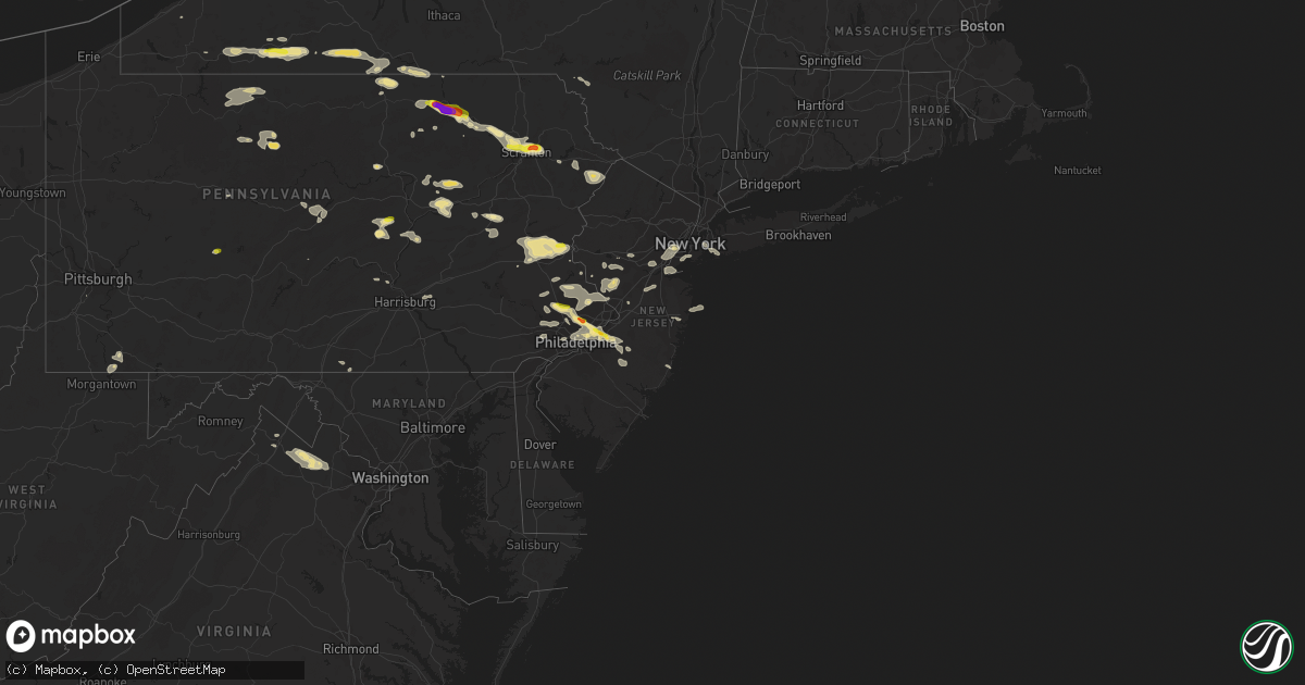
Hail Map in New Jersey on July 25, 2016
Get this storm
July 25 map
$229
one time, instant access
Download today. No call, no setup
Keep the $229
Bought the map and want the full workflow? Apply the entire $229 to a subscription within 7 days. None of it is wasted.
Every map, not just this one
This buys you this map. Subscription and you get every map we run, in the markets you choose from a few cities to whole states to nationwide. Plus real-time alerts the moment a storm fires.
Contact data
Name, contact info, occupancy, even credit band for addresses in the footprint. You go from where it hit to who to call.
Become the source they trust
Unlimited branding weather history reports on demand. You already have the documented answer ready for the property owner, and you are the one who showed up with it.
Property data and RoofTrace estimates
Pull up any address you have got, its value and the exact code rules for that jurisdiction, straight from One Click Code. Then RoofTrace estimates the squares, pitch, and roof value, priced the way you price.
Storm reports in New Jersey
New Jersey
| Date | Description |
|---|---|
| 07/25/20166:15 PM CDT | Large tree and tree limbs down. Time estimated from radar. |
| 07/25/20166:00 PM CDT | A local report indicates 1.50 inch wind near WILLINGBORO |
| 07/25/20165:53 PM CDT | Large tree down and blocking intersection of rancocas and woodlane road. Time estimated from radar. |
| 07/25/20165:50 PM CDT | Large tree limbs down. Time estimated from radar. |
| 07/25/20165:43 PM CDT | Large tree limbs down around the garfield park neighborhood. |
| 07/25/20165:10 PM CDT | Downed tree limbs around the town. Time corrected and estimated from radar. |
| 07/25/20164:56 PM CDT | A local report indicates 58 MPH wind near PORT MONMOUTH |
| 07/25/20164:45 PM CDT | Trees down. Power outages. Time estimated from radar. |
| 07/25/20164:41 PM CDT | Tree split in half on the road at arlington road and north avenue |
| 07/25/20164:40 PM CDT | Large tree limbs down. Time estimated from radar. |
| 07/25/20164:40 PM CDT | Large tree down on knollwood terrace |
| 07/25/20164:38 PM CDT | Multiple trees down |
| 07/25/20164:32 PM CDT | A few trees uprooted. Time estimated by radar. |
| 07/25/20164:27 PM CDT | Large tree with a 13 trunk snapped. |
| 07/25/20164:27 PM CDT | Widespread tree damage vicinty washington valley road and tullo road |
| 07/25/20164:15 PM CDT | Numerous trees down. |
| 07/25/20164:00 PM CDT | Trees and wires reported down |
| 07/25/20163:57 PM CDT | Preakness circle- chimney ripped off house and 2 cars thrown 100 feet. |
| 07/25/20163:55 PM CDT | County communications noted numerous tree damage across the county along with downed poles. |
| 07/25/20163:55 PM CDT | Multiple trees down |
| 07/25/20163:53 PM CDT | Trees down. Time estimated from radar. |
| 07/25/20163:53 PM CDT | Route 29 along river closed to wires and trees down near washington crossing |
| 07/25/20163:45 PM CDT | Numerous trees down. Time estimated from radar. |
| 07/25/20162:37 PM CDT | Numerous trees down |
| 07/24/201610:06 PM CDT | Downed tree branches around the town |
All States Impacted by Hail Map on July 25, 2016
Cities Impacted by Hail Map on July 25, 2016
- Herreid, SD
- Kingston, OK
- Melville, MT
- Peyton, CO
- Zeeland, ND
- Ashley, ND
- Wishek, ND
- Bolivar, NY
- Scio, NY
- Wellsville, NY
- Cuba, NY
- Friendship, NY
- Afton, TX
- Rattan, OK
- Hermosa, SD
- Hill City, SD
- Keystone, SD
- Custer, SD
- Wynnewood, PA
- Upper Darby, PA
- Philadelphia, PA
- Drexel Hill, PA
- Havertown, PA
- Dushore, PA
- Ridgewood, NY
- Ozone Park, NY
- Richmond Hill, NY
- Woodhaven, NY
- Forest Hills, NY
- South Richmond Hill, NY
- Tunkhannock, PA
- Riverton, NJ
- Pennsauken, NJ
- Palmyra, NJ
- Pine City, NY
- Leola, SD
- Helena, MT
- Newcastle, OK
- Dingmans Ferry, PA
- Bushkill, PA
- Hellertown, PA
- Orefield, PA
- Whitehall, PA
- Walnutport, PA
- Bath, PA
- Bethlehem, PA
- Breinigsville, PA
- Coplay, PA
- Cherryville, PA
- Easton, PA
- Northampton, PA
- Schnecksville, PA
- Catasauqua, PA
- Laurys Station, PA
- Germansville, PA
- Slatedale, PA
- Allentown, PA
- Nazareth, PA
- Slatington, PA
- Fogelsville, PA
- Peebles, OH
- Latham, OH
- Hillsboro, OH
- Emporium, PA
- Mount Holly, NJ
- Hoople, ND
- Grafton, ND
- Taylorsville, KY
- Fountainville, PA
- Perkasie, PA
- Dublin, PA
- Doylestown, PA
- Mud Butte, SD
- Elizabeth, NJ
- Canonsburg, PA
- Hammond, MT
- Sulphur Springs, TX
- Creal Springs, IL
- Marion, IL
- Mansfield, PA
- Millerton, PA
- Tioga, PA
- Riverside, NJ
- Beverly, NJ
- Willingboro, NJ
- Rockton, PA
- Whitehouse Station, NJ
- Amistad, NM
- Cleveland, AR
- Okemah, OK
- Hot Springs, SD
- Buffalo Gap, SD
- Prim, AR
- Millville, PA
- Orangeville, PA
- Stillwater, PA
- Benton, PA
- Mount Laurel, NJ
- Moorestown, NJ
- Mosquero, NM
- Ordway, CO
- Crowley, CO
- Olney Springs, CO
- Hopewell, NJ
- Skillman, NJ
- Pennington, NJ
- Wolf Creek, MT
- Scranton, PA
- Laceyville, PA
- Sugar Run, PA
- Quakertown, PA
- Mill Creek, OK
- Tishomingo, OK
- Isabella, MN
- Meshoppen, PA
- Lamar, AR
- Hagarville, AR
- Middleburg, PA
- Mifflinburg, PA
- Millmont, PA
- Gracemont, OK
- Binger, OK
- Anadarko, OK
- Williamson, WV
- Napoleon, ND
- Kintyre, ND
- Higden, AR
- Saint Marys, PA
- Dalhart, TX
- Hopkinsville, KY
- Verona, ND
- Lamoure, ND
- Caney, OK
- Caddo, OK
- Freeburg, PA
- Selinsgrove, PA
- Sunbury, PA
- Dornsife, PA
- Herndon, PA
- Linden, PA
- Cogan Station, PA
- Jersey Shore, PA
- Avon By The Sea, NJ
- Cordell, OK
- Long Eddy, NY
- Roscoe, NY
- Morgantown, WV
- Point Marion, PA
- Smithfield, PA
- Lake Lynn, PA
- Moscow, PA
- Lake Ariel, PA
- Jessup, PA
- Olyphant, PA
- New Braunfels, TX
- San Antonio, TX
- Plymouth Meeting, PA
- Blue Bell, PA
- Fort Washington, PA
- Flourtown, PA
- Lafayette Hill, PA
- Coushatta, LA
- Wellston, OH
- Colorado Springs, CO
- Shunk, PA
- Hazleton, PA
- Tresckow, PA
- Mcadoo, PA
- Junedale, PA
- Weatherly, PA
- Lindley, NY
- Berwyn, PA
- Malvern, PA
- Newtown Square, PA
- Boyce, VA
- Marshall, VA
- Bluemont, VA
- Paris, VA
- Middleburg, VA
- Upperville, VA
- Cashion, OK
- Piedmont, OK
- Tamiment, PA
- Towanda, PA
- Wyalusing, PA
- Beavertown, PA
- South Plainfield, NJ
- Metuchen, NJ
- Piscataway, NJ
- Edison, NJ
- Luther, OK
- Wellston, OK
- Meridian, OK
- Alzada, MT
- Fairchance, PA
- Uniontown, PA
- Winchester, VA
- Huntingdon Valley, PA
- Abington, PA
- Jenkintown, PA
- Glenside, PA
- Dresher, PA
- Calhan, CO
- Batesville, AR
- Garita, NM
- Las Vegas, NM
- Gillett, PA
- Elmira, NY
- Sayre, PA
- Wellsburg, NY
- Leesville, LA
- Keenes, IL
- Fountain, CO
- McLeod, MT
- Big Timber, MT
- Greycliff, MT
- Round Hill, VA
- Berryville, VA
- Tuttle, OK
- Newport, PA
- New Bloomfield, PA
- Avondale, CO
- Buffalo, MT
- Depew, OK
- Junction, IL
- Shawneetown, IL
- Hinton, OK
- Lookeba, OK
- Howell, NJ
- Long Lake, SD
- Havana, AR
- Driftwood, PA
- Payson, AZ
- Troy, PA
- Ulster, PA
- Claude, TX
- Finland, MN
- Babbitt, MN
- Linton, ND
- Andover, NY
- Woodhull, NY
- Cameron, NY
- Painted Post, NY
- Addison, NY
- Greenwood, NY
- Cameron Mills, NY
- Canisteo, NY
- Corning, NY
- Lawrenceville, PA
- Jasper, NY
- Rancocas, NJ
- Bensalem, PA
- Hainesport, NJ
- Colony, OK
- Hydro, OK
- Corn, OK
- Folsom, NM
- Vincentown, NJ
- Hulett, WY
- Grenville, NM
- Ryegate, MT
- Shawmut, MT
- Somerville, NJ
- Lafayette, LA
- Princeton, NJ
- Titusville, NJ
- Lambertville, NJ
- Hillsborough, NJ
- Ringoes, NJ
- Kutztown, PA
- Catawissa, PA
- Danville, PA
- Bloomsburg, PA
- Devine, TX
- Three Bridges, NJ
- Neshanic Station, NJ
- Flemington, NJ
- Flagtown, NJ
- Snow Shoe, PA
- Bellefonte, PA
- Perth Amboy, NJ
- Staten Island, NY
- Mountain View, AR
- Edgemont, AR
- Childress, TX
- Barnegat, NJ
- Guthrie, OK
- Huntingdon, PA
- Belmont, NY
- Mulhall, OK
- Willow Grove, PA
- Lumberton, NJ
- Oreland, PA
- Ambler, PA
- Maysville, KY
- Milnor, ND
- Rapid City, SD
- Myersville, MD
- Elizabethport, NJ
- Bayonne, NJ
- Newark, NJ
- Brooklyn, NY
- Boswell, OK
- Brick, NJ
- Allenwood, NJ
- Manasquan, NJ
- Rahway, NJ
- Carteret, NJ
- Roselle, NJ
- Avenel, NJ
- Linden, NJ
- Boley, OK
- Castle, OK
- Canton, PA
- Randolph, NY
- Livingston, TX
- Campbell, TX
- Schertz, TX
- Factoryville, PA
- Dalton, PA
- Clarks Summit, PA
- Falls, PA
- Hinsdale, NY
- Edmond, OK
- Arcadia, OK
- Faith, SD
- Pickton, TX
- Upper Black Eddy, PA
- Ottsville, PA
- Erwinna, PA
- Waynesboro, PA
- Clayton, NM
- North Wales, PA
- Gwynedd, PA
- Harleysville, PA
- Lansdale, PA
- Norristown, PA
- Hague, ND
- Wayside, TX
- Happy, TX
- Phoenixville, PA
- King Of Prussia, PA
- Wayne, PA
- Bridgeport, PA
- Houston, TX
- Smethport, PA
- Kress, TX
- Pocasset, OK
- Monroeton, PA
- Farmersville, TX
- Nevada, TX
- Princeton Junction, NJ
- Robbinsville, NJ
- Trenton, NJ
- Fishs Eddy, NY
- Mount Pleasant, AR
- Furlong, PA
- Warminster, PA
- Newtown, PA
- Jamison, PA
- Pueblo, CO
- New Hope, PA
- Richboro, PA
- Black Creek, NY
- White House, TN
- Gotebo, OK
- Stone, KY
- McAndrews, KY
- Bee Branch, AR
- Inwood, NY
- Hewlett, NY
- Woodmere, NY
- Rosedale, NY
- Jamaica, NY
- Cedarhurst, NY
- Springfield Gardens, NY
- Lawrence, NY
- South Ozone Park, NY
- Valley Stream, NY
- Eureka, SD
- Stockton, NJ
- Sugarloaf, PA
- Nuremberg, PA
- Rock Glen, PA
- Zion Grove, PA
- Geyser, MT
- Stanford, MT
- Greenville, KY
- Belton, KY
- Collegeville, PA
- Spangler, PA
- Marsteller, PA
- Northern Cambria, PA
- Nicktown, PA
- Fort Towson, OK
- Mehoopany, PA
- Granville Summit, PA
- Columbia Cross Roads, PA
- New Albany, PA
- Wharton, TX
- Leitchfield, KY
- Wewoka, OK
- Mount Jewett, PA
- Eldred, PA
- Bradford, PA
- Turtlepoint, PA
- Rew, PA
- Cyclone, PA
- Lewis Run, PA
- Gifford, PA
- Port Allegany, PA
- Lewistown, MT
- Melissa, TX
- Anna, TX
- Mckinney, TX
- Julian, PA
- Milesburg, PA
- Howard, PA
- Dill City, OK
- Aldie, VA
- Purcellville, VA
- The Plains, VA
- Caneyville, KY
- Kintnersville, PA
- Seaford, DE
- Oklahoma City, OK
- West Union, OH
- Tamaqua, PA
- Hobson, MT
- Franklin, TX
- Pasadena, TX
- Bridgewater, NJ
- Basking Ridge, NJ
- Martinsville, NJ
- Saltillo, TX
- Kill Buck, NY
- Olean, NY
- Allegany, NY
- Salamanca, NY
- Great Valley, NY
- Dent, MN
- Vergas, MN
- Frazee, MN
- Horsham, PA
- Spring House, PA
- Medford, NJ
- Merchantville, NJ
- Pemberton, NJ
- Maple Shade, NJ
- Cheltenham, PA
- Skippack, PA
- Montgomeryville, PA
- Wyncote, PA
- Schwenksville, PA
- Elkins Park, PA
- Paris, KY
- Jamestown, ND
- Greenville, TX
- Spotswood, NJ
- Monroe Township, NJ
- Old Bridge, NJ
- New Tripoli, PA
- Hugo, OK
- La Junta, CO
- Bristow, OK
- Fort Polk, LA
- Cave City, AR
- Branson, CO
- Minco, OK
- Winfield, PA
- Muncy, PA
- Sumner, TX
- Weston, WY
- Brownsville, KY
- Hatboro, PA
- Washington Crossing, PA
- Pipersville, PA
- Warrington, PA
- Hatfield, PA
- Silverdale, PA
- Sellersville, PA
- Line Lexington, PA
- Morrisville, PA
- Hilltown, PA
- Chalfont, PA
- Kindred, ND
- Carencro, LA
- Sunset, LA
- Ramah, CO
- Duncannon, PA
- Sheldon, ND
- Taylor, PA
- Des Moines, NM
- Saint Meinrad, IN
- Ferdinand, IN
- Hughesville, PA
- Greentown, PA
- Newfoundland, PA
- Gordonville, TX
- Loomis, WA
- Stephen, MN
- Strandquist, MN
- Dover, AR
- Moorcroft, WY
- Hawley, PA
- Laurel, DE
- Forestville, NY
- Hershey, PA
- Palmyra, PA
- Hummelstown, PA
- Fairfield, PA
- Lehr, ND
- Athens, PA
- Roosevelt, OK
- Burlington, NJ
- Tennyson, IN
- Judith Gap, MT
- Sawyer, OK
- Barnesville, PA
- Zieglerville, PA
- Telford, PA
- Perkiomenville, PA
- Green Lane, PA
- Wysox, PA
- Carrolltown, PA


