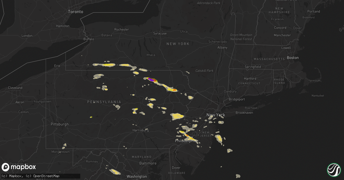
Hail Map on July 25, 2016
Get this storm
July 25 map
$229
one time, instant access
Download today. No call, no setup
Keep the $229
Bought the map and want the full workflow? Apply the entire $229 to a subscription within 7 days. None of it is wasted.
Every map, not just this one
This buys you this map. Subscription and you get every map we run, in the markets you choose from a few cities to whole states to nationwide. Plus real-time alerts the moment a storm fires.
Contact data
Name, contact info, occupancy, even credit band for addresses in the footprint. You go from where it hit to who to call.
Become the source they trust
Unlimited branding weather history reports on demand. You already have the documented answer ready for the property owner, and you are the one who showed up with it.
Property data and RoofTrace estimates
Pull up any address you have got, its value and the exact code rules for that jurisdiction, straight from One Click Code. Then RoofTrace estimates the squares, pitch, and roof value, priced the way you price.
States Impacted by Hail Map on July 25, 2016
Storm reports
Arizona
| Date | Description |
|---|---|
| 07/25/20166:48 PM CDT | Humbug creek raws measured thunderstorm wind gust 61 mph. South of crown king. |
| 07/24/20168:01 PM CDT | Thunderstorm wind gust reported by stanton raws. |
New Jersey
| Date | Description |
|---|---|
| 07/25/20166:15 PM CDT | Large tree and tree limbs down. Time estimated from radar. |
| 07/25/20166:00 PM CDT | A local report indicates 1.50 inch wind near WILLINGBORO |
| 07/25/20165:53 PM CDT | Large tree down and blocking intersection of rancocas and woodlane road. Time estimated from radar. |
| 07/25/20165:50 PM CDT | Large tree limbs down. Time estimated from radar. |
| 07/25/20165:43 PM CDT | Large tree limbs down around the garfield park neighborhood. |
| 07/25/20165:10 PM CDT | Downed tree limbs around the town. Time corrected and estimated from radar. |
| 07/25/20164:56 PM CDT | A local report indicates 58 MPH wind near PORT MONMOUTH |
| 07/25/20164:45 PM CDT | Trees down. Power outages. Time estimated from radar. |
| 07/25/20164:41 PM CDT | Tree split in half on the road at arlington road and north avenue |
| 07/25/20164:40 PM CDT | Large tree limbs down. Time estimated from radar. |
| 07/25/20164:40 PM CDT | Large tree down on knollwood terrace |
| 07/25/20164:38 PM CDT | Multiple trees down |
| 07/25/20164:32 PM CDT | A few trees uprooted. Time estimated by radar. |
| 07/25/20164:27 PM CDT | Large tree with a 13 trunk snapped. |
| 07/25/20164:27 PM CDT | Widespread tree damage vicinty washington valley road and tullo road |
| 07/25/20164:15 PM CDT | Numerous trees down. |
| 07/25/20164:00 PM CDT | Trees and wires reported down |
| 07/25/20163:57 PM CDT | Preakness circle- chimney ripped off house and 2 cars thrown 100 feet. |
| 07/25/20163:55 PM CDT | Multiple trees down |
| 07/25/20163:55 PM CDT | County communications noted numerous tree damage across the county along with downed poles. |
| 07/25/20163:53 PM CDT | Trees down. Time estimated from radar. |
| 07/25/20163:53 PM CDT | Route 29 along river closed to wires and trees down near washington crossing |
| 07/25/20163:45 PM CDT | Numerous trees down. Time estimated from radar. |
| 07/25/20162:37 PM CDT | Numerous trees down |
| 07/24/201610:06 PM CDT | Downed tree branches around the town |
New York
| Date | Description |
|---|---|
| 07/25/20165:35 PM CDT | Tree down on house |
| 07/25/20165:10 PM CDT | Tree limbs broken and power poles broken |
| 07/25/20164:41 PM CDT | Large tree limbs down on dean street and underhill avenue |
| 07/25/20164:25 PM CDT | Numerous branches down on side streets off of merrick road |
| 07/25/20164:15 PM CDT | Numerous trees down. |
| 07/25/20164:14 PM CDT | Multiple trees down |
| 07/25/20164:13 PM CDT | Multiple trees and large branches down |
| 07/25/20163:28 PM CDT | Tree down across lirr tracks at main street |
| 07/25/20162:40 PM CDT | Tree down on grand blvd and trees down in vestal |
| 07/25/20162:05 PM CDT | Trees abd wires down. |
| 07/25/20161:45 PM CDT | Trees and wires down. |
| 07/25/20161:40 PM CDT | Tree downed onto a building |
| 07/25/20161:28 PM CDT | County route 216 closed due to downed tree and wires |
| 07/25/20161:26 PM CDT | Large tree limbs downed |
| 07/25/201612:50 PM CDT | Tree down on powerline on dodge road |
| 07/25/201612:28 PM CDT | Trees and wires down |
| 07/25/201612:18 PM CDT | Trees and wires down |
| 07/25/201612:10 PM CDT | Trees and wires down |
| 07/25/201611:50 AM CDT | Tree across route 474 in blockville |
| 07/25/201611:50 AM CDT | Trees and wires down from roscoe to liberty to monticello. |
| 07/25/201611:44 AM CDT | Trees and wires down |
| 07/25/201611:40 AM CDT | Tree down on wires |
| 07/25/201611:30 AM CDT | Multiple areas of snapped and uprooted trees |
| 07/25/201610:53 AM CDT | Tree downed on wires |
| 07/25/20168:30 AM CDT | Trees and wires down |
| 07/25/20168:16 AM CDT | Tree on powerline near intersection of routes 21 and 245 |
| 07/25/20168:15 AM CDT | Tree on powerline near intersection of routes 21 and 245 |
| 07/25/20167:35 AM CDT | Trees and wires down on exchange road |
| 07/25/20167:35 AM CDT | Trees and wires down on perry road |
| 07/25/20167:18 AM CDT | Tree down on irish road between finch and hayes hollow roads |
South Dakota
| Date | Description |
|---|---|
| 07/25/20166:45 AM CDT | Was mostly nickel sized hail with some as large as quarters. The hail was still on the ground at 845 this morning. . |
Minnesota
| Date | Description |
|---|---|
| 07/25/20165:42 AM CDT | Power line down on county road 6. |
| 07/25/20165:32 AM CDT | Two power lines fell on two motorhomes. |
| 07/25/20165:00 AM CDT | Multiple trees snapped near base. |
Ohio
| Date | Description |
|---|---|
| 07/25/20165:00 PM CDT | Tree down on blue creek road. |
| 07/25/20164:49 PM CDT | One tree down blocking oh-552 near lake white state park. Size unknown. |
| 07/25/20164:49 PM CDT | One tree down on a power line. No size given but waverly fire department is responding. Time estimated based on radar. |
| 07/25/20164:14 PM CDT | Barn damaged... Windows shattered... Trees on driveway... Vehicle damaged on russellville-arnheim rd. |
West Virginia
| Date | Description |
|---|---|
| 07/25/20165:09 PM CDT | Trees down |
| 07/25/201612:44 PM CDT | Large tree uprooted on diana road. |
Oklahoma
| Date | Description |
|---|---|
| 07/24/20167:19 PM CDT | Fences blown down on hwy 37. |
| 07/24/20167:05 PM CDT | 6 foot and 30 foot trees downed. |
Arkansas
| Date | Description |
|---|---|
| 07/24/20167:00 PM CDT | Roof damage to a home was reported in melbourne. |
Utah
| Date | Description |
|---|---|
| 07/25/20166:00 PM CDT | Reports of a dozen downed power lines resulting from a microburst. Time is approximate. |
| 07/24/201610:35 PM CDT | Dry microburst. |
Virginia
| Date | Description |
|---|---|
| 07/25/20164:45 PM CDT | 5 to 6 inch live tree limb fell out of tree and crushed flower garden. |
| 07/25/20164:27 PM CDT | Multiple trees down in aldie |
| 07/25/20164:26 PM CDT | Trees down on foxcroft rd |
| 07/25/20164:24 PM CDT | Tree down on st. Louis rd |
| 07/25/20164:15 PM CDT | Numerous trees and large limbs down along snickersville turnpike near jeb stuart rd |
| 07/25/20163:40 PM CDT | A local report indicates 58 MPH wind near 2 SE WINCHESTER |
| 07/25/20162:16 PM CDT | Several large trees snapped and uprooted in area. Some into homes. Carport wind damage. |
| 07/24/201611:25 PM CDT | Tree down across academy st. Time radar estimated. |
Connecticut
| Date | Description |
|---|---|
| 07/25/20162:58 PM CDT | Wires down on amity road |
| 07/25/20162:49 PM CDT | Trees and wires down on maplewood road |
| 07/25/20162:37 PM CDT | Multiple trees and wires down around town |
| 07/25/20162:19 PM CDT | Tree down on edgewood road |
| 07/25/20162:19 PM CDT | Trees and wires down on pocono road |
Pennsylvania
| Date | Description |
|---|---|
| 07/25/20166:59 PM CDT | Trees down. |
| 07/25/20165:44 PM CDT | Trees down near palmyra. |
| 07/25/20165:32 PM CDT | Trees down near dehart dam. |
| 07/25/20165:10 PM CDT | Trees down on route 34 in howe township. |
| 07/25/20165:05 PM CDT | Some trees down. Time estimated from radar. |
| 07/25/20165:02 PM CDT | A local report indicates 1.00 inch wind near 1 S LANSDALE |
| 07/25/20165:01 PM CDT | Trees down near new bloomfield. |
| 07/25/20165:00 PM CDT | A local report indicates 1.00 inch wind near COATESVILLE |
| 07/25/20164:55 PM CDT | Trees on wires |
| 07/25/20164:41 PM CDT | Multiple trees down in springhill township |
| 07/25/20164:40 PM CDT | Large tree limbs down. Time estimated from radar. |
| 07/25/20164:30 PM CDT | Trees down in decatur township. |
| 07/25/20164:30 PM CDT | Several reports of trees down across southern northumberland county. |
| 07/25/20164:28 PM CDT | Tree down on road. |
| 07/25/20164:27 PM CDT | Trees and wires down. Time estimated from radar. |
| 07/25/20164:25 PM CDT | Multiple trees down in smithfield |
| 07/25/20164:18 PM CDT | Trees down in bratton township. |
| 07/25/20164:15 PM CDT | Trees down in oliver township. |
| 07/25/20164:15 PM CDT | Tree on roadway |
| 07/25/20164:12 PM CDT | Multiple trees down on waltersburg road and constantine road |
| 07/25/20164:11 PM CDT | 2 trees reported down near pecks pond. |
| 07/25/20164:11 PM CDT | Tree on road. |
| 07/25/20164:09 PM CDT | Trees down in menno township. |
| 07/25/20163:59 PM CDT | Trees and wires down |
| 07/25/20163:50 PM CDT | Large limbs reported down near petersburg. |
| 07/25/20163:45 PM CDT | Wires down on emert lane |
| 07/25/20163:45 PM CDT | Tree down on fox hollow road |
| 07/25/20163:44 PM CDT | Multiple trees down on waltersburg road and constantine road...corrected for time |
| 07/25/20163:43 PM CDT | Trees down in rush and ralpho townships near elysburg. |
| 07/25/20163:40 PM CDT | Spotty tree damge across the county. Several lightning strikes. |
| 07/25/20163:40 PM CDT | Tree down on i 80 westbound at mm 174 |
| 07/25/20163:40 PM CDT | Trees and wires down. Time estimated from radar. |
| 07/25/20163:38 PM CDT | Tree on car |
| 07/25/20163:37 PM CDT | Trees and wires down along nittany ridge road in walker township. |
| 07/25/20163:34 PM CDT | Large trees down near almedia. |
| 07/25/20163:34 PM CDT | Tree on car. |
| 07/25/20163:30 PM CDT | Some trees down. Time estimated from radar. |
| 07/25/20163:28 PM CDT | Multiple reports of trees down across route 422 north. |
| 07/25/20163:28 PM CDT | Tree down along the side of a house |
| 07/25/20163:27 PM CDT | Tree and wires down on fox hollow road at speed lane |
| 07/25/20163:27 PM CDT | Trees and wires down on renovo road |
| 07/25/20163:26 PM CDT | Trees and wires down along eagle valley road in boggs township. |
| 07/25/20163:25 PM CDT | Spotty tree damage. |
| 07/25/20163:25 PM CDT | Brush fire caused by down power lines along georgetown road |
| 07/25/20163:24 PM CDT | Tree down on pine mountain road |
| 07/25/20163:24 PM CDT | Multiple trees down in perryopolis |
| 07/25/20163:24 PM CDT | Trees down and cattle feeder thrown 50 yards |
| 07/25/20163:20 PM CDT | A local report indicates 68 MPH wind near S BATH |
| 07/25/20163:20 PM CDT | Part of roof blown onto residence |
| 07/25/20163:20 PM CDT | A local report indicates 62 MPH wind near PERRYOPOLIS |
| 07/25/20163:18 PM CDT | Tree and power lines on road. |
| 07/25/20163:18 PM CDT | Trees down on spruce run road |
| 07/25/20163:15 PM CDT | Spotty trees damage. |
| 07/25/20163:13 PM CDT | Trees and wires down at intersection of keystone central drive and orner road |
| 07/25/20163:11 PM CDT | Tree brought wires down on beagle road |
| 07/25/20163:10 PM CDT | Multiple reports of trees and wires down. |
| 07/25/20163:05 PM CDT | Tree down on water street |
| 07/25/20163:02 PM CDT | Trees down on route 120 |
| 07/25/20163:02 PM CDT | Trees and wires down |
| 07/25/20163:00 PM CDT | Trees down |
| 07/25/20163:00 PM CDT | Trees down |
| 07/25/20162:57 PM CDT | Trees down in lock haven...some 20 inches in diameter. |
| 07/25/20162:55 PM CDT | Trees and wires down |
| 07/25/20162:55 PM CDT | Sporatic tree damage tunkhannock to mehoopany. |
| 07/25/20162:54 PM CDT | Quarter sized hail reported. |
| 07/25/20162:50 PM CDT | Numerous trees down in indiana county |
| 07/25/20162:50 PM CDT | Trees down near clearfield. |
| 07/25/20162:45 PM CDT | Trees down in lawrence twp. |
| 07/25/20162:42 PM CDT | Multpile trees down throughout southern indiana county |
| 07/25/20162:38 PM CDT | Multiple trees down throughout central indiana county |
| 07/25/20162:17 PM CDT | Trees down and barn roof removed. |
| 07/25/20162:16 PM CDT | Trees down at cottonwood dr and heartwood dr |
| 07/25/20162:16 PM CDT | Numerous trees down near south park |
| 07/25/20162:15 PM CDT | A local report indicates 1.50 inch wind near MONROETON |
| 07/25/20162:14 PM CDT | Barn damaged. |
| 07/25/20162:13 PM CDT | Trees down. |
| 07/25/20162:10 PM CDT | Roof blown off barn. |
| 07/25/20162:10 PM CDT | Multiple trees and wires down in bethel park. |
| 07/25/20162:10 PM CDT | Multiple trees and power lines down in around upper st. Clair |
| 07/25/20162:10 PM CDT | A local report indicates 1.25 inch wind near 1 S TOWANDA |
| 07/25/20162:09 PM CDT | A local report indicates 1.25 inch wind near TOWANDA |
| 07/25/20162:08 PM CDT | Multiple trees down and uprooted in whitehall |
| 07/25/20162:06 PM CDT | Numerous trees down in monroeton. |
| 07/25/20162:06 PM CDT | Multiple trees down. |
| 07/25/20162:06 PM CDT | Non certified weather equipment. |
| 07/25/20161:39 PM CDT | Trees and wires down. |
| 07/25/20161:28 PM CDT | One tree down on rt 30 near hookstown. |
| 07/25/20161:18 PM CDT | Trees down along route 646 in keating township. |
| 07/25/20161:15 PM CDT | Trees down on front street |
| 07/25/201612:53 PM CDT | Multiple trees and wires down and collapsed residential porch on old rt 422 in franklin twp |
| 07/24/20167:18 PM CDT | Tree down. |
Colorado
| Date | Description |
|---|---|
| 07/25/20162:24 PM CDT | A local report indicates 60 MPH wind near 3 NE CASTLE ROCK |
| 07/24/20167:08 PM CDT | Asos station pueblo airport /pub/. |
Cities Impacted by Hail Map on July 25, 2016
- Herreid, SD
- Kingston, OK
- Melville, MT
- Peyton, CO
- Zeeland, ND
- Ashley, ND
- Wishek, ND
- Bolivar, NY
- Scio, NY
- Wellsville, NY
- Cuba, NY
- Friendship, NY
- Afton, TX
- Rattan, OK
- Hermosa, SD
- Hill City, SD
- Keystone, SD
- Custer, SD
- Wynnewood, PA
- Upper Darby, PA
- Philadelphia, PA
- Drexel Hill, PA
- Havertown, PA
- Dushore, PA
- Ridgewood, NY
- Ozone Park, NY
- Richmond Hill, NY
- Woodhaven, NY
- Forest Hills, NY
- South Richmond Hill, NY
- Tunkhannock, PA
- Riverton, NJ
- Pennsauken, NJ
- Palmyra, NJ
- Pine City, NY
- Leola, SD
- Helena, MT
- Newcastle, OK
- Dingmans Ferry, PA
- Bushkill, PA
- Hellertown, PA
- Orefield, PA
- Whitehall, PA
- Walnutport, PA
- Bath, PA
- Bethlehem, PA
- Breinigsville, PA
- Coplay, PA
- Cherryville, PA
- Easton, PA
- Northampton, PA
- Schnecksville, PA
- Catasauqua, PA
- Laurys Station, PA
- Germansville, PA
- Slatedale, PA
- Allentown, PA
- Nazareth, PA
- Slatington, PA
- Fogelsville, PA
- Peebles, OH
- Latham, OH
- Hillsboro, OH
- Emporium, PA
- Mount Holly, NJ
- Hoople, ND
- Grafton, ND
- Taylorsville, KY
- Fountainville, PA
- Perkasie, PA
- Dublin, PA
- Doylestown, PA
- Mud Butte, SD
- Elizabeth, NJ
- Canonsburg, PA
- Hammond, MT
- Sulphur Springs, TX
- Creal Springs, IL
- Marion, IL
- Mansfield, PA
- Millerton, PA
- Tioga, PA
- Riverside, NJ
- Beverly, NJ
- Willingboro, NJ
- Rockton, PA
- Whitehouse Station, NJ
- Amistad, NM
- Cleveland, AR
- Okemah, OK
- Hot Springs, SD
- Buffalo Gap, SD
- Prim, AR
- Millville, PA
- Orangeville, PA
- Stillwater, PA
- Benton, PA
- Mount Laurel, NJ
- Moorestown, NJ
- Mosquero, NM
- Ordway, CO
- Crowley, CO
- Olney Springs, CO
- Hopewell, NJ
- Skillman, NJ
- Pennington, NJ
- Wolf Creek, MT
- Scranton, PA
- Laceyville, PA
- Sugar Run, PA
- Quakertown, PA
- Mill Creek, OK
- Tishomingo, OK
- Isabella, MN
- Meshoppen, PA
- Lamar, AR
- Hagarville, AR
- Middleburg, PA
- Mifflinburg, PA
- Millmont, PA
- Gracemont, OK
- Binger, OK
- Anadarko, OK
- Williamson, WV
- Napoleon, ND
- Kintyre, ND
- Higden, AR
- Saint Marys, PA
- Dalhart, TX
- Hopkinsville, KY
- Verona, ND
- Lamoure, ND
- Caney, OK
- Caddo, OK
- Freeburg, PA
- Selinsgrove, PA
- Sunbury, PA
- Dornsife, PA
- Herndon, PA
- Linden, PA
- Cogan Station, PA
- Jersey Shore, PA
- Avon By The Sea, NJ
- Cordell, OK
- Long Eddy, NY
- Roscoe, NY
- Morgantown, WV
- Point Marion, PA
- Smithfield, PA
- Lake Lynn, PA
- Moscow, PA
- Lake Ariel, PA
- Jessup, PA
- Olyphant, PA
- New Braunfels, TX
- San Antonio, TX
- Plymouth Meeting, PA
- Blue Bell, PA
- Fort Washington, PA
- Flourtown, PA
- Lafayette Hill, PA
- Coushatta, LA
- Wellston, OH
- Colorado Springs, CO
- Shunk, PA
- Hazleton, PA
- Tresckow, PA
- Mcadoo, PA
- Junedale, PA
- Weatherly, PA
- Lindley, NY
- Berwyn, PA
- Malvern, PA
- Newtown Square, PA
- Boyce, VA
- Marshall, VA
- Bluemont, VA
- Paris, VA
- Middleburg, VA
- Upperville, VA
- Cashion, OK
- Piedmont, OK
- Tamiment, PA
- Towanda, PA
- Wyalusing, PA
- Beavertown, PA
- South Plainfield, NJ
- Metuchen, NJ
- Piscataway, NJ
- Edison, NJ
- Luther, OK
- Wellston, OK
- Meridian, OK
- Alzada, MT
- Fairchance, PA
- Uniontown, PA
- Winchester, VA
- Huntingdon Valley, PA
- Abington, PA
- Jenkintown, PA
- Glenside, PA
- Dresher, PA
- Calhan, CO
- Batesville, AR
- Garita, NM
- Las Vegas, NM
- Gillett, PA
- Elmira, NY
- Sayre, PA
- Wellsburg, NY
- Leesville, LA
- Keenes, IL
- Fountain, CO
- McLeod, MT
- Big Timber, MT
- Greycliff, MT
- Round Hill, VA
- Berryville, VA
- Tuttle, OK
- Newport, PA
- New Bloomfield, PA
- Avondale, CO
- Buffalo, MT
- Depew, OK
- Junction, IL
- Shawneetown, IL
- Hinton, OK
- Lookeba, OK
- Howell, NJ
- Long Lake, SD
- Havana, AR
- Driftwood, PA
- Payson, AZ
- Troy, PA
- Ulster, PA
- Claude, TX
- Finland, MN
- Babbitt, MN
- Linton, ND
- Andover, NY
- Woodhull, NY
- Cameron, NY
- Painted Post, NY
- Addison, NY
- Greenwood, NY
- Cameron Mills, NY
- Canisteo, NY
- Corning, NY
- Lawrenceville, PA
- Jasper, NY
- Rancocas, NJ
- Bensalem, PA
- Hainesport, NJ
- Colony, OK
- Hydro, OK
- Corn, OK
- Folsom, NM
- Vincentown, NJ
- Hulett, WY
- Grenville, NM
- Ryegate, MT
- Shawmut, MT
- Somerville, NJ
- Lafayette, LA
- Princeton, NJ
- Titusville, NJ
- Lambertville, NJ
- Hillsborough, NJ
- Ringoes, NJ
- Kutztown, PA
- Catawissa, PA
- Danville, PA
- Bloomsburg, PA
- Devine, TX
- Three Bridges, NJ
- Neshanic Station, NJ
- Flemington, NJ
- Flagtown, NJ
- Snow Shoe, PA
- Bellefonte, PA
- Perth Amboy, NJ
- Staten Island, NY
- Mountain View, AR
- Edgemont, AR
- Childress, TX
- Barnegat, NJ
- Guthrie, OK
- Huntingdon, PA
- Belmont, NY
- Mulhall, OK
- Willow Grove, PA
- Lumberton, NJ
- Oreland, PA
- Ambler, PA
- Maysville, KY
- Milnor, ND
- Rapid City, SD
- Myersville, MD
- Elizabethport, NJ
- Bayonne, NJ
- Newark, NJ
- Brooklyn, NY
- Boswell, OK
- Brick, NJ
- Allenwood, NJ
- Manasquan, NJ
- Rahway, NJ
- Carteret, NJ
- Roselle, NJ
- Avenel, NJ
- Linden, NJ
- Boley, OK
- Castle, OK
- Canton, PA
- Randolph, NY
- Livingston, TX
- Campbell, TX
- Schertz, TX
- Factoryville, PA
- Dalton, PA
- Clarks Summit, PA
- Falls, PA
- Hinsdale, NY
- Edmond, OK
- Arcadia, OK
- Faith, SD
- Pickton, TX
- Upper Black Eddy, PA
- Ottsville, PA
- Erwinna, PA
- Waynesboro, PA
- Clayton, NM
- North Wales, PA
- Gwynedd, PA
- Harleysville, PA
- Lansdale, PA
- Norristown, PA
- Hague, ND
- Wayside, TX
- Happy, TX
- Phoenixville, PA
- King Of Prussia, PA
- Wayne, PA
- Bridgeport, PA
- Houston, TX
- Smethport, PA
- Kress, TX
- Pocasset, OK
- Monroeton, PA
- Farmersville, TX
- Nevada, TX
- Princeton Junction, NJ
- Robbinsville, NJ
- Trenton, NJ
- Fishs Eddy, NY
- Mount Pleasant, AR
- Furlong, PA
- Warminster, PA
- Newtown, PA
- Jamison, PA
- Pueblo, CO
- New Hope, PA
- Richboro, PA
- Black Creek, NY
- White House, TN
- Gotebo, OK
- Stone, KY
- McAndrews, KY
- Bee Branch, AR
- Inwood, NY
- Hewlett, NY
- Woodmere, NY
- Rosedale, NY
- Jamaica, NY
- Cedarhurst, NY
- Springfield Gardens, NY
- Lawrence, NY
- South Ozone Park, NY
- Valley Stream, NY
- Eureka, SD
- Stockton, NJ
- Sugarloaf, PA
- Nuremberg, PA
- Rock Glen, PA
- Zion Grove, PA
- Geyser, MT
- Stanford, MT
- Greenville, KY
- Belton, KY
- Collegeville, PA
- Spangler, PA
- Marsteller, PA
- Northern Cambria, PA
- Nicktown, PA
- Fort Towson, OK
- Mehoopany, PA
- Granville Summit, PA
- Columbia Cross Roads, PA
- New Albany, PA
- Wharton, TX
- Leitchfield, KY
- Wewoka, OK
- Mount Jewett, PA
- Eldred, PA
- Bradford, PA
- Turtlepoint, PA
- Rew, PA
- Cyclone, PA
- Lewis Run, PA
- Gifford, PA
- Port Allegany, PA
- Lewistown, MT
- Melissa, TX
- Anna, TX
- Mckinney, TX
- Julian, PA
- Milesburg, PA
- Howard, PA
- Dill City, OK
- Aldie, VA
- Purcellville, VA
- The Plains, VA
- Caneyville, KY
- Kintnersville, PA
- Seaford, DE
- Oklahoma City, OK
- West Union, OH
- Tamaqua, PA
- Hobson, MT
- Franklin, TX
- Pasadena, TX
- Bridgewater, NJ
- Basking Ridge, NJ
- Martinsville, NJ
- Saltillo, TX
- Kill Buck, NY
- Olean, NY
- Allegany, NY
- Salamanca, NY
- Great Valley, NY
- Dent, MN
- Vergas, MN
- Frazee, MN
- Horsham, PA
- Spring House, PA
- Medford, NJ
- Merchantville, NJ
- Pemberton, NJ
- Maple Shade, NJ
- Cheltenham, PA
- Skippack, PA
- Montgomeryville, PA
- Wyncote, PA
- Schwenksville, PA
- Elkins Park, PA
- Paris, KY
- Jamestown, ND
- Greenville, TX
- Spotswood, NJ
- Monroe Township, NJ
- Old Bridge, NJ
- New Tripoli, PA
- Hugo, OK
- La Junta, CO
- Bristow, OK
- Fort Polk, LA
- Cave City, AR
- Branson, CO
- Minco, OK
- Winfield, PA
- Muncy, PA
- Sumner, TX
- Weston, WY
- Brownsville, KY
- Hatboro, PA
- Washington Crossing, PA
- Pipersville, PA
- Warrington, PA
- Hatfield, PA
- Silverdale, PA
- Sellersville, PA
- Line Lexington, PA
- Morrisville, PA
- Hilltown, PA
- Chalfont, PA
- Kindred, ND
- Carencro, LA
- Sunset, LA
- Ramah, CO
- Duncannon, PA
- Sheldon, ND
- Taylor, PA
- Des Moines, NM
- Saint Meinrad, IN
- Ferdinand, IN
- Hughesville, PA
- Greentown, PA
- Newfoundland, PA
- Gordonville, TX
- Loomis, WA
- Stephen, MN
- Strandquist, MN
- Dover, AR
- Moorcroft, WY
- Hawley, PA
- Laurel, DE
- Forestville, NY
- Hershey, PA
- Palmyra, PA
- Hummelstown, PA
- Fairfield, PA
- Lehr, ND
- Athens, PA
- Roosevelt, OK
- Burlington, NJ
- Tennyson, IN
- Judith Gap, MT
- Sawyer, OK
- Barnesville, PA
- Zieglerville, PA
- Telford, PA
- Perkiomenville, PA
- Green Lane, PA
- Wysox, PA
- Carrolltown, PA