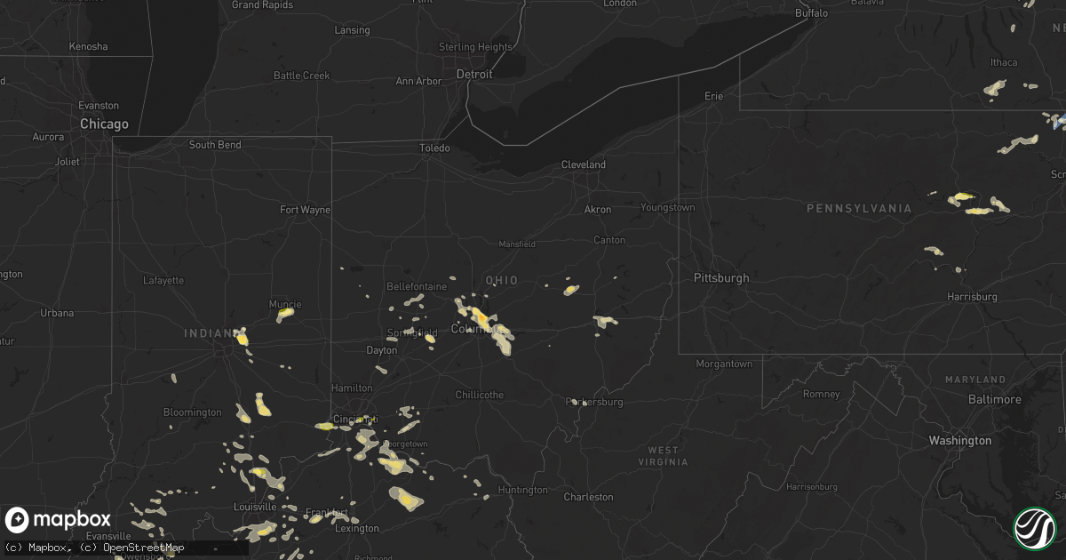
Hail Map in Ohio on July 24, 2023
Get this storm
July 24 map
$229
one time, instant access
Download today. No call, no setup
Keep the $229
Bought the map and want the full workflow? Apply the entire $229 to a subscription within 7 days. None of it is wasted.
Every map, not just this one
This buys you this map. Subscription and you get every map we run, in the markets you choose from a few cities to whole states to nationwide. Plus real-time alerts the moment a storm fires.
Contact data
Name, contact info, occupancy, even credit band for addresses in the footprint. You go from where it hit to who to call.
Become the source they trust
Unlimited branding weather history reports on demand. You already have the documented answer ready for the property owner, and you are the one who showed up with it.
Property data and RoofTrace estimates
Pull up any address you have got, its value and the exact code rules for that jurisdiction, straight from One Click Code. Then RoofTrace estimates the squares, pitch, and roof value, priced the way you price.
Storm reports in Ohio
Ohio
| Date | Description |
|---|---|
| 07/24/20236:59 PM CDT | A local report indicates 1.00 inch wind near Minerva Park |
| 07/24/20236:55 PM CDT | Report from mping: quarter |
| 07/24/20236:55 PM CDT | Report from mping: quarter |
| 07/24/20236:50 PM CDT | A local report indicates 1.50 inch wind near Minerva Park |
| 07/24/20236:45 PM CDT | Viewed from photo on social media. |
| 07/24/20236:42 PM CDT | Trees on house on both south 16th street and wilson avenue. Time estimated from radar. |
| 07/24/20236:41 PM CDT | Corrects previous tstm wnd dmg report from 3 n dublin. Large tree down on a house. |
| 07/24/20236:21 PM CDT | Sheriffs office reports multiple trees down across the county |
| 07/24/20236:18 PM CDT | A few trees were downed. |
| 07/24/20235:38 PM CDT | Large branch down. Time estimated from radar. |
| 07/24/20235:28 PM CDT | Report from mping: quarter |
| 07/24/20234:55 PM CDT | Pole down in the richwood area. |
| 07/24/20234:23 PM CDT | Report from mping: quarter |
| 07/24/20234:06 PM CDT | Report from mping: quarter |
| 07/24/20234:04 PM CDT | At lunken airport. |
| 07/24/20234:03 PM CDT | Tree down due to thunderstorm winds. Time estimated from radar. |
| 07/23/202310:20 PM CDT | Multiple trees reported down in the pomeroy and salisbury township area. Time estimated from radar. |
| 07/23/20239:59 PM CDT | Report of tree down along state route 265 east of lore city. Time estimated based on radar. |
| 07/23/20239:20 PM CDT | Tree reported down near state route 93. |
| 07/23/20239:15 PM CDT | Multiple reports of trees and lines down in crooksville. |
| 07/23/20239:15 PM CDT | Tree reported down on buzzards glory road. |
| 07/23/20239:10 PM CDT | A tree was downed along state route 180. Time estimated from radar. |
| 07/23/20239:05 PM CDT | Tree and power line reported down. |
| 07/23/20238:55 PM CDT | A tree was downed near the intersection of stage and dupler roads. Time estimated from radar. |
| 07/23/20238:13 PM CDT | Numerous trees downed in the lancaster area. |
| 07/23/20238:01 PM CDT | Tree downed on top of a home... Causing roof damage to the home. Time of event estimated from radar. |
| 07/23/20237:49 PM CDT | A local report indicates 1.00 inch wind near 2 SSE Reynoldsburg |
| 07/23/20237:48 PM CDT | A local report indicates 1.00 inch wind near 1 SSE Reynoldsburg |
| 07/23/20237:15 PM CDT | Large tree down on a house. |
All States Impacted by Hail Map on July 24, 2023
Cities Impacted by Hail Map on July 24, 2023
- Leavenworth, KS
- Basehor, KS
- Kansas City, KS
- Kansas City, MO
- Riverside, MO
- Independence, MO
- Lees Summit, MO
- Greenwood, MO
- Lone Jack, MO
- Grain Valley, MO
- Pleasant Hill, MO
- Blue Springs, MO
- Kingsville, MO
- Holden, MO
- Creighton, MO
- Butler, MO
- Urich, MO
- Montrose, MO
- Clinton, MO
- Archie, MO
- Adrian, MO
- Rich Hill, MO
- Appleton City, MO
- Richards, MO
- Walker, MO
- Schell City, MO
- Osceola, MO
- Rockville, MO
- Nevada, MO
- Lowry City, MO
- Deepwater, MO
- El Dorado Springs, MO
- Montrose, PA
- New Milford, PA
- Hallstead, PA
- Susquehanna, PA
- Harford, PA
- South Gibson, PA
- Kingsley, PA
- Jackson, PA
- Thompson, PA
- Windsor, NY
- Montgomery, PA
- Williamsport, PA
- Muncy, PA
- Schroon Lake, NY
- Ellington, MO
- Redford, MO
- McLouth, KS
- Lawrence, KS
- Winona, MO
- King City, MO
- Guilford, MO
- Maysville, MO
- Wyalusing, PA
- Lawton, PA
- Laceyville, PA
- Lenexa, KS
- La Cygne, KS
- Amsterdam, MO
- Van Buren, MO
- Lynchburg, OH
- Mount Orab, OH
- Fayetteville, OH
- New Albany, PA
- Monroeton, PA
- Rome, NY
- Freeman, MO
- Cleveland, MO
- Medina, NY
- Lyndonville, NY
- Eudora, KS
- Wellsville, KS
- Edgerton, KS
- Amity, MO
- Lane, KS
- Osawatomie, KS
- Bucyrus, KS
- Stilwell, KS
- Belton, MO
- Black, MO
- Centerville, MO
- Lesterville, MO
- Garden City, MO
- Strasburg, MO
- Paola, KS
- Louisburg, KS
- Drexel, MO
- Sibley, MO
- Stanberry, MO
- Chittenango, NY
- Canastota, NY
- Union Star, MO
- Rea, MO
- Waynesville, OH
- Springboro, OH
- Dayton, OH
- Miamisburg, OH
- Rushville, MO
- Weston, MO
- Peculiar, MO
- Bonner Springs, KS
- Towanda, PA
- Savannah, MO
- Grandview, MO
- Leawood, KS
- Waldron, MO
- Overland Park, KS
- Shawnee, KS
- Prairie Village, KS
- Raymore, MO
- Dover, KY
- Bunceton, MO
- Pilot Grove, MO
- Hooper, NE
- Muskegon, MI
- Sherrill, IA
- Monticello, WI
- Jesup, IA
- Ravenna, MI
- Irwin, IA
- Copenhagen, NY
- Henderson, NY
- Ogden, IA
- Logan, IA
- Belmont, WI
- Saginaw, MI
- Hazard, NE
- Belleville, WI
- Earlville, IA
- North Bend, NE
- Schuyler, NE
- Templeton, IA
- Sandusky, MI
- Manchester, IA
- Evansville, WI
- Dousman, WI
- Independence, IA
- Dyersville, IA
- Potosi, WI
- Woodbine, IA
- Alma, MI
- Columbus, NE
- Lowville, NY
- Castorland, NY
- Edgerton, WI
- Caro, MI
- Casnovia, MI
- Blair, NE
- Milwaukee, WI
- Beaman, IA
- Saint Louis, MI
- Union, IA
- Cedar Springs, MI
- Deckerville, MI
- Henderson Harbor, NY
- Stanton, MI
- Winthrop, IA
- Wheeler, MI
- Rockville, NE
- Mukwonago, WI
- Blanchardville, WI
- Kent City, MI
- Boone, IA
- Scranton, IA
- Crested Butte, CO
- Reese, MI
- Lindon, CO
- Decker, MI
- Adams, NY
- Silver Creek, NE
- Breckenridge, MI
- Snover, MI
- Darlington, WI
- Fort Atkinson, WI
- Zearing, IA
- New Glarus, WI
- Ames, IA
- Jefferson, IA
- Story City, IA
- Riverdale, MI
- Grand Junction, IA
- Waukesha, WI
- Argyle, WI
- Dannebrog, NE
- Hemlock, MI
- Vestaburg, MI
- Holy Cross, IA
- Sand Lake, MI
- Palmer, NE
- Lexington, NE
- Castle Rock, CO
- Adams Center, NY
- Waterloo, IA
- Parker, CO
- North Prairie, WI
- Rodman, NY
- Vassar, MI
- New Vienna, IA
- Hudson, IA
- New Berlin, WI
- New Providence, IA
- Deford, MI
- Ravenna, NE
- Reinbeck, IA
- Cadyville, NY
- Saranac, NY
- Morrisonville, NY
- Plattsburgh, NY
- West Chazy, NY
- Stillwater, MN
- Bayport, MN
- Hudson, WI
- Roberts, WI
- River Falls, WI
- Lakeland, MN
- Lake Elmo, MN
- Saint Paul, MN
- Inver Grove Heights, MN
- Rosemount, MN
- Hastings, MN
- Farmington, MN
- Hampton, MN
- Freeport, MN
- Albany, MN
- Avon, MN
- Mccordsville, IN
- Indianapolis, IN
- Greenfield, IN
- Aurora, IN
- Paducah, KY
- Ledbetter, KY
- Brookport, IL
- Smithland, KY
- Grand Rivers, KY
- Calvert City, KY
- Eddyville, KY
- Kuttawa, KY
- Princeton, KY
- Gilbertsville, KY
- Baldwin, WI
- Hammond, WI
- Woodville, WI
- Cannon Falls, MN
- Randolph, MN
- Dennison, MN
- Nerstrand, MN
- Kenyon, MN
- Northfield, MN
- Saint Cloud, MN
- Sauk Rapids, MN
- Clear Lake, MN
- Clearwater, MN
- Maple Lake, MN
- Annandale, MN
- Saint Joseph, MN
- Cold Spring, MN
- Richmond, MN
- Watkins, MN
- Dayton, KY
- Newport, KY
- Cincinnati, OH
- Fort Thomas, KY
- Bellevue, KY
- Petersburg, KY
- Burlington, KY
- Rising Sun, IN
- Muncie, IN
- Cerulean, KY
- Cadiz, KY
- Gracey, KY
- Andover, MN
- Minneapolis, MN
- West Concord, MN
- Claremont, MN
- Columbus, OH
- Westerville, OH
- New Albany, OH
- Boonville, IN
- Fountaintown, IN
- Richwood, OH
- Wickliffe, KY
- Saint Regis Falls, NY
- Oriskany, NY
- Westmoreland, NY
- Shelbyville, KY
- Springport, IN
- Middletown, IN
- Daleville, IN
- Selma, IN
- Moriah, NY
- Witherbee, NY
- Moriah Center, NY
- Port Henry, NY
- Mineville, NY
- Cheyenne, WY
- Otisco, IN
- Underwood, IN
- Marysville, IN
- Scottsburg, IN
- Henryville, IN
- Jasper, IN
- Eckerty, IN
- Carthage, NY
- Tamms, IL
- Hartsville, IN
- Hope, IN
- Bethel, OH
- Sardinia, OH
- Syracuse, NY
- Nedrow, NY
- La Fayette, NY
- Jamesville, NY
- Danville, PA
- Watsontown, PA
- Milton, PA
- New Columbia, PA
- Leitchfield, KY
- McDaniels, KY
- Marion, KY
- Grey Eagle, MN
- Burtrum, MN
- Ozark, IL
- Paradox, NY
- Olmstedville, NY
- Coldwater, OH
- Celina, OH
- Westport, IN
- South Haven, MN
- Rushville, IN
- Hartford, KY
- Horse Branch, KY
- Olaton, KY
- Beaver Dam, KY
- Fordsville, KY
- Hillsboro, OH
- Buffalo, MN
- Greensburg, IN
- West Point, KY
- Louisville, KY
- Elizabeth, IN
- North Hudson, NY
- Pueblo, CO
- Chaffee, MO
- Fredonia, KY
- Anoka, MN
- Crown Point, NY
- Ticonderoga, NY
- California, KY
- Butler, KY
- De Mossville, KY
- Moscow, OH
- Calhoun, KY
- Moravia, NY
- Madisonville, KY
- Manitou, KY
- Germantown, KY
- Maysville, KY
- Tennyson, IN
- Lynnville, IN
- Nebo, KY
- Bedford, KY
- Westport, KY
- Salem, KY
- Crofton, KY
- Fishers, IN
- Fortville, IN
- Hawesville, KY
- Allenwood, PA
- Williamsburg, OH
- Blanchester, OH
- Cypress, IL
- Felicity, OH
- Foster, KY
- Dexter, MO
- Covington, KY
- Ft Mitchell, KY
- Rumsey, KY
- West Paducah, KY
- Metropolis, IL
- Seymour, IN
- North Vernon, IN
- Moores Hill, IN
- Ullin, IL
- Brooksville, KY
- Brownstown, IN
- Crothersville, IN
- Glenwood, WV
- Ashton, WV
- Charleston, MO
- Columbus, IN
- Huntingdon, TN
- McKenzie, TN
- Henry, TN
- Lorraine, NY
- Van Etten, NY
- Tiline, KY
- Advance, MO
- Oran, MO
- Sikeston, MO
- Matthews, MO
- Vanduser, MO
- Bell City, MO
- Lowman, NY
- Erin, NY
- Spencer, NY
- La Center, KY
- Bardwell, KY
- Cairo, IL
- Cunningham, KY
- Barlow, KY
- Latonia, KY
- Independence, KY
- Melbourne, KY
- Morning View, KY
- Alexandria, KY
- New Richmond, OH
- Grandview, IN
- Lewisport, KY
- Nabb, IN
- Lexington, IN
- Philpot, KY
- Lamar, IN
- Evanston, IN
- Clinton, AR
- Riverton, WY
- Scott City, MO
- Benton, MO
- Austin, IN
- Huntingburg, IN
- Golconda, IL
- Houston, OH
- Russia, OH
- Grantsburg, IL
- Vienna, IL
- Lander, WY
- White Plains, KY
- Earlington, KY
- Mortons Gap, KY
- Milltown, IN
- Kevil, KY
- Melber, KY
- Cape Girardeau, MO
- Whitewater, MO
- Miller City, IL
- Brooks, KY
- Dale, IN
- Holland, IN
- Sebree, KY
- Sacramento, KY
- Island, KY
- Erlanger, KY
- Florence, KY
- Hampton, KY
- Golden Gate, IL
- Ellery, IL
- Fairfield, IL
- Deputy, IN
- Elizabethtown, KY
- Glendale, KY
- Cecilia, KY
- Magnolia, KY
- Canmer, KY
- Scotland, AR
- Arapahoe, WY
- Marble Hill, MO
- Ferdinand, IN
- Charlestown, IN
- Goshen, KY
- Robards, KY
- Henderson, KY
- Morgantown, KY
- Bloomfield, MO
- Dudley, MO
- Altamont, NY
- Berne, NY
- Gentryville, IN
- Chrisney, IN
- Dongola, IL
- Pulaski, IL
- Thebes, IL
- Jonesboro, IL
- Karnak, IL
- Lewisburg, PA
- Elizabethtown, IN
- La Grange, KY
- Ghent, KY
- Sanders, KY
- Warsaw, KY
- Drakesboro, KY
- Dawson Springs, KY
- Burna, KY
- Caneyville, KY
- Celestine, IN
- Douglas, WY
- Gillette, WY
- Newcastle, WY
- Lance Creek, WY
- Lusk, WY
- Hot Springs, SD
- Harrison, NE
- Oral, SD
- Custer, SD
- Buffalo Gap, SD
- Edgemont, SD
- Crawford, NE
- Aurora, CO
- Denver, CO
- Commerce City, CO
- Watkins, CO
- Bennett, CO
- Hudson, CO
- Brighton, CO
- Pine Ridge, SD
- Oelrichs, SD
- Chadron, NE
- Whitney, NE
- Smithwick, SD
- Crookston, NE
- Batesland, SD
- Kilgore, NE
- Saint Francis, SD
- Tuthill, SD
- Porcupine, SD
- Manderson, SD
- Valentine, NE
- Allen, SD
- Cody, NE
- Oglala, SD
- Martin, SD
- Wounded Knee, SD
- Hay Springs, NE
- Urbana, OH
- English, IN
- Glendo, WY
- Richmond, MI
- Dennison, OH
- Twining, MI
- Conover, OH
- Fletcher, OH
- Augusta, KY
- Grayson, KY
- Medway, OH
- New Carlisle, OH
- Fairborn, OH
- Brackney, PA
- Salem, IN
- Birnamwood, WI
- Wausau, WI
- Aniwa, WI
- Glenwood, IN
- Fort Loramie, OH
- McClure, PA
- Richfield, PA
- McAlisterville, PA
- Beaver Springs, PA
- Ogilvie, MN
- Braham, MN
- Mora, MN
- Ithaca, NY
- Owensboro, KY
- Dundee, KY
- Natural Bridge, NY
- New Washington, IN
- Hodgenville, KY
- Springfield, OH
- Cable, OH
- Springfield, KY
- Vallonia, IN
- Medora, IN
- Lebanon, TN
- Gallatin, TN
- Belleville, WV
- Ravenswood, WV
- Crestwood, KY
- South Charleston, OH
- London, OH
- South Solon, OH
- Fresno, OH
- Coshocton, OH
- Saint Meinrad, IN
- Lancaster, OH
- Pickerington, OH
- Baltimore, OH
- Carroll, OH
- Hockley, TX
- Chemung, NY
- Lockwood, NY
- Elizabeth, WV
- Macfarlan, WV
- Munfordville, KY
- Owingsville, KY
- Hillsboro, KY
- Ewing, KY
- Moorefield, KY
- Carlisle, KY
- Flemingsburg, KY
- Sharpsburg, KY
- Shelbyville, IN
- Chapmansboro, TN
- Ashland City, TN
- Charlotte, TN
- Pendleton, KY
- Bethlehem, IN
- Saint Paris, OH
- Bloomsburg, PA
- Falmouth, KY
- Millersport, OH
- Pataskala, OH
- Reynoldsburg, OH
- Etna, OH
- Gravel Switch, KY
- Eminence, MO
- Rapid City, SD
- Parkersburg, WV
- Bloomfield, IN
- Mount Washington, KY
- Shepherdsville, KY
- Newark Valley, NY
- Goodlettsville, TN
- Mayslick, KY
- Georgetown, OH
- Mount Olivet, KY
- Antigo, WI
- Deerbrook, WI
- White Deer, PA
- Laconia, IN
- Cypress, TX
- Marengo, OH
- Prospect, KY
- Saint Anthony, IN
- Taylorsville, KY
- Bloomfield, KY
- Fairfield, KY
- Coxs Creek, KY
- Jupiter, FL
- Quaker City, OH
- Cambridge, OH
- Old Washington, OH
- Lore City, OH
- Salesville, OH
- Senecaville, OH
- Sellersburg, IN
- Memphis, IN
- Delaware, OH
- Ostrander, OH
- Finchville, KY
- Maceo, KY
- Bardstown, KY
- Mechanicsburg, OH
- Mifflin, PA
- McEwensville, PA
- Turbotville, PA
- Frankfort, KY
- Lawrenceburg, KY
- Waddy, KY
- Lexington, KY
- Midway, KY
- Georgetown, KY
- Versailles, KY
- Lewis Center, OH
- Powell, OH
- Dubois, IN
- Rockport, IN
- Mackville, KY
- Willisburg, KY
- Jersey Shore, PA
- Millersburg, OH
- Simpsonville, KY
- Fisherville, KY
- Galena, OH
- Rockport, WV
- Mineral Wells, WV
- Washington, WV
- Millville, PA
- Cromwell, KY
- Saint Charles, KY
- Quincy, IN
- Cloverdale, IN
- Hickory, KY
- Benton, KY
- Reynolds Station, KY
- Grand Chain, IL
- Tollesboro, KY
- West Liberty, OH
- Dry Ridge, KY
- Williamstown, KY
- Muldraugh, KY
- Alpena, MI
- Plain City, OH
- Dublin, OH
- West Palm Beach, FL
- Lock Haven, PA
- Big Clifty, KY
- Breesport, NY
- Symsonia, KY
- Union Dale, PA
- South Vienna, OH
- Marysville, OH
- Oakland City, IN
- Stamping Ground, KY
- Friendsville, PA
- Sunbury, OH
- Ringle, WI
- Irvington, KY
- Crittenden, KY
- Canal Winchester, OH
- Pleasantville, OH
- French Lick, IN
- Manchester, OH
- Aberdeen, OH
- Ripley, OH
- Endicott, NY
- Blacklick, OH
- Hill City, SD
- Garrison, KY
- Joelton, TN
- Whites Creek, TN
- Fairdale, KY
- Lebanon Junction, KY
- Warsaw, OH
- Walhonding, OH
- Glencoe, KY
- Sparta, KY
- Verona, KY
- Hardinsburg, IN
- Palestine, WV
- Borden, IN
- Pekin, IN
- Waverly, TN
- McEwen, TN
- Hilliard, OH
- West Union, OH
- Greenup, KY
- Merriman, NE
- Marsland, NE
- Wood Lake, NE
- Pleasant City, OH
- Gordon, NE
- Kipling, OH
- Whitman, NE
- Mifflintown, PA
- Port Royal, PA
- Fife Lake, MI
- Torrington, WY
- Scipio, IN
- Newport, PA
- Liverpool, PA
- Millerstown, PA
- Whitesville, KY
- Roseville, OH
- Starrucca, PA
- Hardyville, KY
- New Haven, KY
- Loretto, KY
- Rushville, NE
- Harrodsburg, KY
- Ajo, AZ
- Coolville, OH
- Santa Claus, IN
- Garfield, KY
- Sadieville, KY
- Orangeville, PA
- Halifax, PA
- Clarksville, IN
- Jeffersonville, IN
- Paoli, IN
- Mount Eden, KY
- Pewee Valley, KY
- Belknap, IL
- Taswell, IN
- Thedford, NE
- Brewster, NE
- Johnstown, NE
- Afton, MN
- Ainsworth, NE
- Lancaster, MN


