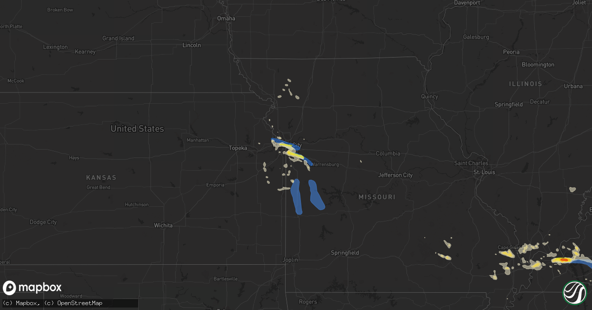
Hail Map on July 24, 2023
Get this storm
July 24 map
$229
one time, instant access
Download today. No call, no setup
Keep the $229
Bought the map and want the full workflow? Apply the entire $229 to a subscription within 7 days. None of it is wasted.
Every map, not just this one
This buys you this map. Subscription and you get every map we run, in the markets you choose from a few cities to whole states to nationwide. Plus real-time alerts the moment a storm fires.
Contact data
Name, contact info, occupancy, even credit band for addresses in the footprint. You go from where it hit to who to call.
Become the source they trust
Unlimited branding weather history reports on demand. You already have the documented answer ready for the property owner, and you are the one who showed up with it.
Property data and RoofTrace estimates
Pull up any address you have got, its value and the exact code rules for that jurisdiction, straight from One Click Code. Then RoofTrace estimates the squares, pitch, and roof value, priced the way you price.
States Impacted by Hail Map on July 24, 2023
Storm reports
Indiana
| Date | Description |
|---|---|
| 07/24/20235:06 PM CDT | Delayed report via social media. Time estimated by radar. |
| 07/24/20234:53 PM CDT | Delayed report via social media. Time estimated by radar. |
| 07/24/20234:45 PM CDT | Report from mping: quarter |
| 07/24/20234:40 PM CDT | Trees down. |
| 07/24/20234:12 PM CDT | Late report of thunderstorm winds downing a tree at county roads 525 west and 200 north. Time estimated by radar. |
| 07/24/20233:50 PM CDT | Approximate location. Time estimated from radar. Eighteen inch diameter tree was blown down. |
| 07/24/20233:45 PM CDT | A local report indicates 1.00 inch wind near Aurora |
| 07/24/20233:45 PM CDT | Hail fell for about 7 minutes. |
| 07/24/20233:40 PM CDT | Report from mping: trees uprooted or snapped; roof blown off. |
| 07/24/20233:40 PM CDT | Report from mping: ping pong ball |
| 07/24/20233:37 PM CDT | A local report indicates 1.50 inch wind near 1 SSE Mccordsville |
| 07/24/20233:33 PM CDT | Approximate location. Time estimated from other hail reports in the city. Report obtained from twitter photo. |
| 07/24/20233:25 PM CDT | Large tree branch down in a residential area. Time approximated from radar. |
Massachusetts
| Date | Description |
|---|---|
| 07/24/20236:10 PM CDT | Tree and wires down on a car near elm street and route 110. |
| 07/24/20231:30 PM CDT | Tree down on pine nook road north of river road. |
Wisconsin
| Date | Description |
|---|---|
| 07/24/20233:15 PM CDT | Corn stripped from hail. |
| 07/24/20233:15 PM CDT | Many 10-12 inch diameter trees down... Corn stripped from hail. |
| 07/24/20233:00 PM CDT | Delayed report - 1 inch hail. |
| 07/24/20232:55 PM CDT | Up to golf ball sized hail and sporadic tree damage in eastern hudson. |
| 07/24/20232:47 PM CDT | Phone report. |
| 07/24/20232:46 PM CDT | Two mature... Shallow rooted... Trees down across residential street. Photos relayed on twitter. |
| 07/24/20232:46 PM CDT | Delayed report... Multiple trees and large branchees down in hudson. Time estimated from radar. |
| 07/24/20232:45 PM CDT | Sheriffs office reports roof damage/removal from thunderstorm winds around 2:45pm. |
Kansas
| Date | Description |
|---|---|
| 07/24/20237:36 AM CDT | A local report indicates 1.00 inch wind near 2 ENE Muncie |
| 07/24/20237:06 AM CDT | 10 power poles along k7 north of fairmont rd are either snapped or leaning. |
North Carolina
| Date | Description |
|---|---|
| 07/24/20235:46 PM CDT | Tree limbs and a few small trees down. Report via social media. |
Vermont
| Date | Description |
|---|---|
| 07/24/20231:25 PM CDT | Trees down on lines on jersey st. |
South Dakota
| Date | Description |
|---|---|
| 07/24/20232:32 AM CDT | A local report indicates 60 MPH wind near 19 ESE Saint Francis |
| 07/24/20232:00 AM CDT | A local report indicates 62 MPH wind near 11 SW Parmelee |
| 07/24/20231:38 AM CDT | Very strong winds... 2 inch branches down |
| 07/24/202312:32 AM CDT | A local report indicates 62 MPH wind near 1 N Buffalo |
| 07/23/202311:50 PM CDT | A local report indicates 60 MPH wind near Oglala |
| 07/23/202311:50 PM CDT | A local report indicates 1.00 inch wind near 1 NNW Sheridan Lake |
| 07/23/202311:40 PM CDT | A local report indicates 1.00 inch wind near 1 NNW Sheridan Lake |
| 07/23/202311:29 PM CDT | A local report indicates 63 MPH wind near 12 E Oelrichs |
| 07/23/202311:06 PM CDT | A local report indicates 60 MPH wind near Hot Springs |
| 07/23/202311:06 PM CDT | A local report indicates 1.00 inch wind near Hot Springs |
| 07/23/202310:56 PM CDT | A local report indicates 60 MPH wind near 11 W Hot Springs |
| 07/23/202310:55 PM CDT | A local report indicates 74 MPH wind near 7 W Ardmore |
| 07/23/202310:50 PM CDT | A local report indicates 61 MPH wind near 7 W Ardmore |
| 07/23/202310:23 PM CDT | A local report indicates 62 MPH wind near 10 W Edgemont |
Idaho
| Date | Description |
|---|---|
| 07/23/202310:45 PM CDT | Mesonet station wyni1 dale bitner. |
| 07/23/20239:30 PM CDT | Measured by itdc6 near treasureton summit. |
| 07/23/20239:25 PM CDT | Power outages. |
| 07/23/20239:15 PM CDT | Measured by itd11 at topaz. |
West Virginia
| Date | Description |
|---|---|
| 07/24/20233:25 PM CDT | Multiple trees down in downtown huntington. |
| 07/24/20231:57 PM CDT | Six trees were reported down in various locations of south central jefferson county |
| 07/23/202310:43 PM CDT | A local storm chaser from the parkersburg area sent a picture via social media of a large tree down blocking both lanes of homewood road in lubeck. The chaser also advi |
| 07/23/202310:43 PM CDT | Trained spotter in lubeck reported large trees down in the area. Power lines and power poles down. Trash cans... Lawn furniture... Etc. Has been blown into neighboring |
| 07/23/202310:43 PM CDT | One of our broadcast media partners sent us a video of large limbs that fell at a local golf course due to thunderstorm wind gusts. Time estimated by radar. |
| 07/23/202310:40 PM CDT | Roof peeled off of barn... Tin roof torn off of chicken coop... And several young trees downed from straight line winds. |
| 07/23/20237:18 PM CDT | Tree down on the 1100 block of circle drive |
| 07/23/20237:18 PM CDT | Powerline pole down on the 400 block of eagle school road |
Michigan
| Date | Description |
|---|---|
| 07/24/20232:21 PM CDT | Delayed reported. Several trees down with power outages near moddersville. Time estimated via radar. |
Kentucky
| Date | Description |
|---|---|
| 07/24/20236:45 PM CDT | Trees down. About 600 customers without power. |
| 07/24/20236:42 PM CDT | Trees down. |
| 07/24/20236:14 PM CDT | A few trees down along mary ingles highway. Time estimated from radar. |
| 07/24/20235:45 PM CDT | Delayed report. Trees down along brownsville road. Time estimated by radar. |
| 07/24/20235:37 PM CDT | Delayed report. Trees down along sanders road. Time estimated by radar. |
| 07/24/20235:29 PM CDT | Tree down. |
| 07/24/20235:18 PM CDT | Delayed report. Several trees down throughout the county. Time estimated by radar. |
| 07/24/20234:42 PM CDT | Tree downed along winding way. Time estimated by radar. |
| 07/24/20234:39 PM CDT | Two trees down. |
| 07/24/20234:26 PM CDT | Tree down. |
| 07/24/20234:14 PM CDT | Trees down over hwy 903 in caldwell county. |
| 07/24/20234:05 PM CDT | Wind gust recorded by ky mesonet station near princeton ky. |
| 07/24/20233:55 PM CDT | Multiple reports of trees down in princeton. |
| 07/24/20233:40 PM CDT | Tree down 3 mi ne of grand rivers over highway 62. |
| 07/24/20233:27 PM CDT | Quarter to golfball sized hail reported by public in smithland kentucky. |
| 07/24/20233:20 PM CDT | Trees down in fredonia. |
| 07/24/20233:18 PM CDT | Trained spotter report of 1.5 inch hail. |
| 07/24/20233:18 PM CDT | Trained spotter reported 60 mph wind gust. |
| 07/24/20233:10 PM CDT | Power lines down and trees down in symsonia area. |
| 07/24/20233:05 PM CDT | Report by off-duty nws employee. Large tree limbs down in neighborhood near noble park area. Measured 1.88 inches of rain within about 1 hour. |
| 07/24/20232:35 PM CDT | One tree down and several limbs near mccracken-ballard border. Approximately 5 miles west-southwest of nws office. |
| 07/23/20237:42 PM CDT | A tree was blown down a few miles north of preston on kendall springs road. |
| 07/23/20237:30 PM CDT | Downed tree blocking rooster run road. |
Pennsylvania
| Date | Description |
|---|---|
| 07/24/20232:30 PM CDT | A local report indicates 1.00 inch wind near 1 WSW Mcewensville |
| 07/24/202312:40 PM CDT | Trees and wires down around williamsport. |
| 07/24/202310:24 AM CDT | Multiple trees and wires down route 171 and hausbrook heights road. Time estimated from radar. |
| 07/24/202310:15 AM CDT | Multiple trees down grand street. Time estimated from radar. |
| 07/24/202310:02 AM CDT | Trees and wires down route 1039. Time estimated from radar. |
| 07/24/202310:02 AM CDT | Multiple trees down route 492. Time estimated from radar. |
| 07/24/202310:02 AM CDT | Multiple trees and wires down route 547 and route 492. Time estimated from radar. |
| 07/24/202312:45 AM CDT | Tree down on the road. |
| 07/24/202312:42 AM CDT | 2 ft diameter tree down blocking the road. |
| 07/24/202312:30 AM CDT | Significant damage to large tent at farm show complex. Tent blew onto nearby cars. Some trees uprooted. |
| 07/23/20239:43 PM CDT | Trees and wires down. Time estimated from radar. |
| 07/23/20239:28 PM CDT | Tree down blocking the road. Time estimated from radar. |
| 07/23/20239:04 PM CDT | Tree down blocking the road. Time estimated from radar. |
| 07/23/20238:20 PM CDT | Tree/wires down. |
Missouri
| Date | Description |
|---|---|
| 07/24/20232:13 PM CDT | Grain silo and metal building blown across highway. |
| 07/24/20231:34 PM CDT | Asos station kcgi cape girardeau mo. |
| 07/24/20239:52 AM CDT | Parts city auto... |
| 07/24/20239:25 AM CDT | 60 -70 mph wind estimated. |
| 07/24/20239:22 AM CDT | A local report indicates 60 MPH wind near Archie |
| 07/24/20238:29 AM CDT | Delayed report. Large tree limb down. Time estimated from radar. |
| 07/24/20238:24 AM CDT | Delayed report. Large tree snapped. |
| 07/24/20238:14 AM CDT | Winds estimated between 60 and 70 mph. |
| 07/24/20238:14 AM CDT | A local report indicates 1.00 inch wind near 3 E Lee's Summit |
| 07/24/20238:14 AM CDT | Via mping. |
| 07/24/20237:55 AM CDT | Large tree limbs down... Power knocked out. |
| 07/24/20237:45 AM CDT | Spotter report of pea sized hail accompanying the wind. |
| 07/24/20237:39 AM CDT | Public estimating 70 mph winds in downtown kc. Reported via social media. |
Montana
| Date | Description |
|---|---|
| 07/24/20236:45 PM CDT | A local report indicates 59 MPH wind near 6 ENE Broadview |
| 07/23/20237:21 PM CDT | A local report indicates 62 MPH wind near 6 S Lockwood |
New York
| Date | Description |
|---|---|
| 07/24/20236:35 PM CDT | Tree down on brooks road. Time estimated from radar. |
| 07/24/20235:53 PM CDT | Corrects previous tstm wnd dmg report from 1 wnw west candor. Tree down blocking the road. Time estimated from radar. |
| 07/24/20235:16 PM CDT | Tree downed onto the niagara scenic parkway by pletcher road. |
| 07/24/20235:03 PM CDT | Wire on roadway. |
| 07/24/20235:02 PM CDT | Tree on a house. |
| 07/24/20234:45 PM CDT | Tree down in the town of harrisville. |
| 07/24/20234:45 PM CDT | Tree down on sally piper road. Time estimated from radar. |
| 07/24/20234:44 PM CDT | Trees and wires down near the corner of bundy rd and trumansburg rd. |
| 07/24/20234:42 PM CDT | Tree down on a house on north aurora st. |
| 07/24/20234:42 PM CDT | Tree down on twist run road. Time estimated from radar. |
| 07/24/20234:40 PM CDT | A thunderstorm that moved through tompkins county on the evening of monday... July 24th has been determined to have produced a microburst that destroyed two barns... Up |
| 07/24/20234:31 PM CDT | Barns collapsed with a lot debris... Numerous trees down. Hayts road and sheffield road in enfield. Time estimated from radar. |
| 07/24/20234:20 PM CDT | Multiple trees and wires down in smithfield. Time estimated from radar. |
| 07/24/20234:15 PM CDT | Tree downed onto power lines in the town of wilna. |
| 07/24/20233:51 PM CDT | Trees and wires down. Time estimated from radar. |
| 07/24/20232:55 PM CDT | Tree down blocking road. |
| 07/24/20232:48 PM CDT | Tree down blocking the road. Time estimated from radar. |
| 07/24/20232:38 PM CDT | Trees and wires down at duck lake road and state route 370 near victory. |
| 07/24/20232:29 PM CDT | Tree down on elm street. Time estimated from radar. |
| 07/24/20232:24 PM CDT | A local report indicates 62 MPH wind near Dannemora |
| 07/24/20232:24 PM CDT | A local report indicates 62 MPH wind near Beekmantown |
| 07/24/20232:23 PM CDT | Trees and wires down in the town of butler. |
| 07/24/20232:08 PM CDT | Trees and power lines down. |
| 07/24/20232:06 PM CDT | Trees and wires down in the town of clyde. |
| 07/24/20232:00 PM CDT | Trees and wires down. |
| 07/24/20231:54 PM CDT | Trees and wires down. |
| 07/24/20231:48 PM CDT | Trees and wires down. |
| 07/24/20231:42 PM CDT | Trees and wires down. Time estimated from radar. |
| 07/24/20231:35 PM CDT | Multiple trees uprooted and snapped. Wind estimated 55 - 72 mph. |
| 07/24/20231:35 PM CDT | Multiple trees down. |
| 07/24/20231:30 PM CDT | Tree down on lakeview road. Time estimated from radar. |
| 07/24/20231:24 PM CDT | Updates prior report. Nws survey confirms a 70 to 80 mph microburst blasted the eastern shore of cayuga lake at union springs. Numerous trees had large branches snapped |
| 07/24/20231:24 PM CDT | Multiple trees trees down on some houses. |
| 07/24/20231:10 PM CDT | 15 foot sailboat capsized at red hook dock |
| 07/24/20231:06 PM CDT | Ny 199 closed between w. Willets dr and haperman hill rd. Downed trees and wires. |
| 07/24/20231:03 PM CDT | Tree down on townline road. Time estimated from radar. |
| 07/24/202312:48 PM CDT | Tree down on wires on pierce road. Time estimated from radar. |
| 07/24/202312:38 PM CDT | Trees and wires down. Coombs road and glass factory road. Time estimated from radar. |
| 07/24/202312:35 PM CDT | Trees down. |
| 07/24/202312:35 PM CDT | Tree down across one lane of traffic at new floyd road and rickmeyer road. Time estimated from radar. |
| 07/24/202312:30 PM CDT | Wires down on ney avenue. Time estimated from radar. |
| 07/24/202312:30 PM CDT | Multiple trees and wires down. Time estimated from radar. |
| 07/24/202312:30 PM CDT | Trees and wires down in multiple locations in the village of herkimer - crossroads of gray and suiter st... Margaret st... And shells bush rd |
| 07/24/202312:30 PM CDT | Downed trees and broken limbs from thunderstorm cell that passed through. |
| 07/24/202312:15 PM CDT | Hoffman road |
| 07/24/202311:55 AM CDT | Trees and wires down at several locations from 12:55 pm to 1:00 pm. |
| 07/24/202311:02 AM CDT | Multiple trees down on state route 7 main street. |
Minnesota
| Date | Description |
|---|---|
| 07/24/20234:45 PM CDT | A local report indicates 1.25 inch wind near 7 W West Concord |
| 07/24/20234:23 PM CDT | Phone report. |
| 07/24/20233:45 PM CDT | Mostly dime hail with some quarter mixed in. Photo relayed via twitter. |
| 07/24/20233:34 PM CDT | Video relayed via social media. |
| 07/24/20233:30 PM CDT | Shredded leaves. |
| 07/24/20233:11 PM CDT | Delayed report - deputy reported golf ball size hail near hampton. Time estimated by radar. |
| 07/24/20233:03 PM CDT | Delayed report - multiple trees on powerlines in farmington. |
| 07/24/20233:02 PM CDT | Photo relayed on social media. |
| 07/24/20233:00 PM CDT | Photo relayed via social media. |
| 07/24/20233:00 PM CDT | Photo via social media. |
| 07/24/20233:00 PM CDT | 12 to 18 inch trees down... Shingles blown off rooftops. Delayed report via trained spotter... Time estimated by radar. |
| 07/24/20233:00 PM CDT | Picture of metal sign bent over. Time estimated from radar. |
| 07/24/20232:55 PM CDT | Delayed report - multiple trees on powerlines in rosemount. |
| 07/24/20232:15 PM CDT | Delayed report - multiple tress and branches down on the southern side of white bear lake. Time estimated from radar. |
Colorado
| Date | Description |
|---|---|
| 07/24/20236:56 PM CDT | Corrects previous non-tstm wnd gst report from 4 nw kersey. Awos station kgxy greeley airport. |
| 07/24/20236:56 PM CDT | A local report indicates 58 MPH wind near 4 NW Kersey |
| 07/24/20236:27 PM CDT | Also very heavy rainfall... Over an inch in the past half hour. |
| 07/24/20233:58 PM CDT | Asos station kcag craig-moffat county airport. |
| 07/23/20238:30 PM CDT | Mesonet station ew6017 bennett. |
| 07/23/20237:57 PM CDT | A local report indicates 58 MPH wind near 2 NNW Denver Intl Airpo |
| 07/23/20237:56 PM CDT | A local report indicates 68 MPH wind near 3 E Commerce City |
| 07/23/20237:56 PM CDT | A local report indicates 63 MPH wind near 3 ENE Denver Intl Airpo |
Wyoming
| Date | Description |
|---|---|
| 07/24/20233:52 PM CDT | Asos station krks rock springs airport. |
| 07/23/202311:29 PM CDT | Reports of several power lines down... Transformers blown... Some small fires... And all power out. |
| 07/23/202311:21 PM CDT | Awos station kjac jackson hole airport. |
| 07/23/202310:05 PM CDT | A local report indicates 68 MPH wind near 25 ESE Wright |
| 07/23/20239:22 PM CDT | A local report indicates 68 MPH wind near 25 ESE Wright |
Florida
| Date | Description |
|---|---|
| 07/24/20233:26 PM CDT | A large oak tree blew over at the northwest corner of u.s. Hwy 27 and fred george rd. |
Utah
| Date | Description |
|---|---|
| 07/24/20236:40 PM CDT | Approximately 12 inch diameter tree branch down. Time estimated. |
| 07/24/20236:36 PM CDT | Measured at the groome upr mesonet site. |
| 07/24/20236:30 PM CDT | Measured at the udot rwis site located on i80 at mp 40 knolls. Site id utkno. |
| 07/24/20236:20 PM CDT | Measured at the provo canyon upr mesonet site |
| 07/24/20236:20 PM CDT | Measured at the lucin upr mesonet site |
| 07/24/20236:09 PM CDT | Approx 14 inch diameter tree limb down. |
| 07/24/20235:47 PM CDT | A local report indicates 61 MPH wind near 2 N Bryce Canyon City |
| 07/24/20235:00 PM CDT | 10 inch tree branch broke off and fell onto electric wires. |
| 07/24/20234:20 PM CDT | Measured at the udot rwis site us-40 at mp 66 fruitland |
| 07/24/20233:30 PM CDT | Mesonet station utrch i-70 at richfield. |
| 07/23/20238:51 PM CDT | Measured at the slc airport faa wind sensor. |
| 07/23/20238:00 PM CDT | Measured at the hansel valley upr mesonet site. Site id pc358. |
Ohio
| Date | Description |
|---|---|
| 07/24/20236:59 PM CDT | A local report indicates 1.00 inch wind near Minerva Park |
| 07/24/20236:55 PM CDT | Report from mping: quarter |
| 07/24/20236:55 PM CDT | Report from mping: quarter |
| 07/24/20236:50 PM CDT | A local report indicates 1.50 inch wind near Minerva Park |
| 07/24/20236:45 PM CDT | Viewed from photo on social media. |
| 07/24/20236:42 PM CDT | Trees on house on both south 16th street and wilson avenue. Time estimated from radar. |
| 07/24/20236:41 PM CDT | Corrects previous tstm wnd dmg report from 3 n dublin. Large tree down on a house. |
| 07/24/20236:21 PM CDT | Sheriffs office reports multiple trees down across the county |
| 07/24/20236:18 PM CDT | A few trees were downed. |
| 07/24/20235:38 PM CDT | Large branch down. Time estimated from radar. |
| 07/24/20235:28 PM CDT | Report from mping: quarter |
| 07/24/20234:55 PM CDT | Pole down in the richwood area. |
| 07/24/20234:23 PM CDT | Report from mping: quarter |
| 07/24/20234:06 PM CDT | Report from mping: quarter |
| 07/24/20234:04 PM CDT | At lunken airport. |
| 07/24/20234:03 PM CDT | Tree down due to thunderstorm winds. Time estimated from radar. |
| 07/23/202310:20 PM CDT | Multiple trees reported down in the pomeroy and salisbury township area. Time estimated from radar. |
| 07/23/20239:59 PM CDT | Report of tree down along state route 265 east of lore city. Time estimated based on radar. |
| 07/23/20239:20 PM CDT | Tree reported down near state route 93. |
| 07/23/20239:15 PM CDT | Multiple reports of trees and lines down in crooksville. |
| 07/23/20239:15 PM CDT | Tree reported down on buzzards glory road. |
| 07/23/20239:10 PM CDT | A tree was downed along state route 180. Time estimated from radar. |
| 07/23/20239:05 PM CDT | Tree and power line reported down. |
| 07/23/20238:55 PM CDT | A tree was downed near the intersection of stage and dupler roads. Time estimated from radar. |
| 07/23/20238:13 PM CDT | Numerous trees downed in the lancaster area. |
| 07/23/20238:01 PM CDT | Tree downed on top of a home... Causing roof damage to the home. Time of event estimated from radar. |
| 07/23/20237:49 PM CDT | A local report indicates 1.00 inch wind near 2 SSE Reynoldsburg |
| 07/23/20237:48 PM CDT | A local report indicates 1.00 inch wind near 1 SSE Reynoldsburg |
| 07/23/20237:15 PM CDT | Large tree down on a house. |
Arizona
| Date | Description |
|---|---|
| 07/24/20235:40 PM CDT | Several power poles down causing outages... Minor roof damage to many structures in the area. |
Cities Impacted by Hail Map on July 24, 2023
- Leavenworth, KS
- Basehor, KS
- Kansas City, KS
- Kansas City, MO
- Riverside, MO
- Independence, MO
- Lees Summit, MO
- Greenwood, MO
- Lone Jack, MO
- Grain Valley, MO
- Pleasant Hill, MO
- Blue Springs, MO
- Kingsville, MO
- Holden, MO
- Creighton, MO
- Butler, MO
- Urich, MO
- Montrose, MO
- Clinton, MO
- Archie, MO
- Adrian, MO
- Rich Hill, MO
- Appleton City, MO
- Richards, MO
- Walker, MO
- Schell City, MO
- Osceola, MO
- Rockville, MO
- Nevada, MO
- Lowry City, MO
- Deepwater, MO
- El Dorado Springs, MO
- Montrose, PA
- New Milford, PA
- Hallstead, PA
- Susquehanna, PA
- Harford, PA
- South Gibson, PA
- Kingsley, PA
- Jackson, PA
- Thompson, PA
- Windsor, NY
- Montgomery, PA
- Williamsport, PA
- Muncy, PA
- Schroon Lake, NY
- Ellington, MO
- Redford, MO
- McLouth, KS
- Lawrence, KS
- Winona, MO
- King City, MO
- Guilford, MO
- Maysville, MO
- Wyalusing, PA
- Lawton, PA
- Laceyville, PA
- Lenexa, KS
- La Cygne, KS
- Amsterdam, MO
- Van Buren, MO
- Lynchburg, OH
- Mount Orab, OH
- Fayetteville, OH
- New Albany, PA
- Monroeton, PA
- Rome, NY
- Freeman, MO
- Cleveland, MO
- Medina, NY
- Lyndonville, NY
- Eudora, KS
- Wellsville, KS
- Edgerton, KS
- Amity, MO
- Lane, KS
- Osawatomie, KS
- Bucyrus, KS
- Stilwell, KS
- Belton, MO
- Black, MO
- Centerville, MO
- Lesterville, MO
- Garden City, MO
- Strasburg, MO
- Paola, KS
- Louisburg, KS
- Drexel, MO
- Sibley, MO
- Stanberry, MO
- Chittenango, NY
- Canastota, NY
- Union Star, MO
- Rea, MO
- Waynesville, OH
- Springboro, OH
- Dayton, OH
- Miamisburg, OH
- Rushville, MO
- Weston, MO
- Peculiar, MO
- Bonner Springs, KS
- Towanda, PA
- Savannah, MO
- Grandview, MO
- Leawood, KS
- Waldron, MO
- Overland Park, KS
- Shawnee, KS
- Prairie Village, KS
- Raymore, MO
- Dover, KY
- Bunceton, MO
- Pilot Grove, MO
- Hooper, NE
- Muskegon, MI
- Sherrill, IA
- Monticello, WI
- Jesup, IA
- Ravenna, MI
- Irwin, IA
- Copenhagen, NY
- Henderson, NY
- Ogden, IA
- Logan, IA
- Belmont, WI
- Saginaw, MI
- Hazard, NE
- Belleville, WI
- Earlville, IA
- North Bend, NE
- Schuyler, NE
- Templeton, IA
- Sandusky, MI
- Manchester, IA
- Evansville, WI
- Dousman, WI
- Independence, IA
- Dyersville, IA
- Potosi, WI
- Woodbine, IA
- Alma, MI
- Columbus, NE
- Lowville, NY
- Castorland, NY
- Edgerton, WI
- Caro, MI
- Casnovia, MI
- Blair, NE
- Milwaukee, WI
- Beaman, IA
- Saint Louis, MI
- Union, IA
- Cedar Springs, MI
- Deckerville, MI
- Henderson Harbor, NY
- Stanton, MI
- Winthrop, IA
- Wheeler, MI
- Rockville, NE
- Mukwonago, WI
- Blanchardville, WI
- Kent City, MI
- Boone, IA
- Scranton, IA
- Crested Butte, CO
- Reese, MI
- Lindon, CO
- Decker, MI
- Adams, NY
- Silver Creek, NE
- Breckenridge, MI
- Snover, MI
- Darlington, WI
- Fort Atkinson, WI
- Zearing, IA
- New Glarus, WI
- Ames, IA
- Jefferson, IA
- Story City, IA
- Riverdale, MI
- Grand Junction, IA
- Waukesha, WI
- Argyle, WI
- Dannebrog, NE
- Hemlock, MI
- Vestaburg, MI
- Holy Cross, IA
- Sand Lake, MI
- Palmer, NE
- Lexington, NE
- Castle Rock, CO
- Adams Center, NY
- Waterloo, IA
- Parker, CO
- North Prairie, WI
- Rodman, NY
- Vassar, MI
- New Vienna, IA
- Hudson, IA
- New Berlin, WI
- New Providence, IA
- Deford, MI
- Ravenna, NE
- Reinbeck, IA
- Cadyville, NY
- Saranac, NY
- Morrisonville, NY
- Plattsburgh, NY
- West Chazy, NY
- Stillwater, MN
- Bayport, MN
- Hudson, WI
- Roberts, WI
- River Falls, WI
- Lakeland, MN
- Lake Elmo, MN
- Saint Paul, MN
- Inver Grove Heights, MN
- Rosemount, MN
- Hastings, MN
- Farmington, MN
- Hampton, MN
- Freeport, MN
- Albany, MN
- Avon, MN
- Mccordsville, IN
- Indianapolis, IN
- Greenfield, IN
- Aurora, IN
- Paducah, KY
- Ledbetter, KY
- Brookport, IL
- Smithland, KY
- Grand Rivers, KY
- Calvert City, KY
- Eddyville, KY
- Kuttawa, KY
- Princeton, KY
- Gilbertsville, KY
- Baldwin, WI
- Hammond, WI
- Woodville, WI
- Cannon Falls, MN
- Randolph, MN
- Dennison, MN
- Nerstrand, MN
- Kenyon, MN
- Northfield, MN
- Saint Cloud, MN
- Sauk Rapids, MN
- Clear Lake, MN
- Clearwater, MN
- Maple Lake, MN
- Annandale, MN
- Saint Joseph, MN
- Cold Spring, MN
- Richmond, MN
- Watkins, MN
- Dayton, KY
- Newport, KY
- Cincinnati, OH
- Fort Thomas, KY
- Bellevue, KY
- Petersburg, KY
- Burlington, KY
- Rising Sun, IN
- Muncie, IN
- Cerulean, KY
- Cadiz, KY
- Gracey, KY
- Andover, MN
- Minneapolis, MN
- West Concord, MN
- Claremont, MN
- Columbus, OH
- Westerville, OH
- New Albany, OH
- Boonville, IN
- Fountaintown, IN
- Richwood, OH
- Wickliffe, KY
- Saint Regis Falls, NY
- Oriskany, NY
- Westmoreland, NY
- Shelbyville, KY
- Springport, IN
- Middletown, IN
- Daleville, IN
- Selma, IN
- Moriah, NY
- Witherbee, NY
- Moriah Center, NY
- Port Henry, NY
- Mineville, NY
- Cheyenne, WY
- Otisco, IN
- Underwood, IN
- Marysville, IN
- Scottsburg, IN
- Henryville, IN
- Jasper, IN
- Eckerty, IN
- Carthage, NY
- Tamms, IL
- Hartsville, IN
- Hope, IN
- Bethel, OH
- Sardinia, OH
- Syracuse, NY
- Nedrow, NY
- La Fayette, NY
- Jamesville, NY
- Danville, PA
- Watsontown, PA
- Milton, PA
- New Columbia, PA
- Leitchfield, KY
- McDaniels, KY
- Marion, KY
- Grey Eagle, MN
- Burtrum, MN
- Ozark, IL
- Paradox, NY
- Olmstedville, NY
- Coldwater, OH
- Celina, OH
- Westport, IN
- South Haven, MN
- Rushville, IN
- Hartford, KY
- Horse Branch, KY
- Olaton, KY
- Beaver Dam, KY
- Fordsville, KY
- Hillsboro, OH
- Buffalo, MN
- Greensburg, IN
- West Point, KY
- Louisville, KY
- Elizabeth, IN
- North Hudson, NY
- Pueblo, CO
- Chaffee, MO
- Fredonia, KY
- Anoka, MN
- Crown Point, NY
- Ticonderoga, NY
- California, KY
- Butler, KY
- De Mossville, KY
- Moscow, OH
- Calhoun, KY
- Moravia, NY
- Madisonville, KY
- Manitou, KY
- Germantown, KY
- Maysville, KY
- Tennyson, IN
- Lynnville, IN
- Nebo, KY
- Bedford, KY
- Westport, KY
- Salem, KY
- Crofton, KY
- Fishers, IN
- Fortville, IN
- Hawesville, KY
- Allenwood, PA
- Williamsburg, OH
- Blanchester, OH
- Cypress, IL
- Felicity, OH
- Foster, KY
- Dexter, MO
- Covington, KY
- Ft Mitchell, KY
- Rumsey, KY
- West Paducah, KY
- Metropolis, IL
- Seymour, IN
- North Vernon, IN
- Moores Hill, IN
- Ullin, IL
- Brooksville, KY
- Brownstown, IN
- Crothersville, IN
- Glenwood, WV
- Ashton, WV
- Charleston, MO
- Columbus, IN
- Huntingdon, TN
- McKenzie, TN
- Henry, TN
- Lorraine, NY
- Van Etten, NY
- Tiline, KY
- Advance, MO
- Oran, MO
- Sikeston, MO
- Matthews, MO
- Vanduser, MO
- Bell City, MO
- Lowman, NY
- Erin, NY
- Spencer, NY
- La Center, KY
- Bardwell, KY
- Cairo, IL
- Cunningham, KY
- Barlow, KY
- Latonia, KY
- Independence, KY
- Melbourne, KY
- Morning View, KY
- Alexandria, KY
- New Richmond, OH
- Grandview, IN
- Lewisport, KY
- Nabb, IN
- Lexington, IN
- Philpot, KY
- Lamar, IN
- Evanston, IN
- Clinton, AR
- Riverton, WY
- Scott City, MO
- Benton, MO
- Austin, IN
- Huntingburg, IN
- Golconda, IL
- Houston, OH
- Russia, OH
- Grantsburg, IL
- Vienna, IL
- Lander, WY
- White Plains, KY
- Earlington, KY
- Mortons Gap, KY
- Milltown, IN
- Kevil, KY
- Melber, KY
- Cape Girardeau, MO
- Whitewater, MO
- Miller City, IL
- Brooks, KY
- Dale, IN
- Holland, IN
- Sebree, KY
- Sacramento, KY
- Island, KY
- Erlanger, KY
- Florence, KY
- Hampton, KY
- Golden Gate, IL
- Ellery, IL
- Fairfield, IL
- Deputy, IN
- Elizabethtown, KY
- Glendale, KY
- Cecilia, KY
- Magnolia, KY
- Canmer, KY
- Scotland, AR
- Arapahoe, WY
- Marble Hill, MO
- Ferdinand, IN
- Charlestown, IN
- Goshen, KY
- Robards, KY
- Henderson, KY
- Morgantown, KY
- Bloomfield, MO
- Dudley, MO
- Altamont, NY
- Berne, NY
- Gentryville, IN
- Chrisney, IN
- Dongola, IL
- Pulaski, IL
- Thebes, IL
- Jonesboro, IL
- Karnak, IL
- Lewisburg, PA
- Elizabethtown, IN
- La Grange, KY
- Ghent, KY
- Sanders, KY
- Warsaw, KY
- Drakesboro, KY
- Dawson Springs, KY
- Burna, KY
- Caneyville, KY
- Celestine, IN
- Douglas, WY
- Gillette, WY
- Newcastle, WY
- Lance Creek, WY
- Lusk, WY
- Hot Springs, SD
- Harrison, NE
- Oral, SD
- Custer, SD
- Buffalo Gap, SD
- Edgemont, SD
- Crawford, NE
- Aurora, CO
- Denver, CO
- Commerce City, CO
- Watkins, CO
- Bennett, CO
- Hudson, CO
- Brighton, CO
- Pine Ridge, SD
- Oelrichs, SD
- Chadron, NE
- Whitney, NE
- Smithwick, SD
- Crookston, NE
- Batesland, SD
- Kilgore, NE
- Saint Francis, SD
- Tuthill, SD
- Porcupine, SD
- Manderson, SD
- Valentine, NE
- Allen, SD
- Cody, NE
- Oglala, SD
- Martin, SD
- Wounded Knee, SD
- Hay Springs, NE
- Urbana, OH
- English, IN
- Glendo, WY
- Richmond, MI
- Dennison, OH
- Twining, MI
- Conover, OH
- Fletcher, OH
- Augusta, KY
- Grayson, KY
- Medway, OH
- New Carlisle, OH
- Fairborn, OH
- Brackney, PA
- Salem, IN
- Birnamwood, WI
- Wausau, WI
- Aniwa, WI
- Glenwood, IN
- Fort Loramie, OH
- McClure, PA
- Richfield, PA
- McAlisterville, PA
- Beaver Springs, PA
- Ogilvie, MN
- Braham, MN
- Mora, MN
- Ithaca, NY
- Owensboro, KY
- Dundee, KY
- Natural Bridge, NY
- New Washington, IN
- Hodgenville, KY
- Springfield, OH
- Cable, OH
- Springfield, KY
- Vallonia, IN
- Medora, IN
- Lebanon, TN
- Gallatin, TN
- Belleville, WV
- Ravenswood, WV
- Crestwood, KY
- South Charleston, OH
- London, OH
- South Solon, OH
- Fresno, OH
- Coshocton, OH
- Saint Meinrad, IN
- Lancaster, OH
- Pickerington, OH
- Baltimore, OH
- Carroll, OH
- Hockley, TX
- Chemung, NY
- Lockwood, NY
- Elizabeth, WV
- Macfarlan, WV
- Munfordville, KY
- Owingsville, KY
- Hillsboro, KY
- Ewing, KY
- Moorefield, KY
- Carlisle, KY
- Flemingsburg, KY
- Sharpsburg, KY
- Shelbyville, IN
- Chapmansboro, TN
- Ashland City, TN
- Charlotte, TN
- Pendleton, KY
- Bethlehem, IN
- Saint Paris, OH
- Bloomsburg, PA
- Falmouth, KY
- Millersport, OH
- Pataskala, OH
- Reynoldsburg, OH
- Etna, OH
- Gravel Switch, KY
- Eminence, MO
- Rapid City, SD
- Parkersburg, WV
- Bloomfield, IN
- Mount Washington, KY
- Shepherdsville, KY
- Newark Valley, NY
- Goodlettsville, TN
- Mayslick, KY
- Georgetown, OH
- Mount Olivet, KY
- Antigo, WI
- Deerbrook, WI
- White Deer, PA
- Laconia, IN
- Cypress, TX
- Marengo, OH
- Prospect, KY
- Saint Anthony, IN
- Taylorsville, KY
- Bloomfield, KY
- Fairfield, KY
- Coxs Creek, KY
- Jupiter, FL
- Quaker City, OH
- Cambridge, OH
- Old Washington, OH
- Lore City, OH
- Salesville, OH
- Senecaville, OH
- Sellersburg, IN
- Memphis, IN
- Delaware, OH
- Ostrander, OH
- Finchville, KY
- Maceo, KY
- Bardstown, KY
- Mechanicsburg, OH
- Mifflin, PA
- McEwensville, PA
- Turbotville, PA
- Frankfort, KY
- Lawrenceburg, KY
- Waddy, KY
- Lexington, KY
- Midway, KY
- Georgetown, KY
- Versailles, KY
- Lewis Center, OH
- Powell, OH
- Dubois, IN
- Rockport, IN
- Mackville, KY
- Willisburg, KY
- Jersey Shore, PA
- Millersburg, OH
- Simpsonville, KY
- Fisherville, KY
- Galena, OH
- Rockport, WV
- Mineral Wells, WV
- Washington, WV
- Millville, PA
- Cromwell, KY
- Saint Charles, KY
- Quincy, IN
- Cloverdale, IN
- Hickory, KY
- Benton, KY
- Reynolds Station, KY
- Grand Chain, IL
- Tollesboro, KY
- West Liberty, OH
- Dry Ridge, KY
- Williamstown, KY
- Muldraugh, KY
- Alpena, MI
- Plain City, OH
- Dublin, OH
- West Palm Beach, FL
- Lock Haven, PA
- Big Clifty, KY
- Breesport, NY
- Symsonia, KY
- Union Dale, PA
- South Vienna, OH
- Marysville, OH
- Oakland City, IN
- Stamping Ground, KY
- Friendsville, PA
- Sunbury, OH
- Ringle, WI
- Irvington, KY
- Crittenden, KY
- Canal Winchester, OH
- Pleasantville, OH
- French Lick, IN
- Manchester, OH
- Aberdeen, OH
- Ripley, OH
- Endicott, NY
- Blacklick, OH
- Hill City, SD
- Garrison, KY
- Joelton, TN
- Whites Creek, TN
- Fairdale, KY
- Lebanon Junction, KY
- Warsaw, OH
- Walhonding, OH
- Glencoe, KY
- Sparta, KY
- Verona, KY
- Hardinsburg, IN
- Palestine, WV
- Borden, IN
- Pekin, IN
- Waverly, TN
- McEwen, TN
- Hilliard, OH
- West Union, OH
- Greenup, KY
- Merriman, NE
- Marsland, NE
- Wood Lake, NE
- Pleasant City, OH
- Gordon, NE
- Kipling, OH
- Whitman, NE
- Mifflintown, PA
- Port Royal, PA
- Fife Lake, MI
- Torrington, WY
- Scipio, IN
- Newport, PA
- Liverpool, PA
- Millerstown, PA
- Whitesville, KY
- Roseville, OH
- Starrucca, PA
- Hardyville, KY
- New Haven, KY
- Loretto, KY
- Rushville, NE
- Harrodsburg, KY
- Ajo, AZ
- Coolville, OH
- Santa Claus, IN
- Garfield, KY
- Sadieville, KY
- Orangeville, PA
- Halifax, PA
- Clarksville, IN
- Jeffersonville, IN
- Paoli, IN
- Mount Eden, KY
- Pewee Valley, KY
- Belknap, IL
- Taswell, IN
- Thedford, NE
- Brewster, NE
- Johnstown, NE
- Afton, MN
- Ainsworth, NE
- Lancaster, MN