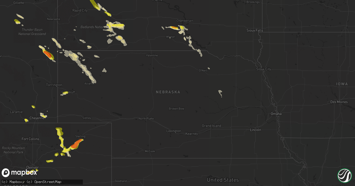
Hail Map in Nebraska on July 24, 2018
Get this storm
July 24 map
$229
one time, instant access
Download today. No call, no setup
Keep the $229
Bought the map and want the full workflow? Apply the entire $229 to a subscription within 7 days. None of it is wasted.
Every map, not just this one
This buys you this map. Subscription and you get every map we run, in the markets you choose from a few cities to whole states to nationwide. Plus real-time alerts the moment a storm fires.
Contact data
Name, contact info, occupancy, even credit band for addresses in the footprint. You go from where it hit to who to call.
Become the source they trust
Unlimited branding weather history reports on demand. You already have the documented answer ready for the property owner, and you are the one who showed up with it.
Property data and RoofTrace estimates
Pull up any address you have got, its value and the exact code rules for that jurisdiction, straight from One Click Code. Then RoofTrace estimates the squares, pitch, and roof value, priced the way you price.
Storm reports in Nebraska
Nebraska
| Date | Description |
|---|---|
| 07/24/20184:40 AM CDT | Some tree damage reported with wind gusts estimated around 60 mph. |
| 07/24/20181:17 AM CDT | At 617 PM MDT, a severe thunderstorm was located over Scotts Bluff National Monument, or near Scottsbluff, moving east at 30 mph. HAZARD...60 mph wind gusts and half dollar size hail. SOURCE...Radar indicated. IMPACT...Hail damage to vehicles is expected. Expect wind damage to roofs, siding, and trees. Locations impacted include... Scottsbluff, Gering, Bayard, Terrytown, Minatare, Lake Minatare Campground, Scotts Bluff National Monument, Hubbard Hill, Moomaws Corner, Scottsbluff Airport, Lake Minatare, Melbeta and McGrew. |
| 07/24/20181:10 AM CDT | No damage reported...however the whole house shook. |
| 07/23/20187:38 PM CDT | Hail was falling for three minutes. |
All States Impacted by Hail Map on July 24, 2018
Cities Impacted by Hail Map on July 24, 2018
- Pleasanton, TX
- Richardton, ND
- Hebron, ND
- Aurora, CO
- Medina, ND
- Tappen, ND
- Cleveland, ND
- Jamestown, ND
- Escalante, UT
- Alma, GA
- Mershon, GA
- Hurdsfield, ND
- Pettibone, ND
- Robinson, ND
- Chaseley, ND
- Bowdon, ND
- Glen Ullin, ND
- Almont, ND
- Hamill, SD
- Gregory, SD
- Ideal, SD
- Hillsdale, WY
- Cheyenne, WY
- Burns, WY
- Stanton, ND
- New Salem, ND
- Beulah, ND
- Hazen, ND
- Porcupine, SD
- Martin, SD
- Batesland, SD
- Allen, SD
- Santa Rosa, NM
- Lusk, WY
- Pingree, ND
- Woodworth, ND
- Buchanan, ND
- Littleton, CO
- Englewood, CO
- Baxley, GA
- Mitchell, NE
- Scottsbluff, NE
- Gering, NE
- La Loma, NM
- Hemingford, NE
- Marsland, NE
- Buffalo Creek, CO
- Sturgis, SD
- New Underwood, SD
- Gardner, CO
- La Veta, CO
- Flasher, ND
- Belle Fourche, SD
- Gillette, WY
- Wright, WY
- Strasburg, CO
- Burke, SD
- Herrick, SD
- Saint Charles, SD
- Cimarron, NM
- Center, ND
- Stanley, NM
- Fort Morgan, CO
- Brush, CO
- Kyle, SD
- Tuthill, SD
- Wanblee, SD
- Aguilar, CO
- Ocate, NM
- Chadron, NE
- Carson, ND
- New Leipzig, ND
- Quinn, SD
- Wall, SD
- Yerington, NV
- Fairfax, SD
- Butte, NE
- Wasta, SD
- Buford, WY
- Granite Canon, WY
- Cotulla, TX
- Westcliffe, CO
- Mcclusky, ND
- Butte, ND
- Florissant, CO
- Winner, SD
- Interior, SD
- Kadoka, SD
- Taylor, ND
- New Raymer, CO
- Weldona, CO
- Wetmore, CO
- Lance Creek, WY
- Hillrose, CO
- Weston, CO
- Clark, SD
- Bingham, NE
- Patagonia, AZ
- Whitney, NE
- Crawford, NE
- Harrison, NE
- Atwood, CO
- Shelby, MT
- Edgemont, SD
- Bennett, CO
- Log Lane Village, CO
- Sterling, CO
- Merino, CO
- Akron, CO
- Lake George, CO
- Ellsworth, NE
- Elbert, CO
- Peyton, CO
- Spearfish, SD
- Owanka, SD
- Alliance, NE
- Grover, CO
- Guadalupita, NM
- Woodland Park, CO
- Colorado Springs, CO
- Strasburg, ND
- Spencer, NE
- Cubero, NM
- Elgin, ND
- Wiggins, CO
- Charlotte, TX
- Smithwick, SD
- Ruso, ND
- Pine Ridge, SD
- Story, WY
- Hot Springs, SD
- Oral, SD
- Wellington, NV
- Smith, NV
- Hay Springs, NE
- Ashby, NE
- Scenic, SD
- Runge, TX
- Drake, ND
- Vale, SD
- Newell, SD
- Lyman, NE
- Briggsdale, CO
- Scott City, KS
- Lamoure, ND
- Ribera, NM
- Mcgregor, MN
- Whitewood, SD
- Bonesteel, SD
- Antonito, CO
- Crosby, MN
- Merrifield, MN
- Fairburn, SD
- Buffalo Gap, SD
- Verona, ND
- San Jose, NM
- Statesboro, GA
- Cut Bank, MT
- Denver, CO
- Snyder, CO
- Albion, NE
- Raymond, SD
- Chamberlain, SD
- Platte, SD
- Rociada, NM
- Sapello, NM
- Rainsville, NM
- Mora, NM
- Buena Vista, NM
- Woodrow, CO
- Walsenburg, CO
- Rushville, NE
- Fowlerton, TX
- Dawson, ND
- Page, NE
- Oneill, NE
- Zap, ND
- Tilden, TX
- Kenedy, TX
- Petersburg, NE
- Tijeras, NM
- Gladstone, ND
- Monument, CO
- Divide, CO
- Morrison, CO


