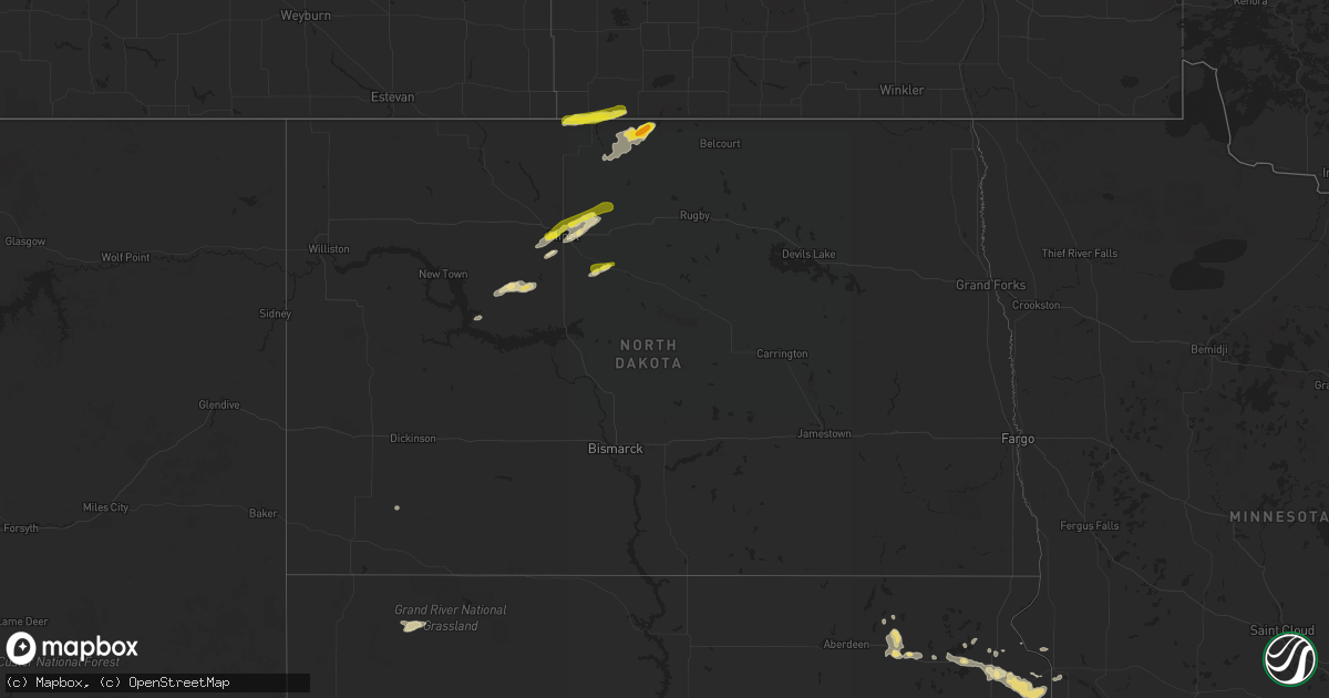
Hail Map in North Dakota on July 24, 2017
Get this storm
July 24 map
$229
one time, instant access
Download today. No call, no setup
Keep the $229
Bought the map and want the full workflow? Apply the entire $229 to a subscription within 7 days. None of it is wasted.
Every map, not just this one
This buys you this map. Subscription and you get every map we run, in the markets you choose from a few cities to whole states to nationwide. Plus real-time alerts the moment a storm fires.
Contact data
Name, contact info, occupancy, even credit band for addresses in the footprint. You go from where it hit to who to call.
Become the source they trust
Unlimited branding weather history reports on demand. You already have the documented answer ready for the property owner, and you are the one who showed up with it.
Property data and RoofTrace estimates
Pull up any address you have got, its value and the exact code rules for that jurisdiction, straight from One Click Code. Then RoofTrace estimates the squares, pitch, and roof value, priced the way you price.
Storm reports in North Dakota
North Dakota
| Date | Description |
|---|---|
| 07/23/201711:53 PM CDT | A local report indicates 1.50 inch wind near 2 NNW CARBURY |
| 07/23/201710:48 PM CDT | A local report indicates 1.00 inch wind near MINOT |
| 07/23/201710:36 PM CDT | A local report indicates 1.25 inch wind near 1 NNW MINOT |
| 07/23/20178:59 PM CDT | Hail lasted from 850 pm to around 859 pm. Hail is covering the yard but melting fast. Sizes ranged from dimes to quarters. |
All States Impacted by Hail Map on July 24, 2017
Cities Impacted by Hail Map on July 24, 2017
- Burnet, TX
- Winner, SD
- Twin Brooks, SD
- Bassett, NE
- Groton, SD
- Andover, SD
- Velva, ND
- Marvin, SD
- Summit, SD
- South Shore, SD
- Kempton, PA
- New Ringgold, PA
- Mcdonough, GA
- Kennebec, SD
- Presho, SD
- Voltaire, ND
- Sawyer, ND
- Florence, AL
- Happy, TX
- Hanceville, AL
- Bremen, AL
- Valera, TX
- Talpa, TX
- Makoti, ND
- Plaza, ND
- Ryder, ND
- Milbank, SD
- Revillo, SD
- Stockholm, SD
- Labolt, SD
- Granville, ND
- Surrey, ND
- Minot, ND
- Norwich, ND
- Long Pine, NE
- Ainsworth, NE
- Mason, TX
- Stevensville, PA
- Wyalusing, PA
- Ozona, TX
- Murdo, SD
- Warwick, MD
- Claremont, SD
- Tunkhannock, PA
- Nicholson, PA
- Dalton, PA
- Factoryville, PA
- Fleetville, PA
- Antler, ND
- Westhope, ND
- Souris, ND
- Griffin, GA
- Milner, GA
- Oneonta, AL
- Cleveland, AL
- White River, SD
- Leander, TX
- Cedar Park, TX
- Crockett, TX
- Jean, NV
- Klamath Falls, OR
- Shiloh, GA
- Starkville, MS
- Wendel, CA
- Groesbeck, TX
- Amarillo, TX
- Borger, TX
- Lovelock, NV
- Irvine, KY
- Vega, TX
- New Prague, MN
- Springfield, KY
- Townsend, DE
- Northfield, MN
- Webster, MN
- Wilmot, SD
- Syracuse, NY
- East Syracuse, NY
- Ovid, CO
- Fayetteville, GA
- Michie, TN
- Locust Grove, GA
- Gaylord, MN
- Doyle, CA
- Herlong, CA
- Colome, SD
- Moulton, AL
- Fernley, NV
- Tamaqua, PA
- Middleport, PA
- New Tripoli, PA
- Fogelsville, PA
- Orwigsburg, PA
- New Philadelphia, PA
- Cumbola, PA
- Kutztown, PA
- Wadsworth, NV
- Silver Springs, NV
- Ganado, AZ
- Paducah, TX
- Bottineau, ND
- Liverpool, NY
- Sparta, GA
- Des Lacs, ND
- Burlington, ND
- Brighton, MO
- Willard, MO
- Lookout, CA
- Canby, CA
- Standish, CA
- Fayette, AL
- Harrington, DE
- Sparks, NV
- Brownton, MN
- Draper, SD
- Mission, SD
- Prairie City, SD
- Belle Plaine, MN
- Jonesboro, GA
- Hampton, GA
- Likely, CA
- Waubay, SD
- Lohn, TX
- Grant, NE
- Tuscumbia, AL
- Silverton, TX
- Newburg, ND
- Kramer, ND
- Bristol, SD
- Lodgepole, SD
- Menard, TX
- Hext, TX
- Parshall, ND
- Batesville, MS
- Federalsburg, MD
- Greenwood, DE
- Bridgeville, DE
- Roseglen, ND
- Cullman, AL
- Holly Pond, AL
- Hereford, TX
- Madeline, CA
- Worton, MD
- Paisley, OR
- Orefield, PA
- Garrison, MO
- Peachtree City, GA
- Arlington, MN
- Schnecksville, PA
- Saint Clair, PA
- Allentown, PA
- Pottsville, PA
- Lenhartsville, PA
- New England, ND
- Ortonville, MN
- Clinton, MN
- Woodland, GA
- Burfordville, MO
- Whitewater, MO
- Loris, SC
- Conway, SC
- Ortley, SD
- Webster, SD
- Jackson, MO
- Rhodesdale, MD
- Birmingham, AL
- Central City, KY
- Jordan, MN
- Seaford, DE
- Chappell, NE
- Wayside, TX
- Peever, SD
- Grenville, SD
- Strafford, MO
- Springfield, MO
- Warthen, GA
- Sandersville, GA
- Beech Creek, KY
- Beechmont, KY
- Wood, SD
- Henderson, MN
- Lonsdale, MN
- Odessa, MN
- Bellingham, MN
- Mertztown, PA
- Barto, PA
- Zionsville, PA
- Macungie, PA
- Springville, PA
- Vernon, AL
- Hector, MN
- Buffalo Lake, MN
- Waverly Hall, GA
- Madisonville, KY
- Jermyn, PA
- Rogersville, MO
- Oshkosh, NE
- Fallon, NV
- Carbondale, PA
- Fort Pierre, SD
- Okaton, SD
- Springview, NE
- Deering, ND
- Glenburn, ND
- Bantry, ND


