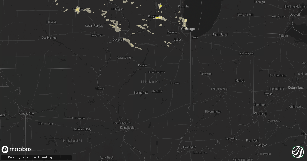
Hail Map in Illinois on July 23, 2016
Get this storm
July 23 map
$229
one time, instant access
Download today. No call, no setup
Keep the $229
Bought the map and want the full workflow? Apply the entire $229 to a subscription within 7 days. None of it is wasted.
Every map, not just this one
This buys you this map. Subscription and you get every map we run, in the markets you choose from a few cities to whole states to nationwide. Plus real-time alerts the moment a storm fires.
Contact data
Name, contact info, occupancy, even credit band for addresses in the footprint. You go from where it hit to who to call.
Become the source they trust
Unlimited branding weather history reports on demand. You already have the documented answer ready for the property owner, and you are the one who showed up with it.
Property data and RoofTrace estimates
Pull up any address you have got, its value and the exact code rules for that jurisdiction, straight from One Click Code. Then RoofTrace estimates the squares, pitch, and roof value, priced the way you price.
Storm reports in Illinois
Illinois
| Date | Description |
|---|---|
| 07/23/20166:42 PM CDT | A few large limbs downed. Radar estimated time. |
| 07/23/20166:28 PM CDT | Wind estimated at 55-60 mph. Dempster street west of skokie blvd. |
| 07/23/20166:26 PM CDT | Branches down at route 25 and sunset park. |
| 07/23/20166:15 PM CDT | Several 6 inch diameter branches down. |
| 07/23/20165:32 PM CDT | Also 55 to 60 mph winds and very heavy rainfall with visibility around 200 feet. |
| 07/23/20165:28 PM CDT | Power line down |
| 07/23/20165:15 PM CDT | Large tree blown down. Time estimated by radar. |
| 07/23/20164:58 PM CDT | Numerous large branched downed in the city. Radar estimated time. |
| 07/22/201611:30 PM CDT | Multiple large tree branches down. Some branches fell on a house. Minor damage to the house. One tree uprooted. Time estimated. Late report. |
| 07/22/201610:39 PM CDT | Couple trees downed. Numerous large branches downed. Outbuilding damaged. Radar estimated time. |
| 07/22/20169:28 PM CDT | Numerous large trees down over fences on property...several trees down or uprooted in town of geneseo...time estimated from radar. |
| 07/22/20168:08 PM CDT | Multiple power lines down in the town of dixon. Time estimated from radar. |
| 07/22/20167:58 PM CDT | Old shed knocked down... Portion of an old barn damaged... And branches downed. Radar estimated time. |
| 07/22/20167:08 PM CDT | Branches down at route 25 and sunset park. Corrected for radar estimated time. |
All States Impacted by Hail Map on July 23, 2016
Cities Impacted by Hail Map on July 23, 2016
- Osceola, WI
- Amery, WI
- Star Prairie, WI
- Atwater, MN
- New Park, PA
- Red Lion, PA
- Brogue, PA
- Airville, PA
- York, PA
- Felton, PA
- Windsor, PA
- Wrightsville, PA
- Menoken, ND
- Bismarck, ND
- Medina, ND
- Driscoll, ND
- Mandan, ND
- Baxter, MN
- Brainerd, MN
- Hanley Falls, MN
- Watertown, MN
- Mound, MN
- Maple Plain, MN
- Excelsior, MN
- Saint Bonifacius, MN
- Poland, ME
- Oxford, ME
- Casco, ME
- Fairmont, NC
- Orrum, NC
- McGrath, MN
- Isle, MN
- Starbuck, MN
- Streeter, ND
- Hartland, MN
- Elysian, MN
- Madison Lake, MN
- Waseca, MN
- Waldorf, MN
- Alden, MN
- New Richland, MN
- Janesville, MN
- Pemberton, MN
- Wells, MN
- Eagle Lake, MN
- Winthrop, IA
- Danbury, WI
- Trego, WI
- Spooner, WI
- Albert Lea, MN
- Emmons, MN
- Twin Lakes, MN
- Lewiston, MN
- Webster, WI
- Sandstone, MN
- Hinckley, MN
- Clarkfield, MN
- Wing, ND
- Regan, ND
- Dekalb, IL
- Clare, IL
- Sycamore, IL
- Calmar, IA
- Eagle Bridge, NY
- Cambridge, NY
- Lake Lillian, MN
- Nisswa, MN
- Garrison, MN
- Pillager, MN
- Pequot Lakes, MN
- Deerwood, MN
- Madison, MN
- Lake Crystal, MN
- Nicollet, MN
- Mankato, MN
- Oregon, IL
- Dixon, IL
- La Crosse, WI
- Coon Valley, WI
- Viroqua, WI
- Westby, WI
- Cashton, WI
- Chaseburg, WI
- Stoddard, WI
- Ward, AR
- Austin, AR
- Rome, NY
- Mineral Point, WI
- Darlington, WI
- Platteville, WI
- Belmont, WI
- Dolgeville, NY
- Atkinson, IL
- Darwin, MN
- Dassel, MN
- Gackle, ND
- Wells, VT
- West Pawlet, VT
- Moira, NY
- Brasher Falls, NY
- Dickinson Center, NY
- Brushton, NY
- North Lawrence, NY
- Buda, IL
- Bradford, IL
- Calhoun, GA
- Adairsville, GA
- Benson, MN
- Danvers, MN
- Kerkhoven, MN
- Murdock, MN
- Barrington, NJ
- Gloucester City, NJ
- Magnolia, NJ
- Bellmawr, NJ
- Lawnside, NJ
- Oaklyn, NJ
- Audubon, NJ
- Mount Ephraim, NJ
- Haddonfield, NJ
- Haddon Heights, NJ
- Viola, WI
- De Witt, AR
- Crocketts Bluff, AR
- Springbrook, WI
- La Junta, CO
- Colesburg, IA
- Whitesburg, KY
- Whiteville, NC
- Blountsville, AL
- Hayden, AL
- Hanceville, AL
- Hoffmeister, NY
- Ogilvie, MN
- Litchfield, MN
- West Union, IA
- Castalia, IA
- Ossian, IA
- Clermont, IA
- Postville, IA
- Luana, IA
- Elgin, IA
- Hector, AR
- Prophetstown, IL
- Stratford, NY
- Caroga Lake, NY
- Mora, MN
- Wahkon, MN
- Milaca, MN
- Camden, AR
- Chidester, AR
- Delight, AR
- Fort Atkinson, IA
- Waucoma, IA
- Morris, MN
- Decorah, IA
- Ridgeway, IA
- Hokah, MN
- La Crescent, MN
- Grove City, MN
- Coldwater, MS
- Kellogg, MN
- Wabasha, MN
- Alma, WI
- Janesville, WI
- Avalon, WI
- Delavan, WI
- Darien, WI
- Cheraw, CO
- Pine City, MN
- Argyle, NY
- Salem, NY
- Robinson, ND
- Grasston, MN
- Henriette, MN
- Evansdale, IA
- Waterloo, IA
- Cedar Falls, IA
- Hudson, IA
- Farmersburg, IA
- Saint Olaf, IA
- Miami, FL
- Leaf River, IL
- Agar, SD
- Onida, SD
- Monticello, IA
- Milan, MN
- New Boston, TX
- Alachua, FL
- Charlotte, NC
- Huntersville, NC
- Woodworth, ND
- Kensal, ND
- Courtenay, ND
- Montpelier, ND
- Ionia, IA
- New Hampton, IA
- Alta Vista, IA
- Worthington, IA
- Hopkinton, IA
- Delhi, IA
- Earlville, IA
- Marston, NC
- Rockingham, NC
- Bradford, IA
- Hampton, IA
- Hot Springs National Park, AR
- Lamar, CO
- Nashville, AR
- Rowley, IA
- Independence, IA
- Steele, ND
- Wellsburg, IA
- Morris, IL
- Manchester, IA
- Lyon Mountain, NY
- Solen, ND
- Glencoe, IL
- Winnetka, IL
- Holland, IA
- Parkersburg, IA
- Aitkin, MN
- Finlayson, MN
- Brook Park, MN
- Exeland, WI
- Philadelphia, PA
- Collingswood, NJ
- Clementon, NJ
- Runnemede, NJ
- Glendora, NJ
- Voorhees, NJ
- Gibbsboro, NJ
- Camden, NJ
- Somerdale, NJ
- Blackwood, NJ
- Cherry Hill, NJ
- Beebe, AR
- McCrory, AR
- Hutchinson, MN
- Poplar Grove, IL
- Capron, IL
- Cambridge, IL
- Kewanee, IL
- Port Byron, IL
- Colona, IL
- Hillsdale, IL
- Annawan, IL
- Geneseo, IL
- Hampton, IL
- East Moline, IL
- Annapolis, MD
- Dierks, AR
- Northwood, IA
- Lake Mills, IA
- Bagley, WI
- Bloomington, WI
- Delmar, IA
- Charlotte, IA
- Parks, AR
- Warwick, MD
- Galena, MD
- Townsend, DE
- Clayton, DE
- Massey, MD
- Canby, MN
- Ivanhoe, MN
- Hendricks, MN
- Spillville, IA
- Buffalo Lake, MN
- Pingree, ND
- Grand Mound, IA
- Lost Nation, IA
- Saint Amant, LA
- Prairieville, LA
- Gonzales, LA
- Charlotte, VT
- Mount Prospect, IL
- Rolling Meadows, IL
- Elk Grove Village, IL
- Arlington Heights, IL
- Highland Park, IL
- Wilmette, IL
- Glenview, IL
- Little Rock, AR
- Hensley, AR
- Mabelvale, AR
- Bryant, AR
- Alexander, AR
- Bauxite, AR
- Buffalo Center, IA
- Conger, MN
- Forest City, IA
- Leland, IA
- Kiester, MN
- Scarville, IA
- Thompson, IA
- Oxford, PA
- Brevard, NC
- Caledonia, IL
- Cosmos, MN
- Cape May Court House, NJ
- Echo, MN
- Eolia, KY
- Shelbyville, TN
- Newport, MN
- Saint Paul Park, MN
- Saint Paul, MN
- Cottage Grove, MN
- Birchwood, WI
- Stone Lake, WI
- Beardsley, MN
- Mountain View, AR
- Edgemont, AR
- Shirley, AR
- Onslow, IA
- Anamosa, IA
- Center Junction, IA
- Wiley, CO
- Clinton, WI
- Genoa, WI
- Harvey, AR
- Wauzeka, WI
- Boscobel, WI
- Steuben, WI
- Gays Mills, WI
- Blomkest, MN
- Raymond, MN
- Kandiyohi, MN
- Willmar, MN
- Belvidere, IL
- Oakland, TN
- Somerville, TN
- Hope, AR
- Mayer, MN
- Fayette, IA
- Ferryville, WI
- Orient, ME
- Hermosa, SD
- Pine Ridge, SD
- Danube, MN
- Olivia, MN
- Bird Island, MN
- Columbia, PA
- Wheaton, MN
- Three Oaks, MI
- New Buffalo, MI
- Rolling Prairie, IN
- La Porte, IN
- Dumont, MN
- Lawler, IA
- Garden Prairie, IL
- Holly Grove, AR
- Garner, IA
- Britt, IA
- Hudson Falls, NY
- Fort Ann, NY
- Fort Edward, NY
- Norcross, MN
- Herman, MN
- Williamsport, MD
- Seven Valleys, PA
- Fredericksburg, IA
- Cossayuna, NY
- Middletown, DE
- North Little Rock, AR
- Corona, SD
- Sebeka, MN
- Verndale, MN
- Avondale, PA
- West Grove, PA
- Kennett Square, PA
- Mapleton, ME
- Maquoketa, IA
- Wyoming, IA
- Baldwin, IA
- Monmouth, IA
- De Kalb, TX
- Prairie Du Chien, WI
- Glen Haven, WI
- Fulton, AR
- Magnolia, AR
- Ladysmith, WI
- Bruce, WI
- Dallastown, PA
- Fawn Grove, PA
- Stewartstown, PA
- Spring Grove, PA
- Glen Rock, PA
- Delta, PA
- New Freedom, PA
- Houston, MN
- Freeport, ME
- Toughkenamon, PA
- Johnson City, TN
- Woodman, WI
- Garnavillo, IA
- Patch Grove, WI
- Guttenberg, IA
- Garber, IA
- Mount Hope, WI
- Cassville, WI
- Fennimore, WI
- Lancaster, WI
- Rattan, OK
- Egg Harbor City, NJ
- De Soto, WI
- Elkton, MD
- Elk Mills, MD
- Cochranville, PA
- Atglen, PA
- Coatesville, PA
- Christiana, PA
- Clear Lake, SD
- De Witt, IA
- Oxford Junction, IA
- Wheatland, IA
- Calamus, IA
- Browntown, WI
- South Wayne, WI
- Silver Lake, MN
- Lester Prairie, MN
- Glencoe, MN
- Onamia, MN
- Granite Falls, MN
- Winona, MN
- Wentworth, NH
- Tappen, ND
- Dawson, ND
- Moffit, ND
- Sterling, ND
- Polo, IL
- Milledgeville, IL
- Wadena, IA
- Vincentown, NJ
- Morrison, IL
- Fenton, IL
- Erie, IL
- Lyndon, IL
- Willow Street, PA
- Stuttgart, AR
- Pierre, SD
- Morton Grove, IL
- Skokie, IL
- Libertyville, IL
- Vernon Hills, IL
- Utica, MN
- Rushford, MN
- Peterson, MN
- Lanesboro, MN
- Amity, AR
- Baileyville, IL
- Forreston, IL
- Cyrus, MN
- Glenwood, MN
- Rockford, IL
- Chadwick, IL
- Smithville, OK
- Plattsburgh, NY
- German Valley, IL
- Brandt, SD
- Cannon Ball, ND
- Marietta, MN
- Winnsboro, LA
- Waukon, IA
- Niles, IL
- Lincolnwood, IL
- Chicago, IL
- Holloway, MN
- Braham, MN
- Cherry Valley, IL
- Marseilles, IL
- Seneca, IL
- Sheridan, IL
- Newark, IL
- Palatine, IL
- Plainville, GA
- Benton, AR
- Union Pier, MI
- Avoca, WI
- Dodgeville, WI
- Lone Rock, WI
- Spring Green, WI
- Highland, WI
- Glencoe, AR
- Buchanan, ND
- Wimbledon, ND
- Jamestown, ND
- Stewart, MN
- Brownton, MN
- Marlton, NJ
- Berlin, NJ
- West Berlin, NJ
- Texarkana, TX
- Texarkana, AR
- Ashdown, AR
- Center Ridge, AR
- Mangham, LA
- Baskin, LA
- Woosung, IL
- Sterling, IL
- Soldiers Grove, WI
- Readstown, WI
- Good Thunder, MN
- Mount Morris, IL
- Massena, NY
- Helena, NY
- Wildwood, NJ
- Stone Harbor, NJ
- Strasburg, PA
- Ronks, PA
- Lake Villa, IL
- Wadsworth, IL
- Lee Center, NY
- Granville, NY
- West Rupert, VT
- Brunswick, ME
- Durham, ME
- Pownal, ME
- Marietta, PA
- Mount Joy, PA
- Mountville, PA
- Washington Boro, PA
- Lancaster, PA
- Hoffman Estates, IL
- Franklin Grove, IL
- Amboy, IL
- Cleveland, ND
- Kirkland, IL
- Boles, AR
- Spicer, MN
- Latimer, IA
- Milo, ME
- Monroe, WI
- Jud, ND
- Argyle, WI
- Conway, SC
- Tuttle, ND
- Neponset, IL
- Paradise, PA
- Quarryville, PA
- Story, AR
- Arlington, TN
- Eads, TN
- Porter, MN
- Taunton, MN
- Rosholt, SD
- Barrington, IL
- Wauconda, IL
- Louisville, TN
- Deerfield, IL
- Lake Forest, IL
- Buffalo Grove, IL
- Lincolnshire, IL
- Mundelein, IL
- Wheeling, IL
- Lake Zurich, IL
- Jesup, IA
- Cicero, IL
- Racine, WI
- Redfield, AR
- Scott, AR
- Lonoke, AR
- Jacksonville, AR
- Cabot, AR
- North Yarmouth, ME
- New Gloucester, ME
- Chesapeake City, MD
- West Brooklyn, IL
- Compton, IL
- Clinton, NY
- Cresco, IA
- Hector, MN
- Aplington, IA
- Ackley, IA
- Golf, IL
- Highwood, IL
- Evanston, IL
- Park Ridge, IL
- Northbrook, IL
- Harwood Heights, IL
- Kenilworth, IL
- Schiller Park, IL
- Sheridan Lake, CO
- Appleton, MN
- Saint Anthony, ND
- Flasher, ND
- McGregor, IA
- Kingston, TN
- Marengo, IL
- Genoa, IL
- Kingston, IL
- Hampshire, IL
- Sheridan, AR
- Newton, NC
- Conover, NC
- Sanford, NC
- Ellenburg Center, NY
- Saranac, NY
- Westmoreland, NY
- Arlington, MA
- Stoneham, MA
- Lexington, MA
- Malden, MA
- Medford, MA
- Winchester, MA
- Burlington, MA
- Woburn, MA
- Salisbury, MA
- Hampton, NH
- Hampton Falls, NH
- Kingston, NH
- Seabrook, NH
- East Kingston, NH
- Amesbury, MA
- Exeter, NH
- Gray, ME


