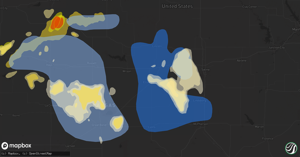
Hail Map in Ellsworth, KS on July 21, 2025
Get this storm
July 21 map
$229
one time, instant access
Download today. No call, no setup
Keep the $229
Bought the map and want the full workflow? Apply the entire $229 to a subscription within 7 days. None of it is wasted.
Every map, not just this one
This buys you this map. Subscription and you get every map we run, in the markets you choose from a few cities to whole states to nationwide. Plus real-time alerts the moment a storm fires.
Contact data
Name, contact info, occupancy, even credit band for addresses in the footprint. You go from where it hit to who to call.
Become the source they trust
Unlimited branding weather history reports on demand. You already have the documented answer ready for the property owner, and you are the one who showed up with it.
Property data and RoofTrace estimates
Pull up any address you have got, its value and the exact code rules for that jurisdiction, straight from One Click Code. Then RoofTrace estimates the squares, pitch, and roof value, priced the way you price.
Storm reports in Ellsworth, KS
Ellsworth, KS
| Date | Description |
|---|---|
| 07/20/20257:54 PM CDT | Reported a semi blown over at mile marker 222 on i-70 from thunderstorm wind gusts. |
| 07/20/20257:35 PM CDT | A local report indicates 63 MPH wind near Ellsworth Airport |
| 07/20/20257:31 PM CDT | A local report indicates 60 MPH wind near 8 SSW Westfall |
All States Impacted by Hail Map on July 21, 2025
All Cities Impacted by Hail Map on July 21, 2025
- Litchfield, MN
- Hitchcock, SD
- Grove City, MN
- Atwater, MN
- Iroquois, SD
- Willow Lake, SD
- Gibbon, MN
- Fairfax, MN
- Franklin, MN
- Carpenter, SD
- Yale, SD
- Bryant, SD
- De Smet, SD
- Mayetta, KS
- Manhattan, KS
- Erwin, SD
- Lake Preston, SD
- Frankfort, KS
- Beatrice, NE
- Jansen, NE
- Plymouth, NE
- Onaga, KS
- Westmoreland, KS
- Havensville, KS
- Corning, KS
- Blue Springs, NE
- Soldier, KS
- Virginia, NE
- Filley, NE
- Goff, KS
- Liberty, NE
- Burchard, NE
- Pawnee City, NE
- Lewiston, NE
- Alden, IA
- Iowa Falls, IA
- Dows, IA
- Seneca, KS
- Du Bois, NE
- Bern, KS
- Sabetha, KS
- Shickley, NE
- Ong, NE
- Ohiowa, NE
- Strang, NE
- Geneva, NE
- Tobias, NE
- Stewart, MN
- Western, NE
- Hutchinson, MN
- Wilber, NE
- Brownton, MN
- Swanton, NE
- Fairbury, NE
- Glencoe, MN
- New Auburn, MN
- Gaylord, MN
- Arlington, MN
- Branford, FL
- Diller, NE
- Odell, NE
- Le Sueur, MN
- Henderson, MN
- Moriarty, NM
- Gaylord, KS
- Atlantic, NC
- Saint Peter, MN
- Portis, KS
- Palatka, FL
- Green Cove Springs, FL
- Centralia, KS
- Cleveland, MN
- San Simon, AZ
- Stanley, NM
- Edgar, NE
- Lebanon, KS
- Madison Lake, MN
- Esbon, KS
- Burr Oak, KS
- Mankato, KS
- Elysian, MN
- Kilkenny, MN
- Saint Augustine, FL
- Gainesville, GA
- Le Center, MN
- Nelson, NE
- Groom, TX
- Panhandle, TX
- Cromwell, KY
- Horse Branch, KY
- Webber, KS
- Superior, NE
- Oak, NE
- Morgantown, KY
- Glen Saint Mary, FL
- Brandon, FL
- Valrico, FL
- Formoso, KS
- Alexandria, NE
- Bruning, NE
- Yulee, FL
- Jacksonville, FL
- Callahan, FL
- White Deer, TX
- Plainville, KS
- Natoma, KS
- Skellytown, TX
- Deshler, NE
- Hebron, NE
- Waterville, MN
- Courtland, KS
- Fernandina Beach, FL
- Alma, GA
- Myakka City, FL
- Ellis, KS
- North Fort Myers, FL
- Hubbell, NE
- Okeechobee, FL
- Inavale, NE
- Morriston, FL
- Stockton, KS
- Narka, KS
- Mahaska, KS
- Reynolds, NE
- Trinchera, CO
- Gillette, WY
- Rozet, WY
- Ashby, NE
- Woodston, KS
- White Springs, FL
- Lake City, FL
- Ocala, FL
- Weston, WY
- Red Cloud, NE
- Merriman, NE
- Morrowville, KS
- Lorida, FL
- Smith Center, KS
- Moorcroft, WY
- Alton, KS
- Wakeeney, KS
- Cookeville, TN
- Arcadia, FL
- Buffalo, OK
- Bingham, NE
- Laverne, OK
- Stratton, NE
- Ashland, KS
- Lake Placid, FL
- Miami, TX
- Gordon, NE
- Paradise, KS
- White Sulphur Springs, MT
- Coldwater, KS
- Protection, KS
- Ogallah, KS
- Canal Point, FL
- Indiantown, FL
- Garryowen, MT
- Avon Park, FL
- Osborne, KS
- Waldo, KS
- Martinsdale, MT
- Fort Stockton, TX
- Chadron, NE
- Balko, OK
- Follett, TX
- Sheridan, WY
- Rosston, OK
- Cedar, KS
- Busby, MT
- Crow Agency, MT
- Venus, FL
- Broadus, MT
- Luray, KS
- Beaver, OK
- Palco, KS
- Wilmore, KS
- Pampa, TX
- Quinter, KS
- Whitney, NE
- Barnard, KS
- Lincoln, KS
- Quitaque, TX
- Collyer, KS
- Guide Rock, NE
- Turkey, TX
- Decker, MT
- Two Dot, MT
- Haviland, KS
- Lucas, KS
- Harlowton, MT
- Shawmut, MT
- Devils Tower, WY
- Forsyth, MT
- Tuthill, SD
- Martin, SD
- Lame Deer, MT
- Sundance, WY
- Upton, WY
- Glen Elder, KS
- Moore Haven, FL
- Beloit, KS
- Tipton, KS
- Hulett, WY
- Birney, MT
- Clancy, MT
- Lubbock, TX
- Jewell, KS
- Belleville, KS
- Tescott, KS
- Sylvan Grove, KS
- Hunter, KS
- Judith Gap, MT
- Brookville, KS
- Beverly, KS
- Pine Ridge, SD
- Ponderosa, NM
- Norway, KS
- East Helena, MT
- Winston, MT
- Oelrichs, SD
- Townsend, MT
- Los Alamos, NM
- Pena Blanca, NM
- Helena, MT
- Rosebud, MT
- Scandia, KS
- Jamestown, KS
- Higgins, TX
- Salina, KS
- Catharine, KS
- Concordia, KS
- Bronson, FL
- Ryegate, MT
- Hathaway, MT
- Otter, MT
- Spearfish, SD
- Ramah, CO
- Claude, TX
- Volborg, MT
- Miles City, MT
- Minneapolis, KS
- Ellsworth, KS
- Kanopolis, KS
- Wilson, KS
- Ralls, TX
- Saint Onge, SD
- Whitewood, SD
- Russell, KS
- Immokalee, FL
- Woodrow, CO
- Akron, CO
- Hays, KS
- Gorham, KS
- Victoria, KS
- Bunker Hill, KS
- Walker, KS
- Lindsborg, KS
- Dorrance, KS
- Belle Fourche, SD
- Lorraine, KS
- Marquette, KS
- Hoisington, KS
- Olmitz, KS
- Pfeifer, KS
- Otis, KS
- McCracken, KS
- Schoenchen, KS
- Bison, KS
- La Crosse, KS
- Liebenthal, KS
- Rankin, TX
- Midkiff, TX
- Wounded Knee, SD
- Batesland, SD
- Wanblee, SD
- Raynesford, MT
- Geyser, MT
- Falun, KS
- Holyrood, KS
- Geneseo, KS
- Kadoka, SD
- Hobson, MT
- Assaria, KS
- Lamar, CO
- Marathon, TX
- Floydada, TX
- Claflin, KS
- Alva, OK
- Ellinwood, KS
- Chase, KS
- Great Bend, KS
- Raymond, KS
- Albert, KS
- Little River, KS
- Mcpherson, KS
- Windom, KS
- Lyons, KS
- Bushton, KS
- Kiowa, KS
- Hardtner, KS
- Newell, SD
- Philip, SD
- Lake City, KS
- Union Center, SD
- Mud Butte, SD
- Faith, SD
- Midland, SD
- Medicine Lodge, KS
- Rush Center, KS
- Sharon, KS
- Meadow, SD
- Pawnee Rock, KS
- Larned, KS
- St John, KS
- Hudson, KS
- Kingman, KS
- Spivey, KS
- Alden, KS
- Sterling, KS
- Utica, KS
- Murdock, KS
- Gove, KS
- Harper, KS
- Cheney, KS
- Galva, KS
- Norwich, KS
- Attica, KS
- Nickerson, KS
- Hutchinson, KS
- Partridge, KS
- Dupree, SD
- Cunningham, KS
- Howes, SD
- Glade, KS
- Lavina, MT
- Haven, KS
- Mount Hope, KS
- Garden Plain, KS
- Goddard, KS
- Argonia, KS
- Milton, KS
- Danville, KS
- Odessa, TX
- Midland, TX
- Matheson, CO
- Abbyville, KS
- Inman, KS
- Roundup, MT
- Wichita, KS
- Haysville, KS
- Clearwater, KS
- Viola, KS
- Derby, KS
- Kechi, KS
- Greenwich, KS
- Andale, KS
- Colwich, KS
- Maize, KS
- Moundridge, KS
- Zortman, MT
- Park, KS
- Big Timber, MT
- South Hutchinson, KS
- Lamesa, TX
- Odonnell, TX
- Kirwin, KS
- Broadview, MT
- Phillipsburg, KS
- Isabel, SD
- Canton, KS
- Eagle Butte, SD
- Conway Springs, KS
- Newton, KS
- Tahoka, TX
- Whitewater, MT
- Mulvane, KS
- Peck, KS
- Towanda, KS
- Benton, KS
- Andover, KS
- Mcconnell Afb, KS
- Augusta, KS
- Douglass, KS
- Rose Hill, KS
- Shepherd, MT
- Worden, MT
- Whitewater, KS
- Timber Lake, SD
- Lantry, SD
- Elbing, KS
- Peabody, KS
- McLaughlin, SD
- Trail City, SD
- Whitehorse, SD
- Glencross, SD
- Udall, KS
- Belle Plaine, KS
- Malta, MT
- Walton, KS
- Valley Center, KS
- Marion, KS
- Potwin, KS
- Cedar Point, KS
- Burns, KS
- Florence, KS
- Elmdale, KS
- Cottonwood Falls, KS
- Buffalo, SD
- Capitol, MT
- Mayfield, KS
- Rock, KS
- Custer, MT
- Wellington, KS
- Camp Crook, SD
- Kensington, KS
- Winfield, KS
- Ekalaka, MT
- Shallowater, TX
- Burden, KS
- Reva, SD
- Mound City, SD
- Wilsall, MT
- Prairie City, SD
- Ludlow, SD
- Saint Cloud, FL
- Bison, SD
- Abernathy, TX
- Agra, KS
- Cedar Vale, KS
- Fort Yates, ND
- Lodgepole, SD
- Saint Anthony, ND
- Solen, ND
- Logan, KS
- Mandan, ND
- Gettysburg, SD
- Lenora, KS
- Kintyre, ND
- Napoleon, ND
- Alma, NE
- Bismarck, ND
- Beaver City, NE
- Sturgis, SD
- Baldwin, ND
- Sedan, KS
- Damar, KS
- Orleans, NE
- Selby, SD
- Oxford, NE
- Hoven, SD
- Almena, KS
- Edison, NE
- Tolstoy, SD
- Arapahoe, NE
- Mercer, ND
- Turtle Lake, ND
- New Salem, ND
- Bowdle, SD
- Roscoe, SD
- Muleshoe, TX
- Balfour, ND
- Harvey, ND
- Butte, ND
- Onaka, SD
- Portales, NM
- Voltaire, ND
- Oral, SD
- Maddock, ND
- Lemmon, SD
- Ralph, SD
- Wahpeton, ND
- York, ND
- Towner, ND
- Leeds, ND
- Tintah, MN
- Garrison, ND
- Mellette, SD
- Northville, SD
- Ashton, SD
- Springer, NM
- Fergus Falls, MN
- Conde, SD
- Arvilla, ND
- Ryder, ND
- Beulah, ND
- Dunn Center, ND
- Halliday, ND
- Killdeer, ND
- Park Rapids, MN
- Nevis, MN
- Durham, KS
- Roxbury, KS
- Lehigh, KS
- Hillsboro, KS
- Goessel, KS
- Hesston, KS
- Halstead, KS
- Sedgwick, KS
- North Newton, KS
- Pretty Prairie, KS
- Burrton, KS
- Bentley, KS
- Buhler, KS
- Arlington, KS
- Sylvia, KS
- Turon, KS
- Plevna, KS
- Stafford, KS
- Garfield, KS
- Kinsley, KS
- Lewis, KS
- Belpre, KS
- Byers, KS
- Iuka, KS
- Pratt, KS
- Macksville, KS
- Sawyer, KS
- Coats, KS
- Isabel, KS
- Atlanta, KS
- El Dorado, KS
- Leon, KS
- Piedmont, KS
- Cassoday, KS
- Matfield Green, KS
- Rosalia, KS
- Eureka, KS


