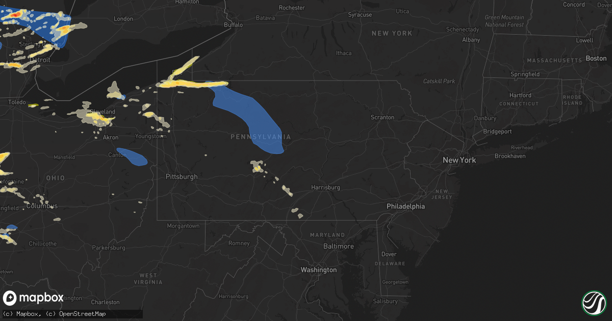
Hail Map in Pennsylvania on July 20, 2023
Get this storm
July 20 map
$229
one time, instant access
Download today. No call, no setup
Keep the $229
Bought the map and want the full workflow? Apply the entire $229 to a subscription within 7 days. None of it is wasted.
Every map, not just this one
This buys you this map. Subscription and you get every map we run, in the markets you choose from a few cities to whole states to nationwide. Plus real-time alerts the moment a storm fires.
Contact data
Name, contact info, occupancy, even credit band for addresses in the footprint. You go from where it hit to who to call.
Become the source they trust
Unlimited branding weather history reports on demand. You already have the documented answer ready for the property owner, and you are the one who showed up with it.
Property data and RoofTrace estimates
Pull up any address you have got, its value and the exact code rules for that jurisdiction, straight from One Click Code. Then RoofTrace estimates the squares, pitch, and roof value, priced the way you price.
Storm reports in Pennsylvania
Pennsylvania
| Date | Description |
|---|---|
| 07/20/20236:57 PM CDT | Trees down on route 322 |
| 07/20/20236:53 PM CDT | Tree down |
| 07/20/20236:51 PM CDT | Trees and wires down |
| 07/20/20236:48 PM CDT | Trees down in and around sharon |
| 07/20/20236:42 PM CDT | Trees down in and around west salem township. |
| 07/20/20236:40 PM CDT | Multiple trees and wires down in the tidioute area. |
| 07/20/20236:39 PM CDT | Trees down on hatch run rd. |
| 07/20/20236:33 PM CDT | Trees down in and around sandy lake |
| 07/20/20236:29 PM CDT | Wires down on route 426 and chappy rd. |
| 07/20/20236:12 PM CDT | Multiple trees and wires down in the conneautville... Venango... And cambridge springs areas. |
| 07/20/20236:11 PM CDT | Reports of golf ball size hail in sugar grove. |
| 07/20/20235:30 PM CDT | North side of corry... Pa. |
| 07/20/20235:15 PM CDT | Hail damaged some vehicles and also tore off window screens. |
| 07/20/20235:05 PM CDT | A local report indicates 1.00 inch wind near 1 W Union City |
| 07/20/20234:54 PM CDT | A local report indicates 1.50 inch wind near 3 S Mckean |
| 07/20/20234:10 PM CDT | Report from mping: quarter |
| 07/20/202312:46 PM CDT | -delayed report- multiple large trees downed across road 3 miles east of downtown erie. |
| 07/20/202312:43 PM CDT | -delayed report- video and photos of hail approximately the size of half dollars 3 miles east of downtown erie. |
| 07/20/202312:39 PM CDT | Various hail sizes from penny to quarter size. |
| 07/20/202310:35 AM CDT | Multiple reports of trees down across eastern lycoming county. |
| 07/20/20238:33 AM CDT | Multiple trees down reported on clay plant road just outside the town of brockway. |
| 07/20/20232:57 AM CDT | Tree down on pa rt 32. Time estimated from radar. |
| 07/20/20232:46 AM CDT | Large branch down at morris road and west point pike. |
| 07/20/20232:46 AM CDT | Delayed report... Large tree limb across road on rte 313 southbound near ferry road. Time estimated from radar. |
| 07/20/20232:35 AM CDT | Peco reports trees down near the marple crossroads shopping center. Time estimated from radar. |
| 07/20/20232:35 AM CDT | Tree limbs down on wires. Time estimated from radar. |
| 07/20/20232:19 AM CDT | Tree down on us rt 1. Time estimated from radar. |
| 07/20/20232:16 AM CDT | Tree limbs down on wires. Time estimated from radar. |
| 07/20/20232:11 AM CDT | Tree limbs down on wires on bethel church rd. Time estimated from radar. |
| 07/20/20232:02 AM CDT | Tree down on house. |
| 07/20/20231:49 AM CDT | Tree down on cedar hill road. |
| 07/20/20231:46 AM CDT | Tree limbs on wires. Time estimated from radar. |
| 07/20/20231:34 AM CDT | Jcpl reports tree damage on new holland rd. Time estimated from radar. |
| 07/20/20231:16 AM CDT | Tree down on huntzinger road. |
| 07/20/202312:46 AM CDT | Tree fell through a roof. |
| 07/20/202312:39 AM CDT | Tree down on i-83. |
| 07/20/202312:35 AM CDT | 1 tree down on sacramento ct and 1 tree snapped off in a yard. |
| 07/20/202312:29 AM CDT | Corrects previous tstm wnd dmg report from 1 nnw hogestown. Tree down blocking southbound lane of carlisle pike. |
| 07/20/202312:25 AM CDT | Tree down on road. |
| 07/20/202312:13 AM CDT | Trees down. |
| 07/20/202312:13 AM CDT | Tree down on campsite. |
| 07/20/202312:00 AM CDT | Tree down on i-81 blocking the right lane. |
| 07/19/202311:44 PM CDT | Tree down on road. |
| 07/19/202310:35 PM CDT | Multiple reports of trees down across eastern lycoming county. |
| 07/19/202310:10 PM CDT | .75 inch to 1 inch hail fell for 5 minutes during a heavy rain downpour. |
| 07/19/20239:59 PM CDT | Multiple trees down in tyrone. |
| 07/19/20239:57 PM CDT | Multiple trees down in the vicinity of altoona and hollidaysburg. |
| 07/19/20239:55 PM CDT | Trees down on abbott run rd. |
| 07/19/20239:45 PM CDT | Report of power lines down in area. Time estimated based on radar. |
| 07/19/20239:45 PM CDT | Trees on wires behind 1227 isabella street. |
| 07/19/20239:35 PM CDT | Trees and wires down on green mountain rd. |
| 07/19/20239:29 PM CDT | Trees down in mansfield. |
| 07/19/20239:25 PM CDT | Trees down on buffalo run rd near fillmore. |
| 07/19/20239:22 PM CDT | Report of multiple trees down along state route 933 going from trafford to north huntington township. Time estimated based on radar. |
| 07/19/20239:20 PM CDT | Several trees and wires down in the lock haven area. |
| 07/19/20239:20 PM CDT | Tree down at atherton st and stevenson rd. |
| 07/19/20239:12 PM CDT | Wind damage to a 30ft 60ft flat rubber roof striped from the roof structure and 200ft of gutter torn from the structure. |
| 07/19/20238:45 PM CDT | Large tree down across the road at 9582 renovo rd. |
| 07/19/20238:34 PM CDT | Report of trees down in the area. Time estimated based on radar. |
| 07/19/20238:33 PM CDT | Multiple trees down reported on clay plant road just outside the town of brockway. |
| 07/19/20238:33 PM CDT | Tree on wires at 43 good street in clearfield. |
| 07/19/20238:32 PM CDT | Report of a few trees down in the area. Time estimated based on radar. |
| 07/19/20238:17 PM CDT | Multiple trees down in genesee. |
| 07/19/20238:01 PM CDT | Trees on wires in austin... Pa. |
| 07/19/20237:57 PM CDT | Trees across north creek rd. |
| 07/19/20237:55 PM CDT | Multiple trees down in penfield... Including one on a house. |
| 07/19/20237:54 PM CDT | Report of trees down in franklin township. Time estimated based on radar. |
| 07/19/20237:48 PM CDT | Report of downed tree on southbound lane of route 8. Time estimated based on radar. |
| 07/19/20237:45 PM CDT | Trees down on route 155 near two mile rd. |
| 07/19/20237:44 PM CDT | Report of trees and power lines down in the area. Time estimated based on radar. |
| 07/19/20237:40 PM CDT | Report of trees and power lines down in the area. Time estimated based on radar. |
| 07/19/20237:34 PM CDT | Multiple reports of trees and wires down along us 6 near smethport. |
| 07/19/20237:32 PM CDT | Report of trees down in the area. Time estimated based on radar. |
| 07/19/20237:32 PM CDT | Report of trees and power lines down in the area. Time estimated based on radar. |
| 07/19/20237:29 PM CDT | Trees and wires down on old red mill dam rd. |
| 07/19/20237:27 PM CDT | Trees and wires down on silver creek rd. |
| 07/19/20237:24 PM CDT | Report of tree down in area. Time estimated based on radar. |
| 07/19/20237:24 PM CDT | Trees down |
| 07/19/20237:24 PM CDT | Report of multiple trees and power lines down in area. Time estimated based on radar. |
| 07/19/20237:23 PM CDT | Trees down |
| 07/19/20237:22 PM CDT | *** 1 inj *** report of tree down on vehicle with only minor injury noted for inhabitant. Time estimated based on radar |
| 07/19/20237:22 PM CDT | Report of tree down in area. Time estimated based on radar. |
| 07/19/20237:22 PM CDT | Report of multiple trees and power lines down in area. Time estimated based on radar. |
| 07/19/20237:22 PM CDT | *** 1 inj *** report of tree down on vehicle with only minor injury noted for inhabitant. Time estimated based on radar |
| 07/19/20237:21 PM CDT | Report of tree down on greenwood road in barnett township. Time estimated based on radar. |
| 07/19/20237:20 PM CDT | Report of tree down on greenwood road. Time estimated based on radar. |
| 07/19/20237:19 PM CDT | Reports of numerous trees and powerlines downs in pine township. |
| 07/19/20237:18 PM CDT | Report of numerous trees and powerlines down around grove city. Time estimated based on radar. |
| 07/19/20237:18 PM CDT | Report of tree down blocking westbound lane near country farm supply. Time estimated based on radar. |
| 07/19/20237:15 PM CDT | Trees down in lewis run borough. |
| 07/19/20237:04 PM CDT | Report of tree down on job corps road in jenks township. Time estimated based on radar. |
All States Impacted by Hail Map on July 20, 2023
Cities Impacted by Hail Map on July 20, 2023
- Bonne Terre, MO
- Farmington, MO
- Roodhouse, IL
- White Hall, IL
- Greenfield, IL
- Hettick, IL
- New Berlin, IL
- Carlinville, IL
- Shipman, IL
- Gillespie, IL
- Paducah, KY
- Brookport, IL
- Ledbetter, KY
- Gilbertsville, KY
- Smithland, KY
- Calvert City, KY
- Grand Rivers, KY
- Kuttawa, KY
- Eddyville, KY
- Sterling, CO
- Iliff, CO
- Princeton, KY
- Cadiz, KY
- Cerulean, KY
- Gracey, KY
- Crofton, KY
- Hopkinsville, KY
- Fleming, CO
- Pembroke, KY
- Trenton, KY
- Elkton, KY
- Guthrie, KY
- Clarksville, TN
- Allensville, KY
- Adams, TN
- Olmstead, KY
- Springfield, TN
- Cedar Hill, TN
- Adairville, KY
- Greenbrier, TN
- White House, TN
- Goodlettsville, TN
- Hendersonville, TN
- Cottontown, TN
- Madison, TN
- Gallatin, TN
- Bannister, MI
- Brant, MI
- Elsie, MI
- Ashley, MI
- Oakley, MI
- Henderson, MI
- Chesaning, MI
- Old Hickory, TN
- Mount Juliet, TN
- Lebanon, TN
- Hermitage, TN
- Stewart, TN
- Metropolis, IL
- Jacksonville, IL
- Murrayville, IL
- Carlyle, IL
- Winchester, IL
- Sheridan, MI
- French Village, MO
- Sedgewickville, MO
- Friedheim, MO
- Perryville, MO
- Greenville, MI
- Edwardsville, IL
- Padroni, CO
- Waterloo, IL
- Grand Chain, IL
- Sainte Genevieve, MO
- Saint Mary, MO
- Stanton, MI
- Hersey, MI
- Reed City, MI
- Evart, MI
- Oak Ridge, MO
- Daisy, MO
- Patton, MO
- Ullin, IL
- Olmsted, IL
- Kevil, KY
- Pulaski, IL
- Alexander, IL
- Jackson, MO
- Cape Girardeau, MO
- Jonesboro, IL
- McClure, IL
- Lake City, PA
- East Springfield, PA
- Girard, PA
- Osage Beach, MO
- Kaiser, MO
- Linn Creek, MO
- Thebes, IL
- Tamms, IL
- Kirk, CO
- Lakeview, MI
- Pocahontas, IL
- Crossville, TN
- Oak Grove, KY
- Pentwater, MI
- Ludington, MI
- Orlinda, TN
- Benld, IL
- Chesterfield, IL
- Sidney, MI
- Fredericktown, MO
- Russellville, KY
- Howard City, MI
- Morley, MI
- Fort Campbell, KY
- Potosi, MO
- Alhambra, IL
- Livingston, IL
- Staunton, IL
- New Douglas, IL
- Baxter, TN
- Gowen, MI
- De Soto, MO
- Valles Mines, MO
- Aviston, IL
- Festus, MO
- Bloomsdale, MO
- Rockford, MI
- Merino, CO
- Lake, MI
- Breese, IL
- Highland, IL
- Palmyra, IL
- Sawyerville, IL
- Mount Olive, IL
- Golden Eagle, IL
- Bunker Hill, IL
- Wilsonville, IL
- Fenwick, MI
- Vestaburg, MI
- Six Lakes, MI
- Coral, MI
- Newaygo, MI
- Trufant, MI
- White Cloud, MI
- Crystal, MI
- Moro, IL
- Mounds, IL
- Olive Branch, IL
- Villa Ridge, IL
- Brumley, MO
- La Center, KY
- Barlow, KY
- Dongola, IL
- West Paducah, KY
- Karnak, IL
- Cypress, IL
- Stoneham, CO
- Park Hills, MO
- Murfreesboro, TN
- New Lothrop, MI
- Owosso, MI
- Montrose, MI
- Corunna, MI
- Dewitt, MI
- Bath, MI
- Laingsburg, MI
- Flint, MI
- Clio, MI
- Flushing, MI
- Lennon, MI
- Swartz Creek, MI
- Mount Morris, MI
- Fairview, PA
- Erie, PA
- McKean, PA
- Harborcreek, PA
- North East, PA
- Ripley, NY
- Burton, MI
- Davison, MI
- Genesee, MI
- Schoolcraft, MI
- Vicksburg, MI
- Lapeer, MI
- Lascassas, TN
- Auburntown, TN
- Watertown, TN
- Milton, TN
- Liberty, TN
- Alexandria, TN
- Dowelltown, TN
- Smithville, TN
- Woodbury, TN
- Readyville, TN
- Mcminnville, TN
- Bradyville, TN
- Morrison, TN
- Saint Johns, MI
- Ovid, MI
- Durand, MI
- Holt, MI
- Leslie, MI
- Mason, MI
- Dansville, MI
- Williamston, MI
- Webberville, MI
- Fowlerville, MI
- Stockbridge, MI
- Brighton, MI
- Gregory, MI
- Howell, MI
- Pinckney, MI
- Capac, MI
- Imlay City, MI
- Allenton, MI
- Almont, MI
- Dryden, MI
- Otisville, MI
- Grand Blanc, MI
- Goodrich, MI
- Atlas, MI
- Oxford, MI
- Metamora, MI
- Hadley, MI
- Ortonville, MI
- Columbiaville, MI
- Detroit, MI
- Highland Park, MI
- Ferndale, MI
- Warren, MI
- Hamtramck, MI
- Hazel Park, MI
- South Bend, IN
- Mishawaka, IN
- Osceola, IN
- Eastpointe, MI
- Saint Clair Shores, MI
- Roseville, MI
- Harper Woods, MI
- Avoca, MI
- Emmett, MI
- Jeddo, MI
- North Street, MI
- Clinton Township, MI
- Harrison Township, MI
- Elkhart, IN
- Goshen, IN
- Clarkston, MI
- Rock Island, TN
- Fort Gratiot, MI
- Center Line, MI
- Bennett, CO
- Columbus, MI
- Saint Clair, MI
- Casco, MI
- East China, MI
- Marysville, MI
- Divide, CO
- Woodland Park, CO
- Green Mountain Falls, CO
- Cascade, CO
- Colorado Springs, CO
- Attica, MI
- Romeo, MI
- Washington, MI
- Leonard, MI
- Rochester, MI
- Oakland, MI
- Ray, MI
- Macomb, MI
- Utica, MI
- Armada, MI
- New Baltimore, MI
- New Haven, MI
- Harsens Island, MI
- Fair Haven, MI
- Algonac, MI
- Marine City, MI
- Richmond, MI
- Smiths Creek, MI
- Goodells, MI
- Memphis, MI
- Yale, MI
- Port Huron, MI
- Manitou Springs, CO
- Middlebury, IN
- Millersburg, IN
- Elizabeth, CO
- Albion, PA
- Cranesville, PA
- Edinboro, PA
- Kiowa, CO
- West Springfield, PA
- Ypsilanti, MI
- Ann Arbor, MI
- Canton, MI
- Belleville, MI
- Wayne, MI
- Dexter, MI
- Chelsea, MI
- Peyton, CO
- Elbert, CO
- Strasburg, CO
- Byers, CO
- Fort Morgan, CO
- Calhan, CO
- Ramah, CO
- Wallace, KS
- Sharon Springs, KS
- Leoti, KS
- Winona, KS
- Marienthal, KS
- Scott City, KS
- Simla, CO
- Boncarbo, CO
- Trinidad, CO
- Waterford, PA
- Holcomb, KS
- Garden City, KS
- Deerfield, KS
- Yoder, CO
- Union City, PA
- Walsenburg, CO
- Lakin, KS
- Wakeman, OH
- Oberlin, OH
- Chardon, OH
- Brookpark, OH
- Montville, OH
- Norwalk, OH
- Jefferson, OH
- Wellington, OH
- Beachwood, OH
- Grafton, OH
- New London, OH
- Kingsville, OH
- Independence, OH
- Berea, OH
- Springboro, PA
- Rock Creek, OH
- Pierpont, OH
- North Fairfield, OH
- Lagrange, OH
- Conneaut, OH
- Gates Mills, OH
- Olmsted Falls, OH
- Chesterland, OH
- Collins, OH
- Cleveland, OH
- Thompson, OH
- Columbia Station, OH
- Martin, OH
- Graytown, OH
- Oak Harbor, OH
- Curtice, OH
- Matheson, CO
- Denver, CO
- Morrison, CO
- Golden, CO
- Ingalls, KS
- Wattsburg, PA
- Littleton, CO
- Englewood, CO
- Canon City, CO
- Penrose, CO
- Fort Wayne, IN
- Yoder, IN
- Hoagland, IN
- Decatur, IN
- Monroeville, IN
- Ohio City, OH
- Convoy, OH
- Van Wert, OH
- Rush, CO
- Fowler, CO
- Chatsworth, GA
- Dalton, GA
- Ellijay, GA
- Calhoun, GA
- Resaca, GA
- Ranger, GA
- Talking Rock, GA
- Fairmount, GA
- Waleska, GA
- Jasper, GA
- Ball Ground, GA
- Canton, GA
- Alpharetta, GA
- Tate, GA
- Suwanee, GA
- Gainesville, GA
- Marble Hill, GA
- Dawsonville, GA
- Flowery Branch, GA
- Cumming, GA
- Buford, GA
- Corry, PA
- Cimarron, KS
- Florence, CO
- Wapakoneta, OH
- Lima, OH
- Manzanola, CO
- Harrod, OH
- Lafayette, OH
- Ada, OH
- Alger, OH
- Ordway, CO
- Hugo, CO
- Roggen, CO
- Mentor, OH
- Painesville, OH
- Grand River, OH
- Bluffton, OH
- Pueblo, CO
- Forest, OH
- Dunkirk, OH
- Sugar City, CO
- Rocky Ford, CO
- Olney Springs, CO
- Oakwood, GA
- Pendergrass, GA
- Talmo, GA
- Hoschton, GA
- Braselton, GA
- Jefferson, GA
- Dacula, GA
- Auburn, GA
- Lawrenceville, GA
- Winder, GA
- Statham, GA
- Bogart, GA
- Athens, GA
- Watkinsville, GA
- Colbert, GA
- Arnoldsville, GA
- Lexington, GA
- Crawford, GA
- Winterville, GA
- Nicholson, GA
- Lakeview, OH
- Huntsville, OH
- Belle Center, OH
- La Junta, CO
- Roundhead, OH
- Karval, CO
- Columbus, PA
- Bear Lake, PA
- Spring Creek, PA
- Youngsville, PA
- Pittsfield, PA
- Sugar Grove, PA
- Warren, PA
- Dodge City, KS
- Wright, KS
- Avon, OH
- Westlake, OH
- Bay Village, OH
- Rocky River, OH
- Arlington, CO
- North Olmsted, OH
- Model, CO
- Deer Trail, CO
- Russell, PA
- Spearville, KS
- Stephens, GA
- Rayle, GA
- Washington, GA
- Byron, MI
- Perry, MI
- Saint Charles, MI
- Central City, CO
- Black Hawk, CO
- Toney, AL
- Athens, AL
- Lancaster, TN
- South Lyon, MI
- Commerce Township, MI
- Downey, ID
- Lake Orion, MI
- South Pittsburg, TN
- Tracy City, TN
- Sequatchie, TN
- Monteagle, TN
- Three Rivers, MI
- Constantine, MI
- Dimondale, MI
- Eaton Rapids, MI
- Potterville, MI
- Wartrace, TN
- Shelbyville, TN
- Normandy, TN
- Aguilar, CO
- Walling, TN
- Copperhill, TN
- Blue Ridge, GA
- McCaysville, GA
- Ashtabula, OH
- Suches, GA
- Dahlonega, GA
- Belvidere, TN
- Huntland, TN
- Parker, CO
- Flintstone, GA
- Sparta, TN
- Quebeck, TN
- Linden, MI
- Woodrow, CO
- Akron, CO
- Edon, OH
- Montpelier, OH
- East Lansing, MI
- Okemos, MI
- Haslett, MI
- Laotto, IN
- Auburn, IN
- Leo, IN
- Garrett, IN
- Huntertown, IN
- Evergreen, CO
- Waterford, MI
- Farmington, MI
- Novi, MI
- Livonia, MI
- Northville, MI
- Springport, MI
- Onondaga, MI
- Olivet, MI
- Rives Junction, MI
- Jackson, MI
- Bellevue, MI
- Charlotte, MI
- Pulaski, TN
- Prospect, TN
- Leoma, TN
- Goodspring, TN
- Maxwell, NM
- Raton, NM
- Cross Plains, TN
- West Lafayette, IN
- Lafayette, IN
- Westpoint, IN
- Hollytree, AL
- Princeton, AL
- Estillfork, AL
- New Market, AL
- Angola, IN
- Sterling Heights, MI
- Weston, CO
- Saline, MI
- Neoga, IL
- Trilla, IL
- Windsor, IL
- Strasburg, IL
- Clermont, GA
- Cornelia, GA
- Lula, GA
- Alto, GA
- Trenton, GA
- Morganton, GA
- Mineral Bluff, GA
- Darlington, IN
- Albion, IN
- Pierceton, IN
- Larwill, IN
- Kimmell, IN
- Cromwell, IN
- North Webster, IN
- South Whitley, IN
- Mendon, MI
- Antwerp, OH
- Woodburn, IN
- Grabill, IN
- Harlan, IN
- Manning, SC
- Manchester, TN
- Epworth, GA
- Tampa, FL
- Brandon, FL
- Riverview, FL
- Fraser, MI
- Redford, MI
- Tullahoma, TN
- Laramie, WY
- Fowler, MI
- Maple Rapids, MI
- Georgetown, IL
- Westville, IL
- Saint Marys, OH
- Chattanooga, TN
- Whiteside, TN
- Cayuga, IN
- Decatur, TN
- Dayton, TN
- Kremmling, CO
- Granger, IN
- Milford, IN
- Leesburg, IN
- Turtletown, TN
- Benton, TN
- Calhoun, TN
- Reliance, TN
- Riceville, TN
- Charleston, TN
- Old Fort, TN
- Delano, TN
- Spencerville, IN
- Lansing, MI
- Madison, AL
- Huntsville, AL
- Harvest, AL
- Centreville, MI
- Jones, MI
- Ridge Farm, IL
- Kingman, IN
- Dana, IN
- Catlin, IL
- Indianola, IL
- Etna Green, IN
- Winona Lake, IN
- Arcola, IN
- Ossian, IN
- Warsaw, IN
- Roanoke, IN
- Columbia City, IN
- New Haven, IN
- Buena Vista, NM
- Terre Haute, IN
- Troy, MI
- New Paris, IN
- Syracuse, IN
- Ligonier, IN
- Mount Clemens, MI
- Carson City, MI
- Hubbardston, MI
- Clayton, IN
- Stilesville, IN
- Monrovia, IN
- Claypool, IN
- Fenton, MI
- Holly, MI
- Davisburg, MI
- West Terre Haute, IN
- Nappanee, IN
- Avilla, IN
- New Carlisle, IN
- Churubusco, IN
- Kendallville, IN
- Wawaka, IN
- Topeka, IN
- Lake George, CO
- Bloomfield Hills, MI
- Birmingham, MI
- Clawson, MI
- Franklin, MI
- West Bloomfield, MI
- Royal Oak, MI
- Southfield, MI
- Whitwell, TN
- New Boston, MI
- Allen Park, MI
- Dearborn Heights, MI
- Dearborn, MI
- Romulus, MI
- Melvindale, MI
- Taylor, MI
- Inkster, MI
- Westland, MI
- Farmdale, OH
- Cortland, OH
- Watkins, CO
- Aurora, CO
- Portland, TN
- Otterbein, IN
- Plymouth, MI
- Guild, TN
- Crawfordsville, IN
- Thorntown, IN
- Advance, IN
- Lebanon, IN
- Jamestown, IN
- Petersburg, TN
- Mulberry, TN
- Fayetteville, TN
- Munith, MI
- Grass Lake, MI
- Kelso, TN
- Flintville, TN
- Elora, TN
- Sherwood, TN
- Silver Point, TN
- Franktown, CO
- Fort Payne, AL
- Mentone, AL
- Valley Head, AL
- Castle Rock, CO
- Rock River, WY
- Middleton, MI
- Hollywood, AL
- Stevenson, AL
- Scottsboro, AL
- Hazel Green, AL
- Fackler, AL
- Meridianville, AL
- Woodville, AL
- Flat Rock, AL
- Sumner, MI
- North Bloomfield, OH
- Riverview, MI
- Trenton, MI
- Grosse Ile, MI
- Wyandotte, MI
- Southgate, MI
- Florissant, CO
- Lynchburg, TN
- Pikeville, TN
- Perrinton, MI
- Blairsville, GA
- Athens, TN
- Cleveland, TN
- Georgetown, TN
- Mooresville, IN
- Belfast, TN
- Sherwood, MI
- Leonidas, MI
- Colon, MI
- Pisgah, AL
- Lowell, MI
- Saranac, MI
- New Knoxville, OH
- New Bremen, OH
- Celina, OH
- Marshall, MI
- Bancroft, MI
- Cleveland, GA
- Bourbon, IN
- Cherry Log, GA
- Ithaca, MI
- Grand Ledge, MI
- Pewamo, MI
- Muir, MI
- Beersheba Springs, TN
- Altamont, TN
- Genoa, CO
- Limon, CO
- Las Animas, CO
- Lincoln Park, MI
- Bucklin, KS
- Offerle, KS
- Mullinville, KS
- Ford, KS
- Greensburg, KS
- Haviland, KS
- Kinsley, KS
- Irvine, PA
- Clarendon, PA
- Sheffield, PA
- Tionesta, PA
- Ludlow, PA
- Lewis Run, PA
- James City, PA
- Marienville, PA
- Mount Jewett, PA
- Kane, PA
- Tiona, PA
- Wilcox, PA
- Johnsonburg, PA
- Ridgway, PA
- Smethport, PA
- Saint Marys, PA
- Hazel Hurst, PA
- Coats, KS
- Pratt, KS
- Cheraw, CO
- Arriba, CO
- Flagler, CO
- Hasty, CO
- Piqua, OH
- Troy, OH
- Covington, OH
- Emporium, PA
- Kersey, PA
- Force, PA
- Benezett, PA
- Byrnedale, PA
- Weedville, PA
- Clearfield, PA
- Crosby, PA
- Driftwood, PA
- Penfield, PA
- Frenchville, PA
- Kim, CO
- Middlebranch, OH
- Canton, OH
- North Canton, OH
- Alliance, OH
- Louisville, OH
- Paris, OH
- Robertsville, OH
- East Canton, OH
- Minerva, OH
- Homeworth, OH
- Kensington, OH
- East Rochester, OH
- Carrollton, OH
- Mechanicstown, OH
- Salem, OH
- Salineville, OH
- Beloit, OH
- Lisbon, OH
- Summitville, OH
- Hanoverton, OH
- Woodland, PA
- Karthaus, PA
- Sinnamahoning, PA
- Beech Creek, PA
- Pottersdale, PA
- Westport, PA
- Morrisdale, PA
- Wilmington, OH
- Jamestown, OH
- Sabina, OH
- Jeffersonville, OH
- Washington Court House, OH
- Bigler, PA
- Mineral Springs, PA
- West Decatur, PA
- Hammondsville, OH
- Wellsville, OH
- Burlington, CO
- Arapahoe, CO
- Lamar, CO
- Pritchett, CO
- Springfield, CO
- Julian, PA
- Philipsburg, PA
- Drifting, PA
- Grassflat, PA
- Snow Shoe, PA
- Winburne, PA
- Allport, PA
- Hawk Run, PA
- Clarence, PA
- Wallaceton, PA
- Munson, PA
- Lanse, PA
- Kylertown, PA
- Moshannon, PA
- Osceola Mills, PA
- Port Matilda, PA
- Bellefonte, PA
- State College, PA
- Fleming, PA
- Orviston, PA
- Walsh, CO
- Two Buttes, CO
- Langston, AL
- Guntersville, AL
- Albertville, AL
- Groveoak, AL
- Geraldine, AL
- Vilas, CO
- Weskan, KS
- Tribune, KS
- University Park, PA
- Crossville, AL
- Syracuse, KS
- Campo, CO
- Elkhart, KS
- Goodwell, OK
- Boise City, OK
- Keyes, OK
- Hudson, OH
- Twinsburg, OH
- Northfield, OH
- Macedonia, OH
- Bellaire, OH
- Saint Clairsville, OH
- Jacobsburg, OH
- Brecksville, OH
- Broadview Heights, OH
- Strongsville, OH
- Carlton, GA
- Elberton, GA
- Orwell, OH
- Idledale, CO
- Otis, CO
- Cedartown, GA
- Archbold, OH
- Cope, CO
- Anton, CO
- West Unity, OH
- West Liberty, OH
- Rosewood, OH
- East Liberty, OH
- Plain City, OH
- Conover, OH
- North Lewisburg, OH
- Cable, OH
- Saint Paris, OH
- Irwin, OH
- Zanesfield, OH
- Marysville, OH
- Urbana, OH
- Milford Center, OH
- Woodstock, OH
- De Graff, OH
- Mingo, OH
- Glen Easton, WV
- Cameron, WV
- Moundsville, WV
- Proctor, WV
- Lawrenceburg, TN
- London, OH
- Jackson Center, OH
- Lewistown, OH
- Murrayville, GA
- Glen Dale, WV
- Dawson, AL
- Fyffe, AL
- Grant, AL
- Bancroft, ID
- Wren, OH
- Willshire, OH
- Mentone, IN
- Gadsden, AL
- Vienna, OH
- Brookfield, OH
- Centerville, PA
- Russia, OH
- Fletcher, OH
- Bradford, OH
- Houston, OH
- Versailles, OH
- Medina, OH
- Seville, OH
- Burkettsville, OH
- Rossburg, OH
- New Weston, OH
- Saint Henry, OH
- Fort Recovery, OH
- Waynesfield, OH
- Lakewood, OH
- North Ridgeville, OH
- Bedford, OH
- Edgefield, SC
- Jetmore, KS
- Agate, CO
- Clarks Mills, PA
- Hull, GA
- Huntington, IN
- Rockford, OH
- Markle, IN
- Mendon, OH
- Zanesville, IN
- Homer, GA
- Anna, OH
- Dayton, OH
- Keenesburg, CO
- Hudson, CO
- Brush, CO
- Section, AL
- New Hope, AL
- Gurley, AL
- Brownsboro, AL
- Owens Cross Roads, AL
- Madison, OH
- Geneva, OH
- Joes, CO
- Rome, OH
- Andover, OH
- Dorset, OH
- Myrtle Beach, SC
- North Royalton, OH
- Saint Stephen, SC
- Jamestown, SC
- Sidney, OH
- Sapello, NM
- New Vienna, OH
- Commerce, GA
- Comer, GA
- Clifton, ID
- Kit Carson, CO
- Lane, SC
- Pineville, SC
- New Hampshire, OH
- Rushsylvania, OH
- Russells Point, OH
- Unionville, TN
- Yorkshire, OH
- Centre, AL
- Leesburg, AL
- Danielsville, GA
- Williamsfield, OH
- Rockvale, TN
- Christiana, TN
- Henagar, AL
- Dutton, AL
- Boone, CO
- Oregonia, OH
- Pioneer, OH
- Leesburg, OH
- Greenville, PA
- Transfer, PA
- Parshall, CO
- Collinsville, AL
- Orlando, FL
- Longs, SC
- Farrell, PA
- West Middlesex, PA
- Wheatland, PA
- Hubbard, OH
- Hermitage, PA
- Kinsman, OH
- Cambridge Springs, PA
- Port Clinton, OH
- North Myrtle Beach, SC
- Avon Lake, OH
- Sheffield Lake, OH
- Elyria, OH
- Lorain, OH
- Maysville, GA
- Carnesville, GA
- Hilliard, OH
- Columbus, OH
- Litchfield, OH
- Bellefontaine, OH
- Lester, AL
- Greeleyville, SC
- Richwood, OH
- Middle Bass, OH
- Put In Bay, OH
- Lindon, CO
- Bell Buckle, TN
- Wesley Chapel, FL
- Cheyenne Wells, CO
- Mason, TN
- Drummonds, TN
- Osceola, AR
- Atoka, TN
- Munford, TN
- Brighton, TN
- Henning, TN
- Covington, TN
- Burlison, TN
- Dublin, OH
- Monroeville, OH
- Gillsville, GA
- Powell, OH
- Westerville, OH
- Punta Gorda, FL
- Hinckley, OH
- Clarksville, OH
- Waynesville, OH
- New Wilmington, PA
- Mercer, PA
- Ballard, WV
- Piedmont, AL
- Lancaster, OH
- Carroll, OH
- Pulaski, PA
- Kittanning, PA
- Austinburg, OH
- Zephyrhills, FL
- Dade City, FL
- Lewisburg, TN
- Port William, OH
- Haviland, OH
- Grover Hill, OH
- Sandusky, OH
- Columbus Grove, OH
- Beallsville, OH
- West Jefferson, OH
- Marietta, GA
- Fredonia, PA
- Sharpsville, PA
- Burghill, OH
- Xenia, OH
- Harveysburg, OH
- Chagrin Falls, OH
- Solon, OH
- Amherst, OH
- Richfield, OH
- Valley City, OH
- Brunswick, OH
- Ridgeway, OH
- Botkins, OH
- Montezuma, OH
- Uniopolis, OH
- Dola, OH
- Jenera, OH
- Pickerington, OH
- Reynoldsburg, OH
- Dallas, GA
- Jackson, TN
- Humboldt, TN
- Hugoton, KS
- Rolla, KS
- Turpin, OK
- Liberal, KS
- Kismet, KS
- Forgan, OK
- Gate, OK
- Laverne, OK
- Beaver, OK
- Texhoma, OK
- Maple Heights, OH
- Meade, KS
- Minneola, KS
- Fowler, KS
- Mattoon, IL
- Drummond, OK
- Lahoma, OK
- Enid, OK
- Waukomis, OK
- Fairmont, OK
- Covington, OK
- Garber, OK
- Perry, OK
- Rye, CO
- Cameron, SC
- Blairs Mills, PA
- Shade Gap, PA
- Oakland, TN
- Sheridan Lake, CO
- Burlington, WV
- Purgitsville, WV
- Romney, WV
- Beulah, CO
- Montezuma, KS
- Arlington, TN
- Stanton, TN
- Cordova, TN
- Rossville, TN
- Memphis, TN
- Millington, TN
- Eads, TN
- Somerville, TN
- Williston, TN
- Kimbolton, OH
- Keyser, WV
- Newburg, WV
- Independence, WV
- Reedsville, WV
- Kingwood, WV
- Georgetown, SC
- Colorado City, CO
- Sardis, TN
- Saltillo, TN
- Belmont, OH
- Enville, TN
- Lexington, TN
- Reagan, TN
- Bison, OK
- Hennessey, OK
- Fairfield, PA
- Orrtanna, PA
- Spring Run, PA
- Newburg, PA
- Grenville, NM
- Minor Hill, TN
- Willis, MI
- Mapleton Depot, PA
- Huntingdon, PA
- Medina, TN
- Fayetteville, PA
- Waynesboro, PA
- Chambersburg, PA
- Bath Springs, TN
- Clifton, TN
- Scotts Hill, TN
- Waynesboro, TN
- Bellwood, PA
- Hollidaysburg, PA
- Tyrone, PA
- Williamsburg, PA
- Fallentimber, PA
- Blandburg, PA
- Altoona, PA
- Swink, CO
- Hickory, KY
- Mayfield, KY
- Pierceville, KS
- Orrstown, PA
- Dry Run, PA
- Doylesburg, PA
- Orangeburg, SC
- Brownsville, TN
- Ripley, TN
- Mill Creek, PA
- Copeland, KS
- Alva, OK
- Blanchester, OH
- Medon, TN
- Pinson, TN
- Coldwater, KS
- Protection, KS
- Dysart, PA
- Osage, OK
- Dacoma, OK
- Pottsville, AR
- Russellville, AR
- Felt, OK
- Mannford, OK
- Terlton, OK
- Jennings, OK
- Hesston, PA
- Roswell, GA
- Cartersville, GA
- Tipton, PA
- Bedford, PA
- Orbisonia, PA
- Cleveland, OK
- Drumright, OK
- Yale, OK
- Acworth, GA
- Emerson, GA
- Shippensburg, PA
- Shirleysburg, PA
- Muskogee, OK
- Colt, AR
- Palestine, AR
- Forrest City, AR
- Dover, AR
- Clayton, NM
- Marianna, AR
- Brickeys, AR
- Hominy, OK
- James Creek, PA
- McVeytown, PA
- Mount Union, PA
- Meno, OK
- Carrier, OK
- West Memphis, AR
- Porter, OK
- Coweta, OK
- Atkins, AR
- Paint Rock, AL
- Trenton, AL
- Collierville, TN
- Germantown, TN
- Moscow, TN
- Menlo, GA
- Hattieville, AR
- Robinsonville, MS
- Parma, MI


