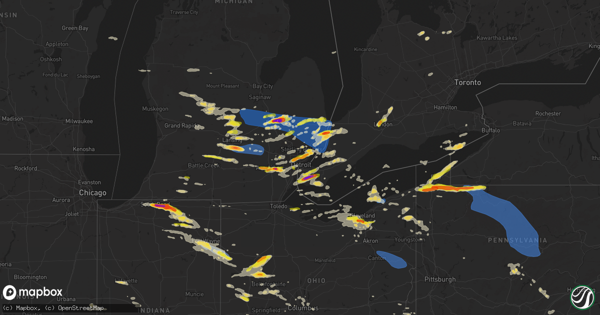
Hail Map on July 20, 2023
Get this storm
July 20 map
$229
one time, instant access
Download today. No call, no setup
Keep the $229
Bought the map and want the full workflow? Apply the entire $229 to a subscription within 7 days. None of it is wasted.
Every map, not just this one
This buys you this map. Subscription and you get every map we run, in the markets you choose from a few cities to whole states to nationwide. Plus real-time alerts the moment a storm fires.
Contact data
Name, contact info, occupancy, even credit band for addresses in the footprint. You go from where it hit to who to call.
Become the source they trust
Unlimited branding weather history reports on demand. You already have the documented answer ready for the property owner, and you are the one who showed up with it.
Property data and RoofTrace estimates
Pull up any address you have got, its value and the exact code rules for that jurisdiction, straight from One Click Code. Then RoofTrace estimates the squares, pitch, and roof value, priced the way you price.
States Impacted by Hail Map on July 20, 2023
Storm reports
Indiana
| Date | Description |
|---|---|
| 07/20/20235:03 PM CDT | 6 inch diameter tree limbs down on covington road and scott road. |
| 07/20/20234:55 PM CDT | 2 inch diameter branches broken off of multiple trees in aboite. |
| 07/20/20234:49 PM CDT | Another very large tree uprooted in sycamore hills neighborhood. Time estimated via radar. |
| 07/20/20234:49 PM CDT | Large tree down in sycamore hills neighborhood in sw fort wayne. Photo on twitter. |
| 07/20/20234:47 PM CDT | Storm chaser livestream shows several large |
| 07/20/20234:47 PM CDT | 2 ft diameter tree broken at base. Time estimated from radar. |
| 07/20/20234:45 PM CDT | 2 8-inch trees down and 1 16-inch tree down on monroeville rd. |
| 07/20/20234:37 PM CDT | Many trees uprooted and otherwise downed in an area between lower huntington rd and covington rd... Bluffton rd and points west. |
| 07/20/20234:22 PM CDT | Powerlines down on springfield center road near boger road in fort wayne. |
| 07/20/20233:48 PM CDT | Tree across coldwater road. Additional trees down in this area. |
| 07/20/20233:33 PM CDT | 12 inch diameter tree down on sr 9 north of albion. |
| 07/20/20233:30 PM CDT | National weather service northern indiana |
| 07/20/20233:21 PM CDT | Report from mping: quarter |
| 07/20/20233:20 PM CDT | Public reports on twitter of quarter size hail in ligonier. Photos on twitter. Time estimated via radar. |
| 07/20/20233:18 PM CDT | Tree down in ligonier. Photos on twitter. Time estimated by radar. |
| 07/20/20233:12 PM CDT | A local report indicates 1.00 inch wind near Millersburg |
| 07/20/20232:52 PM CDT | A local report indicates 1.00 inch wind near 2 E Goshen |
| 07/20/20232:50 PM CDT | Quarter size to slightly larger hail fell at the meijer in dunlap. |
| 07/20/20232:48 PM CDT | A local report indicates 1.50 inch wind near Goshen |
| 07/20/20232:46 PM CDT | A second tree is down on berkey avenue in goshen... Reported by broadcast media on twitter with photo. |
| 07/20/20232:46 PM CDT | Very large tree down on power lines and has downed a power pole. Photo on twitter. |
| 07/20/20232:45 PM CDT | Tree down on s 7th street in goshen. Time estimated by radar. Photo on twitter. |
| 07/20/20232:45 PM CDT | Wind damage to a barn roof in millersburg. Time estimated from radar. |
| 07/20/20232:38 PM CDT | Report from mping: quarter |
| 07/20/20232:32 PM CDT | A local report indicates 1.00 inch wind near 2 NNE Jimtown |
| 07/20/20232:30 PM CDT | Delayed report of 2 inch hail in jimtown. Relayed by broadcast media with photo on twitter. |
| 07/20/20232:30 PM CDT | A local report indicates 1.50 inch wind near Elkhart |
| 07/20/20232:30 PM CDT | A local report indicates 1.50 inch wind near Elkhart |
| 07/20/20232:30 PM CDT | Delayed report. Photo on facebook shows several large hailstones 2+ inches in diameter. Comment with photo says largest hailstone was measured at 2.5 inches. |
| 07/20/20232:20 PM CDT | A local report indicates 1.50 inch wind near Osceola |
| 07/20/20232:18 PM CDT | 2 inch hailstone measured near marion high school in mishawaka... In. |
| 07/20/20232:15 PM CDT | Photos and video on twitter of quarter size hail in mishawaka. |
| 07/20/20232:14 PM CDT | Pictures of large tree limbs down across southern portions of lafayette. Time estimated via radar. |
| 07/20/20232:14 PM CDT | Broadcast media report on twitter of golf ball size hail near the potawatomi zoo. |
| 07/20/20232:11 PM CDT | A local report indicates 1.00 inch wind near South Bend |
| 07/20/20232:10 PM CDT | Broadcast media reports golf ball size hail fell on walnut street. |
| 07/20/20232:10 PM CDT | Spotter reports hail ranging in size from quarters to golf balls. |
| 07/20/20232:05 PM CDT | Spotter reports quarter size hail at twyckenham and madison. |
| 07/20/20232:04 PM CDT | Spotter reports golf ball hail at ironwood and mckinley... In south bend... In. |
Idaho
| Date | Description |
|---|---|
| 07/20/20236:45 PM CDT | Itd rwis itd15 idaho falls. |
| 07/20/20235:20 PM CDT | Mesonet station san sand dunes. |
| 07/20/20235:15 PM CDT | Mesonet station junction 33/22 summit. |
| 07/20/20234:47 PM CDT | Mesonet station crii1 cotton ridge. |
| 07/19/20238:30 PM CDT | Itd rwis itd23 osborne bridge. |
Alabama
| Date | Description |
|---|---|
| 07/20/20236:42 PM CDT | A tree was reported down on a home along monte sano blvd and hutchens ave. |
| 07/20/20234:34 PM CDT | A large tree was reported down along county road 50 near hollywood. |
| 07/19/20238:03 PM CDT | Reports of 1 inch hail in geraldine. |
| 07/19/20238:00 PM CDT | Golf ball size hail was reported in grove oak. |
Virginia
| Date | Description |
|---|---|
| 07/20/20235:37 PM CDT | Tree down. Time estimated from radar. |
Kentucky
| Date | Description |
|---|---|
| 07/20/202311:35 AM CDT | Roof feature blown down. |
| 07/20/202311:06 AM CDT | Tree blown down near i-69 and us 62 interchange at kuttawa. |
| 07/20/202310:55 AM CDT | Estimated wind gust of 60 mph power outages reported. |
| 07/20/202310:31 AM CDT | Tree down on top of vehicle. |
| 07/20/202310:29 AM CDT | Damage reported at the convention center in downtown paducah. |
| 07/20/202310:26 AM CDT | Tree down over the road. |
| 07/20/202310:26 AM CDT | Tree down over the road. |
| 07/20/202310:21 AM CDT | A local report indicates 1.00 inch wind near Bandana |
South Carolina
| Date | Description |
|---|---|
| 07/20/20236:58 PM CDT | Emergency manager reported tree on house on house with person trapped inside. Person removed safely. No injuries. Time estimated by radar. |
| 07/20/20234:05 PM CDT | Scdot reported one tree down on wr simpson road. |
| 07/19/20239:50 PM CDT | Trained spotter measured a wind gust of 62 mph. |
| 07/19/20239:40 PM CDT | Power lines reported down along zion road at wire road. Time estimated from radar. |
| 07/19/20239:40 PM CDT | *** 1 inj *** dorchester county emergency manager reported a downed tree and power lines which fell in the roadway at the intersection of wire rd and zion rd. Two vehic |
| 07/19/20239:35 PM CDT | Tree reported down in the 6600 block of round-o road. Time estimated from radar. |
| 07/19/20239:35 PM CDT | Tree blocking lane near the intersection of round-o road and wesley grove road. Time estimated by radar. |
| 07/19/20239:33 PM CDT | Trees reported down in the 4200 and the 6000 block of charleston highway. Time estimated from radar. |
| 07/19/20239:33 PM CDT | Multiple trees reported down between the 4200 and the 6000 blocks of charleston highway. Time estimated from radar. |
| 07/19/20239:33 PM CDT | Tree reported down along the 22000 block of augusta highway. Time estimated from radar. |
| 07/19/20239:24 PM CDT | Tree reported down along highway 15 at cherry lane. Time estimated from radar. |
| 07/19/20239:17 PM CDT | Trained storm spotter relayed wind damage report through social media with photos. A parking lot light pole at a commercial food distribution center was blown over land |
| 07/19/20239:15 PM CDT | Report of a large limb down along sc-402 at rectory hill road. Time estimated from radar. |
| 07/19/20239:12 PM CDT | Williamsburg call center reported a tree down at rhodus avenue and santee road near andrews... Sc. |
| 07/19/20239:08 PM CDT | Orangeburg county 911 dispatch received report of a tree down across the road in bowman at the intersection of oak st and charleston hwy. Time estimated from radar. |
| 07/19/20239:07 PM CDT | Social media user reported down trees along interstate 26 and some side roads in orangeburg county near bowman. Time estimated. |
| 07/19/20239:06 PM CDT | Scdot reported a tree down on hoghaven road. |
| 07/19/20239:04 PM CDT | Scdot reported a tree down on mcalhany road. |
| 07/19/20239:02 PM CDT | Tree reported down along bells highway at confederate highway. Time estimated from radar. |
| 07/19/20238:59 PM CDT | Scdot reported numerous trees down on langley road. |
| 07/19/20238:54 PM CDT | Scdot reported a tree down on greenwood ave ne. |
| 07/19/20238:52 PM CDT | Scdot reported a tree down on hwy 301 in orangeburg. |
| 07/19/20238:52 PM CDT | Scdot reported numerous trees down on belleville road. |
| 07/19/20238:49 PM CDT | Scdot reported 2 trees down on hillsboro road. |
| 07/19/20238:45 PM CDT | Spotter reported north rd |
| 07/19/20238:39 PM CDT | Orangeburg county dispatch reports 2 trees down across the road near the intersection of sturkie st and bonnette rd. Time estimated from radar. |
| 07/19/20238:18 PM CDT | Barnwell county dispatch reported numerous trees down in the blackville area. Time estimated by radar. |
| 07/19/20238:07 PM CDT | Barnwell county dispatch reported numerous trees down in the williston area. Time estimated by radar. |
| 07/19/20237:42 PM CDT | Aiken dispatch reported widespread trees and powerlines down across the county. Time estimated by radar. |
| 07/19/20237:27 PM CDT | A large tree downed and blocked the road on river north dr. Near gordon hwy. Time estimated by radar. |
| 07/19/20237:25 PM CDT | Edgefield dispatch reported widespread trees and powerlines downed across the county. Time estimated by radar. |
| 07/19/20237:16 PM CDT | Horry county 911 center reported a tree down on william nobles road near aynor... Sc. Call came in around 830 pm... But time of event estimated via radar as 816 pm. |
| 07/19/20237:15 PM CDT | Tree down on bill jones rd |
| 07/19/20237:00 PM CDT | Mccormick county emergency manager reported widespread trees down across the county. |
Missouri
| Date | Description |
|---|---|
| 07/20/20239:06 AM CDT | Trees down... Time estimated from radar. |
| 07/20/20239:06 AM CDT | Trees down... Time estimated from radar. |
| 07/20/20238:59 AM CDT | Trees down. |
| 07/20/20238:36 AM CDT | Split tree. Time estimated from radar. |
| 07/20/20238:30 AM CDT | Tree down just south of belle. 2 other reports of trees down to the south and west. |
New Jersey
| Date | Description |
|---|---|
| 07/20/20236:50 AM CDT | Cr 607 mesonet measured a 54 kt gust. |
| 07/20/20235:59 AM CDT | Report of 1 tree down on portland ave. Time estimated from radar. |
| 07/20/20235:59 AM CDT | Report of 1 tree down on |
Pennsylvania
| Date | Description |
|---|---|
| 07/20/20236:57 PM CDT | Trees down on route 322 |
| 07/20/20236:53 PM CDT | Tree down |
| 07/20/20236:51 PM CDT | Trees and wires down |
| 07/20/20236:48 PM CDT | Trees down in and around sharon |
| 07/20/20236:42 PM CDT | Trees down in and around west salem township. |
| 07/20/20236:40 PM CDT | Multiple trees and wires down in the tidioute area. |
| 07/20/20236:39 PM CDT | Trees down on hatch run rd. |
| 07/20/20236:33 PM CDT | Trees down in and around sandy lake |
| 07/20/20236:29 PM CDT | Wires down on route 426 and chappy rd. |
| 07/20/20236:12 PM CDT | Multiple trees and wires down in the conneautville... Venango... And cambridge springs areas. |
| 07/20/20236:11 PM CDT | Reports of golf ball size hail in sugar grove. |
| 07/20/20235:30 PM CDT | North side of corry... Pa. |
| 07/20/20235:15 PM CDT | Hail damaged some vehicles and also tore off window screens. |
| 07/20/20235:05 PM CDT | A local report indicates 1.00 inch wind near 1 W Union City |
| 07/20/20234:54 PM CDT | A local report indicates 1.50 inch wind near 3 S Mckean |
| 07/20/20234:10 PM CDT | Report from mping: quarter |
| 07/20/202312:46 PM CDT | -delayed report- multiple large trees downed across road 3 miles east of downtown erie. |
| 07/20/202312:43 PM CDT | -delayed report- video and photos of hail approximately the size of half dollars 3 miles east of downtown erie. |
| 07/20/202312:39 PM CDT | Various hail sizes from penny to quarter size. |
| 07/20/202310:35 AM CDT | Multiple reports of trees down across eastern lycoming county. |
| 07/20/20238:33 AM CDT | Multiple trees down reported on clay plant road just outside the town of brockway. |
| 07/20/20232:57 AM CDT | Tree down on pa rt 32. Time estimated from radar. |
| 07/20/20232:46 AM CDT | Large branch down at morris road and west point pike. |
| 07/20/20232:46 AM CDT | Delayed report... Large tree limb across road on rte 313 southbound near ferry road. Time estimated from radar. |
| 07/20/20232:35 AM CDT | Peco reports trees down near the marple crossroads shopping center. Time estimated from radar. |
| 07/20/20232:35 AM CDT | Tree limbs down on wires. Time estimated from radar. |
| 07/20/20232:19 AM CDT | Tree down on us rt 1. Time estimated from radar. |
| 07/20/20232:16 AM CDT | Tree limbs down on wires. Time estimated from radar. |
| 07/20/20232:11 AM CDT | Tree limbs down on wires on bethel church rd. Time estimated from radar. |
| 07/20/20232:02 AM CDT | Tree down on house. |
| 07/20/20231:49 AM CDT | Tree down on cedar hill road. |
| 07/20/20231:46 AM CDT | Tree limbs on wires. Time estimated from radar. |
| 07/20/20231:34 AM CDT | Jcpl reports tree damage on new holland rd. Time estimated from radar. |
| 07/20/20231:16 AM CDT | Tree down on huntzinger road. |
| 07/20/202312:46 AM CDT | Tree fell through a roof. |
| 07/20/202312:39 AM CDT | Tree down on i-83. |
| 07/20/202312:35 AM CDT | 1 tree down on sacramento ct and 1 tree snapped off in a yard. |
| 07/20/202312:29 AM CDT | Corrects previous tstm wnd dmg report from 1 nnw hogestown. Tree down blocking southbound lane of carlisle pike. |
| 07/20/202312:25 AM CDT | Tree down on road. |
| 07/20/202312:13 AM CDT | Trees down. |
| 07/20/202312:13 AM CDT | Tree down on campsite. |
| 07/20/202312:00 AM CDT | Tree down on i-81 blocking the right lane. |
| 07/19/202311:44 PM CDT | Tree down on road. |
| 07/19/202310:35 PM CDT | Multiple reports of trees down across eastern lycoming county. |
| 07/19/202310:10 PM CDT | .75 inch to 1 inch hail fell for 5 minutes during a heavy rain downpour. |
| 07/19/20239:59 PM CDT | Multiple trees down in tyrone. |
| 07/19/20239:57 PM CDT | Multiple trees down in the vicinity of altoona and hollidaysburg. |
| 07/19/20239:55 PM CDT | Trees down on abbott run rd. |
| 07/19/20239:45 PM CDT | Report of power lines down in area. Time estimated based on radar. |
| 07/19/20239:45 PM CDT | Trees on wires behind 1227 isabella street. |
| 07/19/20239:35 PM CDT | Trees and wires down on green mountain rd. |
| 07/19/20239:29 PM CDT | Trees down in mansfield. |
| 07/19/20239:25 PM CDT | Trees down on buffalo run rd near fillmore. |
| 07/19/20239:22 PM CDT | Report of multiple trees down along state route 933 going from trafford to north huntington township. Time estimated based on radar. |
| 07/19/20239:20 PM CDT | Tree down at atherton st and stevenson rd. |
| 07/19/20239:20 PM CDT | Several trees and wires down in the lock haven area. |
| 07/19/20239:12 PM CDT | Wind damage to a 30ft 60ft flat rubber roof striped from the roof structure and 200ft of gutter torn from the structure. |
| 07/19/20238:45 PM CDT | Large tree down across the road at 9582 renovo rd. |
| 07/19/20238:34 PM CDT | Report of trees down in the area. Time estimated based on radar. |
| 07/19/20238:33 PM CDT | Multiple trees down reported on clay plant road just outside the town of brockway. |
| 07/19/20238:33 PM CDT | Tree on wires at 43 good street in clearfield. |
| 07/19/20238:32 PM CDT | Report of a few trees down in the area. Time estimated based on radar. |
| 07/19/20238:17 PM CDT | Multiple trees down in genesee. |
| 07/19/20238:01 PM CDT | Trees on wires in austin... Pa. |
| 07/19/20237:57 PM CDT | Trees across north creek rd. |
| 07/19/20237:55 PM CDT | Multiple trees down in penfield... Including one on a house. |
| 07/19/20237:54 PM CDT | Report of trees down in franklin township. Time estimated based on radar. |
| 07/19/20237:48 PM CDT | Report of downed tree on southbound lane of route 8. Time estimated based on radar. |
| 07/19/20237:45 PM CDT | Trees down on route 155 near two mile rd. |
| 07/19/20237:44 PM CDT | Report of trees and power lines down in the area. Time estimated based on radar. |
| 07/19/20237:40 PM CDT | Report of trees and power lines down in the area. Time estimated based on radar. |
| 07/19/20237:34 PM CDT | Multiple reports of trees and wires down along us 6 near smethport. |
| 07/19/20237:32 PM CDT | Report of trees and power lines down in the area. Time estimated based on radar. |
| 07/19/20237:32 PM CDT | Report of trees down in the area. Time estimated based on radar. |
| 07/19/20237:29 PM CDT | Trees and wires down on old red mill dam rd. |
| 07/19/20237:27 PM CDT | Trees and wires down on silver creek rd. |
| 07/19/20237:24 PM CDT | Report of multiple trees and power lines down in area. Time estimated based on radar. |
| 07/19/20237:24 PM CDT | Report of tree down in area. Time estimated based on radar. |
| 07/19/20237:24 PM CDT | Trees down |
| 07/19/20237:23 PM CDT | Trees down |
| 07/19/20237:22 PM CDT | Report of tree down in area. Time estimated based on radar. |
| 07/19/20237:22 PM CDT | Report of multiple trees and power lines down in area. Time estimated based on radar. |
| 07/19/20237:22 PM CDT | *** 1 inj *** report of tree down on vehicle with only minor injury noted for inhabitant. Time estimated based on radar |
| 07/19/20237:22 PM CDT | *** 1 inj *** report of tree down on vehicle with only minor injury noted for inhabitant. Time estimated based on radar |
| 07/19/20237:21 PM CDT | Report of tree down on greenwood road in barnett township. Time estimated based on radar. |
| 07/19/20237:20 PM CDT | Report of tree down on greenwood road. Time estimated based on radar. |
| 07/19/20237:19 PM CDT | Reports of numerous trees and powerlines downs in pine township. |
| 07/19/20237:18 PM CDT | Report of numerous trees and powerlines down around grove city. Time estimated based on radar. |
| 07/19/20237:18 PM CDT | Report of tree down blocking westbound lane near country farm supply. Time estimated based on radar. |
| 07/19/20237:15 PM CDT | Trees down in lewis run borough. |
| 07/19/20237:04 PM CDT | Report of tree down on job corps road in jenks township. Time estimated based on radar. |
West Virginia
| Date | Description |
|---|---|
| 07/20/202312:49 AM CDT | Trees blew down on wv-259 carpers pike near turnbuckle drive... And in the 2000 block of cr-50/25 dillons run road. |
| 07/20/202312:40 AM CDT | Trees blew down along wv-28 cumberland road in the 4000 block. |
| 07/20/202312:25 AM CDT | Several trees blew down in the keyser and new creek area... Including on us-50 northwestern turnpike near wv-93 laurel dale road and us-220 cut off road... And on cr-16 |
| 07/19/202311:50 PM CDT | A few trees down along route 72 north of rowlesburg. |
Tennessee
| Date | Description |
|---|---|
| 07/20/20233:05 PM CDT | County dispatch reported numerous trees and powerlines down across the county. Mentioned that the worst area seemed to be around signal mountain. Time estimated by rada |
| 07/20/20232:46 PM CDT | Dispatch reported numerous trees and powerlines down across the county. Time estimated by radar. |
| 07/20/20232:45 PM CDT | Corrects time of previous tstm wnd dmg report from 3 ne tullahoma. Trees down with multiple power outages in the short springs/ovoca area. Time is radar estimated. |
| 07/20/20232:43 PM CDT | Twitter photos received of the roof blown off of life style staffing office as well as a large tree blown down in the parking lot. Time is radar estimated. |
| 07/20/20232:42 PM CDT | Photo received via twitter of large tree down off of anthony lane in shelbyville. Time is radar estimated. |
| 07/20/20232:42 PM CDT | Photo received via twitter of quarter size hail at titan transfer off of stanley blvd. Time estimated on radar. |
| 07/20/20232:42 PM CDT | Photo received via twitter of large tree down off of anthony lane in shelbyvilger reports numerous trees down between wren... Oh and ohio city... Oh. |
| 07/20/20232:38 PM CDT | Multiple photos received of barn destroyed... Large tree uprooted... And smaller trees blown down along mcclain road. Time estimated on radar. |
| 07/20/20232:35 PM CDT | Roads flooded in the flat creek area. |
| 07/20/20232:30 PM CDT | Tree down on vehicle on cedar lane. |
| 07/20/20232:29 PM CDT | Trees down with multiple power outages in the short springs/ovoca area. Time is radar estimated. |
| 07/20/20232:25 PM CDT | Photo received via facebook of a shed blown down off of shelbyville rd. Near trousdale church. Time is radar estimated. |
| 07/20/20232:21 PM CDT | Photo received via facebook of roof torn off of meeks tire co. Time is radar estimated. |
| 07/20/20232:17 PM CDT | Photo received via twitter of a large pine tree down in centertown off of hwy 70-south near the warren/cannon county line. Time is radar estimated. |
| 07/20/20232:15 PM CDT | Dispatch reported tree down near patty road. |
| 07/20/20232:05 PM CDT | Tree down and outbuilding damaged on old kentucky rd near central view market. |
| 07/20/20232:00 PM CDT | 20 trees snapped on buckner rd at mt view ln. |
| 07/20/20231:58 PM CDT | Twitter video showed large tree blown down on midway road near terrell road. Other scattered trees and power lines reported down across the county. |
| 07/20/20231:57 PM CDT | 10 inch diameter pine tree snapped on hwy 70 near the cannon and warren county line. |
| 07/20/20231:55 PM CDT | Corrects previous tstm wnd dmg report from 3 ne tullahoma. Trees down and power poles snapped with multiple power outages in the short springs/ovoca area. Time is radar |
| 07/20/20231:53 PM CDT | Trees down on red hill rd. |
| 07/20/20231:52 PM CDT | Carport destroyed and mini barn flipped over on hwy 53 at simpson road. |
| 07/20/20231:48 PM CDT | Photo received via twitter of tree uprooted on sunny slope rd. Near woodbury. Time is radar estimated. |
| 07/20/20231:42 PM CDT | Photo received via twitter of tree down on bradyville road. Time is radar estimated. |
| 07/20/20231:33 PM CDT | Large tree down blocking cranor road. |
| 07/20/20231:33 PM CDT | Large tree down blocking cranor road. |
| 07/20/20231:30 PM CDT | Trees down and dugout damaged in lascassas. |
| 07/20/20231:27 PM CDT | Dispatch reported trees down throughout county. Time estimated from radar. |
| 07/20/20231:25 PM CDT | Tspotter photo of large tree down blocking hwy 100 at old harding pike. |
| 07/20/20231:20 PM CDT | Photo received via facebook of large tree that went through roof of home off of lakeshore drive in old hickory. Time is radar estimated. |
| 07/20/20231:12 PM CDT | Nws employee estimated 70-80 mph winds in mount juliet. |
| 07/20/20231:12 PM CDT | Photo received via twitter of a large tree down at a home off of vanderbilt rd. Time is radar estimated. |
| 07/20/20231:10 PM CDT | Photo received via facebook of a large tree snapped in half at a home off of n greenhill rd. Near needmore rd. Time is radar estimated. |
| 07/20/20231:10 PM CDT | Trees and power lines down across mount juliet. |
| 07/20/20231:10 PM CDT | Trees and power lines down across mount juliet. Homes across cherokee county. |
| 07/20/20231:01 PM CDT | Photo received via facebook of a large tree down on powerlines blocking a portion of shirley drive. Time is radar estimated. |
| 07/20/20231:01 PM CDT | Several trees down along vanderbilt rd. |
| 07/20/20231:00 PM CDT | Social media photos of numerous trees down around gallatin with some blocking roads. |
| 07/20/202312:55 PM CDT | Numerous trees and power lines down across southwestern sumner county. One tree fell onto and crushed a house on raintree dr. |
| 07/20/202312:54 PM CDT | Numerous trees and power lines down in the greenbrier and ridgetop areas. |
| 07/20/202312:51 PM CDT | Power lines down and large power poles leaning near rivergate mall. |
| 07/20/202312:50 PM CDT | Dispatch reported trees down throughout county. Time estimated from radar. |
| 07/20/202312:48 PM CDT | Trees and power lines coming down all over the place. |
| 07/20/202312:45 PM CDT | Dispatch reported trees down throughout the county. Time estimated from radar. |
| 07/20/202312:45 PM CDT | Corrects time of previous tstm wnd dmg report from 1 ne ridgetop. Photos received of large tree down near home as well as shutters blown off into the bushes on lake rd. |
| 07/20/202312:40 PM CDT | Dispatch call center reported trees down throughout the county. Time estimated from radar. |
| 07/20/202312:34 PM CDT | Multiple homes with trees down on the roof and power lines down all across the 2500 block of kelly willis road. Time is radar estimated. |
| 07/20/202312:34 PM CDT | Trees and power lines down throughout robertson county with many across roads. |
| 07/20/202312:32 PM CDT | Two trees down on kinneys rd.... One at airport rd. Junction and the other at justice rd. Junction. |
| 07/20/202312:21 PM CDT | Photo and report received via facebook of a large tree uprooted with notable tree damage along charles bell road and hartley drive. Time is radar estimated. |
| 07/20/202312:20 PM CDT | Photos received of large tree down near home as well as shutters blown off into the bushes on lake rd. In greenbrier. Time is radar estimated. |
| 07/20/202312:20 PM CDT | Numerous trees and power lines down across the county... Especially northeastern areas. |
Maryland
| Date | Description |
|---|---|
| 07/20/20234:37 AM CDT | Tree down at unionville road and st. Michaels road. |
| 07/20/20233:29 AM CDT | Large tree limb down on powerlines across the road on the 2000 block of south haven road |
| 07/20/20233:10 AM CDT | Delayed report. Harford county fire/ems reported that one individual was trapped on their rear deck after a large tree fell onto a home along north kelly ave in bel air |
| 07/20/20231:09 AM CDT | Several trees blew down in the eldersburg/sykesville area... Including on emerald lane... Cherry tree road... And nicodemus road. |
| 07/20/20231:02 AM CDT | Several trees blew down in the hampstead area... Including along carrollton road. |
| 07/20/20231:00 AM CDT | Several trees blew down in the brunswick area... Including along md-464 souder road/point of rocks road near north maple avenue and catoctin mountain highway. |
| 07/20/202312:55 AM CDT | Several trees blew down between libertytown and new market. |
| 07/20/202312:21 AM CDT | Trees blew down in the thurmont area. |
New York
| Date | Description |
|---|---|
| 07/20/20236:59 PM CDT | Power poles broken and 3-inch tree limbs broken. |
| 07/20/20236:58 PM CDT | Tree down across route 353. |
| 07/20/20236:58 PM CDT | Tree down on gowanda zoar road. |
| 07/20/20236:57 PM CDT | Tree down across broadway road. |
| 07/20/20236:55 PM CDT | Tree down on belknap rd in eden. |
| 07/20/20236:54 PM CDT | Tree down across the intersection of nelson & beebe roads in wilson. |
| 07/20/20236:46 PM CDT | Tree down in youngstown on vehicle and home. |
| 07/20/20236:46 PM CDT | Reports of multiple trees down in the town of evans. |
| 07/20/20236:46 PM CDT | Tree down on home on lake shore road in the town of evans. |
| 07/20/20236:44 PM CDT | Tree down in perrysburg. |
| 07/20/20236:43 PM CDT | Tree down on a house and car. |
| 07/20/20236:43 PM CDT | Reports of multiple trees down in angola. |
| 07/20/20236:41 PM CDT | Tree down on markhams road. |
| 07/20/20236:40 PM CDT | Several trees down in dayton. |
| 07/20/20236:38 PM CDT | Several trees and wires down across town in south dayton. |
| 07/20/20236:37 PM CDT | Reports of multiple trees down in brant. |
| 07/20/20236:37 PM CDT | Reports of multiple trees down in farnham. |
| 07/20/20236:35 PM CDT | Tree down blocking both directions of bates road. |
| 07/20/20236:35 PM CDT | Large tree and wires down on maple ave. |
| 07/20/20236:26 PM CDT | Large tree down across lake avenue. Additional trees down on lake avenue. |
| 07/20/20236:26 PM CDT | Tree down onto house on west shorewood drive. |
| 07/20/20236:25 PM CDT | Tree and wires down on cassadaga road. |
| 07/20/20236:25 PM CDT | Several trees down near route 5 and lake avenue. |
| 07/20/20236:24 PM CDT | Tree down on parcell road. |
| 07/20/20236:17 PM CDT | Large tree down across academy street. |
| 07/20/20236:17 PM CDT | Tree and wires down on park street. |
| 07/20/20236:16 PM CDT | Tree down on union street. |
| 07/20/20236:12 PM CDT | Tree and wires down in hartfield. |
| 07/20/20236:11 PM CDT | Telephone pole down across route 20. |
| 07/19/20239:05 PM CDT | Power lines down. |
| 07/19/20239:00 PM CDT | Wires down in campbell... Ny. |
| 07/19/20238:43 PM CDT | Trees down near county rt 14 in bath... Ny. |
| 07/19/20238:40 PM CDT | Tree down on golf ave near marsh rd intersection. |
| 07/19/20238:39 PM CDT | Tree down. |
| 07/19/20238:28 PM CDT | Tree down crossing manitou rd and shepard rd intersection. |
| 07/19/20238:18 PM CDT | Power lines down in the village of avon... Including at north ave. And main st. |
| 07/19/20238:11 PM CDT | Trees down reported near i-86 and county rte 21. |
| 07/19/20238:09 PM CDT | Trees down partially blocking county rt 70a in north hornell. |
| 07/19/20237:46 PM CDT | Tree down in alexander. |
| 07/19/20237:34 PM CDT | Tree down on route 446. |
| 07/19/20237:33 PM CDT | Tree down across olean portville road. |
| 07/19/20237:28 PM CDT | Trees down in the town of eagle. |
| 07/19/20237:26 PM CDT | Multiple trees down on 4 mile road. |
| 07/19/20237:20 PM CDT | Trees down. |
| 07/19/20237:19 PM CDT | Tree down in the village of franklinville. |
| 07/19/20237:15 PM CDT | Tree down across delevan road |
| 07/19/20237:15 PM CDT | Several trees down. |
| 07/19/20237:13 PM CDT | Tree down on maple street in yorkshire. |
| 07/19/20237:08 PM CDT | Tree down at mile marker 61.3 blocking traffic on i-86 just east of salamanca. |
| 07/19/20237:07 PM CDT | Tree down on doat street near poplar ave. |
| 07/19/20237:00 PM CDT | Tree down across reed hill road. |
Oklahoma
| Date | Description |
|---|---|
| 07/20/20235:30 AM CDT | A local report indicates 68 MPH wind near 8 E Newkirk |
| 07/20/20234:10 AM CDT | A local report indicates 58 MPH wind near 3 SE Breckenridge |
| 07/20/20234:05 AM CDT | Train cars overturned... Power poles down. |
| 07/20/20233:52 AM CDT | A local report indicates 74 MPH wind near Vance Air Force Base |
| 07/20/20233:45 AM CDT | A local report indicates 84 MPH wind near Vance Air Force Base |
| 07/20/202312:50 AM CDT | Measured by oklahoma mesonet. |
| 07/20/202312:35 AM CDT | Measured by oklahoma mesonet. |
| 07/20/202312:34 AM CDT | Mobile home sustained roof damage. Pictures sent in from emergency manager. Time estimated from radar. |
Illinois
| Date | Description |
|---|---|
| 07/20/20233:05 PM CDT | Social media report. Time estimated from radar. |
| 07/20/20232:05 PM CDT | Corrects time of previous hail report from trilla. Social media report. Time estimated from radar. |
| 07/20/202311:12 AM CDT | Power lines down... Time estimated from radar. |
| 07/20/202310:21 AM CDT | Trees and powerlines down blocking road. |
| 07/20/202310:21 AM CDT | Trees and powerlines down blocking road. Le. Time is radar estimated. |
| 07/20/202310:21 AM CDT | Tree and powerline down over the road. |
| 07/20/202310:21 AM CDT | Reports of trees and powerlines down. |
| 07/20/202310:21 AM CDT | Trees down over road. |
| 07/20/202310:21 AM CDT | Trees and powerlines down. |
| 07/20/202310:09 AM CDT | Multiple 2 to 3 ft in diameter trees down across roads and powerlines. |
| 07/20/202310:03 AM CDT | 8 inch tree limbs down... Time estimated from radar. |
Colorado
| Date | Description |
|---|---|
| 07/20/20235:48 PM CDT | A local report indicates 1.00 inch wind near 2 NNE Olney Springs |
| 07/20/20235:45 PM CDT | A local report indicates 1.00 inch wind near 4 SSE Manzanola |
| 07/20/20235:42 PM CDT | Relayed via social media. |
| 07/20/20235:37 PM CDT | Report from mping: ping pong ball |
| 07/20/20235:30 PM CDT | Report from mping: half dollar |
| 07/20/20235:29 PM CDT | Report from mping: quarter |
| 07/20/20235:23 PM CDT | Windows broken at house. |
| 07/20/20235:17 PM CDT | Report from mping: quarter |
| 07/20/20235:17 PM CDT | A local report indicates 1.25 inch wind near 4 E Canon City |
| 07/20/20235:11 PM CDT | Report from mping: quarter |
| 07/20/20235:10 PM CDT | Report from mping: quarter |
| 07/20/20234:56 PM CDT | A local report indicates 1.25 inch wind near 5 SSE Truckton |
| 07/20/20234:52 PM CDT | Report from mping: quarter |
| 07/20/20234:45 PM CDT | 2.25 inch hail. |
| 07/20/20234:43 PM CDT | A local report indicates 1.75 inch wind near Simla |
| 07/20/20234:25 PM CDT | Quarter size hail. Wind driven more than 50 mph. One vehicle lost their back window and both side mirrors... Exterior light glass broken. |
| 07/20/20234:24 PM CDT | A local report indicates 1.75 inch wind near Simla |
| 07/20/20234:15 PM CDT | Mesonet station ew7240 7 wnw simla. |
| 07/20/20234:12 PM CDT | Time estimated by radar. |
| 07/20/20233:50 PM CDT | A local report indicates 1.75 inch wind near 4 E Kiowa |
| 07/20/20233:45 PM CDT | A local report indicates 1.50 inch wind near Peterson AFB |
| 07/20/20233:43 PM CDT | Report from mping: half dollar |
| 07/20/20233:38 PM CDT | Report from mping: ping pong ball |
| 07/20/20233:37 PM CDT | A local report indicates 1.00 inch wind near 2 NW Peterson AFB |
| 07/20/20233:35 PM CDT | Report from mping: quarter |
| 07/20/20233:28 PM CDT | A local report indicates 2.50 inch wind near 3 N Colorado Springs |
| 07/20/20233:26 PM CDT | A local report indicates 1.00 inch wind near 2 NNE Colorado Springs |
| 07/20/20233:25 PM CDT | At colorado college. |
| 07/20/20233:25 PM CDT | A local report indicates 1.25 inch wind near 2 NW Colorado Springs |
| 07/20/20233:24 PM CDT | Report from mping: golf ball |
| 07/20/20233:19 PM CDT | A local report indicates 1.50 inch wind near 1 NNW Manitou Springs |
| 07/20/20233:14 PM CDT | A local report indicates 1.00 inch wind near 5 NE Manitou Springs |
| 07/20/20233:13 PM CDT | Spotter: e561. |
| 07/20/20233:10 PM CDT | A local report indicates 1.00 inch wind near 1 NE Ponderosa Park |
| 07/20/20233:09 PM CDT | Mesonet station gw2494 elizabeth. |
| 07/20/20233:08 PM CDT | Report from mping: quarter |
| 07/20/20232:48 PM CDT | A local report indicates 1.00 inch wind near Divide |
| 07/19/20237:18 PM CDT | A local report indicates 70 MPH wind near 2 NNE Las Animas |
| 07/19/20237:09 PM CDT | Report from mping: quarter |
Ohio
| Date | Description |
|---|---|
| 07/20/20236:58 PM CDT | Tree down on boneta rd between route 18 and ridgewood. |
| 07/20/20236:55 PM CDT | Tree down. Time estimated from radar. |
| 07/20/20236:54 PM CDT | Multiple trees down. Time estimated from radar. |
| 07/20/20236:50 PM CDT | Tree down onto park ledge drive. |
| 07/20/20236:50 PM CDT | Reports of several trees down across howland township. |
| 07/20/20236:50 PM CDT | Tree downed onto road in brunswick. Time estimated via radar. |
| 07/20/20236:49 PM CDT | . |
| 07/20/20236:49 PM CDT | Two trees downed across road near bloomville. Time estimated via radar. |
| 07/20/20236:49 PM CDT | A local report indicates 1.00 inch wind near 1 ESE Parma |
| 07/20/20236:45 PM CDT | Report from mping: ping pong ball |
| 07/20/20236:41 PM CDT | A few downed trees and power outages reported in the new london area. Time estimated via radar. |
| 07/20/20236:40 PM CDT | Report from mping: half dollar |
| 07/20/20236:40 PM CDT | Corrects previous hail report from 1 ese parma. |
| 07/20/20236:34 PM CDT | Large section of tree downed on n center street. One power pole broken. Time estimated from radar. |
| 07/20/20236:27 PM CDT | Trees and power lines down. Time estimated from radar. |
| 07/20/20236:27 PM CDT | Tree downed. Time estimated via radar. |
| 07/20/20236:26 PM CDT | Nickel to quarter sized hail at nws cleveland office. |
| 07/20/20236:25 PM CDT | 1.5 inch hail. |
| 07/20/20236:22 PM CDT | Large tree limb down 4 miles northwest of mantua. Time estimated via radar. |
| 07/20/20236:20 PM CDT | Retired nws employee reports 1 and a half inch hail in parma. |
| 07/20/20236:20 PM CDT | Large tree branch on west 54th. |
| 07/20/20236:18 PM CDT | Quarter to golf ball-sized hail in parma and parma heights. |
| 07/20/20236:11 PM CDT | Large tree branch snapped at lakewood park. |
| 07/20/20236:05 PM CDT | Report from mping: quarter |
| 07/20/20236:05 PM CDT | A local report indicates 2.00 inch wind near Westlake |
| 07/20/20236:05 PM CDT | Two trees down in north olmsted. |
| 07/20/20236:04 PM CDT | Report from mping: quarter |
| 07/20/20236:00 PM CDT | Report forwarded via social media. |
| 07/20/20235:57 PM CDT | Report from mping: quarter |
| 07/20/20235:56 PM CDT | A local report indicates 1.00 inch wind near Avon |
| 07/20/20235:54 PM CDT | Social media photo of measured hail stones. |
| 07/20/20235:52 PM CDT | Two trees down on a house. Time estimated from radar. |
| 07/20/20235:50 PM CDT | Report from mping: quarter |
| 07/20/20235:46 PM CDT | A few tree limbs down on jefferson street. |
| 07/20/20235:45 PM CDT | Emergency manaille cattaraugus ny 4234 7845 tree down in the village of franklinville. |
| 07/20/20235:45 PM CDT | Emergency manager reports numerous trees down between wren... Oh and ohio city... Oh. |
| 07/20/20235:43 PM CDT | Tree down on north main street in rockford. |
| 07/20/20235:42 PM CDT | Large branch down. Time estimated from radar. |
| 07/20/20235:40 PM CDT | Tree down on house on auburn rd. |
| 07/20/20235:39 PM CDT | Trees down. Time estimated from radar. |
| 07/20/20235:33 PM CDT | Report from mping: half dollar |
| 07/20/20235:32 PM CDT | -delayed report- multiple large limbs and trees down in conneaut... Some onto roadways. |
| 07/20/20235:31 PM CDT | Tree down on house. Time estimated from radar. |
| 07/20/20235:30 PM CDT | A local report indicates 1.25 inch wind near Harrod |
| 07/20/20235:30 PM CDT | Trees down. Time estimated from radar. |
| 07/20/20235:30 PM CDT | Buoy station faio1 fairport... Oh. |
| 07/20/20235:28 PM CDT | -delayed report- tree limbs downed in painesville. |
| 07/20/20235:27 PM CDT | Widespread tree damage in fairport harbor. Time estimated via radar. |
| 07/20/20235:27 PM CDT | -delayed report- siding partially peeled off the second story of a house in fairport harbor. |
| 07/20/20235:24 PM CDT | Emergency manager reports tree down on a house in ohio city in van wert county. One person injured and trapped. Also powerlines down in ohio city as well. |
| 07/20/20235:24 PM CDT | *** 1 fatal *** corrects previous tstm wnd dmg report from ohio city. 1 fatality confirmed. Second occupant not injured. Emergency manager reports tree down on an overh |
| 07/20/20235:24 PM CDT | Corrects previous tstm wnd dmg report from ohio city to update number of injuries. Emergency manager reports tree down on a house in ohio city in van wert county. Two p |
| 07/20/20235:18 PM CDT | Asos station ktdz toledo. |
| 07/20/20235:18 PM CDT | Power pole snapped and hit a car... Large tree branch on wires near the yacht club and large tree uprooted. |
| 07/20/20235:18 PM CDT | Buoy station faio1 fairport... Oh. |
| 07/20/20235:18 PM CDT | -delayed report- two pictures received on social media of a tree and large limb downed on cars in separate residential driveways in mentor. |
| 07/20/20235:17 PM CDT | -delayed report- numerous reports from a retired nws employee... Broadcast meteorologist... And the public of widespread... Extensive tree and power-line damage in ment |
| 07/20/20235:17 PM CDT | Tree limb and power line downed. Time estimated via radar. |
| 07/20/20235:05 PM CDT | Trees down. Time estimated from radar. |
| 07/20/20234:40 PM CDT | Report from mping: half dollar |
| 07/20/20234:39 PM CDT | Report from mping: quarter |
| 07/20/20234:07 PM CDT | Large tree down in kunkle. Time estimated via radar. |
| 07/20/20233:57 PM CDT | Report from mping: half dollar |
| 07/19/20239:18 PM CDT | 2 trees down. Time estimated from radar. |
| 07/19/20239:04 PM CDT | Tree down. Time estimated from radar. |
| 07/19/20238:55 PM CDT | One large tree downed on w main street. Time estimated from radar. |
| 07/19/20238:45 PM CDT | Tree down on annesley road. |
| 07/19/20238:41 PM CDT | Numerous branches on atioch road... Trees down. Time estimated from radar. |
| 07/19/20238:41 PM CDT | Trees down. Time estimated from radar. |
| 07/19/20238:39 PM CDT | Tree down. |
| 07/19/20238:38 PM CDT | Roof damage to a barn. |
| 07/19/20238:38 PM CDT | Tree down on state route 164 and spring valley road. |
| 07/19/20238:38 PM CDT | Tree down. |
| 07/19/20238:30 PM CDT | Numerous trees down along old state route 73. |
| 07/19/20238:26 PM CDT | Trees and wires down. Time estimated from radar. |
| 07/19/20238:25 PM CDT | A local report indicates 71 MPH wind near 2 ESE Wilmington |
| 07/19/20238:25 PM CDT | Tree down on route 45 and route 558. |
| 07/19/20238:24 PM CDT | Tree down on gamble road. |
| 07/19/20238:12 PM CDT | Large branch down. Time estimated from radar. |
| 07/19/20238:09 PM CDT | Trees down on power lines. Time estimated from radar. |
| 07/19/20238:07 PM CDT | Trees down. Time estimated from radar. |
| 07/19/20238:02 PM CDT | Fallen tree onto roof of house. |
| 07/19/20238:00 PM CDT | Scattered tree damage across knox county... Especially western and southwestern portions of the county. Time estimated via radar. |
| 07/19/20237:58 PM CDT | Large branch and wires down near fisher and hague roads. Time estimated from radar. |
| 07/19/20237:47 PM CDT | Trees down and telephone poles snapped. Time estimated from radar. |
| 07/19/20237:40 PM CDT | Numerous large tree limbs down - time estimated from radar. |
| 07/19/20237:40 PM CDT | Several trees down and blocking roads in new franklin. |
| 07/19/20237:38 PM CDT | Tree limb downed onto road in the mechanicsburg/wayne twp area. A few other wires reported downed in the county. Time estimated via radar. |
| 07/19/20237:38 PM CDT | Trees down along u.s. 23 in delaware. |
| 07/19/20237:21 PM CDT | Three cars submerged in water at w117 and berea rd. |
| 07/19/20237:10 PM CDT | Numerous branches down - time estimated by radar. |
| 07/19/20237:10 PM CDT | Large red oak tree snapped 15-20 ft up and fell on house. |
| 07/19/20237:08 PM CDT | Trees down countywide. Time estimated from radar. |
| 07/19/20237:07 PM CDT | A few trees and wires downed onto roadways between nova and nankin. Time estimated via radar. |
| 07/19/20237:07 PM CDT | A few trees and wires downed onto roadways between nova and nankin. Time estimated via radar. |
| 07/19/20237:02 PM CDT | Tree down on yellow creek rd near sand run rd. |
| 07/19/20237:00 PM CDT | Several trees/wires down across liberty township. |
Kansas
| Date | Description |
|---|---|
| 07/20/20236:26 PM CDT | Asos station kddc dodge city regional airport. |
| 07/20/20236:05 PM CDT | A local report indicates 70 MPH wind near 2 NW Dodge City |
| 07/20/20235:36 PM CDT | Report from mping: half dollar |
| 07/20/20235:25 PM CDT | A local report indicates 60 MPH wind near 6 N Ingalls |
| 07/20/20235:00 PM CDT | Asos station kgck garden city. |
| 07/20/20234:48 PM CDT | A local report indicates 2.50 inch wind near 10 NE Garden City |
| 07/20/20234:30 PM CDT | A local report indicates 1.00 inch wind near 4 W Lydia |
| 07/20/20234:20 PM CDT | A home lost some shingles and some flying debris struck a propane tank causing a gas leak. |
| 07/20/20234:15 PM CDT | Picture of flipped center pivot at this location on gano rd... About a mile east of highway 83 where power poles were down. There was extensive wind and hail damage to |
| 07/20/20234:15 PM CDT | Several power poles down at this location. Image of this damage also showed hail-covered field with hail fog. |
| 07/20/20234:10 PM CDT | A dozen power poles down around the intersection of kansas rd and finney scott rd due to possible tornado. |
| 07/20/20233:45 PM CDT | Facebook messenger. |
| 07/20/20233:43 PM CDT | A local report indicates 2.50 inch wind near 2 WNW Modoc |
| 07/20/20233:00 PM CDT | Reports of damage to irrigation equipment and sheds. |
| 07/20/20233:00 PM CDT | Window damage to home also reported. |
| 07/20/202312:55 AM CDT | Mesonet station up835 3.0 w kingsdown |
| 07/20/202312:45 AM CDT | Mesonet station dw9907 bloom. |
| 07/20/202312:31 AM CDT | Awos station klbl liberal. |
| 07/20/202312:25 AM CDT | A local report indicates 70 MPH wind near Liberal |
| 07/20/202312:20 AM CDT | Delayed report of railroad crossing arm broken off at main street in tribune. |
| 07/19/202311:55 PM CDT | Awos station khqg hugoton. |
| 07/19/202311:15 PM CDT | Mesonet station lkuk1 lakin. |
| 07/19/202310:25 PM CDT | Corrects previous tstm wnd dmg report from tribune. Delayed report of railroad crossing arm broken off at main street in tribune. Time is estimated using radar and near |
| 07/19/202310:22 PM CDT | The awos in tribune |
| 07/19/202310:18 PM CDT | A local report indicates 58 MPH wind near 6 E Tribune |
| 07/19/202310:14 PM CDT | A local report indicates 69 MPH wind near 5 S Tribune |
| 07/19/202310:11 PM CDT | Tribune awos reported at wind gust of 64 mph at 911 pm mdt. |
| 07/19/20239:40 PM CDT | Mesonet station kwlk1 wallace. Wind gust measured at 2 meter height. Wind direction from the north-northeast. |
Georgia
| Date | Description |
|---|---|
| 07/20/20236:59 PM CDT | Corrects previous tstm wnd dmg report from norwood. Trees down in the 1000-4000 blocks of ridge road in norwood. |
| 07/20/20236:59 PM CDT | Emergency manager reported a tree in the road at 6212 holloway rd. Time estimated by radar. |
| 07/20/20236:57 PM CDT | Lincoln co em reported multiple trees down in elijah state park. Time estimated. |
| 07/20/20236:53 PM CDT | Multiple trees down along highway 78 from near arnoldsville to the clarke county line. |
| 07/20/20236:48 PM CDT | Lincoln county emergency manager reported around a dozen trees down within a 2 mile radius of lincolnton. Time estimated by radar. |
| 07/20/20236:45 PM CDT | Lincoln county emergency manager reported trees down in lincolnton. Time estimated by radar. |
| 07/20/20236:38 PM CDT | Lincoln co em reported two homes with trees fallen into roof near broad river. Time estimated. |
| 07/20/20236:38 PM CDT | Corrects previous tstm wnd dmg report from 15 nnw lincolnton. Lincoln co em reported two homes with trees fallen into roof near broad river scenic drive. Time estimated |
| 07/20/20236:36 PM CDT | Multiple trees were downed along upper mill road. |
| 07/20/20236:36 PM CDT | Multiple trees downed in the town of sharon with widespread power outages. |
| 07/20/20236:30 PM CDT | Awos station kiiy washington. |
| 07/20/20236:30 PM CDT | Multiple trees were blown down along silas mercer road. |
| 07/20/20236:25 PM CDT | Multiple trees were downed in the springfield community. |
| 07/20/20236:20 PM CDT | Utility lines were downed in the 1000 block of west college street. |
| 07/20/20236:20 PM CDT | A tree was downed in the 1800 block of high falls road. |
| 07/20/20236:20 PM CDT | A tree was downed on old mount zion road. |
| 07/20/20236:20 PM CDT | A tree was downed on the 1300 block of ellis road. |
| 07/20/20236:16 PM CDT | Reports of 22 trees down and power outages across henry county. |
| 07/20/20236:15 PM CDT | A tree was downed in the 300 block of bendview road. |
| 07/20/20236:00 PM CDT | Photo of a large tree down in the roadway along main st in winterville... Ga. |
| 07/20/20235:56 PM CDT | Reports of widespread down trees across murray county. |
| 07/20/20235:55 PM CDT | Large tree down on a structure along cedar shoals dr. |
| 07/20/20235:55 PM CDT | Multiple large pine trees toppled at the intersection of lexington rd and the loop. |
| 07/20/20235:55 PM CDT | Photo of a large tree down on a car along barrentt shoals rd. |
| 07/20/20235:54 PM CDT | Asos station kahn athens. |
| 07/20/20235:53 PM CDT | Corrects previous tstm wnd dmg report from 3 nw ola. Reports of 22 trees down and power outages across henry county. |
| 07/20/20235:50 PM CDT | Downed powerlines near the intersection of austin bridge rd and lester rd. |
| 07/20/20235:50 PM CDT | Mesonet station 0761w 0.6 se athens |
| 07/20/20235:50 PM CDT | Photo from emergency management showing multiple large trees down in forest heights. |
| 07/20/20235:46 PM CDT | The red cross reported a tree on a house on wabash lane. |
| 07/20/20235:45 PM CDT | Numerous reports of wind damage on the uga campus... Including damage to gutters... Awnings... Shingles and windows. Trees and power lines were also down in multiple lo |
| 07/20/20235:45 PM CDT | One tree down along thurman baccus road. |
| 07/20/20235:45 PM CDT | A uga weather stem station located at 100 sanford drive measured a 66 mph wind gust. |
| 07/20/20235:45 PM CDT | At least 23 reports of trees down across jackson county. |
| 07/20/20235:45 PM CDT | Powerlines down in the roadway near the intersection of cedar creek dr and villa rica hwy. |
| 07/20/20235:45 PM CDT | The red cross reported a tree down on gresham avenue se. |
| 07/20/20235:42 PM CDT | Utility lines were downed at the intersection of chapel hill rd and forest view trail. |
| 07/20/20235:42 PM CDT | A tree was downed on chattahoochee drive. |
| 07/20/20235:42 PM CDT | A tree was downed in the 3000 block of bouldercrest rd. |
| 07/20/20235:42 PM CDT | Tree down on wall road near monroe. Additional reports of several trees down in walton county. |
| 07/20/20235:42 PM CDT | Tree down on home on gratis road between hale place road and shoal creek road. |
| 07/20/20235:40 PM CDT | The red cross reported a tree down on powerlines on downs crossing. |
| 07/20/20235:35 PM CDT | Power lines on fire do to wind damage. |
| 07/20/20235:35 PM CDT | A utility line was downed at forest trail and hillside drive. |
| 07/20/20235:35 PM CDT | One tree down along jack creek road and mt ena. |
| 07/20/20235:35 PM CDT | A tree fell in the parking lot of an apartment complex on columns drive. |
| 07/20/20235:34 PM CDT | A tree was downed at the intersection of penny lane and riley road. |
| 07/20/20235:33 PM CDT | Multiple trees and powerlines down within the city of monroe. |
| 07/20/20235:30 PM CDT | A utility line was downed on the 6500 block of brownsville road. |
| 07/20/20235:30 PM CDT | Power lines on fire near the intersection of laird rd and nebo rd. |
| 07/20/20235:30 PM CDT | Trees and power lines in the roadway near the intersection of marshall fuller rd and mayfield rd. |
| 07/20/20235:27 PM CDT | Tree down on home along gratis road. |
| 07/20/20235:24 PM CDT | A tree was downed on the 4600 block of old douglasville rd. |
| 07/20/20235:22 PM CDT | Multiple trees down within the city of loganville. |
| 07/20/20235:20 PM CDT | Coop observer relayed report of tree downed along bold springs rd. Fd dispatched to remove tree from road. Time approximate. |
| 07/20/20235:20 PM CDT | Tree down in the roadway at the intersection of villa rica hwy and hart rd. |
| 07/20/20235:16 PM CDT | 40 to 50 trees down with power outages across hall county. |
| 07/20/20235:15 PM CDT | Power lines and a treed down near the intersection of paulding blvd and oconnor dr. |
| 07/20/20235:13 PM CDT | A tree and power lines were downed onto greer circle at roadhaven drive. |
| 07/20/20235:13 PM CDT | A tree was downed on carrington court. |
| 07/20/20235:10 PM CDT | A tree in the roadway with downed power lines near villa rica hwy and hay renfroe dr. |
| 07/20/20235:10 PM CDT | A tree and power lines down in the road near cole lake rd and happy valley church rd. |
| 07/20/20235:07 PM CDT | Tree down at hog mountain rd and ridgemill terrace. |
| 07/20/20235:05 PM CDT | Approx location of tree down per ema. |
| 07/20/20235:00 PM CDT | A tree was downed onto power lines on cardinal road. |
| 07/20/20235:00 PM CDT | Multiple trees down across flowery branch. |
| 07/20/20235:00 PM CDT | Reports of 50 to 60 trees down including 1 tree down on a home and 1535 power outages across dawson county. |
| 07/20/20235:00 PM CDT | Trees down on helens drive near kelly bridge road. |
| 07/20/20235:00 PM CDT | Mesonet station 1914w forsyth public safety complex. |
| 07/20/20235:00 PM CDT | Multiple trees down on mcever road near the intersection of lights ferry road. |
| 07/20/20235:00 PM CDT | Residential damage to roof of home with some shingles blown off. |
| 07/20/20235:00 PM CDT | Approx location of tree down per ema. |
| 07/20/20234:56 PM CDT | Approx location of tree down reported by ema. |
| 07/20/20234:56 PM CDT | A tree was downed onto power lines on wilderness camp road at highway 20. |
| 07/20/20234:55 PM CDT | A tree and power lines fell into the roadway on kelley trail se at jones mill place. |
| 07/20/20234:55 PM CDT | Reports on social media show a large carport/awning was sheared and collapsed off the side of a building along browns bridge rd. |
| 07/20/20234:55 PM CDT | A tree fell onto power lines on martin luther king jr drive. |
| 07/20/20234:55 PM CDT | A tree fell onto power lines on summit street. |
| 07/20/20234:55 PM CDT | Power lines were downed on euharlee road. |
| 07/20/20234:54 PM CDT | Approx location of tree down per ema. |
| 07/20/20234:53 PM CDT | A vehicle canopy was blown into power lines on oakdale drive. |
| 07/20/20234:53 PM CDT | A tree fell onto power lines on wolf cliff road ne. |
| 07/20/20234:50 PM CDT | Power lines were downed on arbors way. |
| 07/20/20234:50 PM CDT | Tree blocking entire street between freemanville road and nix road. |
| 07/20/20234:50 PM CDT | Corrects previous non-tstm wnd gst report from 2 ene cumming. 59 mph wind gust reported at mesonet station 1076w 1.6 ne cumming |
| 07/20/20234:50 PM CDT | 65 mph gust reported from mesonet station 0637w 2.2 ne cumming |
| 07/20/20234:50 PM CDT | Corrects time of previous tstm wnd dmg report from 3 nne homer. 4 trees reported down on roadways in central and northern banks county per em. |
| 07/20/20234:48 PM CDT | Power lines were downed on cassville rd at fire tower rd. |
| 07/20/20234:47 PM CDT | Report from mping: 3-inch tree limbs broken; power poles broken. |
| 07/20/20234:44 PM CDT | Numerous trees were snapped and uprooted along tallant road with one tree falling onto a home. |
| 07/20/20234:44 PM CDT | Trees down near hwy 20 and univeter road. |
| 07/20/20234:44 PM CDT | Power lines were downed on dogwood place. |
| 07/20/20234:41 PM CDT | Multiple trees and powerlines down throughout the matt community of forsyth county. |
| 07/20/20234:38 PM CDT | Report of numerous trees with their tops sheared off in the fields pond neighborhood in n forsyth county. |
| 07/20/20234:35 PM CDT | A tree fell onto power lines on old highway 41. |
| 07/20/20234:35 PM CDT | Awos station kcni canton cherokee. |
| 07/20/20234:35 PM CDT | 60 mph wind gust reported at awos station kcni canton in cherokee county. |
| 07/20/20234:32 PM CDT | Several medium sized trees downed at the intersection of bear cub ridge and sanderlin mountain drive. |
| 07/20/20234:30 PM CDT | A tree fell onto the front porch of a home. |
| 07/20/20234:29 PM CDT | 17 reports of trees and/or powerlines down on homes across cherokee county. |
| 07/20/20234:29 PM CDT | 17 reports of trees and/or powerlines down on al 3473 8653 a tree was reported down on a home along monte sano blvd and hutchens ave. |
| 07/20/20234:27 PM CDT | Approximately 500 trees down across pickens county with county wide power outages. Damage has affected roughly 60 roads and a few homes damaged. |
| 07/20/20234:21 PM CDT | Multiple trees downed on lower bethany road between worley road and breedlove road. |
| 07/20/20234:15 PM CDT | Public report of numerous trees down including 4 on a residence. |
| 07/20/20234:10 PM CDT | Trees down at dean mill road and carver mill road. |
| 07/20/20234:00 PM CDT | Trees down at intersection of hwy 52 and glade farm road. |
| 07/20/20234:00 PM CDT | Exterior wall of a firehouse gym collapsed on curtis parkway. |
| 07/20/20233:56 PM CDT | Widespread downed trees reported county wide. |
| 07/20/20233:55 PM CDT | Awos station kdnn dalton. |
| 07/20/20233:44 PM CDT | Tree down on road along shawnee trail near apache trail. |
| 07/20/20233:43 PM CDT | Estimated 1 inch hail along 4000 block of mobile rd. |
| 07/20/20233:43 PM CDT | Several trees down along 3000 block of mobile rd. |
| 07/20/20233:41 PM CDT | Tree down on road at red cut rd and norton bridge rd along georgia hwy 225 n. |
| 07/20/20233:40 PM CDT | Tree down on road at hwy 411 and smyrna ramhurst rd. |
| 07/20/20233:36 PM CDT | Tree down on roadway at oak hills st and eastern pass. |
| 07/20/20233:31 PM CDT | Multiple trees reported down at potts road and mountain pisgah road with an additional 6 trees reported down across roadways throughout catoosa county. |
| 07/20/20232:51 PM CDT | Tree down at mm 11 on hwy 515. |
| 07/20/20232:50 PM CDT | 4 trees reported down on roadways in central and northern banks county per em. |
| 07/20/20232:44 PM CDT | Trees and powerlines down along 2000 block of douthit rd in mineral bluff. |
| 07/19/20239:53 PM CDT | Trees down in the 1000-4000 blocks of ridge road in norwood. |
| 07/19/20238:47 PM CDT | Tree reported down along north trapnell street near washington street. Time estimated from radar. |
| 07/19/20238:34 PM CDT | Tree reported down along waters station road. Time estimated from radar. |
| 07/19/20238:32 PM CDT | A tree was downed on hwy 23 at the twin city city limits. |
| 07/19/20238:25 PM CDT | A tree was downed on keas old mill pond road at highway 221. |
| 07/19/20238:23 PM CDT | Tree reported down along the 1700 block of waynesboro highway. Time estimated from radar. |
| 07/19/20238:22 PM CDT | A tree was downed on e. Pine st at the entrance to jordan estates. |
| 07/19/20238:16 PM CDT | Multiple trees down at watson road and watson farms lane. |
| 07/19/20237:57 PM CDT | Burke dispatch reported trees down on clark place rd near hwy 24. Time estimated by radar. |
| 07/19/20237:47 PM CDT | Burke dispatch reported trees down on saxon rd near hwy 56. Time estimated by radar. |
| 07/19/20237:39 PM CDT | Burke dispatch reported trees down on blount chapel rd near drone rd. Time estimated by radar. |
| 07/19/20237:34 PM CDT | The emergency manager reported a few trees down in the 4000 block of highway 24 east. |
| 07/19/20237:25 PM CDT | Richmond dispatch reported widespread trees and powerlines downed across the county. Time estimated by radar. |
| 07/19/20237:23 PM CDT | Emergency manager reported tree in the road on jennings rd near evans to locks rd. Time estimated by radar. |
| 07/19/20237:22 PM CDT | Emergency manager reported trees down at 918 halali farm rd and 4758 woodbridge dr. Time estimated by radar. |
| 07/19/20237:21 PM CDT | Emergency manager reported trees down at the following locations: allison rd... Shawnee dr... And sioux dr. Time estimated by radar. |
| 07/19/20237:21 PM CDT | Emergency manager reported trees down at the following locations: mill pond ct... Sugar creek dr... And lewis rd. |
| 07/19/20237:11 PM CDT | Emergency manager reported several trees down along tubman rd and louisville rd. Time estimated by radar. |
| 07/19/20237:10 PM CDT | Emergency manager reported trees down on harp dr and the intersection of harlem wrens rd and boggy out creek rd. A power line was also reported down along freeman harri |
| 07/19/20237:07 PM CDT | 4 trees down across roadways in warrenton. |
| 07/19/20237:06 PM CDT | Emergency manager reported trees down at the following locations: wildwood park... Captain john brown rd... Clarks hill rd... Ridge rd... And marina pkwy. Time estimate |
| 07/19/20237:01 PM CDT | Emergency manager reported trees down at the cobbham rd and gross place rd intersection... Along white oak campground rd... And the intersection of white oak rd and mor |
| 07/19/20237:00 PM CDT | Mcduffie dispatch reported widespread trees down across the county. Time estimated by radar. |
| 07/19/20237:00 PM CDT | Trained spotter reported multiple downed trees on hwy 47 just south of strom thurmond lake. Time estimated by radar. |
| 07/19/20237:00 PM CDT | Public report of part of a roof blown of a boat shed on strom thurmond lake and multiple trees down in neighborhood. Time estimated by radar. |
| 07/19/20237:00 PM CDT | 5 trees down on roadways in camak. |
Arizona
| Date | Description |
|---|---|
| 07/19/202310:19 PM CDT | Raws station qhpa3 hopkins measured a wind gust of 62 mph. |
Michigan
| Date | Description |
|---|---|
| 07/20/20233:17 PM CDT | Report of a large tree down across chandler avenue. |
| 07/20/20233:15 PM CDT | A local report indicates 1.00 inch wind near Allen Park |
| 07/20/20233:14 PM CDT | Kdtw asos measured a 54 knot wind gust at detroit metro airport. |
| 07/20/20233:13 PM CDT | Report of hail up to ping pong ball size. |
| 07/20/20233:07 PM CDT | A local report indicates 1.00 inch wind near 5 W Ann Arbor |
| 07/20/20233:05 PM CDT | A local report indicates 1.75 inch wind near Mount Clemens |
| 07/20/20233:04 PM CDT | Report of hail up to 2.00 inches near benjamin drive and prospect road. |
| 07/20/20232:57 PM CDT | Multiple reports of trees down... Several with over one foot diameter... Along and within vicinity of m29. |
| 07/20/20232:56 PM CDT | Report of several trees down near the intersection of oakwood drive and west water drive. Time estimated based on radar. |
| 07/20/20232:55 PM CDT | Report of roof damage in downtown port huron near the intersection of fort and beers road. |
| 07/20/20232:55 PM CDT | Report of numerous trees and wires down around the wadhams area. |
| 07/20/20232:53 PM CDT | Several trees reported down in clyde township. Time estimated based on radar. |
| 07/20/20232:48 PM CDT | One inch hail reported near the intersection of 8 mile and beck. |
| 07/20/20232:45 PM CDT | Report of a tree down blocking cavanaugh lake road near conway road. |
| 07/20/20232:42 PM CDT | Hail fell in the city of st clair |
| 07/20/20232:40 PM CDT | Report of hail up to 1.50 inches at 11 mile and jefferson ave. |
| 07/20/20232:40 PM CDT | Large tree was uprooted and blocking southbound walnut lake road at west bloomfield lake rd. |
| 07/20/20232:36 PM CDT | Two large trees downed near 1st st and campbell street. Several 8 inch diameter limbs also reported around the rochester area. Time estimated based on radar. |
| 07/20/20232:32 PM CDT | Quarter size hail reported near the intersection of sashabaw rd and seymour lake rd. |
| 07/20/20232:20 PM CDT | A local report indicates 1.25 inch wind near Oxford |
| 07/20/20232:14 PM CDT | Report from mping: trees down. |
| 07/20/20232:10 PM CDT | Corrects previous tstm wnd dmg report from rives junction. Several trees down around rives junction and henrietta township. Time estimated from radar. |
| 07/20/20232:10 PM CDT | Reports of hail up to 1.50 inches near grand river and southfield road. |
| 07/20/20232:00 PM CDT | A local report indicates 2.50 inch wind near Davison |
| 07/20/20231:57 PM CDT | A local report indicates 1.50 inch wind near 5 W Lapeer |
| 07/20/20231:56 PM CDT | Numerous trees down across the northern end of livingston county including around cohoctah. |
| 07/20/20231:50 PM CDT | Media reports of hail up to baseball size in davison. |
| 07/20/20231:47 PM CDT | Dispatch reported a large tree had fallen on a house in byron. Time estimated based on radar. |
| 07/20/20231:47 PM CDT | A local report indicates 1.75 inch wind near Davison |
| 07/20/20231:45 PM CDT | Trees and power lines down across ingham county. |
| 07/20/20231:45 PM CDT | Time estimated from radar. |
| 07/20/20231:44 PM CDT | Time estimated via radar. |
| 07/20/20231:39 PM CDT | Hail estimated from a live video... Estimated size of 1 inch. |
| 07/20/20231:37 PM CDT | Reports of widespread hail damage across davison. |
| 07/20/20231:35 PM CDT | Time estimated from radar. |
| 07/20/20231:34 PM CDT | Multiple trees and large limbs down. Time estimated via radar. |
| 07/20/20231:34 PM CDT | Dispatch reported several power lines downed near 1st st and madison st in perry. Time estimated based on radar. |
| 07/20/20231:33 PM CDT | Hail fell in the city of mount morris. |
| 07/20/20231:29 PM CDT | Time estimated via radar. |
| 07/20/20231:26 PM CDT | Trees and limbs down from windsor township to delhi township. Time estimated via radar. |
| 07/20/20231:25 PM CDT | Several trees down in the bath area. Time estimated from radar. |
| 07/20/20231:20 PM CDT | Reports of wires and large trees down two miles south of the intersection of 500 block and comstock street. |
| 07/20/20231:20 PM CDT | Several trees down in the ovid area. Time estimated from radar. |
| 07/20/20231:20 PM CDT | Report from mping: quarter |
| 07/20/20231:15 PM CDT | A local report indicates 1.00 inch wind near Vicksburg |
| 07/20/20231:15 PM CDT | Photo of quarter-sized hail from social media. Time estimated from radar. |
| 07/20/20231:10 PM CDT | A local report indicates 1.00 inch wind near Dewitt |
| 07/20/20231:07 PM CDT | 8 inch tree down on charlotte highway. Time estimated via radar. |
| 07/20/20231:05 PM CDT | Time estimated from radar. |
| 07/20/202312:55 PM CDT | Several trees down in southeast gratiot county. Time estimated from radar. |
| 07/20/202312:44 PM CDT | Wnem relayed image and description of house with areas of roof shingles ripped off... Covered porch blown down... Several trees uprooted... Garage door buckled out... A |
| 07/20/202312:41 PM CDT | Multiple trees in roadways around lowell relayed by kent co road commission. Time estimated via radar. |
| 07/20/202312:30 PM CDT | Tree snapped and large branch fell into fence. Time estimated via radar. |
| 07/20/202311:52 AM CDT | Several trees down in the lakeview to six lakes area. |
| 07/20/202311:49 AM CDT | Report from mping: 1-inch tree limbs broken; shingles blown off. |
| 07/20/202311:35 AM CDT | Trees down. Time estimated from radar. |
| 07/20/202311:34 AM CDT | Tree down in road. Time estimated from radar. |
| 07/20/202311:15 AM CDT | Tree down in road. Time estimated from radar. |
| 07/20/202311:14 AM CDT | Multiple trees uprooted. Time estimated via radar. |
| 07/20/202311:14 AM CDT | Tree down in road. Time estimated from radar.... |
| 07/20/202311:12 AM CDT | Two trees down in road. Time estimated from radar. |
| 07/20/20238:42 AM CDT | Local media reports multiple trees and powerlines down in the city of frankfort. Confirmed by em. |
Cities Impacted by Hail Map on July 20, 2023
- Bonne Terre, MO
- Farmington, MO
- Roodhouse, IL
- White Hall, IL
- Greenfield, IL
- Hettick, IL
- New Berlin, IL
- Carlinville, IL
- Shipman, IL
- Gillespie, IL
- Paducah, KY
- Brookport, IL
- Ledbetter, KY
- Gilbertsville, KY
- Smithland, KY
- Calvert City, KY
- Grand Rivers, KY
- Kuttawa, KY
- Eddyville, KY
- Sterling, CO
- Iliff, CO
- Princeton, KY
- Cadiz, KY
- Cerulean, KY
- Gracey, KY
- Crofton, KY
- Hopkinsville, KY
- Fleming, CO
- Pembroke, KY
- Trenton, KY
- Elkton, KY
- Guthrie, KY
- Clarksville, TN
- Allensville, KY
- Adams, TN
- Olmstead, KY
- Springfield, TN
- Cedar Hill, TN
- Adairville, KY
- Greenbrier, TN
- White House, TN
- Goodlettsville, TN
- Hendersonville, TN
- Cottontown, TN
- Madison, TN
- Gallatin, TN
- Bannister, MI
- Brant, MI
- Elsie, MI
- Ashley, MI
- Oakley, MI
- Henderson, MI
- Chesaning, MI
- Old Hickory, TN
- Mount Juliet, TN
- Lebanon, TN
- Hermitage, TN
- Stewart, TN
- Metropolis, IL
- Jacksonville, IL
- Murrayville, IL
- Carlyle, IL
- Winchester, IL
- Sheridan, MI
- French Village, MO
- Sedgewickville, MO
- Friedheim, MO
- Perryville, MO
- Greenville, MI
- Edwardsville, IL
- Padroni, CO
- Waterloo, IL
- Grand Chain, IL
- Sainte Genevieve, MO
- Saint Mary, MO
- Stanton, MI
- Hersey, MI
- Reed City, MI
- Evart, MI
- Oak Ridge, MO
- Daisy, MO
- Patton, MO
- Ullin, IL
- Olmsted, IL
- Kevil, KY
- Pulaski, IL
- Alexander, IL
- Jackson, MO
- Cape Girardeau, MO
- Jonesboro, IL
- McClure, IL
- Lake City, PA
- East Springfield, PA
- Girard, PA
- Osage Beach, MO
- Kaiser, MO
- Linn Creek, MO
- Thebes, IL
- Tamms, IL
- Kirk, CO
- Lakeview, MI
- Pocahontas, IL
- Crossville, TN
- Oak Grove, KY
- Pentwater, MI
- Ludington, MI
- Orlinda, TN
- Benld, IL
- Chesterfield, IL
- Sidney, MI
- Fredericktown, MO
- Russellville, KY
- Howard City, MI
- Morley, MI
- Fort Campbell, KY
- Potosi, MO
- Alhambra, IL
- Livingston, IL
- Staunton, IL
- New Douglas, IL
- Baxter, TN
- Gowen, MI
- De Soto, MO
- Valles Mines, MO
- Aviston, IL
- Festus, MO
- Bloomsdale, MO
- Rockford, MI
- Merino, CO
- Lake, MI
- Breese, IL
- Highland, IL
- Palmyra, IL
- Sawyerville, IL
- Mount Olive, IL
- Golden Eagle, IL
- Bunker Hill, IL
- Wilsonville, IL
- Fenwick, MI
- Vestaburg, MI
- Six Lakes, MI
- Coral, MI
- Newaygo, MI
- Trufant, MI
- White Cloud, MI
- Crystal, MI
- Moro, IL
- Mounds, IL
- Olive Branch, IL
- Villa Ridge, IL
- Brumley, MO
- La Center, KY
- Barlow, KY
- Dongola, IL
- West Paducah, KY
- Karnak, IL
- Cypress, IL
- Stoneham, CO
- Park Hills, MO
- Murfreesboro, TN
- New Lothrop, MI
- Owosso, MI
- Montrose, MI
- Corunna, MI
- Dewitt, MI
- Bath, MI
- Laingsburg, MI
- Flint, MI
- Clio, MI
- Flushing, MI
- Lennon, MI
- Swartz Creek, MI
- Mount Morris, MI
- Fairview, PA
- Erie, PA
- McKean, PA
- Harborcreek, PA
- North East, PA
- Ripley, NY
- Burton, MI
- Davison, MI
- Genesee, MI
- Schoolcraft, MI
- Vicksburg, MI
- Lapeer, MI
- Lascassas, TN
- Auburntown, TN
- Watertown, TN
- Milton, TN
- Liberty, TN
- Alexandria, TN
- Dowelltown, TN
- Smithville, TN
- Woodbury, TN
- Readyville, TN
- Mcminnville, TN
- Bradyville, TN
- Morrison, TN
- Saint Johns, MI
- Ovid, MI
- Durand, MI
- Holt, MI
- Leslie, MI
- Mason, MI
- Dansville, MI
- Williamston, MI
- Webberville, MI
- Fowlerville, MI
- Stockbridge, MI
- Brighton, MI
- Gregory, MI
- Howell, MI
- Pinckney, MI
- Capac, MI
- Imlay City, MI
- Allenton, MI
- Almont, MI
- Dryden, MI
- Otisville, MI
- Grand Blanc, MI
- Goodrich, MI
- Atlas, MI
- Oxford, MI
- Metamora, MI
- Hadley, MI
- Ortonville, MI
- Columbiaville, MI
- Detroit, MI
- Highland Park, MI
- Ferndale, MI
- Warren, MI
- Hamtramck, MI
- Hazel Park, MI
- South Bend, IN
- Mishawaka, IN
- Osceola, IN
- Eastpointe, MI
- Saint Clair Shores, MI
- Roseville, MI
- Harper Woods, MI
- Avoca, MI
- Emmett, MI
- Jeddo, MI
- North Street, MI
- Clinton Township, MI
- Harrison Township, MI
- Elkhart, IN
- Goshen, IN
- Clarkston, MI
- Rock Island, TN
- Fort Gratiot, MI
- Center Line, MI
- Bennett, CO
- Columbus, MI
- Saint Clair, MI
- Casco, MI
- East China, MI
- Marysville, MI
- Divide, CO
- Woodland Park, CO
- Green Mountain Falls, CO
- Cascade, CO
- Colorado Springs, CO
- Attica, MI
- Romeo, MI
- Washington, MI
- Leonard, MI
- Rochester, MI
- Oakland, MI
- Ray, MI
- Macomb, MI
- Utica, MI
- Armada, MI
- New Baltimore, MI
- New Haven, MI
- Harsens Island, MI
- Fair Haven, MI
- Algonac, MI
- Marine City, MI
- Richmond, MI
- Smiths Creek, MI
- Goodells, MI
- Memphis, MI
- Yale, MI
- Port Huron, MI
- Manitou Springs, CO
- Middlebury, IN
- Millersburg, IN
- Elizabeth, CO
- Albion, PA
- Cranesville, PA
- Edinboro, PA
- Kiowa, CO
- West Springfield, PA
- Ypsilanti, MI
- Ann Arbor, MI
- Canton, MI
- Belleville, MI
- Wayne, MI
- Dexter, MI
- Chelsea, MI
- Peyton, CO
- Elbert, CO
- Strasburg, CO
- Byers, CO
- Fort Morgan, CO
- Calhan, CO
- Ramah, CO
- Wallace, KS
- Sharon Springs, KS
- Leoti, KS
- Winona, KS
- Marienthal, KS
- Scott City, KS
- Simla, CO
- Boncarbo, CO
- Trinidad, CO
- Waterford, PA
- Holcomb, KS
- Garden City, KS
- Deerfield, KS
- Yoder, CO
- Union City, PA
- Walsenburg, CO
- Lakin, KS
- Wakeman, OH
- Oberlin, OH
- Chardon, OH
- Brookpark, OH
- Montville, OH
- Norwalk, OH
- Jefferson, OH
- Wellington, OH
- Beachwood, OH
- Grafton, OH
- New London, OH
- Kingsville, OH
- Independence, OH
- Berea, OH
- Springboro, PA
- Rock Creek, OH
- Pierpont, OH
- North Fairfield, OH
- Lagrange, OH
- Conneaut, OH
- Gates Mills, OH
- Olmsted Falls, OH
- Chesterland, OH
- Collins, OH
- Cleveland, OH
- Thompson, OH
- Columbia Station, OH
- Martin, OH
- Graytown, OH
- Oak Harbor, OH
- Curtice, OH
- Matheson, CO
- Denver, CO
- Morrison, CO
- Golden, CO
- Ingalls, KS
- Wattsburg, PA
- Littleton, CO
- Englewood, CO
- Canon City, CO
- Penrose, CO
- Fort Wayne, IN
- Yoder, IN
- Hoagland, IN
- Decatur, IN
- Monroeville, IN
- Ohio City, OH
- Convoy, OH
- Van Wert, OH
- Rush, CO
- Fowler, CO
- Chatsworth, GA
- Dalton, GA
- Ellijay, GA
- Calhoun, GA
- Resaca, GA
- Ranger, GA
- Talking Rock, GA
- Fairmount, GA
- Waleska, GA
- Jasper, GA
- Ball Ground, GA
- Canton, GA
- Alpharetta, GA
- Tate, GA
- Suwanee, GA
- Gainesville, GA
- Marble Hill, GA
- Dawsonville, GA
- Flowery Branch, GA
- Cumming, GA
- Buford, GA
- Corry, PA
- Cimarron, KS
- Florence, CO
- Wapakoneta, OH
- Lima, OH
- Manzanola, CO
- Harrod, OH
- Lafayette, OH
- Ada, OH
- Alger, OH
- Ordway, CO
- Hugo, CO
- Roggen, CO
- Mentor, OH
- Painesville, OH
- Grand River, OH
- Bluffton, OH
- Pueblo, CO
- Forest, OH
- Dunkirk, OH
- Sugar City, CO
- Rocky Ford, CO
- Olney Springs, CO
- Oakwood, GA
- Pendergrass, GA
- Talmo, GA
- Hoschton, GA
- Braselton, GA
- Jefferson, GA
- Dacula, GA
- Auburn, GA
- Lawrenceville, GA
- Winder, GA
- Statham, GA
- Bogart, GA
- Athens, GA
- Watkinsville, GA
- Colbert, GA
- Arnoldsville, GA
- Lexington, GA
- Crawford, GA
- Winterville, GA
- Nicholson, GA
- Lakeview, OH
- Huntsville, OH
- Belle Center, OH
- La Junta, CO
- Roundhead, OH
- Karval, CO
- Columbus, PA
- Bear Lake, PA
- Spring Creek, PA
- Youngsville, PA
- Pittsfield, PA
- Sugar Grove, PA
- Warren, PA
- Dodge City, KS
- Wright, KS
- Avon, OH
- Westlake, OH
- Bay Village, OH
- Rocky River, OH
- Arlington, CO
- North Olmsted, OH
- Model, CO
- Deer Trail, CO
- Russell, PA
- Spearville, KS
- Stephens, GA
- Rayle, GA
- Washington, GA
- Byron, MI
- Perry, MI
- Saint Charles, MI
- Central City, CO
- Black Hawk, CO
- Toney, AL
- Athens, AL
- Lancaster, TN
- South Lyon, MI
- Commerce Township, MI
- Downey, ID
- Lake Orion, MI
- South Pittsburg, TN
- Tracy City, TN
- Sequatchie, TN
- Monteagle, TN
- Three Rivers, MI
- Constantine, MI
- Dimondale, MI
- Eaton Rapids, MI
- Potterville, MI
- Wartrace, TN
- Shelbyville, TN
- Normandy, TN
- Aguilar, CO
- Walling, TN
- Copperhill, TN
- Blue Ridge, GA
- McCaysville, GA
- Ashtabula, OH
- Suches, GA
- Dahlonega, GA
- Belvidere, TN
- Huntland, TN
- Parker, CO
- Flintstone, GA
- Sparta, TN
- Quebeck, TN
- Linden, MI
- Woodrow, CO
- Akron, CO
- Edon, OH
- Montpelier, OH
- East Lansing, MI
- Okemos, MI
- Haslett, MI
- Laotto, IN
- Auburn, IN
- Leo, IN
- Garrett, IN
- Huntertown, IN
- Evergreen, CO
- Waterford, MI
- Farmington, MI
- Novi, MI
- Livonia, MI
- Northville, MI
- Springport, MI
- Onondaga, MI
- Olivet, MI
- Rives Junction, MI
- Jackson, MI
- Bellevue, MI
- Charlotte, MI
- Pulaski, TN
- Prospect, TN
- Leoma, TN
- Goodspring, TN
- Maxwell, NM
- Raton, NM
- Cross Plains, TN
- West Lafayette, IN
- Lafayette, IN
- Westpoint, IN
- Hollytree, AL
- Princeton, AL
- Estillfork, AL
- New Market, AL
- Angola, IN
- Sterling Heights, MI
- Weston, CO
- Saline, MI
- Neoga, IL
- Trilla, IL
- Windsor, IL
- Strasburg, IL
- Clermont, GA
- Cornelia, GA
- Lula, GA
- Alto, GA
- Trenton, GA
- Morganton, GA
- Mineral Bluff, GA
- Darlington, IN
- Albion, IN
- Pierceton, IN
- Larwill, IN
- Kimmell, IN
- Cromwell, IN
- North Webster, IN
- South Whitley, IN
- Mendon, MI
- Antwerp, OH
- Woodburn, IN
- Grabill, IN
- Harlan, IN
- Manning, SC
- Manchester, TN
- Epworth, GA
- Tampa, FL
- Brandon, FL
- Riverview, FL
- Fraser, MI
- Redford, MI
- Tullahoma, TN
- Laramie, WY
- Fowler, MI
- Maple Rapids, MI
- Georgetown, IL
- Westville, IL
- Saint Marys, OH
- Chattanooga, TN
- Whiteside, TN
- Cayuga, IN
- Decatur, TN
- Dayton, TN
- Kremmling, CO
- Granger, IN
- Milford, IN
- Leesburg, IN
- Turtletown, TN
- Benton, TN
- Calhoun, TN
- Reliance, TN
- Riceville, TN
- Charleston, TN
- Old Fort, TN
- Delano, TN
- Spencerville, IN
- Lansing, MI
- Madison, AL
- Huntsville, AL
- Harvest, AL
- Centreville, MI
- Jones, MI
- Ridge Farm, IL
- Kingman, IN
- Dana, IN
- Catlin, IL
- Indianola, IL
- Etna Green, IN
- Winona Lake, IN
- Arcola, IN
- Ossian, IN
- Warsaw, IN
- Roanoke, IN
- Columbia City, IN
- New Haven, IN
- Buena Vista, NM
- Terre Haute, IN
- Troy, MI
- New Paris, IN
- Syracuse, IN
- Ligonier, IN
- Mount Clemens, MI
- Carson City, MI
- Hubbardston, MI
- Clayton, IN
- Stilesville, IN
- Monrovia, IN
- Claypool, IN
- Fenton, MI
- Holly, MI
- Davisburg, MI
- West Terre Haute, IN
- Nappanee, IN
- Avilla, IN
- New Carlisle, IN
- Churubusco, IN
- Kendallville, IN
- Wawaka, IN
- Topeka, IN
- Lake George, CO
- Bloomfield Hills, MI
- Birmingham, MI
- Clawson, MI
- Franklin, MI
- West Bloomfield, MI
- Royal Oak, MI
- Southfield, MI
- Whitwell, TN
- New Boston, MI
- Allen Park, MI
- Dearborn Heights, MI
- Dearborn, MI
- Romulus, MI
- Melvindale, MI
- Taylor, MI
- Inkster, MI
- Westland, MI
- Farmdale, OH
- Cortland, OH
- Watkins, CO
- Aurora, CO
- Portland, TN
- Otterbein, IN
- Plymouth, MI
- Guild, TN
- Crawfordsville, IN
- Thorntown, IN
- Advance, IN
- Lebanon, IN
- Jamestown, IN
- Petersburg, TN
- Mulberry, TN
- Fayetteville, TN
- Munith, MI
- Grass Lake, MI
- Kelso, TN
- Flintville, TN
- Elora, TN
- Sherwood, TN
- Silver Point, TN
- Franktown, CO
- Fort Payne, AL
- Mentone, AL
- Valley Head, AL
- Castle Rock, CO
- Rock River, WY
- Middleton, MI
- Hollywood, AL
- Stevenson, AL
- Scottsboro, AL
- Hazel Green, AL
- Fackler, AL
- Meridianville, AL
- Woodville, AL
- Flat Rock, AL
- Sumner, MI
- North Bloomfield, OH
- Riverview, MI
- Trenton, MI
- Grosse Ile, MI
- Wyandotte, MI
- Southgate, MI
- Florissant, CO
- Lynchburg, TN
- Pikeville, TN
- Perrinton, MI
- Blairsville, GA
- Athens, TN
- Cleveland, TN
- Georgetown, TN
- Mooresville, IN
- Belfast, TN
- Sherwood, MI
- Leonidas, MI
- Colon, MI
- Pisgah, AL
- Lowell, MI
- Saranac, MI
- New Knoxville, OH
- New Bremen, OH
- Celina, OH
- Marshall, MI
- Bancroft, MI
- Cleveland, GA
- Bourbon, IN
- Cherry Log, GA
- Ithaca, MI
- Grand Ledge, MI
- Pewamo, MI
- Muir, MI
- Beersheba Springs, TN
- Altamont, TN
- Genoa, CO
- Limon, CO
- Las Animas, CO
- Lincoln Park, MI
- Bucklin, KS
- Offerle, KS
- Mullinville, KS
- Ford, KS
- Greensburg, KS
- Haviland, KS
- Kinsley, KS
- Irvine, PA
- Clarendon, PA
- Sheffield, PA
- Tionesta, PA
- Ludlow, PA
- Lewis Run, PA
- James City, PA
- Marienville, PA
- Mount Jewett, PA
- Kane, PA
- Tiona, PA
- Wilcox, PA
- Johnsonburg, PA
- Ridgway, PA
- Smethport, PA
- Saint Marys, PA
- Hazel Hurst, PA
- Coats, KS
- Pratt, KS
- Cheraw, CO
- Arriba, CO
- Flagler, CO
- Hasty, CO
- Piqua, OH
- Troy, OH
- Covington, OH
- Emporium, PA
- Kersey, PA
- Force, PA
- Benezett, PA
- Byrnedale, PA
- Weedville, PA
- Clearfield, PA
- Crosby, PA
- Driftwood, PA
- Penfield, PA
- Frenchville, PA
- Kim, CO
- Middlebranch, OH
- Canton, OH
- North Canton, OH
- Alliance, OH
- Louisville, OH
- Paris, OH
- Robertsville, OH
- East Canton, OH
- Minerva, OH
- Homeworth, OH
- Kensington, OH
- East Rochester, OH
- Carrollton, OH
- Mechanicstown, OH
- Salem, OH
- Salineville, OH
- Beloit, OH
- Lisbon, OH
- Summitville, OH
- Hanoverton, OH
- Woodland, PA
- Karthaus, PA
- Sinnamahoning, PA
- Beech Creek, PA
- Pottersdale, PA
- Westport, PA
- Morrisdale, PA
- Wilmington, OH
- Jamestown, OH
- Sabina, OH
- Jeffersonville, OH
- Washington Court House, OH
- Bigler, PA
- Mineral Springs, PA
- West Decatur, PA
- Hammondsville, OH
- Wellsville, OH
- Burlington, CO
- Arapahoe, CO
- Lamar, CO
- Pritchett, CO
- Springfield, CO
- Julian, PA
- Philipsburg, PA
- Drifting, PA
- Grassflat, PA
- Snow Shoe, PA
- Winburne, PA
- Allport, PA
- Hawk Run, PA
- Clarence, PA
- Wallaceton, PA
- Munson, PA
- Lanse, PA
- Kylertown, PA
- Moshannon, PA
- Osceola Mills, PA
- Port Matilda, PA
- Bellefonte, PA
- State College, PA
- Fleming, PA
- Orviston, PA
- Walsh, CO
- Two Buttes, CO
- Langston, AL
- Guntersville, AL
- Albertville, AL
- Groveoak, AL
- Geraldine, AL
- Vilas, CO
- Weskan, KS
- Tribune, KS
- University Park, PA
- Crossville, AL
- Syracuse, KS
- Campo, CO
- Elkhart, KS
- Goodwell, OK
- Boise City, OK
- Keyes, OK
- Hudson, OH
- Twinsburg, OH
- Northfield, OH
- Macedonia, OH
- Bellaire, OH
- Saint Clairsville, OH
- Jacobsburg, OH
- Brecksville, OH
- Broadview Heights, OH
- Strongsville, OH
- Carlton, GA
- Elberton, GA
- Orwell, OH
- Idledale, CO
- Otis, CO
- Cedartown, GA
- Archbold, OH
- Cope, CO
- Anton, CO
- West Unity, OH
- West Liberty, OH
- Rosewood, OH
- East Liberty, OH
- Plain City, OH
- Conover, OH
- North Lewisburg, OH
- Cable, OH
- Saint Paris, OH
- Irwin, OH
- Zanesfield, OH
- Marysville, OH
- Urbana, OH
- Milford Center, OH
- Woodstock, OH
- De Graff, OH
- Mingo, OH
- Glen Easton, WV
- Cameron, WV
- Moundsville, WV
- Proctor, WV
- Lawrenceburg, TN
- London, OH
- Jackson Center, OH
- Lewistown, OH
- Murrayville, GA
- Glen Dale, WV
- Dawson, AL
- Fyffe, AL
- Grant, AL
- Bancroft, ID
- Wren, OH
- Willshire, OH
- Mentone, IN
- Gadsden, AL
- Vienna, OH
- Brookfield, OH
- Centerville, PA
- Russia, OH
- Fletcher, OH
- Bradford, OH
- Houston, OH
- Versailles, OH
- Medina, OH
- Seville, OH
- Burkettsville, OH
- Rossburg, OH
- New Weston, OH
- Saint Henry, OH
- Fort Recovery, OH
- Waynesfield, OH
- Lakewood, OH
- North Ridgeville, OH
- Bedford, OH
- Edgefield, SC
- Jetmore, KS
- Agate, CO
- Clarks Mills, PA
- Hull, GA
- Huntington, IN
- Rockford, OH
- Markle, IN
- Mendon, OH
- Zanesville, IN
- Homer, GA
- Anna, OH
- Dayton, OH
- Keenesburg, CO
- Hudson, CO
- Brush, CO
- Section, AL
- New Hope, AL
- Gurley, AL
- Brownsboro, AL
- Owens Cross Roads, AL
- Madison, OH
- Geneva, OH
- Joes, CO
- Rome, OH
- Andover, OH
- Dorset, OH
- Myrtle Beach, SC
- North Royalton, OH
- Saint Stephen, SC
- Jamestown, SC
- Sidney, OH
- Sapello, NM
- New Vienna, OH
- Commerce, GA
- Comer, GA
- Clifton, ID
- Kit Carson, CO
- Lane, SC
- Pineville, SC
- New Hampshire, OH
- Rushsylvania, OH
- Russells Point, OH
- Unionville, TN
- Yorkshire, OH
- Centre, AL
- Leesburg, AL
- Danielsville, GA
- Williamsfield, OH
- Rockvale, TN
- Christiana, TN
- Henagar, AL
- Dutton, AL
- Boone, CO
- Oregonia, OH
- Pioneer, OH
- Leesburg, OH
- Greenville, PA
- Transfer, PA
- Parshall, CO
- Collinsville, AL
- Orlando, FL
- Longs, SC
- Farrell, PA
- West Middlesex, PA
- Wheatland, PA
- Hubbard, OH
- Hermitage, PA
- Kinsman, OH
- Cambridge Springs, PA
- Port Clinton, OH
- North Myrtle Beach, SC
- Avon Lake, OH
- Sheffield Lake, OH
- Elyria, OH
- Lorain, OH
- Maysville, GA
- Carnesville, GA
- Hilliard, OH
- Columbus, OH
- Litchfield, OH
- Bellefontaine, OH
- Lester, AL
- Greeleyville, SC
- Richwood, OH
- Middle Bass, OH
- Put In Bay, OH
- Lindon, CO
- Bell Buckle, TN
- Wesley Chapel, FL
- Cheyenne Wells, CO
- Mason, TN
- Drummonds, TN
- Osceola, AR
- Atoka, TN
- Munford, TN
- Brighton, TN
- Henning, TN
- Covington, TN
- Burlison, TN
- Dublin, OH
- Monroeville, OH
- Gillsville, GA
- Powell, OH
- Westerville, OH
- Punta Gorda, FL
- Hinckley, OH
- Clarksville, OH
- Waynesville, OH
- New Wilmington, PA
- Mercer, PA
- Ballard, WV
- Piedmont, AL
- Lancaster, OH
- Carroll, OH
- Pulaski, PA
- Kittanning, PA
- Austinburg, OH
- Zephyrhills, FL
- Dade City, FL
- Lewisburg, TN
- Port William, OH
- Haviland, OH
- Grover Hill, OH
- Sandusky, OH
- Columbus Grove, OH
- Beallsville, OH
- West Jefferson, OH
- Marietta, GA
- Fredonia, PA
- Sharpsville, PA
- Burghill, OH
- Xenia, OH
- Harveysburg, OH
- Chagrin Falls, OH
- Solon, OH
- Amherst, OH
- Richfield, OH
- Valley City, OH
- Brunswick, OH
- Ridgeway, OH
- Botkins, OH
- Montezuma, OH
- Uniopolis, OH
- Dola, OH
- Jenera, OH
- Pickerington, OH
- Reynoldsburg, OH
- Dallas, GA
- Jackson, TN
- Humboldt, TN
- Hugoton, KS
- Rolla, KS
- Turpin, OK
- Liberal, KS
- Kismet, KS
- Forgan, OK
- Gate, OK
- Laverne, OK
- Beaver, OK
- Texhoma, OK
- Maple Heights, OH
- Meade, KS
- Minneola, KS
- Fowler, KS
- Mattoon, IL
- Drummond, OK
- Lahoma, OK
- Enid, OK
- Waukomis, OK
- Fairmont, OK
- Covington, OK
- Garber, OK
- Perry, OK
- Rye, CO
- Cameron, SC
- Blairs Mills, PA
- Shade Gap, PA
- Oakland, TN
- Sheridan Lake, CO
- Burlington, WV
- Purgitsville, WV
- Romney, WV
- Beulah, CO
- Montezuma, KS
- Arlington, TN
- Stanton, TN
- Cordova, TN
- Rossville, TN
- Memphis, TN
- Millington, TN
- Eads, TN
- Somerville, TN
- Williston, TN
- Kimbolton, OH
- Keyser, WV
- Newburg, WV
- Independence, WV
- Reedsville, WV
- Kingwood, WV
- Georgetown, SC
- Colorado City, CO
- Sardis, TN
- Saltillo, TN
- Belmont, OH
- Enville, TN
- Lexington, TN
- Reagan, TN
- Bison, OK
- Hennessey, OK
- Fairfield, PA
- Orrtanna, PA
- Spring Run, PA
- Newburg, PA
- Grenville, NM
- Minor Hill, TN
- Willis, MI
- Mapleton Depot, PA
- Huntingdon, PA
- Medina, TN
- Fayetteville, PA
- Waynesboro, PA
- Chambersburg, PA
- Bath Springs, TN
- Clifton, TN
- Scotts Hill, TN
- Waynesboro, TN
- Bellwood, PA
- Hollidaysburg, PA
- Tyrone, PA
- Williamsburg, PA
- Fallentimber, PA
- Blandburg, PA
- Altoona, PA
- Swink, CO
- Hickory, KY
- Mayfield, KY
- Pierceville, KS
- Orrstown, PA
- Dry Run, PA
- Doylesburg, PA
- Orangeburg, SC
- Brownsville, TN
- Ripley, TN
- Mill Creek, PA
- Copeland, KS
- Alva, OK
- Blanchester, OH
- Medon, TN
- Pinson, TN
- Coldwater, KS
- Protection, KS
- Dysart, PA
- Osage, OK
- Dacoma, OK
- Pottsville, AR
- Russellville, AR
- Felt, OK
- Mannford, OK
- Terlton, OK
- Jennings, OK
- Hesston, PA
- Roswell, GA
- Cartersville, GA
- Tipton, PA
- Bedford, PA
- Orbisonia, PA
- Cleveland, OK
- Drumright, OK
- Yale, OK
- Acworth, GA
- Emerson, GA
- Shippensburg, PA
- Shirleysburg, PA
- Muskogee, OK
- Colt, AR
- Palestine, AR
- Forrest City, AR
- Dover, AR
- Clayton, NM
- Marianna, AR
- Brickeys, AR
- Hominy, OK
- James Creek, PA
- McVeytown, PA
- Mount Union, PA
- Meno, OK
- Carrier, OK
- West Memphis, AR
- Porter, OK
- Coweta, OK
- Atkins, AR
- Paint Rock, AL
- Trenton, AL
- Collierville, TN
- Germantown, TN
- Moscow, TN
- Menlo, GA
- Hattieville, AR
- Robinsonville, MS
- Parma, MI