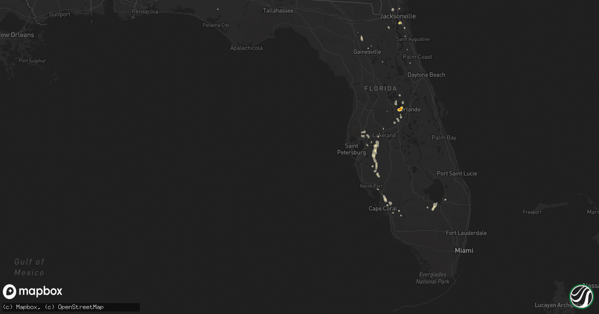
Hail Map in Florida on July 19, 2019
Get this storm
July 19 map
$229
one time, instant access
Download today. No call, no setup
Keep the $229
Bought the map and want the full workflow? Apply the entire $229 to a subscription within 7 days. None of it is wasted.
Every map, not just this one
This buys you this map. Subscription and you get every map we run, in the markets you choose from a few cities to whole states to nationwide. Plus real-time alerts the moment a storm fires.
Contact data
Name, contact info, occupancy, even credit band for addresses in the footprint. You go from where it hit to who to call.
Become the source they trust
Unlimited branding weather history reports on demand. You already have the documented answer ready for the property owner, and you are the one who showed up with it.
Property data and RoofTrace estimates
Pull up any address you have got, its value and the exact code rules for that jurisdiction, straight from One Click Code. Then RoofTrace estimates the squares, pitch, and roof value, priced the way you price.
Storm reports in Florida
Florida
| Date | Description |
|---|---|
| 07/19/20195:20 PM CDT | A local report indicates 1.75 inch wind near WINTER GARDEN |
| 07/19/20195:18 PM CDT | A local report indicates 1.00 inch wind near 4 SW OCOEE |
| 07/19/20195:15 PM CDT | Several reports of hail up to golf ball sized between 610 pm and 620 pm. |
| 07/19/20195:15 PM CDT | Delayed report. Em reports an oak tree blocking the road along with numerous two to three inch diameter branches down near stoneybrook west golf club. Time estimated fr |
| 07/19/20195:09 PM CDT | Vineland rd. And state road 50 |
| 07/19/20192:48 PM CDT | Communications received reports of a 6 to 8 inch diamter tree down along the road at northwest 30th terrace in gainesville. |
| 07/19/20192:10 PM CDT | Report of a tree down on a wire at the 1600 block of us 23. Time estimated by radar. |
| 07/19/20192:05 PM CDT | A 25 foot tall oak tree fell down onto the roadway by 37002 ingham drive. Time estimated by radar. |
| 07/19/20191:30 PM CDT | Communications received reports of a 6 to 8 inch diamter tree down along the road at northwest 30th terrace in gainesville. The time given was based on radar. |
| 07/19/20191:28 PM CDT | A tree was reported down at the address of 2445 nw 38th street. Time estimated by radar. |
| 07/19/201912:42 PM CDT | An nws spotter estimated quarter sized hail and 50 mph wind at jaybird circle west. |
| 07/19/20192:13 AM CDT | At 711 PM EDT, severe thunderstorms were located along a line extending from near Fish Hawk to 13 miles southeast of Greater Sun Center, moving northwest at 10 mph. HAZARD...60 mph wind gusts and quarter size hail. SOURCE...Radar indicated. IMPACT...Hail damage to vehicles is expected. Expect wind damage to roofs, siding, and trees. Locations impacted include... Brandon, Fish Hawk, Greater Sun Center, Riverview, Palm River-Clair Mel, Valrico, Alafia River State Park, Seffner, Mango, Dover, Fort Lonesome, Tampa Executive Airport, Boyette, Duette, Wimauma, Sun City Center, Lithia Springs State Park, Bloomingdale, Thonotosassa and Progress Village. |
| 07/19/20191:06 AM CDT | At 606 PM EDT, a severe thunderstorm was located over Winter Garden, moving southwest at 5 mph. HAZARD...60 mph wind gusts and quarter size hail. SOURCE...Radar indicated. IMPACT...Hail damage to vehicles is expected. Expect wind damage to roofs, siding, and trees. Locations impacted include... Ocoee, Winter Garden, Windermere, Bay Lake and Ferndale. |
| 07/19/201912:11 AM CDT | At 510 PM EDT, a severe thunderstorm was located 8 miles southwest of Babcock Webb Wma, or 11 miles southeast of Punta Gorda, moving north at 10 mph. HAZARD...60 mph wind gusts and quarter size hail. SOURCE...Radar indicated. IMPACT...Hail damage to vehicles is expected. Expect wind damage to roofs, siding, and trees. Locations impacted include... Cape Coral, Punta Gorda, Babcock Webb Wma, Charlotte County Airport, Pirate Harbor, Solana, Tropical Gulf Acres, Charlotte Park, Cleveland, Charlotte Harbor and North Fort Myers. |
| 07/18/201910:12 PM CDT | At 312 PM EDT, a severe thunderstorm was located over Worthington Spring, and is nearly stationary. HAZARD...60 mph wind gusts and quarter size hail. SOURCE...Radar indicated. IMPACT...Hail damage to vehicles is expected. Expect wind damage to roofs, siding, and trees. Locations impacted include... Worthington Spring, Worthington Springs, Upland Pines, Groves and Dukes. |
| 07/18/20199:14 PM CDT | At 214 PM EDT, a severe thunderstorm was located near Gainesville Airport, or 7 miles northeast of Gainesville, moving west at 10 mph. HAZARD...60 mph wind gusts and quarter size hail. SOURCE...Radar indicated. IMPACT...Hail damage to vehicles is expected. Expect wind damage to roofs, siding, and trees. Locations impacted include... Gainesville and Gainesville Airport. |
| 07/18/20198:38 PM CDT | At 138 PM EDT, a severe thunderstorm was located near Baymeadows, or near Mandarin, moving west at 10 mph. HAZARD...60 mph wind gusts and quarter size hail. SOURCE...Radar indicated. IMPACT...Hail damage to vehicles is expected. Expect wind damage to roofs, siding, and trees. Locations impacted include... Orange Park, Nas Jax, Baymeadows and Bellair-Meadowbrook Terrace. |
All States Impacted by Hail Map on July 19, 2019
Cities Impacted by Hail Map on July 19, 2019
- Waterford, PA
- Erie, PA
- Saint Peter, MN
- Prairie City, SD
- Reva, SD
- Buffalo, SD
- Belle Fourche, SD
- Bison, SD
- Alzada, MT
- Meadow, SD
- Currie, MN
- Lake Wilson, MN
- Holland, MN
- Woodstock, MN
- Pipestone, MN
- Edgerton, MN
- Slayton, MN
- Delhi, NY
- Franklin, PA
- Cambridge Springs, PA
- Titusville, PA
- Cooperstown, PA
- Guys Mills, PA
- Townville, PA
- Saegertown, PA
- Centerville, PA
- Meadville, PA
- Oil City, PA
- Pittsview, AL
- Hurtsboro, AL
- Hatchechubbee, AL
- Seale, AL
- Flandreau, SD
- Elkton, SD
- Ree Heights, SD
- Miller, SD
- Saint Lawrence, SD
- Le Sueur, MN
- Gaylord, MN
- Osakis, MN
- Swanville, MN
- Long Prairie, MN
- Donnelly, MN
- Kensington, MN
- Beardsley, MN
- Little Falls, MN
- Burtrum, MN
- Graceville, MN
- Dumont, MN
- Chokio, MN
- Glenwood, MN
- Farwell, MN
- Peever, SD
- Sisseton, SD
- Villard, MN
- West Union, MN
- Flensburg, MN
- Grey Eagle, MN
- Lowry, MN
- Morris, MN
- Browns Valley, MN
- Barry, MN
- Cyrus, MN
- Alexandria, MN
- Sauk Centre, MN
- Madelia, MN
- Polk City, FL
- Cornell, WI
- Cadott, WI
- Kimball, SD
- Sylvania, GA
- Onamia, MN
- Ruidoso, NM
- Phillips, WI
- Gleason, WI
- Reed City, MI
- Orient, SD
- Mankato, MN
- Good Thunder, MN
- Askov, MN
- Willow River, MN
- Bruno, MN
- Sandstone, MN
- Finlayson, MN
- Dupree, SD
- Eagle Butte, SD
- Rhinelander, WI
- Loyal, WI
- Unity, WI
- Chili, WI
- Marshfield, WI
- Spencer, WI
- Onaka, SD
- Oconto, WI
- Saint Augustine, FL
- Atmore, AL
- Kennan, WI
- Catawba, WI
- Prentice, WI
- Isabel, SD
- Timber Lake, SD
- Oronoco, MN
- Byron, MN
- Rochester, MN
- Pine Island, MN
- Kane, PA
- Wilcox, PA
- Westwego, LA
- Whatley, AL
- Ipswich, SD
- Ozark, AL
- Dothan, AL
- Headland, AL
- Midland City, AL
- Newton, AL
- Brainerd, MN
- Tomahawk, WI
- Warner Robins, GA
- Bonaire, GA
- Faith, SD
- Mud Butte, SD
- Ocoee, FL
- Winter Garden, FL
- Stanley, WI
- Thorp, WI
- Midland, SD
- Jesup, GA
- Lithia, FL
- Winter, WI
- Lennon, MI
- Corunna, MI
- Flushing, MI
- Jacksonville, GA
- McRae Helena, GA
- Ty Ty, GA
- Poulan, GA
- Sumner, GA
- White Owl, SD
- Saint Stephens, AL
- Leroy, AL
- Pelican Lake, WI
- Park Falls, WI
- Stone Lake, WI
- Couderay, WI
- Tripoli, WI
- Hayward, WI
- Brantwood, WI
- Ojibwa, WI
- Radisson, WI
- Lockport, NY
- Gasport, NY
- Andersonville, GA
- Brandt, SD
- Astoria, SD
- Eagle Bend, MN
- Parkers Prairie, MN
- Middleport, NY
- Cuba, NY
- Friendship, NY
- Clymer, NY
- Corry, PA
- Wattsburg, PA
- Amery, WI
- Osceola, WI
- Star Prairie, WI
- Deer Park, WI
- New Richmond, WI
- Hinckley, MN
- Cushing, WI
- Stanchfield, MN
- Wahkon, MN
- Frederic, WI
- Pine City, MN
- Hillman, MN
- Grasston, MN
- Mora, MN
- Henriette, MN
- Isle, MN
- Pierz, MN
- Brook Park, MN
- Luck, WI
- Braham, MN
- Grantsburg, WI
- Rush City, MN
- Ulmer, SC
- South Rockwood, MI
- Flat Rock, MI
- Trenton, MI
- Detroit, MI
- Rockwood, MI
- New Boston, MI
- Carleton, MI
- Romulus, MI
- Ypsilanti, MI
- Belleville, MI
- Friona, TX
- Saint Croix Falls, WI
- Soperton, GA
- Lakeland, FL
- Riverview, FL
- Bowdle, SD
- Lebanon, SD
- Faulkton, SD
- Selby, SD
- Ridgeview, SD
- Cresbard, SD
- Hoven, SD
- Hammond, MT
- Gettysburg, SD
- Hulett, WY
- Tolstoy, SD
- Java, SD
- Seneca, SD
- Roscoe, SD
- Union Center, SD
- McIntosh, SD
- Newell, SD
- Fairchild, WI
- Humbird, WI
- Willard, WI
- Columbiaville, MI
- Uriah, AL
- South Bay, FL
- Junction City, WI
- Stevens Point, WI
- Sheldon, WI
- Merrill, WI
- Athens, WI
- Charlotte, NC
- Astatula, FL
- Clermont, FL
- Fort Ripley, MN
- Alma Center, WI
- Merrillan, WI
- Mantorville, MN
- Kasson, MN
- Harsens Island, MI
- Cannon Afb, NM
- Selma, AL
- Philip, SD
- Cambridge, MN
- Warren, PA
- Russell, PA
- Fort Rucker, AL
- Groveland, FL
- Dodge Center, MN
- Albion, NY
- Prairie Farm, WI
- Dallas, WI
- Barron, WI
- Arlington, MN
- Necedah, WI
- Troy, AL
- Capitol, MT
- Mount Dora, FL
- Hitchcock, SD
- Carpenter, SD
- Huron, SD
- Yale, SD
- Cato, NY
- Saluda, SC
- Gann Valley, SD
- Wessington Springs, SD
- Laurinburg, NC
- Maxton, NC
- Highmore, SD
- Jacksonville, FL
- Cushing, MN
- Randall, MN
- Browerville, MN
- Luther, MI
- Baldwin, MI
- Fountain, MI
- Irons, MI
- Free Soil, MI
- Branch, MI
- Dallas, NC
- Mount Holly, NC
- Gastonia, NC
- Stanley, NC
- Gilman, WI
- Boyd, WI
- Sebeka, MN
- North Branch, MN
- Marion, AL
- Garden City, SD
- Colby, WI
- Pulaski, WI
- Krakow, WI
- Oconto Falls, WI
- Saint James, MN
- Hartsville, SC
- Bishopville, SC
- Lynchburg, SC
- Lamar, SC
- Elliott, SC
- Butternut, WI
- Glidden, WI
- Princeton, MN
- North Fort Myers, FL
- Hereford, TX
- Hawkins, WI
- Lake Park, GA
- Cumberland, WI
- Chetek, WI
- Rice Lake, WI
- New Auburn, WI
- Centuria, WI
- Almena, WI
- Ridgeland, WI
- Comstock, WI
- Cameron, WI
- Center City, MN
- Turtle Lake, WI
- Clayton, WI
- Milltown, WI
- Taylors Falls, MN
- Allegany, NY
- Robbinsville, NC
- Shinglehouse, PA
- Macon, GA
- Aladdin, WY
- Devils Tower, WY
- Boyes, MT
- Fort Myers, FL
- Parrish, FL
- Iola, WI
- Ogdensburg, WI
- Howell, MI
- Brighton, MI
- Linden, MI
- Fenton, MI
- Milford, MI
- Highland, MI
- Hartland, MI
- South Lyon, MI
- Fowlerville, MI
- Holly, MI
- Pinckney, MI
- Whitmore Lake, MI
- Plymouth, MI
- Ann Arbor, MI
- Millerton, PA
- Gillett, PA
- Plant City, FL
- Chapin, SC
- Mount Vernon, AL
- McIntosh, AL
- Nicollet, MN
- Gainesville, FL
- Rebecca, GA
- Fitzgerald, GA
- Bertha, MN
- Townsend, WI
- Tallassee, AL
- Lake Butler, FL
- Ogilvie, MN
- Bunnell, FL
- Lindstrom, MN
- Trego, WI
- Spooner, WI
- Crivitz, WI
- Louisville, MS
- Oakland, FL
- Windermere, FL
- Clarissa, MN
- Vining, MN
- Henning, MN
- Holcombe, WI
- Dorchester, WI
- Westfield, PA
- White, SD
- Dadeville, AL
- Hilliard, FL
- Tampa, FL
- Lutz, FL
- Wyoming, MN
- Stacy, MN
- Defuniak Springs, FL
- Owatonna, MN
- Colfax, WI
- Wheeler, WI
- Boyceville, WI
- Greenwood, WI
- Chippewa Falls, WI
- Eau Claire, WI
- Augusta, WI
- Fall Creek, WI
- Kent City, MI
- Bailey, MI
- Casnovia, MI
- Ridgway, PA
- Union City, PA
- Addison, NY
- Alachua, FL
- Milaca, MN
- Faribault, MN
- Green Bay, WI
- Ludington, MI
- Thompson, OH
- Madison, OH
- Chatom, AL
- Howes, SD
- Milesville, SD
- Wall, SD
- Cherry Creek, SD
- Curtiss, WI
- Owen, WI
- Granton, WI
- Edinboro, PA
- Franklinville, NY
- Ellicottville, NY
- Lancaster, SC
- Fort Lawn, SC
- Great Falls, SC
- Aitkin, MN
- Dovray, MN
- Westbrook, MN
- Wadena, MN
- Menahga, MN
- Roslyn, SD
- Langford, SD
- Conneautville, PA
- Springboro, PA
- Eufaula, AL
- Abbeville, AL
- Chester, SC
- Deatsville, AL
- Marbury, AL
- Enning, SD
- New York Mills, MN
- Turton, SD
- Doland, SD
- Middleburg, FL
- Pearson, WI
- Pickerel, WI
- Elcho, WI
- Cedar, MN
- Bethel, MN
- Chisago City, MN
- Forest Lake, MN
- Caro, MI
- Waynesboro, MS
- Buckatunna, MS
- Sturgeon Lake, MN
- Marienville, PA
- Battle Lake, MN
- Clitherall, MN
- Deerbrook, WI
- Sabinsville, PA
- Mentor, OH
- Montezuma, GA
- Oglethorpe, GA
- Clear Lake, WI
- Glenwood City, WI
- Downing, WI
- Edgar, WI
- Abbotsford, WI
- Stetsonville, WI
- Youngsville, PA
- Irvine, PA
- Raymond, SD
- Clintonville, WI
- Marion, WI
- Bear Creek, WI
- Manawa, WI
- Mosinee, WI
- Liberty Hill, SC
- Crandon, WI
- Black River Falls, WI
- Janesville, MN
- Sheffield, PA
- Sumter, SC
- Beatrice, AL
- Eagle Lake, MN
- Chipley, FL
- Grove Hill, AL
- Thomasville, AL
- Dickinson, AL
- Saint Joseph, MN
- Claremont, MN
- West Concord, MN
- Webberville, MI
- Perry, MI
- Babcock, WI
- Sylvester, GA
- Tyler, MN
- Grand Rapids, MI
- Comstock Park, MI
- Sparta, MI
- Henderson, MN
- Siren, WI
- Underwood, MN
- Wessington, SD
- Andrews, NC
- Willow Lake, SD
- Iroquois, SD
- Avoca, MN
- Winnsboro, SC
- Clam Lake, WI
- Rosholt, WI
- Shiocton, WI
- Myakka City, FL
- Hydetown, PA
- Florence, SD
- Withee, WI
- Tiona, PA
- Dry Branch, GA
- Fredonia, PA
- Greenville, PA
- Irmo, SC
- Prescott, MI
- West Branch, MI
- Lupton, MI
- Williamston, MI
- Springbrook, WI
- Storden, MN
- Sanborn, MN
- Lamberton, MN
- Jeffers, MN
- Plains, GA
- Rhine, GA
- Bloomer, WI
- Weyerhaeuser, WI
- Lublin, WI
- Balsam Lake, WI
- Mountain, WI
- Dansville, MI
- Mason, MI
- Apopka, FL
- Neillsville, WI
- Westboro, WI
- Ogema, WI
- Eleva, WI
- Adams, WI
- Rives Junction, MI
- Mescalero, NM
- Millry, AL
- De Smet, SD
- Linesville, PA
- Pomaria, SC
- McGrath, MN
- Clark, SD
- Orlando, FL
- Bryant, SD
- Newport, MI
- Taylor, MI
- Canton, MI
- Wayne, MI
- Riverview, MI
- Willis, MI
- McColl, SC
- Clio, SC
- Lavonia, GA
- Goshen, AL
- McLaughlin, SD
- Utica, PA
- Fifield, WI
- Harshaw, WI
- Punta Gorda, FL
- Pittsville, WI
- Bennettsville, SC
- Wallace, SC
- Darfur, MN
- Arpin, WI
- Seffner, FL
- Thonotosassa, FL
- Idlewild, MI
- Chase, MI
- Blackshear, GA
- Sleepy Eye, MN
- Comfrey, MN
- Springfield, MN
- Milan, GA
- Staples, MN
- Wabeno, WI
- Birchwood, WI
- Summit Lake, WI
- White Lake, WI
- Mountain Lake, MN
- Butterfield, MN
- Pleasantville, PA
- Glen Flora, WI
- Grenville, SD
- Hewitt, MN
- Dalton, MN
- Camp Hill, AL
- Jacksons Gap, AL
- Panama, NY
- Clarendon, PA
- Pittsfield, PA
- Spring Creek, PA
- Ashville, NY
- Sugar Grove, PA
- New Albany, PA
- Monroeton, PA
- Clear Lake, SD
- Toronto, SD
- Gary, SD
- Clovis, NM
- New Lothrop, MI
- Mondovi, WI
- Lake Crystal, MN
- Beaver Dams, NY
- Kissimmee, FL
- Davenport, FL
- Broadus, MT
- Manistee, MI
- Friendship, WI
- Grand Marsh, WI
- Chardon, OH
- Oneonta, NY
- Shawano, WI
- Windsor, NY
- Kirkwood, NY
- Sturgeon Bay, WI
- Wrightsville, GA
- Holabird, SD
- New London, WI
- Grand Valley, PA
- Nekoosa, WI
- Silas, AL
- Grant, MI
- Gaines, PA
- Port Charlotte, FL
- Gresham, WI
- Bath, MI
- Laingsburg, MI
- Pine Apple, AL
- Warrens, WI
- Medford, MN
- Clanton, AL
- Verbena, AL
- Albany, GA
- Camp Douglas, WI
- Citronelle, AL
- Notasulga, AL
- Lena, WI
- Balaton, MN
- Montello, WI
- Gibson, NC
- Andover, SD
- Groton, SD
- Whitewood, SD
- Tioga, PA
- Lawrenceville, PA
- Orwell, OH
- Kinde, MI
- Amherst Junction, WI
- Wittenberg, WI
- Hatley, WI
- Custer, WI
- Corning, NY
- Lindley, NY
- Painted Post, NY
- Hixton, WI
- Osseo, WI
- Caseville, MI
- Red Level, AL
- Mansfield, PA
- Sorrento, FL
- Loxahatchee, FL
- Geneva, OH
- Austinburg, OH
- Franklin, NY
- East Meredith, NY
- Treadwell, NY
- Otego, NY
- Auburndale, WI
- Milladore, WI
- Marathon, WI
- Stratford, WI
- Lake Preston, SD
- Hanska, MN
- Mars Hill, NC
- Westminster, SC
- Toccoa, GA
- Pine City, NY
- Northville, MI
- Jim Falls, WI
- Dresser, WI
- Harris, MN
- Jay, FL
- Conklin, MI
- Ravenna, MI
- Wyalusing, PA
- Towanda, PA
- Lehigh Acres, FL
- Hale, MI
- Wadley, GA
- Fort McCoy, FL
- Saint Clair Shores, MI
- Ladysmith, WI
- Weyauwega, WI
- Aurora, SD
- Elk Mound, WI
- Lowell, NC
- Hastings, FL
- Granville Summit, PA
- Canton, PA
- Fort Valley, GA
- Perry, GA
- Columbia, AL
- Wanamingo, MN
- Fayetteville, NC
- Roseville, MI
- Clewiston, FL
- Casco, WI
- Luxemburg, WI
- Lower Peach Tree, AL
- Grandy, MN
- Dalbo, MN
- Laurel Hill, NC
- Hamlet, NC
- Plover, WI
- Chunchula, AL
- Egg Harbor, WI
- Danbury, WI
- Minong, WI
- Gordon, WI
- Strum, WI
- Arkdale, WI
- Suamico, WI
- Martin, GA
- Ninety Six, SC
- Green Valley, WI
- Sobieski, WI
- Abrams, WI
- Cecil, WI
- Bonduel, WI
- Cochranton, PA
- Carlton, PA
- Algoma, WI
- Richmond, MI
- Artesian, SD
- Painesville, OH
- Chula, GA
- Sycamore, GA
- Deerwood, MN
- Sherman, NY
- Capitan, NM
- Midway, AL
- Zimmerman, MN
- Miltona, MN
- Altoona, WI
- Isanti, MN
- Shafer, MN
- Garrison, MN
- Big Lake, MN
- Mapleton, MN
- Saint Johns, FL
- Aberdeen, SD
- Clarington, PA
- Sigel, PA
- Wimauma, FL
- Ripley, NY
- Westfield, NY
- Ponce De Leon, FL
- Scottville, MI
- Custer, MI
- Columbus, PA
- Saint Helen, MI
- Flint, MI
- Swartz Creek, MI
- Moorcroft, WY
- Hersey, MI
- Folkston, GA
- Heath Springs, SC
- Durand, MI
- Vernon, MI
- Garden City, MN
- Richburg, SC
- Cape Coral, FL
- Mainesburg, PA
- Morrice, MI
- Valrico, FL
- West Oneonta, NY
- Almond, NC
- Kathleen, GA
- Hoffman, MN
- North Tonawanda, NY
- Tonawanda, NY
- Buffalo, NY
- Grand Island, NY
- Mesick, MI
- Arcadia, MI
- Thompsonville, MI
- Bear Lake, MI
- Copemish, MI
- Benzonia, MI
- Beulah, MI
- Lake Ann, MI
- Honor, MI
- Interlochen, MI
- Harrietta, MI
- Wellston, MI
- Cadillac, MI
- Boon, MI
- Shelby, MI
- Belmont, MI
- Newaygo, MI
- Montague, MI
- White Cloud, MI
- Bitely, MI
- Sand Lake, MI
- Fremont, MI
- Howard City, MI
- Ada, MI
- Coopersville, MI
- Nunica, MI
- Middleville, MI
- Delton, MI
- Mears, MI
- Walkerville, MI
- Caledonia, MI
- Cedar Springs, MI
- Marne, MI
- Muskegon, MI
- Hastings, MI
- Pentwater, MI
- Rothbury, MI
- New Era, MI
- Rockford, MI
- Hart, MI
- Holton, MI
- Freeport, MI
- Hesperia, MI
- Spring Lake, MI
- Alto, MI
- Twin Lake, MI
- Fruitport, MI
- Byron Center, MI
- Hudsonville, MI
- Grandville, MI
- Jenison, MI
- Kalamazoo, MI
- Hickory Corners, MI
- Scotts, MI
- Shelbyville, MI
- Wayland, MI
- Augusta, MI
- Richland, MI
- Martin, MI
- Plainwell, MI
- Portage, MI
- Galesburg, MI
- Climax, MI
- Dorr, MI
- Sunfield, MI
- Olivet, MI
- Mulliken, MI
- Charlotte, MI
- Vermontville, MI
- Harrison Township, MI
- Clinton Township, MI
- Claremont, SD
- Columbia, SD
- Lake City, SD
- Bath, SD
- Eden, SD
- Pierpont, SD
- Warner, SD
- Agar, SD
- Harrold, SD
- Pierre, SD
- White Lake, SD
- Redfield, SD
- Henry, SD
- Mitchell, SD
- Fedora, SD
- Cavour, SD
- Letcher, SD
- Erwin, SD
- Alpena, SD
- Wolsey, SD
- Plankinton, SD
- Woonsocket, SD
- Mount Vernon, SD
- Tulare, SD
- Virgil, SD
- Carthage, SD
- Frankfort, SD
- Vienna, SD
- Chamberlain, SD
- Lower Brule, SD
- Kennebec, SD
- Oacoma, SD
- Reliance, SD
- Pukwana, SD
- Lantry, SD
- Fort Pierre, SD
- Hayes, SD
- Orr, MN
- Exeland, WI
- Medford, WI
- Wausau, WI
- Eland, WI
- Tigerton, WI
- Birnamwood, WI
- Schofield, WI
- Rothschild, WI
- Keshena, WI
- Bryant, WI
- Neopit, WI
- Rib Lake, WI
- Seymour, WI
- Hazelhurst, WI
- Bowler, WI
- Coleman, WI
- Aniwa, WI
- Pound, WI
- Antigo, WI
- Lakewood, WI
- Irma, WI
- Suring, WI
- Elton, WI
- Gillett, WI
- Mattoon, WI
- Leopolis, WI
- Kewaunee, WI
- Mishicot, WI
- Two Rivers, WI
- Denmark, WI
- Manitowoc, WI
- Whitelaw, WI
- Maribel, WI
- Winona, MN
- Texico, NM
- Farmdale, OH
- Cortland, OH
- West Middlesex, PA
- Fowler, OH
- Hermitage, PA
- Masury, OH
- Wheatland, PA
- Sharon, PA
- New Wilmington, PA
- Edinburg, PA
- Lowellville, OH
- Brookfield, OH
- Portersville, PA
- New Castle, PA
- Hubbard, OH
- Burghill, OH
- Pulaski, PA
- Farrell, PA
- Ellwood City, PA
- Du Bois, PA
- Brookville, PA
- Brockway, PA
- Penfield, PA
- Brockport, PA


