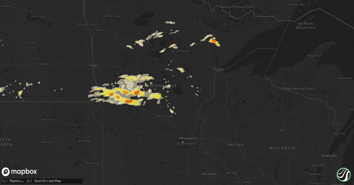
Hail Map in Minnesota on July 17, 2017
Get this storm
July 17 map
$229
one time, instant access
Download today. No call, no setup
Keep the $229
Bought the map and want the full workflow? Apply the entire $229 to a subscription within 7 days. None of it is wasted.
Every map, not just this one
This buys you this map. Subscription and you get every map we run, in the markets you choose from a few cities to whole states to nationwide. Plus real-time alerts the moment a storm fires.
Contact data
Name, contact info, occupancy, even credit band for addresses in the footprint. You go from where it hit to who to call.
Become the source they trust
Unlimited branding weather history reports on demand. You already have the documented answer ready for the property owner, and you are the one who showed up with it.
Property data and RoofTrace estimates
Pull up any address you have got, its value and the exact code rules for that jurisdiction, straight from One Click Code. Then RoofTrace estimates the squares, pitch, and roof value, priced the way you price.
Storm reports in Minnesota
Minnesota
| Date | Description |
|---|---|
| 07/17/20176:59 PM CDT | Time estimated from radar. |
| 07/17/20176:53 PM CDT | Reported via off-duty officer through 911 center. |
| 07/17/20176:45 PM CDT | A local report indicates 1.00 inch wind near RANDALL |
| 07/17/20176:45 PM CDT | Relayed report of golf ball size hail from local media. Time corrected. |
| 07/17/20176:40 PM CDT | Numerous tree branches down. |
| 07/17/20176:35 PM CDT | Relayed report of golf ball size hail from local media. |
| 07/17/20176:30 PM CDT | Numerous tree limbs down in pierz. |
| 07/17/20176:20 PM CDT | Large tree limbs down. |
| 07/17/20176:12 PM CDT | Time estimated from radar. |
| 07/17/20176:09 PM CDT | Few trees downed on the north end of big sandy lake. Time estimated from radar. |
| 07/17/20175:55 PM CDT | Between 545 pm and 645 pm spotter measured 1.50 inches of rain. |
| 07/17/20175:50 PM CDT | Several large trees down on the north side of brandon. |
| 07/17/20175:40 PM CDT | Trees down on powerlines both east & northeast of browerville. Time estimated from radar. |
| 07/17/20175:37 PM CDT | Public works department doing removal of several downed trees throughout town. Time estimated by radar. |
| 07/17/20175:33 PM CDT | Social media report and photo of damage to a dock on the western end of gull lake. |
| 07/17/20175:30 PM CDT | Few downed trees on nelson road and tower road. Time estimated from radar. |
| 07/17/20175:23 PM CDT | A local report indicates 65 MPH wind near 3 N BRAINERD |
| 07/17/20175:18 PM CDT | A few 6 inch diameter trees snapped a couple feet off the ground. Time estimated from radar. |
| 07/17/20175:15 PM CDT | Lots of quarter to ping pong ball sized hail near interstate 94 in western pelican lake township. |
| 07/17/20175:08 PM CDT | A local report indicates 1.75 inch wind near 2 WSW EAGLE BEND |
| 07/17/20175:06 PM CDT | A local report indicates 1.75 inch wind near 3 SW BERTHA |
| 07/17/20175:05 PM CDT | 12 to 16 inch box elder tree snapped about 8 to 10 ft off the ground. Winds came after the storm had passed. |
| 07/17/20174:55 PM CDT | Trees down across hwy 64. Report relayed from nws-mpx. Time estimated from radar. |
| 07/17/20174:55 PM CDT | Lots of quarter to golf ball sized hail and strong winds across southern aastad township. |
| 07/17/20174:50 PM CDT | A local report indicates 1.50 inch wind near 5 SSE CLITHERALL |
| 07/17/20174:42 PM CDT | Quarter to golf ball sized hail covered the highway. Few stones still falling at 445 pm cdt. |
| 07/17/20174:10 PM CDT | Hail of quarter to half dollar size. |
| 07/17/20174:05 PM CDT | Large hail fell for several minutes across southern orwell township. |
| 07/17/20173:55 PM CDT | Semi truck and trailer combination blown over on u. S. Highway 10. Time estimated based on radar. |
| 07/17/20171:38 AM CDT | Nickel to quarter sized hail between wilton and bemidji |
| 07/16/20178:00 PM CDT | Time estimated by radar. |
| 07/16/20177:59 PM CDT | A few 6 inch diameter trees downed at the whiteface reservoir campground. Time estimated from radar. |
| 07/16/20177:25 PM CDT | Few trees downed...with the largest being a 26 inch diameter elm tree snapped 8 feet off the ground. Time estimated from radar. |
| 07/16/20177:05 PM CDT | A local report indicates 60 MPH wind near 2 S MOOSE LAKE |
| 07/16/20177:00 PM CDT | Largest hail was half dollar sized...in addition had lots of smaller hail that accumulated on the ground. Time estimated from radar. |
| 07/16/20177:00 PM CDT | Tree limbs down blocking streets in town. |
All States Impacted by Hail Map on July 17, 2017
Cities Impacted by Hail Map on July 17, 2017
- Presho, SD
- Selfridge, ND
- Perham, MN
- New York Mills, MN
- Amherst, NE
- Ravenna, NE
- Wahpeton, ND
- Breckenridge, MN
- Big Falls, MN
- Holland Patent, NY
- Cozad, NE
- Henning, MN
- Mcgregor, MN
- Palisade, MN
- Phillipsburg, KS
- Alma, NE
- Clarissa, MN
- Eagle Bend, MN
- Browerville, MN
- Verndale, MN
- Hickory, NC
- Connelly Springs, NC
- Arapahoe, NE
- Beaver City, NE
- Edison, NE
- Oxford, NE
- McIntosh, SD
- Fairburn, SD
- Buffalo Gap, SD
- Clitherall, MN
- Battle Lake, MN
- Vining, MN
- Roscoe, SD
- Mizpah, MN
- Northome, MN
- Hildreth, NE
- Wishek, ND
- Ashley, ND
- Bagley, MN
- Independence, VA
- Troutdale, VA
- Elk Creek, VA
- Pine Grove, PA
- Fredericksburg, PA
- Biglerville, PA
- Aspers, PA
- Gardners, PA
- Bendersville, PA
- Carlisle, PA
- Shelton, NE
- Deer Creek, MN
- Ipswich, SD
- Blackduck, MN
- Cullman, AL
- Mathias, WV
- Baker, WV
- Glorieta, NM
- Elm Creek, NE
- Miller, NE
- Hewitt, MN
- Brainerd, MN
- Dalmatia, PA
- Elizabethville, PA
- Berrysburg, PA
- Ottertail, MN
- Oak Park, MN
- Foley, MN
- New Leipzig, ND
- Aurora, MN
- Gilbert, MN
- Wilcox, NE
- Republican City, NE
- Thurmont, MD
- Woodsboro, MD
- Frederick, MD
- Walkersville, MD
- Keymar, MD
- Hallstead, PA
- Montrose, PA
- Conestoga, PA
- Pequea, PA
- Cushing, MN
- Motley, MN
- Overton, NE
- Almena, KS
- Stamford, NE
- Long Island, KS
- Norton, KS
- Gordon, NE
- Hunt, TX
- Columbia, VA
- Evansville, MN
- Hoffman, MN
- Ashby, MN
- Dalton, MN
- Elbow Lake, MN
- Nashua, MN
- Barrett, MN
- Fergus Falls, MN
- Brandon, MN
- Campbell, MN
- Wendell, MN
- Garfield, MN
- Owings Mills, MD
- Reisterstown, MD
- Finksburg, MD
- Wadley, AL
- Randall, MN
- Little Falls, MN
- Wadena, MN
- Sebeka, MN
- Taylorsville, NC
- Parkers Prairie, MN
- Bertha, MN
- Penokee, KS
- Hill City, KS
- Martin, SD
- Elgin, ND
- Gaylesville, AL
- Minden, NE
- Naponee, NE
- Greer, SC
- Taylors, SC
- Linton, ND
- Show Low, AZ
- Sumner, NE
- Yucca, AZ
- Chapel Hill, NC
- Durham, NC
- Hot Springs, SD
- Morris Plains, NJ
- Oconto, NE
- Eddyville, NE
- Pine Ridge, SD
- Wolsey, SD
- Waitsfield, VT
- Warren, VT
- Pierz, MN
- Bath, PA
- Nazareth, PA
- Lenora, KS
- Glenvil, NE
- Blue Hill, NE
- Clark, SD
- Raymond, SD
- Mission, SD
- Marana, AZ
- Axtell, NE
- Funk, NE
- Grover, CO
- Rowe, MA
- Barneveld, NY
- Stittville, NY
- Remsen, NY
- Rome, NY
- Kimball, SD
- Platte, SD
- Piermont, NH
- Lincoln, NH
- Campton, NH
- Thornton, NH
- Wentworth, NH
- North Woodstock, NH
- Warren, NH
- Orford, NH
- Onaka, SD
- Gothenburg, NE
- Long Lake, SD
- Beaverdam, VA
- Eustis, NE
- Farnam, NE
- Gaithersburg, MD
- Montgomery Village, MD
- Saint Lawrence, SD
- Hamill, SD
- Keyser, WV
- Lynchburg, VA
- Rustburg, VA
- Long Valley, SD
- Butler, NJ
- Boonton, NJ
- Cross Junction, VA
- Prairie View, KS
- Bloomington, NE
- Holdrege, NE
- Orleans, NE
- Saint Cloud, FL
- Alexandria, MN
- Underwood, MN
- Carlos, MN
- Miltona, MN
- Long Prairie, MN
- Nelson, MN
- Foxhome, MN
- Fairmount, ND
- Osakis, MN
- Squaw Lake, MN
- Marsland, NE
- Forksville, PA
- Hillsgrove, PA
- Las Vegas, NV
- Staples, MN
- Glen Lyon, PA
- Hunlock Creek, PA
- Wilkes Barre, PA
- Merriman, NE
- Prescott, AZ
- Chester, VT
- Ludlow, VT
- Weston, VT
- Clark Mills, NY
- New Hartford, NY
- Clinton, NY
- Yorkville, NY
- Whitesboro, NY
- New York Mills, NY
- Hialeah, FL
- New Windsor, MD
- Tintah, MN
- Brattleboro, VT
- West Halifax, VT
- Mount Wolf, PA
- Emigsville, PA
- York, PA
- Manchester, PA
- Lehr, ND
- Fredonia, ND
- Jackman, ME
- Willow Lake, SD
- Yale, SD
- Carpenter, SD
- Batesland, SD
- Rushville, NE
- Agar, SD
- Lake Pleasant, NY
- Speculator, NY
- Clanton, AL
- Deland, FL
- Eustis, FL
- Bowdle, SD
- Nanticoke, PA
- Berwick, PA
- Wapwallopen, PA
- Kingston, PA
- Gouldsboro, PA
- Bear Creek, PA
- Mountain Top, PA
- Shickshinny, PA
- Plymouth, PA
- Letcher, SD
- Keewatin, MN
- Hibbing, MN
- Custer, SD
- Lower Brule, SD
- Mountain Iron, MN
- Shenandoah Junction, WV
- Cavour, SD
- Iroquois, SD
- Bemidji, MN
- Solway, MN
- Mayer, AZ
- North Sandwich, NH
- Paulden, AZ
- Kearney, NE
- Hanover, PA
- Mason City, NE
- Fayetteville, PA
- Chambersburg, PA
- Rising Sun, MD
- Nottingham, PA
- Orlando, FL
- Ruther Glen, VA
- Norcross, MN
- Mount Tremper, NY
- Shokan, NY
- Boiceville, NY
- Bearsville, NY
- Myerstown, PA
- Bethel, PA
- Marion, NC
- Strasburg, ND
- Jacksonville, VT
- Whitingham, VT
- Purlear, NC
- Winkelman, AZ
- Oglala, SD
- Hitchcock, SD
- Newport, NY
- Little Falls, NY
- De Smet, SD
- Murphysboro, IL
- Tamarack, MN
- White River, SD
- Hines, MN
- San Manuel, AZ
- Willcox, AZ
- Rice, MN
- Scottsville, VA
- Quarryville, PA
- Edgeley, ND
- Merrifield, MN
- Nisswa, MN
- Millersburg, PA
- Pillow, PA
- Lykens, PA
- Faulkton, SD
- South Tamworth, NH
- Bigfork, MN
- Gregory, SD
- Centreville, MD
- Queenstown, MD
- Church Hill, MD
- Deer River, MN
- Grand Rapids, MN
- Cohasset, MN
- Loup City, NE
- Port Trevorton, PA
- Kingman, AZ
- Mount Airy, MD
- Bangor, PA
- Bumpass, VA
- Mineral, VA
- Lexington, NE
- Smithfield, NE
- Altoona, AL
- Wyalusing, PA
- Laceyville, PA
- Sugar Run, PA
- Wessington, SD
- Jonestown, PA
- Bluffton, MN
- Mount Union, PA
- McVeytown, PA
- Parmelee, SD
- McGrath, MN
- Finlayson, MN
- Germantown, MD
- Inverness, FL
- Bedford, PA
- Sulligent, AL
- Easton, PA
- Silver Springs, FL
- Birmingham, AL
- Shevlin, MN
- Fort Ripley, MN
- Swanville, MN
- Pine River, MN
- Charlemont, MA
- Amsterdam, NY
- Leola, SD
- Watauga, SD
- Morristown, SD
- Ocala, FL
- Readsboro, VT
- Denver, PA
- Augusta, WV
- Littlestown, PA
- Gettysburg, PA
- Parker, AZ
- Winner, SD
- Witten, SD
- Lonaconing, MD
- Barton, MD
- Manchester, MD
- Westminster, MD
- Charlotte Court House, VA
- Keysville, VA
- Farmville, VA
- Pulaski, VA
- Dublin, VA
- Moultonborough, NH
- Ashland, NH
- Plymouth, NH
- New Hampton, NH
- Tamworth, NH
- Chocorua, NH
- Bristol, NH
- Center Sandwich, NH
- Holderness, NH
- Center Harbor, NH
- Carson, ND
- Union Bridge, MD
- Dahlonega, GA
- Federal Dam, MN
- Cody, NE
- Gettysburg, SD
- Clearwater, FL
- Woodland, AL
- Eureka, SD
- James Creek, PA
- Saxton, PA
- Callahan, FL
- Jacksonville, FL
- Max, MN
- Oral, SD
- Hettinger, ND
- Jemison, AL
- Deridder, LA
- Makinen, MN
- Biwabik, MN
- Eveleth, MN
- Loomis, NE
- Bertrand, NE
- King Ferry, NY
- Landrum, SC
- Weston, WY
- Gillette, WY
- Richville, MN
- Rothsay, MN
- Cleveland, AL
- Oneonta, AL
- Blountsville, AL
- Hayden, AL
- Seligman, AZ
- Everett, PA
- Conway, NH
- Rumney, NH
- Gainesville, FL
- Dent, MN
- Frazee, MN
- Sauk Centre, MN
- Conover, NC
- Woodville, AL
- Scottsboro, AL
- Buhl, AL
- Hankinson, ND
- Virginia, MN
- Embarrass, MN
- Granite Falls, NC
- Princeton, MN
- Westmoreland, NY
- Oriskany, NY
- Aitkin, MN
- Elwood, NE
- Huron, SD
- Doland, SD
- Sandstone, MN
- Ramseur, NC
- Todd, PA
- Trout Run, PA
- Coker, AL
- Britt, MN
- Aldrich, MN
- Chino Valley, AZ
- Apopka, FL
- Sorrento, FL
- Port Saint Lucie, FL
- Prescott Valley, AZ
- Leesburg, AL
- Collinsville, AL
- Chisholm, MN
- Kinney, MN
- Buhl, MN
- Ideal, SD
- Moorefield, NE
- New Enterprise, PA
- Gwinner, ND
- Moundville, AL
- Arcadia, NE
- Ord, NE
- McLaughlin, SD
- Lenoir, NC
- Hoffmeister, NY
- Appomattox, VA
- Ludlow, SD
- Oracle, AZ
- Montoursville, PA
- Muncy, PA
- Proctorsville, VT
- Mount Holly, VT
- Cavendish, VT
- Beverly Hills, FL
- Dunnellon, FL
- Bladen, NE
- Binghamton, NY
- Ironton, MN
- Vernon, NY
- Bloomery, WV
- Capon Bridge, WV
- Spring Grove, PA
- Thomasville, PA
- Red Lion, PA
- Kissimmee, FL
- Deerwood, MN
- Chestertown, MD
- Huntingdon, PA
- Mitchell, SD
- Lake Preston, SD
- Saint Francis, SD
- Powhatan, VA
- Berlin, PA
- Fairhope, PA
- Buffalo Mills, PA
- Manns Choice, PA
- Nashwauk, MN
- Poland, NY
- Prospect, NY
- Cold Brook, NY
- Palmyra, VA
- Napoleon, ND
- Cartersville, VA
- Oakes, ND
- Shunk, PA
- Williamsport, PA
- Bessemer, AL
- Ralph, SD
- Emily, MN
- Dolgeville, NY
- Gratz, PA
- Herndon, PA
- Kennedyville, MD
- Earleville, MD
- Holbrook, NE
- Liverpool, PA
- Mount Pleasant Mills, PA
- Havre De Grace, MD
- Aberdeen, MD
- Callaway, NE
- Williamstown, MA
- Millers Creek, NC
- Warfordsburg, PA
- Utopia, TX
- Kennebec, SD
- Monrovia, MD
- Harman, WV
- Hanceville, AL
- Glyndon, MD
- Newland, NC
- Askov, MN
- Burke, SD
- Meredith, NH
- Sanbornton, NH
- Eden Prairie, MN
- Oacoma, SD
- Reliance, SD
- White Lake, SD
- Remer, MN
- Chadron, NE
- Crawford, NE
- Middleburg, FL
- Northville, NY
- Foreston, MN
- Devils Tower, WY
- Crane Hill, AL
- Thomasville, AL
- Waterville, PA
- Tryon, NC
- Mill Spring, NC
- Moorefield, WV
- Royalton, MN
- Todd, NC
- Patton, MO
- Marble Hill, MO
- Hondo, TX
- Trussville, AL
- Leeds, AL
- Lakeland, FL
- Fort Payne, AL
- Fifty Lakes, MN
- Frankfort, SD
- New Milford, PA
- Kingsley, PA
- Riverdale, NJ
- Bloomingdale, NJ
- Woonsocket, SD
- Coldspring, TX
- Saint Augustine, FL
- Fort Yates, ND
- Pleasanton, NE
- Erhard, MN
- Wessington Springs, SD
- Jacob, IL
- Gorham, IL
- Cary, NC
- North Wilkesboro, NC
- Moravian Falls, NC
- Boone, NC
- Lebanon, PA
- Richland, PA
- Caliente, NV
- Muncy Valley, PA
- Wedowee, AL
- Brackettville, TX
- Osteen, FL
- Geneva, FL
- Deltona, FL
- Saint Johns, FL
- Rosholt, SD
- Vergas, MN
- Mooreton, ND
- Wheaton, MN
- Mantador, ND
- Morganton, NC
- Paisley, FL
- Pierson, FL
- Huntsville, AL
- Meadow, SD
- Forestport, NY
- Pamplin, VA
- Cullen, VA
- Hazard, NE
- Rockville, NE
- Ansley, NE
- Rutherfordton, NC
- Elizabeth, MN
- Ranburne, AL
- Winchester, VA
- Gibbon, NE
- West Shokan, NY
- Cloudcroft, NM
- Fredericktown, MO
- Outing, MN
- Kintyre, ND
- Washington Boro, PA
- Jersey Shore, PA
- Seville, FL
- Rutland, VT
- Killington, VT
- Pittsfield, VT
- Moorcroft, WY
- Bremo Bluff, VA
- Dadeville, AL
- Friendsville, PA
- Brackney, PA
- Daviston, AL
- Bagdad, AZ
- Clifton, AZ
- Marriottsville, MD
- Randallstown, MD
- Attalla, AL
- Vivian, SD
- North Clarendon, VT
- Pengilly, MN
- Willow River, MN
- Hague, ND
- Bison, SD
- Wirt, MN
- Randolph, NJ
- Dawsonville, GA
- Orange City, FL
- Sudlersville, MD
- Heartwell, NE
- Lamont, FL
- Cuttingsville, VT
- Chittenden, VT
- Stockbridge, VT
- Hebron, NH
- West Ossipee, NH
- Wells, NY


