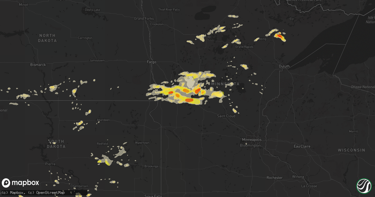
Hail Map on July 17, 2017
Get this storm
July 17 map
$229
one time, instant access
Download today. No call, no setup
Keep the $229
Bought the map and want the full workflow? Apply the entire $229 to a subscription within 7 days. None of it is wasted.
Every map, not just this one
This buys you this map. Subscription and you get every map we run, in the markets you choose from a few cities to whole states to nationwide. Plus real-time alerts the moment a storm fires.
Contact data
Name, contact info, occupancy, even credit band for addresses in the footprint. You go from where it hit to who to call.
Become the source they trust
Unlimited branding weather history reports on demand. You already have the documented answer ready for the property owner, and you are the one who showed up with it.
Property data and RoofTrace estimates
Pull up any address you have got, its value and the exact code rules for that jurisdiction, straight from One Click Code. Then RoofTrace estimates the squares, pitch, and roof value, priced the way you price.
States Impacted by Hail Map on July 17, 2017
Storm reports
Maryland
| Date | Description |
|---|---|
| 07/17/20175:45 PM CDT | A local report indicates 1.00 inch wind near CENTREVILLE |
| 07/17/20173:24 PM CDT | Several tree branches down in the 9600 block of brink rd |
| 07/17/20172:58 PM CDT | Tree down near rt 140 and glen falls rd |
| 07/17/20172:39 PM CDT | Multiple trees down at the intersection of churchill downs road and woodfield road. |
| 07/17/20172:37 PM CDT | Tree down along woodfield road at churchill downs road |
| 07/17/20172:34 PM CDT | A local report indicates 1.00 inch wind near LAYTONSVILLE |
| 07/17/20172:34 PM CDT | Tree down along woodfield road at rocky road |
| 07/17/20172:34 PM CDT | Two large tree branches blocked the intersecton of augusta farm lane and woodfield road. |
| 07/17/20172:30 PM CDT | A local report indicates 1.00 inch wind near LAYTONSVILLE |
New York
| Date | Description |
|---|---|
| 07/17/20174:58 PM CDT | Jewell road near kober road. Reports of wires down across roadway. |
| 07/17/20173:51 PM CDT | Trees down. |
| 07/17/20173:50 PM CDT | Trees and wires down on daniels rd near route 9 |
| 07/17/20173:44 PM CDT | Lewis road. Report of a tree down across roadway. |
| 07/17/20173:40 PM CDT | Daniels road near maple ave route 9. Reports of trees and wires down in the roadway. |
| 07/17/20173:33 PM CDT | Jewell road near kober road. Reports of wires down across roadway. |
| 07/17/20173:33 PM CDT | Eastline road between route 67 and east high street. Several reports of trees down across the roadway. |
| 07/17/20173:32 PM CDT | Tree snapped off 20 feet up from the ground |
| 07/17/20173:31 PM CDT | Downed tree. |
| 07/17/20173:30 PM CDT | More than 10 trees uprooted or snapped on an ouaquaga road property |
| 07/17/20173:19 PM CDT | Wires down. Time estimated by radar. |
| 07/17/20173:03 PM CDT | Tree down on power lines on pigeon hill rd. |
| 07/17/20173:01 PM CDT | Reports of two downed trees in amsterdam. One on truax road and second near intersection of church street and cornell street. |
| 07/17/20172:58 PM CDT | Tree and powerlines down in the vicinity of june st. And birdsall st. |
| 07/17/20172:50 PM CDT | Tree down causing a motor vehicle accident on rt. 12 and oak hill rd. |
| 07/17/20172:49 PM CDT | Trees and electrical wires down |
| 07/17/20172:16 PM CDT | Power outage due to downed tree. |
| 07/17/20171:42 PM CDT | Downed tree. Time estimated by radar. |
| 07/17/201712:10 PM CDT | Also reported trees down at mason lake. |
| 07/17/201712:05 PM CDT | Power line down in roadway |
| 07/17/201712:02 PM CDT | Tree down in roadway... Windows blown out of residential structure |
| 07/17/201711:58 AM CDT | Tree down blocking rodawai in in vicinity of fillmore glenn state park |
| 07/17/201711:35 AM CDT | Mostly quarter size hail with a few golf ball sized. Also large tree limbs fell. |
South Carolina
| Date | Description |
|---|---|
| 07/17/20177:56 AM CDT | Quarter sized hail in the highland community. Also had strong wind but no damage reported although tigerville fire department reported there are scattered power outages |
| 07/16/20177:56 PM CDT | Quarter sized hail in the highland community. Also had strong wind but no damage reported although tigerville fire department reported there are scattered power outages |
Pennsylvania
| Date | Description |
|---|---|
| 07/17/20174:20 PM CDT | Trees down |
| 07/17/20174:20 PM CDT | Trees down. |
| 07/17/20173:40 PM CDT | Tree down on wires resulting in road closure. |
| 07/17/20171:40 PM CDT | Multiple trees down with debris in roadway in the vicinity of franklin hill rd. |
| 07/17/20171:35 PM CDT | Trees down. |
| 07/17/20171:27 PM CDT | Tree down blocking roadway |
| 07/17/201712:56 PM CDT | Report of 1.5 hail and 1.76 of rain in 40 minutes |
| 07/17/201712:30 PM CDT | A local report indicates 1.00 inch wind near ASHLEY |
| 07/17/201712:25 PM CDT | Trees down in fireside and avenues neighborhoods in the city of york. |
Vermont
| Date | Description |
|---|---|
| 07/17/20176:24 PM CDT | A local report indicates 1.00 inch wind near JACKSONVILLE |
| 07/17/20175:22 PM CDT | A local report indicates 1.00 inch wind near PROCTORSVILLE |
| 07/17/20175:00 PM CDT | Trees and powerlines down on south hill road |
| 07/17/20175:00 PM CDT | A local report indicates 1.00 inch wind near 3 S LUDLOW |
| 07/17/20174:20 PM CDT | A local report indicates 1.00 inch wind near LUDLOW |
| 07/17/20171:30 PM CDT | Hail size of quarters along the killington/pittsfield town line along rt 100 |
Arizona
| Date | Description |
|---|---|
| 07/17/20176:02 PM CDT | Quarter size hail reported near hackberry rd. Time estimated via radar. |
| 07/17/20175:32 PM CDT | Ksad asos wind gust to 50 kts. |
| 07/17/201711:14 AM CDT | Five miles north of iron springs road on williamson valley rd. -- golf ball sized hail. |
| 07/17/20171:00 AM CDT | Trees knocked down. |
| 07/16/20177:25 PM CDT | Power lines and trees down. |
Alabama
| Date | Description |
|---|---|
| 07/17/20175:31 PM CDT | Trees and power lines down on tyler street. |
| 07/17/20175:12 PM CDT | A few trees were blown down around walnut grove. |
| 07/17/20174:48 PM CDT | A few trees were blown down near moody. |
| 07/17/20174:44 PM CDT | Trees and power lines down at 12th street and alabama avenue. |
| 07/17/20174:42 PM CDT | A large tree and several power poles knocked down on tuscaloosa avenue. |
| 07/17/20174:39 PM CDT | Tree down on east meighan blvd blocking a lane. |
| 07/17/20174:30 PM CDT | A large tree and power lines down on ross drive and coates bend road. |
| 07/17/20174:24 PM CDT | A few trees were blown down around alexander city on tiger lane... Kerley patten road... And mallory circle. |
| 07/17/20174:18 PM CDT | Trees blown down blocking both lanes of traffic on horseshoe bend road. |
| 07/17/20174:00 PM CDT | Trees down blocking a lane on us highway 411 near the etowah and cherokee county line. |
| 07/17/20173:43 PM CDT | Trees and power lines were blown down on sand rock avenue. |
| 07/17/20173:43 PM CDT | Multiple trees were blown down near the intersection of cr 70 and cr 36 near sand rock. |
| 07/17/20173:36 PM CDT | Trees down on indian hills road and mission road. |
| 07/17/20173:26 PM CDT | Power lines were blown down on cr 44... Cr 698... And cr 102 near cedar bluff. |
| 07/17/20173:22 PM CDT | Trees down on overton road. |
| 07/17/20173:20 PM CDT | Trees blown down on southridge drive. |
| 07/17/20173:20 PM CDT | A large tree down and blocking the road at montevallo road and overhill road. |
| 07/17/20173:17 PM CDT | Trees blown down on sunset drive. |
| 07/17/20173:17 PM CDT | Power lines were blown down on north river road. |
| 07/17/20172:30 PM CDT | A few trees were blown down near moody. |
Nevada
| Date | Description |
|---|---|
| 07/17/20175:15 PM CDT | Brick wall destroyed near silverado ranch blvd and lindell. Picture sent in via social media. |
| 07/17/20175:15 PM CDT | Large tree limb downed onto fence near e windmill ln and bermuda rd. Picture sent in via social media. |
| 07/17/20175:05 PM CDT | Large tree downed by thunderstorm winds at bermuda and windmill. Picture sent in via social media. |
| 07/17/20174:55 PM CDT | Tree uprooted near blue diamond rd and decatur blvd. Picture sent in via social media. |
| 07/17/20174:55 PM CDT | Multiple trees downed near w windmill ln and rainbow blvd. Pictures sent in via social media. |
| 07/17/20174:52 PM CDT | Tree downed near w robindale rd and s tenaya way. |
| 07/17/20174:52 PM CDT | Large tree downed near s rainbow and w wigwam ave. Picture sent in via social media. |
| 07/17/20174:50 PM CDT | Wooden structure destroyed from strong winds near w wigwam and s durango dr. Pictures sent in via social media. |
| 07/17/20174:50 PM CDT | Several trees downed in restaurant parking lot. |
| 07/17/20174:50 PM CDT | Six large trees uprooted and destroyed. Eight small trees heavily damaged. Two road signs damaged and fencing destroyed at sierra vista high school. |
| 07/17/20174:42 PM CDT | Tree downed near aventura park in henderson. Picture sent in via social media. |
| 07/17/20174:28 PM CDT | Wind gust of 65 mph. Site whlrv. |
| 07/17/20174:24 PM CDT | Wind gust of 60 mph. Site lsgtl. |
South Dakota
| Date | Description |
|---|---|
| 07/17/20176:47 PM CDT | A local report indicates 72 MPH wind near PRESHO |
| 07/17/20176:15 PM CDT | 60 mph wind gusts and pea to dime sized hail. |
| 07/17/20176:10 PM CDT | 60 to 70 mph winds and dime size hail. |
| 07/17/20175:38 PM CDT | A local report indicates 64 MPH wind near 13 N VIVIAN |
| 07/17/20175:25 PM CDT | Few hail stones as big as quarters and a brief period of gusty winds estimated up to 60 mph. |
| 07/17/20175:08 PM CDT | A local report indicates 1.00 inch wind near 9 N OGLALA |
| 07/17/20173:07 PM CDT | Car windshield broken due to hail |
| 07/17/20176:10 AM CDT | A local report indicates 60 MPH wind near 4 N CRAVENS CORNER |
| 07/17/20175:30 AM CDT | A local report indicates 59 MPH wind near 5 S RICHMOND LAKE REC A |
| 07/17/20173:57 AM CDT | 50-60 mph. |
| 07/17/20173:19 AM CDT | Occurred with outflow ahead of thunderstorms. |
| 07/17/20173:10 AM CDT | Small tree limbs down... Radar estimated time. |
| 07/17/20172:24 AM CDT | Radar estimated time |
| 07/16/20179:24 PM CDT | A local report indicates 60 MPH wind near 1 S OGLALA |
| 07/16/20178:45 PM CDT | A local report indicates 70 MPH wind near 2 WNW OLDHAM |
| 07/16/20178:40 PM CDT | Time estimated from radar. |
| 07/16/20178:40 PM CDT | Time estimated from radar. |
| 07/16/20178:17 PM CDT | Strong winds ahead of the storm stirred up enough dust to reduce visibility to less than 1/8 of a mile. |
| 07/16/20178:05 PM CDT | A local report indicates 60 MPH wind near NEW UNDERWOOD |
| 07/16/20177:50 PM CDT | A local report indicates 1.00 inch wind near 3 S WIND CAVE VISITORS |
| 07/16/20177:50 PM CDT | A local report indicates 60 MPH wind near 4 SSW RAPID CITY |
| 07/16/20177:50 PM CDT | A local report indicates 60 MPH wind near 4 SW RAPID CITY |
| 07/16/20177:45 PM CDT | Big tree down in huron... Blocking a city street. |
| 07/16/20177:44 PM CDT | Kicked up a large amount of dust. |
| 07/16/20177:30 PM CDT | Nice rain and no hail... But pretty strong winds!. |
| 07/16/20177:28 PM CDT | A local report indicates 65 MPH wind near OACOMA |
| 07/16/20177:02 PM CDT | Hail up to the size of quarters and wind gusts estimated at 60 mph. Some tree branches blown down and corn was tipped. |
North Dakota
| Date | Description |
|---|---|
| 07/17/20173:40 PM CDT | Second round of hail. Lots of nickel to quarter sized. |
Kansas
| Date | Description |
|---|---|
| 07/16/201711:55 PM CDT | A local report indicates 1.00 inch wind near 7 SSE NORTON |
| 07/16/20177:50 PM CDT | A local report indicates 60 MPH wind near 8 SE WOODRUFF |
Montana
| Date | Description |
|---|---|
| 07/16/201711:54 PM CDT | A local report indicates 68 MPH wind near 7 SE EKALAKA |
Massachusetts
| Date | Description |
|---|---|
| 07/16/20177:11 PM CDT | A local report indicates 1.00 inch wind near ROWE |
Minnesota
| Date | Description |
|---|---|
| 07/17/20176:59 PM CDT | Time estimated from radar. |
| 07/17/20176:53 PM CDT | Reported via off-duty officer through 911 center. |
| 07/17/20176:45 PM CDT | Relayed report of golf ball size hail from local media. Time corrected. |
| 07/17/20176:45 PM CDT | A local report indicates 1.00 inch wind near RANDALL |
| 07/17/20176:40 PM CDT | Numerous tree branches down. |
| 07/17/20176:35 PM CDT | Relayed report of golf ball size hail from local media. |
| 07/17/20176:30 PM CDT | Numerous tree limbs down in pierz. |
| 07/17/20176:20 PM CDT | Large tree limbs down. |
| 07/17/20176:12 PM CDT | Time estimated from radar. |
| 07/17/20176:09 PM CDT | Few trees downed on the north end of big sandy lake. Time estimated from radar. |
| 07/17/20175:55 PM CDT | Between 545 pm and 645 pm spotter measured 1.50 inches of rain. |
| 07/17/20175:50 PM CDT | Several large trees down on the north side of brandon. |
| 07/17/20175:40 PM CDT | Trees down on powerlines both east & northeast of browerville. Time estimated from radar. |
| 07/17/20175:37 PM CDT | Public works department doing removal of several downed trees throughout town. Time estimated by radar. |
| 07/17/20175:33 PM CDT | Social media report and photo of damage to a dock on the western end of gull lake. |
| 07/17/20175:30 PM CDT | Few downed trees on nelson road and tower road. Time estimated from radar. |
| 07/17/20175:23 PM CDT | A local report indicates 65 MPH wind near 3 N BRAINERD |
| 07/17/20175:18 PM CDT | A few 6 inch diameter trees snapped a couple feet off the ground. Time estimated from radar. |
| 07/17/20175:15 PM CDT | Lots of quarter to ping pong ball sized hail near interstate 94 in western pelican lake township. |
| 07/17/20175:08 PM CDT | A local report indicates 1.75 inch wind near 2 WSW EAGLE BEND |
| 07/17/20175:06 PM CDT | A local report indicates 1.75 inch wind near 3 SW BERTHA |
| 07/17/20175:05 PM CDT | 12 to 16 inch box elder tree snapped about 8 to 10 ft off the ground. Winds came after the storm had passed. |
| 07/17/20174:55 PM CDT | Lots of quarter to golf ball sized hail and strong winds across southern aastad township. |
| 07/17/20174:55 PM CDT | Trees down across hwy 64. Report relayed from nws-mpx. Time estimated from radar. |
| 07/17/20174:50 PM CDT | A local report indicates 1.50 inch wind near 5 SSE CLITHERALL |
| 07/17/20174:42 PM CDT | Quarter to golf ball sized hail covered the highway. Few stones still falling at 445 pm cdt. |
| 07/17/20174:10 PM CDT | Hail of quarter to half dollar size. |
| 07/17/20174:05 PM CDT | Large hail fell for several minutes across southern orwell township. |
| 07/17/20173:55 PM CDT | Semi truck and trailer combination blown over on u. S. Highway 10. Time estimated based on radar. |
| 07/17/20171:38 AM CDT | Nickel to quarter sized hail between wilton and bemidji |
| 07/16/20178:00 PM CDT | Time estimated by radar. |
| 07/16/20177:59 PM CDT | A few 6 inch diameter trees downed at the whiteface reservoir campground. Time estimated from radar. |
| 07/16/20177:25 PM CDT | Few trees downed...with the largest being a 26 inch diameter elm tree snapped 8 feet off the ground. Time estimated from radar. |
| 07/16/20177:05 PM CDT | A local report indicates 60 MPH wind near 2 S MOOSE LAKE |
| 07/16/20177:00 PM CDT | Largest hail was half dollar sized...in addition had lots of smaller hail that accumulated on the ground. Time estimated from radar. |
| 07/16/20177:00 PM CDT | Tree limbs down blocking streets in town. |
Virginia
| Date | Description |
|---|---|
| 07/17/20176:32 PM CDT | Multiple trees knocked down. Time estimated from radar. |
| 07/17/20176:15 PM CDT | Trees down at 300 bumpass road and green coral road. |
| 07/17/20172:12 PM CDT | Tree down near intersection of bethel and big ridge roads. |
| 07/17/20172:10 PM CDT | Tree down on private property off of big ridge road. |
| 07/17/20174:42 AM CDT | Tree down on meadville road at chatham road |
Wyoming
| Date | Description |
|---|---|
| 07/17/20175:45 PM CDT | 0.70 of rain in about 30 minutes |
| 07/16/201710:50 PM CDT | A local report indicates 60 MPH wind near 1 WNW HULETT |
| 07/16/20179:38 PM CDT | A local report indicates 60 MPH wind near 7 NW WESTON |
North Carolina
| Date | Description |
|---|---|
| 07/17/20176:13 PM CDT | Power pole snapped with lines on ground at us70 near east burke blvd. |
| 07/17/20175:57 PM CDT | Several trees down on robinson st. |
| 07/17/20175:52 PM CDT | Tree on i40 at mm 115. |
| 07/17/20175:52 PM CDT | Tree across miller bridge rd at shoupes grove church rd. |
| 07/17/20175:45 PM CDT | Multiple trees down across western alexander county. |
| 07/17/20175:40 PM CDT | Tree down on berea church road. |
| 07/17/20175:27 PM CDT | Dime to quarter sized hail about a quarter mile south of the river on the connelly springs side. |
| 07/17/20175:26 PM CDT | Hail was increasing at the time of the call going from dime sized to quarter sized. Strong wind also but so far no damage. |
| 07/17/20175:15 PM CDT | Multiple trees down in the area. |
| 07/17/20175:09 PM CDT | Lenoir fd reports trees on powerline. |
| 07/17/20175:05 PM CDT | Nickel to quarter sized hail on north side of hickory. Strong wind but no sign yet of wind damage. |
| 07/17/20174:50 PM CDT | Multiple trees down across western alexander county. |
| 07/17/20174:26 PM CDT | Quarter sized hail. Very strong wind seeing limbs blow by in the parking lot but not sure how large the limbs were. |
| 07/17/20174:26 PM CDT | Numerous trees down around taylorsville. |
West Virginia
| Date | Description |
|---|---|
| 07/17/20175:30 PM CDT | Large walnut tree down due to thunderstorm winds. |
| 07/17/20175:30 PM CDT | A local report indicates 1.00 inch wind near KEYSER |
| 07/17/20175:30 PM CDT | A local report indicates 1.00 inch wind near 2 SSW KEYSER |
| 07/17/20175:20 PM CDT | A local report indicates 1.00 inch wind near 2 SSW KEYSER |
New Hampshire
| Date | Description |
|---|---|
| 07/17/20176:50 PM CDT | Trees and wires down in bartlett. |
| 07/17/20176:20 PM CDT | Quarter to nickel size hail |
| 07/17/20174:40 PM CDT | Wires down around town. |
| 07/16/20177:05 PM CDT | A local report indicates 1.00 inch wind near 3 SW TAMWORTH |
Georgia
| Date | Description |
|---|---|
| 07/17/20176:41 PM CDT | Tree down on the road at the 2800 block of old norcross rd in duluth |
| 07/17/20176:40 PM CDT | Trees down on amwiler rd and humphies way |
| 07/17/20176:36 PM CDT | Tree down on powerlines on edgewood lane |
| 07/17/20176:22 PM CDT | Powerlines down on pleasent hill rd at hill dr |
| 07/17/20176:20 PM CDT | Powerlines down on steve dr at buford hwy |
| 07/17/20176:16 PM CDT | Tree down on powerlines on suwanee creek rd in suwanee |
Nebraska
| Date | Description |
|---|---|
| 07/16/201710:30 PM CDT | South side of gordon. |
| 07/16/201710:02 PM CDT | Wind gusts to 60 mph at this location along with quarter size hail. |
| 07/16/20178:37 PM CDT | A local report indicates 58 MPH wind near 3 SW COWLES |
Maine
| Date | Description |
|---|---|
| 07/17/20174:50 PM CDT | Mostly dime and nickel size hail with some larger stones mixed in. Time estimated from radar. |
| 07/17/201711:52 AM CDT | One large tree and several small trees down. Time estimated based on radar. |
Mississippi
| Date | Description |
|---|---|
| 07/17/20176:30 PM CDT | Trees down across new salem rd. |
| 07/17/20175:48 PM CDT | Tree on powerline on spring drive. |
| 07/17/20175:48 PM CDT | Tree down on w. Court street |
| 07/17/20175:45 PM CDT | Powerline down on hwy 550 near hwy 51. |
| 07/17/20175:45 PM CDT | Powerline down on industrial park rd. |
Utah
| Date | Description |
|---|---|
| 07/17/20175:50 PM CDT | Mesonet station dpg14 |
| 07/17/20175:20 PM CDT | Mesonet station dpg09 |
| 07/17/20175:10 PM CDT | Udot mesonet station ut33 |
| 07/17/20175:05 PM CDT | Mesonet station dpg15 |
| 07/17/20175:05 PM CDT | Mesonet station dpg17 |
| 07/16/20177:05 PM CDT | Mesonet station freut |
Florida
| Date | Description |
|---|---|
| 07/17/20174:55 PM CDT | Trained spotter reports quarter sized hail near us 192 in st. Cloud |
| 07/17/20173:48 PM CDT | Report of quarter sized hail and trees down in the mount plymouth/sorrento area. Time estimated from radar |
| 07/17/20172:40 PM CDT | Duval county emergency management reports that a tree was downed by strong wind gusts and crashed into an apartment building along harts road.time of damage based on ra |
| 07/17/20172:15 PM CDT | Duval county emergency management reports a tree downed along dodge road that crashed through the living room of a house. Time of damage based on radar data. |
| 07/17/201710:30 AM CDT | There were a few sporadic power outages in the area due to trees from strong wind as well as lightning. |
Wisconsin
| Date | Description |
|---|---|
| 07/16/20178:25 PM CDT | Tree downed on county road t blocking one lane of traffic between oakland and jackson township. Time estimated from radar. |
Illinois
| Date | Description |
|---|---|
| 07/17/20173:00 PM CDT | Several trees and power lines down across town. |
Cities Impacted by Hail Map on July 17, 2017
- Presho, SD
- Selfridge, ND
- Perham, MN
- New York Mills, MN
- Amherst, NE
- Ravenna, NE
- Wahpeton, ND
- Breckenridge, MN
- Big Falls, MN
- Holland Patent, NY
- Cozad, NE
- Henning, MN
- Mcgregor, MN
- Palisade, MN
- Phillipsburg, KS
- Alma, NE
- Clarissa, MN
- Eagle Bend, MN
- Browerville, MN
- Verndale, MN
- Hickory, NC
- Connelly Springs, NC
- Arapahoe, NE
- Beaver City, NE
- Edison, NE
- Oxford, NE
- McIntosh, SD
- Fairburn, SD
- Buffalo Gap, SD
- Clitherall, MN
- Battle Lake, MN
- Vining, MN
- Roscoe, SD
- Mizpah, MN
- Northome, MN
- Hildreth, NE
- Wishek, ND
- Ashley, ND
- Bagley, MN
- Independence, VA
- Troutdale, VA
- Elk Creek, VA
- Pine Grove, PA
- Fredericksburg, PA
- Biglerville, PA
- Aspers, PA
- Gardners, PA
- Bendersville, PA
- Carlisle, PA
- Shelton, NE
- Deer Creek, MN
- Ipswich, SD
- Blackduck, MN
- Cullman, AL
- Mathias, WV
- Baker, WV
- Glorieta, NM
- Elm Creek, NE
- Miller, NE
- Hewitt, MN
- Brainerd, MN
- Dalmatia, PA
- Elizabethville, PA
- Berrysburg, PA
- Ottertail, MN
- Oak Park, MN
- Foley, MN
- New Leipzig, ND
- Aurora, MN
- Gilbert, MN
- Wilcox, NE
- Republican City, NE
- Thurmont, MD
- Woodsboro, MD
- Frederick, MD
- Walkersville, MD
- Keymar, MD
- Hallstead, PA
- Montrose, PA
- Conestoga, PA
- Pequea, PA
- Cushing, MN
- Motley, MN
- Overton, NE
- Almena, KS
- Stamford, NE
- Long Island, KS
- Norton, KS
- Gordon, NE
- Hunt, TX
- Columbia, VA
- Evansville, MN
- Hoffman, MN
- Ashby, MN
- Dalton, MN
- Elbow Lake, MN
- Nashua, MN
- Barrett, MN
- Fergus Falls, MN
- Brandon, MN
- Campbell, MN
- Wendell, MN
- Garfield, MN
- Owings Mills, MD
- Reisterstown, MD
- Finksburg, MD
- Wadley, AL
- Randall, MN
- Little Falls, MN
- Wadena, MN
- Sebeka, MN
- Taylorsville, NC
- Parkers Prairie, MN
- Bertha, MN
- Penokee, KS
- Hill City, KS
- Martin, SD
- Elgin, ND
- Gaylesville, AL
- Minden, NE
- Naponee, NE
- Greer, SC
- Taylors, SC
- Linton, ND
- Show Low, AZ
- Sumner, NE
- Yucca, AZ
- Chapel Hill, NC
- Durham, NC
- Hot Springs, SD
- Morris Plains, NJ
- Oconto, NE
- Eddyville, NE
- Pine Ridge, SD
- Wolsey, SD
- Waitsfield, VT
- Warren, VT
- Pierz, MN
- Bath, PA
- Nazareth, PA
- Lenora, KS
- Glenvil, NE
- Blue Hill, NE
- Clark, SD
- Raymond, SD
- Mission, SD
- Marana, AZ
- Axtell, NE
- Funk, NE
- Grover, CO
- Rowe, MA
- Barneveld, NY
- Stittville, NY
- Remsen, NY
- Rome, NY
- Kimball, SD
- Platte, SD
- Piermont, NH
- Lincoln, NH
- Campton, NH
- Thornton, NH
- Wentworth, NH
- North Woodstock, NH
- Warren, NH
- Orford, NH
- Onaka, SD
- Gothenburg, NE
- Long Lake, SD
- Beaverdam, VA
- Eustis, NE
- Farnam, NE
- Gaithersburg, MD
- Montgomery Village, MD
- Saint Lawrence, SD
- Hamill, SD
- Keyser, WV
- Lynchburg, VA
- Rustburg, VA
- Long Valley, SD
- Butler, NJ
- Boonton, NJ
- Cross Junction, VA
- Prairie View, KS
- Bloomington, NE
- Holdrege, NE
- Orleans, NE
- Saint Cloud, FL
- Alexandria, MN
- Underwood, MN
- Carlos, MN
- Miltona, MN
- Long Prairie, MN
- Nelson, MN
- Foxhome, MN
- Fairmount, ND
- Osakis, MN
- Squaw Lake, MN
- Marsland, NE
- Forksville, PA
- Hillsgrove, PA
- Las Vegas, NV
- Staples, MN
- Glen Lyon, PA
- Hunlock Creek, PA
- Wilkes Barre, PA
- Merriman, NE
- Prescott, AZ
- Chester, VT
- Ludlow, VT
- Weston, VT
- Clark Mills, NY
- New Hartford, NY
- Clinton, NY
- Yorkville, NY
- Whitesboro, NY
- New York Mills, NY
- Hialeah, FL
- New Windsor, MD
- Tintah, MN
- Brattleboro, VT
- West Halifax, VT
- Mount Wolf, PA
- Emigsville, PA
- York, PA
- Manchester, PA
- Lehr, ND
- Fredonia, ND
- Jackman, ME
- Willow Lake, SD
- Yale, SD
- Carpenter, SD
- Batesland, SD
- Rushville, NE
- Agar, SD
- Lake Pleasant, NY
- Speculator, NY
- Clanton, AL
- Deland, FL
- Eustis, FL
- Bowdle, SD
- Nanticoke, PA
- Berwick, PA
- Wapwallopen, PA
- Kingston, PA
- Gouldsboro, PA
- Bear Creek, PA
- Mountain Top, PA
- Shickshinny, PA
- Plymouth, PA
- Letcher, SD
- Keewatin, MN
- Hibbing, MN
- Custer, SD
- Lower Brule, SD
- Mountain Iron, MN
- Shenandoah Junction, WV
- Cavour, SD
- Iroquois, SD
- Bemidji, MN
- Solway, MN
- Mayer, AZ
- North Sandwich, NH
- Paulden, AZ
- Kearney, NE
- Hanover, PA
- Mason City, NE
- Fayetteville, PA
- Chambersburg, PA
- Rising Sun, MD
- Nottingham, PA
- Orlando, FL
- Ruther Glen, VA
- Norcross, MN
- Mount Tremper, NY
- Shokan, NY
- Boiceville, NY
- Bearsville, NY
- Myerstown, PA
- Bethel, PA
- Marion, NC
- Strasburg, ND
- Jacksonville, VT
- Whitingham, VT
- Purlear, NC
- Winkelman, AZ
- Oglala, SD
- Hitchcock, SD
- Newport, NY
- Little Falls, NY
- De Smet, SD
- Murphysboro, IL
- Tamarack, MN
- White River, SD
- Hines, MN
- San Manuel, AZ
- Willcox, AZ
- Rice, MN
- Scottsville, VA
- Quarryville, PA
- Edgeley, ND
- Merrifield, MN
- Nisswa, MN
- Millersburg, PA
- Pillow, PA
- Lykens, PA
- Faulkton, SD
- South Tamworth, NH
- Bigfork, MN
- Gregory, SD
- Centreville, MD
- Queenstown, MD
- Church Hill, MD
- Deer River, MN
- Grand Rapids, MN
- Cohasset, MN
- Loup City, NE
- Port Trevorton, PA
- Kingman, AZ
- Mount Airy, MD
- Bangor, PA
- Bumpass, VA
- Mineral, VA
- Lexington, NE
- Smithfield, NE
- Altoona, AL
- Wyalusing, PA
- Laceyville, PA
- Sugar Run, PA
- Wessington, SD
- Jonestown, PA
- Bluffton, MN
- Mount Union, PA
- McVeytown, PA
- Parmelee, SD
- McGrath, MN
- Finlayson, MN
- Germantown, MD
- Inverness, FL
- Bedford, PA
- Sulligent, AL
- Easton, PA
- Silver Springs, FL
- Birmingham, AL
- Shevlin, MN
- Fort Ripley, MN
- Swanville, MN
- Pine River, MN
- Charlemont, MA
- Amsterdam, NY
- Leola, SD
- Watauga, SD
- Morristown, SD
- Ocala, FL
- Readsboro, VT
- Denver, PA
- Augusta, WV
- Littlestown, PA
- Gettysburg, PA
- Parker, AZ
- Winner, SD
- Witten, SD
- Lonaconing, MD
- Barton, MD
- Manchester, MD
- Westminster, MD
- Charlotte Court House, VA
- Keysville, VA
- Farmville, VA
- Pulaski, VA
- Dublin, VA
- Moultonborough, NH
- Ashland, NH
- Plymouth, NH
- New Hampton, NH
- Tamworth, NH
- Chocorua, NH
- Bristol, NH
- Center Sandwich, NH
- Holderness, NH
- Center Harbor, NH
- Carson, ND
- Union Bridge, MD
- Dahlonega, GA
- Federal Dam, MN
- Cody, NE
- Gettysburg, SD
- Clearwater, FL
- Woodland, AL
- Eureka, SD
- James Creek, PA
- Saxton, PA
- Callahan, FL
- Jacksonville, FL
- Max, MN
- Oral, SD
- Hettinger, ND
- Jemison, AL
- Deridder, LA
- Makinen, MN
- Biwabik, MN
- Eveleth, MN
- Loomis, NE
- Bertrand, NE
- King Ferry, NY
- Landrum, SC
- Weston, WY
- Gillette, WY
- Richville, MN
- Rothsay, MN
- Cleveland, AL
- Oneonta, AL
- Blountsville, AL
- Hayden, AL
- Seligman, AZ
- Everett, PA
- Conway, NH
- Rumney, NH
- Gainesville, FL
- Dent, MN
- Frazee, MN
- Sauk Centre, MN
- Conover, NC
- Woodville, AL
- Scottsboro, AL
- Buhl, AL
- Hankinson, ND
- Virginia, MN
- Embarrass, MN
- Granite Falls, NC
- Princeton, MN
- Westmoreland, NY
- Oriskany, NY
- Aitkin, MN
- Elwood, NE
- Huron, SD
- Doland, SD
- Sandstone, MN
- Ramseur, NC
- Todd, PA
- Trout Run, PA
- Coker, AL
- Britt, MN
- Aldrich, MN
- Chino Valley, AZ
- Apopka, FL
- Sorrento, FL
- Port Saint Lucie, FL
- Prescott Valley, AZ
- Leesburg, AL
- Collinsville, AL
- Chisholm, MN
- Kinney, MN
- Buhl, MN
- Ideal, SD
- Moorefield, NE
- New Enterprise, PA
- Gwinner, ND
- Moundville, AL
- Arcadia, NE
- Ord, NE
- McLaughlin, SD
- Lenoir, NC
- Hoffmeister, NY
- Appomattox, VA
- Ludlow, SD
- Oracle, AZ
- Montoursville, PA
- Muncy, PA
- Proctorsville, VT
- Mount Holly, VT
- Cavendish, VT
- Beverly Hills, FL
- Dunnellon, FL
- Bladen, NE
- Binghamton, NY
- Ironton, MN
- Vernon, NY
- Bloomery, WV
- Capon Bridge, WV
- Spring Grove, PA
- Thomasville, PA
- Red Lion, PA
- Kissimmee, FL
- Deerwood, MN
- Chestertown, MD
- Huntingdon, PA
- Mitchell, SD
- Lake Preston, SD
- Saint Francis, SD
- Powhatan, VA
- Berlin, PA
- Fairhope, PA
- Buffalo Mills, PA
- Manns Choice, PA
- Nashwauk, MN
- Poland, NY
- Prospect, NY
- Cold Brook, NY
- Palmyra, VA
- Napoleon, ND
- Cartersville, VA
- Oakes, ND
- Shunk, PA
- Williamsport, PA
- Bessemer, AL
- Ralph, SD
- Emily, MN
- Dolgeville, NY
- Gratz, PA
- Herndon, PA
- Kennedyville, MD
- Earleville, MD
- Holbrook, NE
- Liverpool, PA
- Mount Pleasant Mills, PA
- Havre De Grace, MD
- Aberdeen, MD
- Callaway, NE
- Williamstown, MA
- Millers Creek, NC
- Warfordsburg, PA
- Utopia, TX
- Kennebec, SD
- Monrovia, MD
- Harman, WV
- Hanceville, AL
- Glyndon, MD
- Newland, NC
- Askov, MN
- Burke, SD
- Meredith, NH
- Sanbornton, NH
- Eden Prairie, MN
- Oacoma, SD
- Reliance, SD
- White Lake, SD
- Remer, MN
- Chadron, NE
- Crawford, NE
- Middleburg, FL
- Northville, NY
- Foreston, MN
- Devils Tower, WY
- Crane Hill, AL
- Thomasville, AL
- Waterville, PA
- Tryon, NC
- Mill Spring, NC
- Moorefield, WV
- Royalton, MN
- Todd, NC
- Patton, MO
- Marble Hill, MO
- Hondo, TX
- Trussville, AL
- Leeds, AL
- Lakeland, FL
- Fort Payne, AL
- Fifty Lakes, MN
- Frankfort, SD
- New Milford, PA
- Kingsley, PA
- Riverdale, NJ
- Bloomingdale, NJ
- Woonsocket, SD
- Coldspring, TX
- Saint Augustine, FL
- Fort Yates, ND
- Pleasanton, NE
- Erhard, MN
- Wessington Springs, SD
- Jacob, IL
- Gorham, IL
- Cary, NC
- North Wilkesboro, NC
- Moravian Falls, NC
- Boone, NC
- Lebanon, PA
- Richland, PA
- Caliente, NV
- Muncy Valley, PA
- Wedowee, AL
- Brackettville, TX
- Osteen, FL
- Geneva, FL
- Deltona, FL
- Saint Johns, FL
- Rosholt, SD
- Vergas, MN
- Mooreton, ND
- Wheaton, MN
- Mantador, ND
- Morganton, NC
- Paisley, FL
- Pierson, FL
- Huntsville, AL
- Meadow, SD
- Forestport, NY
- Pamplin, VA
- Cullen, VA
- Hazard, NE
- Rockville, NE
- Ansley, NE
- Rutherfordton, NC
- Elizabeth, MN
- Ranburne, AL
- Winchester, VA
- Gibbon, NE
- West Shokan, NY
- Cloudcroft, NM
- Fredericktown, MO
- Outing, MN
- Kintyre, ND
- Washington Boro, PA
- Jersey Shore, PA
- Seville, FL
- Rutland, VT
- Killington, VT
- Pittsfield, VT
- Moorcroft, WY
- Bremo Bluff, VA
- Dadeville, AL
- Friendsville, PA
- Brackney, PA
- Daviston, AL
- Bagdad, AZ
- Clifton, AZ
- Marriottsville, MD
- Randallstown, MD
- Attalla, AL
- Vivian, SD
- North Clarendon, VT
- Pengilly, MN
- Willow River, MN
- Hague, ND
- Bison, SD
- Wirt, MN
- Randolph, NJ
- Dawsonville, GA
- Orange City, FL
- Sudlersville, MD
- Heartwell, NE
- Lamont, FL
- Cuttingsville, VT
- Chittenden, VT
- Stockbridge, VT
- Hebron, NH
- West Ossipee, NH
- Wells, NY