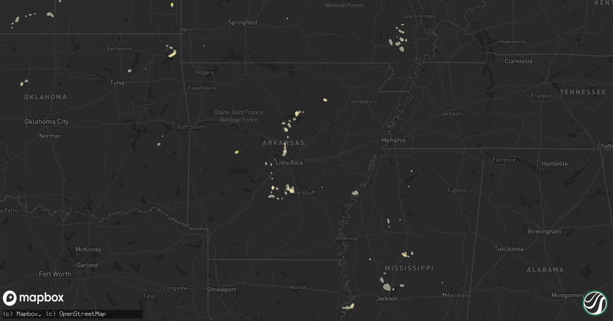
Hail Map in Arkansas on July 16, 2018
Get this storm
July 16 map
$229
one time, instant access
Download today. No call, no setup
Keep the $229
Bought the map and want the full workflow? Apply the entire $229 to a subscription within 7 days. None of it is wasted.
Every map, not just this one
This buys you this map. Subscription and you get every map we run, in the markets you choose from a few cities to whole states to nationwide. Plus real-time alerts the moment a storm fires.
Contact data
Name, contact info, occupancy, even credit band for addresses in the footprint. You go from where it hit to who to call.
Become the source they trust
Unlimited branding weather history reports on demand. You already have the documented answer ready for the property owner, and you are the one who showed up with it.
Property data and RoofTrace estimates
Pull up any address you have got, its value and the exact code rules for that jurisdiction, straight from One Click Code. Then RoofTrace estimates the squares, pitch, and roof value, priced the way you price.
Storm reports in Arkansas
Arkansas
| Date | Description |
|---|---|
| 07/16/20183:40 PM CDT | Trees down and blocking the highway along ar-46 south near cr-4670. Time estimated from radar. |
| 07/16/20183:35 PM CDT | Trees down along lowman road. |
| 07/16/20183:29 PM CDT | Spotter reports trees down near the intersection of lee springs road and providence road. |
| 07/16/20183:10 PM CDT | Tree damage reported near holcomb elementary. Photos relayed via broadcast media social media account. |
| 07/16/20182:40 PM CDT | Trees down and blocking the highway along ar-46 south near cr-4670. Time estimated from radar. |
| 07/16/20181:30 PM CDT | Trees were blown down near the north shore of lake conway. |
| 07/16/20187:39 AM CDT | At 1239 PM CDT, a severe thunderstorm was located over Guy, or 17 miles north of Conway, moving south at 5 mph. HAZARD...60 mph wind gusts and nickel size hail. SOURCE...Radar indicated. IMPACT...Expect damage to roofs, siding, and trees. Locations impacted include... Greenbrier... Guy... Damascus... Twin Groves... Woolly Hollow State Park... |
| 07/16/20186:52 AM CDT | At 1151 AM CDT, a severe thunderstorm was located near Greers Ferry, or 8 miles east of Fairfield Bay, moving east at 5 mph. HAZARD...60 mph wind gusts and quarter size hail. SOURCE...Radar indicated. IMPACT...Hail damage to vehicles is expected. Expect wind damage to roofs, siding, and trees. Locations impacted include... Heber Springs... Fairfield Bay... Greers Ferry... Concord... Higden... Edgemont... Prim... Dam Site Marina... Hill Creek Recreation Area... Ida... Brownsville... Drasco... Wolf Bayou... Narrows Marina... Brewer... Woodrow... Eden Isle... |
| 07/15/201811:55 PM CDT | At 454 PM CDT, a severe thunderstorm was located 7 miles southwest of Plainview in Yell County, or 7 miles south of Danville, moving northeast at 10 mph. HAZARD...60 mph wind gusts and quarter size hail. SOURCE...Radar indicated. IMPACT...Hail damage to vehicles is expected. Expect wind damage to roofs, siding, and trees. Locations impacted include... Danville... Plainview in Yell County... Corinth... Rover... Wing... Macedonia in Yell County... Kingston... Onyx... Fourche Mountain Recreation Are... Briggsville... Sunlight Bay Park... |
| 07/15/201810:29 PM CDT | At 328 PM CDT, a severe thunderstorm was located near Pine Bluff, moving southeast at 15 mph. HAZARD...60 mph wind gusts and quarter size hail. SOURCE...Radar indicated. IMPACT...Hail damage to vehicles is expected. Expect wind damage to roofs, siding, and trees. Locations impacted include... Pine Bluff... Star City... White Hall... Altheimer... Grady... Nebo... Feenyville... Cottondale... Whitefield... Linwood... Cane Creek State Park... Madding... Kedron... Warbritton... Woodville... Richardson... Pine Bluff Arsenal... Sulphur Springs... Wabbaseka... Tarry... |
| 07/15/201810:02 PM CDT | At 301 PM CDT, a severe thunderstorm was located near White Hall, or 11 miles west of Pine Bluff, moving northeast at 5 mph. HAZARD...60 mph wind gusts and quarter size hail. SOURCE...Radar indicated. IMPACT...Hail damage to vehicles is expected. Expect wind damage to roofs, siding, and trees. Locations impacted include... Pine Bluff... White Hall... Warbritton... Pine Bluff Arsenal... Sulphur Springs... Samples... Clear Lake... Hardin... Dexter... Prague... Jefferson... |
| 07/15/20189:32 PM CDT | At 232 PM CDT, a severe thunderstorm was located over Poyen, or 10 miles east of Malvern, moving northeast at 10 mph. HAZARD...60 mph wind gusts and quarter size hail. SOURCE...Radar indicated. IMPACT...Hail damage to vehicles is expected. Expect wind damage to roofs, siding, and trees. Locations impacted include... Traskwood... Tull... Prattsville... Poyen... Jenkins Ferry State Park... Thiel... Buie... Fenter... |
| 07/15/20188:51 PM CDT | At 151 PM CDT, a severe thunderstorm was located near Mayflower, or 7 miles northeast of Maumelle, moving southeast at 5 mph. HAZARD...60 mph wind gusts and penny size hail. SOURCE...Radar indicated. IMPACT...Expect damage to roofs, siding, and trees. Locations impacted include... North Little Rock... Sherwood... Jacksonville... Maumelle... Little Rock AFB... North Little Rock Airport... Mayflower... Burns Park... Gibson... Gravel Ridge... Morgan... Camp Robinson... Marche... Sylvan Hills... Oak Grove in Pulaski County... Olmstead... Amboy... Cammack Village... Cato... Saltillo... |
All States Impacted by Hail Map on July 16, 2018
Cities Impacted by Hail Map on July 16, 2018
- Thedford, NE
- Alma, NY
- Bolivar, NY
- New Raymer, CO
- Weldona, CO
- Fort Morgan, CO
- Chadron, NE
- Grant, NE
- Madrid, NE
- Phillipsburg, KS
- Cubero, NM
- Rexford, KS
- Colby, KS
- Newcastle, UT
- White Hall, AR
- Pine Bluff, AR
- Prairie View, KS
- Logan, KS
- Long Island, KS
- Harper, KS
- Attica, KS
- Danville, AR
- Rover, AR
- Wauneta, NE
- Merriman, NE
- Gordon, NE
- Hay Springs, NE
- Marsland, NE
- Hemingford, NE
- Paxton, NE
- Hampton, GA
- Casper, WY
- Elsie, NE
- Oxford, NE
- Custer, SD
- Ellsworth, NE
- Rushville, NE
- Hays, KS
- White River, SD
- Imperial, NE
- Transylvania, LA
- Bushnell, NE
- Sedona, AZ
- Thermopolis, WY
- Manville, WY
- Shawnee, WY
- Orleans, NE
- Hill City, SD
- Hermosa, SD
- Keystone, SD
- Fairburn, SD
- Meadville, PA
- Clare, MI
- Wood Lake, NE
- Johnstown, NE
- Valentine, NE
- Elsmere, NE
- Guy, AR
- Greenbrier, AR
- Quitman, AR
- Mitchell, NE
- Scottsbluff, NE
- Gering, NE
- Drasco, AR
- Stuttgart, AR
- Bentonia, MS
- Flora, MS
- Canton, MS
- Pass Christian, MS
- Gulfport, MS
- Kimball, NE
- Clarksdale, MS
- Crumrod, AR
- Oberlin, KS
- Holly, MI
- Fenton, MI
- Saint Francis, SD
- Mission, SD
- Tuthill, SD
- Culbertson, NE
- Palisade, NE
- Trenton, NE
- Hayes Center, NE
- Bunker Hill, KS
- Russell, KS
- Alpena, MI
- Bayard, NE
- Statesboro, GA
- Portal, GA
- Minneola, KS
- Plainville, KS
- Poplarville, MS
- Harrison, NE
- Crawford, NE
- Conway, AR
- North Little Rock, AR
- Mayflower, AR
- Gillette, WY
- Waldron, KS
- Claflin, KS
- Leakesville, MS
- Naponee, NE
- Stamford, NE
- Alma, NE
- Agra, KS
- Republican City, NE
- Bushton, KS
- Chase, KS
- Lyons, KS
- Ellinwood, KS
- Geneseo, KS
- Sheridan, AR
- Rosebud, SD
- Aurora, CO
- McCook, NE
- Herron, MI
- Hubbard Lake, MI
- Bertrand, NE
- Parmelee, SD
- Wood, SD
- Dalton, NE
- Potter, NE
- Oneill, NE
- Atkinson, NE
- Sidney, NE
- Gurley, NE
- Harrisburg, NE
- Glenrock, WY
- Girard, KS
- Ashby, NE
- Hyannis, NE
- Silver City, NM
- Wiggins, CO
- Holcomb, MS
- Protection, KS
- Atwood, KS
- Collinsville, OK
- Claremore, OK
- Padroni, CO
- Sumrall, MS
- Lumberton, MS
- Purvis, MS
- Eads, CO
- Naper, NE
- Edgemont, AR
- Higden, AR
- Walworth, NY
- Norton, KS
- Leola, AR
- Grove, OK
- Wyandotte, OK
- Mikado, MI
- Wright, WY
- Howard City, MI
- Douglas, WY
- Gothenburg, NE
- Hennessey, OK
- Herndon, KS
- Ashland, KS
- Paducah, KY
- Ledbetter, KY
- Wray, CO
- Holyoke, CO
- Kit Carson, CO
- Mountain Grove, MO
- Hotevilla, AZ
- Holyrood, KS
- Sulphur Rock, AR
- Concord, VA
- Lynchburg, VA
- Advance, MO
- Brownwood, MO
- Sturdivant, MO
- Zalma, MO
- Bloomfield, MO
- Batesville, AR
- Watkins, CO
- Deeth, NV
- Afton, OK
- Harbor Beach, MI
- Bingham, NE
- San Manuel, AZ
- Parker, CO
- Poyen, AR
- Vernon, FL
- Wallace, NE
- Crook, CO
- Lodgepole, NE
- Williams, AZ
- Grapevine, AR
- Buffalo, OK
- Halsey, NE
- Dix, NE
- Midland, MI
- Rhodes, MI
- Alliance, NE
- Kayenta, AZ
- Danbury, NE
- Indianola, NE
- Stratton, NE
- Selden, KS
- Nauvoo, AL
- Carbon Hill, AL
- Jackson, MS
- Madison, MS
- Ridgeland, MS
- Ellis, KS
- Vicksburg, MS
- Oakley, KS
- Patton, PA
- Fallentimber, PA
- Dysart, PA
- Ashville, PA
- Flinton, PA
- Glendale, UT
- Alton, UT
- Bell City, MO
- Salley, SC
- Woodston, KS
- Alton, KS
- Derby, KS
- Bosler, WY
- Sallis, MS
- Stapleton, NE
- Naples, FL
- Prattsville, AR
- Union, MS
- Richton, MS
- Essex, MO
- Darien, GA
- Brunswick, GA
- Townsend, GA
- Mansfield, PA
- Mainesburg, PA
- De Witt, NE
- Damascus, AR
- Bee Branch, AR
- Dudley, MO
- Puxico, MO
- Paron, AR
- Greenwood, MS
- Crown Point, IN
- Plymouth, NE
- Gorham, KS
- Danville, KS
- Martin, SD
- Cody, NE
- Meadville, MS
- Benton, AR
- Argonia, KS
- Champion, NE
- Linden, MI
- Howell, MI
- Hartland, MI
- White Lake, MI
- Davisburg, MI
- Highland, MI
- Enterprise, UT
- Miami, OK
- Linwood, MI
- Hardeeville, SC
- Kaycee, WY
- Glade, KS
- Bogalusa, LA
- Terreton, ID
- Hanover, NM
- Bayard, NM
- Traskwood, AR
- Hoisington, KS
- Lusk, WY
- Covington, LA
- Brookport, IL
- Lucedale, MS
- East Tawas, MI
- Kentwood, LA
- Salem, KY
- Dexter, MO
- Monument, KS
- West, MS
- Fairview, MO
- Wheatland, WY
- Stoneham, CO
- Red Oak, OK
- Mccurtain, OK
- Lander, WY
- Mobile, AL
- Kosciusko, MS
- Hope, MI
- Parma, MO
- Haswell, CO
- Philipp, MS
- Pinon, AZ
- Astor, FL
- Benton, MS
- Diamondhead, MS
- Amite, LA
- Lena, MS
- Brandon, MS
- Vilonia, AR
- Ubly, MI
- Holly Springs, MS
- Norcatur, KS
- Durant, MS
- Tallulah, LA
- Carthage, AR
- North Street, MI
- Fort Gratiot, MI
- Stone Ridge, NY
- Accord, NY
- Arthur, NE
- Edison, NE
- Beaver City, NE
- Lehigh Acres, FL
- Oscoda, MI
- Coalport, PA
- Booker, TX
- Alexander, AR
- Tawas City, MI
- Fairland, OK
- Beccaria, PA
- Appomattox, VA
- Stigler, OK
- Pryor, OK
- Folsom, LA
- Bush, LA
- Kilgore, NE
- Torrington, WY
- McLain, MS
- Castle Rock, CO
- Montello, NV
- Ludell, KS
- Waukomis, OK
- Bison, OK
- Eureka, NV
- Mountain View, OK
- Oxford, MS
- Louise, MS
- Silver City, MS
- Prim, AR
- La Crosse, VA
- Brodnax, VA
- Brooklet, GA
- Beaverton, MI
- Ruth, MI
- Minden City, MI
- Wellington, KS
- Canastota, NY
- Saint Francis, KS
- Chunky, MS
- Hickory, MS
- Maumelle, AR


