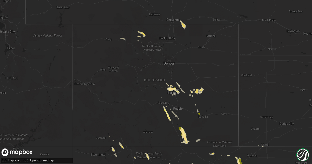
Hail Map in Colorado on July 16, 2014
Get this storm
July 16 map
$229
one time, instant access
Download today. No call, no setup
Keep the $229
Bought the map and want the full workflow? Apply the entire $229 to a subscription within 7 days. None of it is wasted.
Every map, not just this one
This buys you this map. Subscription and you get every map we run, in the markets you choose from a few cities to whole states to nationwide. Plus real-time alerts the moment a storm fires.
Contact data
Name, contact info, occupancy, even credit band for addresses in the footprint. You go from where it hit to who to call.
Become the source they trust
Unlimited branding weather history reports on demand. You already have the documented answer ready for the property owner, and you are the one who showed up with it.
Property data and RoofTrace estimates
Pull up any address you have got, its value and the exact code rules for that jurisdiction, straight from One Click Code. Then RoofTrace estimates the squares, pitch, and roof value, priced the way you price.
Storm reports in Colorado
Colorado
| Date | Description |
|---|---|
| 07/16/20144:20 PM CDT | A local report indicates 1.00 inch wind near 1 SSW RYE |
| 07/16/20143:59 PM CDT | A local report indicates 1.00 inch wind near SAN ISABEL |
| 07/16/20143:47 PM CDT | A local report indicates 1.75 inch wind near AIR FORCE ACADEMY |
| 07/15/20149:30 PM CDT | A local report indicates 2.00 inch wind near 3 ESE HOEHNE |
| 07/15/20149:30 PM CDT | A local report indicates 65 MPH wind near 3 ESE HOEHNE |
| 07/15/20148:13 PM CDT | 1 and a half miles north of strawberry park elementary school on county road 36. |
| 07/15/20147:24 PM CDT | 1 and a half miles north of strawberry park elementary school on county road 36. |
| 07/15/20147:15 PM CDT | In rye after severe storm passed. |
| 07/15/20147:14 PM CDT | A local report indicates 1.00 inch wind near 2 WNW ROCKY FORD |
Cities Impacted by Hail Map on July 16, 2014
- Gruver, TX
- Dumas, TX
- Evant, TX
- Colorado Springs, CO
- Elbert, CO
- Devol, OK
- Texhoma, OK
- Stratford, TX
- Big Spring, TX
- Ocate, NM
- Crowell, TX
- Paducah, TX
- Hereford, TX
- Vega, TX
- Cisco, TX
- Cross Plains, TX
- Cactus, TX
- Melvin, TX
- Tierra Amarilla, NM
- Coahoma, TX
- Rush, CO
- Hugo, CO
- Ramah, CO
- Model, CO
- Trinidad, CO
- Woodland Park, CO
- Dimmitt, TX
- Walters, OK
- Grandfield, OK
- Dulce, NM
- Wetmore, CO
- Beulah, CO
- Rye, CO
- Pueblo, CO
- Florence, CO
- Tyrone, OK
- Amarillo, TX
- Trinchera, CO
- Lampasas, TX
- Wildorado, TX
- Ordway, CO
- Ojo Caliente, NM
- Peyton, CO
- Fort Stockton, TX
- Steamboat Springs, CO
- Clayton, NM
- Cascade, CO
- Manitou Springs, CO
- Nazareth, TX
- Boise City, OK
- Dalhart, TX
- Usaf Academy, CO
- Karval, CO
- Walden, CO
- Bovina, TX
- Sunray, TX
- Loveland, OK
- Brownwood, TX
- Brady, TX
- Rising Star, TX
- Wichita Falls, TX
- Grover, CO
- Grenville, NM
- Gladstone, NM
- Cimarron, NM
- Des Moines, NM
- Carpenter, WY
- Moriarty, NM
- Haskell, TX
- Hamilton, TX
- Calhan, CO
- Yoder, CO
- Channing, TX
- Coalmont, CO
- Pagosa Springs, CO
- Albuquerque, NM
- Hugoton, KS
- Altus, OK
- Eden, TX
- Baird, TX
- Big Lake, TX
- Estancia, NM
- Avondale, CO
- Hereford, CO
- Bayfield, CO
- Branson, CO
- Cheyenne, WY
- Green Mountain Falls, CO
- Canon City, CO
- May, TX
- Seymour, TX
- Kirtland Afb, NM
- Briggsdale, CO
- Fountain, CO
- Hartley, TX
- Rocky Ford, CO


