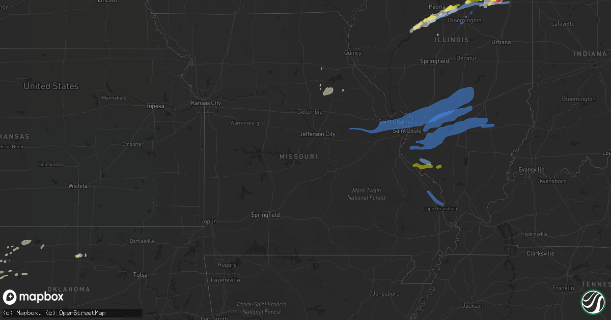
Hail Map in Missouri on July 15, 2020
Get this storm
July 15 map
$229
one time, instant access
Download today. No call, no setup
Keep the $229
Bought the map and want the full workflow? Apply the entire $229 to a subscription within 7 days. None of it is wasted.
Every map, not just this one
This buys you this map. Subscription and you get every map we run, in the markets you choose from a few cities to whole states to nationwide. Plus real-time alerts the moment a storm fires.
Contact data
Name, contact info, occupancy, even credit band for addresses in the footprint. You go from where it hit to who to call.
Become the source they trust
Unlimited branding weather history reports on demand. You already have the documented answer ready for the property owner, and you are the one who showed up with it.
Property data and RoofTrace estimates
Pull up any address you have got, its value and the exact code rules for that jurisdiction, straight from One Click Code. Then RoofTrace estimates the squares, pitch, and roof value, priced the way you price.
Storm reports in Missouri
Missouri
| Date | Description |
|---|---|
| 07/15/20204:55 PM CDT | Tree down across abbey ln. Time estimated from radar. |
| 07/15/20204:17 PM CDT | Tree snapped and fell on power lines. |
| 07/15/20204:14 PM CDT | Gas station canopy was blown over onto a vehicle at conoco gas station located at the corner of guthrie ave. And woodson rd. Vehicle sustained minor damage. Time estima |
| 07/15/20204:03 PM CDT | Tree down on a home. |
| 07/15/20204:02 PM CDT | Tree limbs down in the ballwin area. |
| 07/15/20204:00 PM CDT | 8in diameter tree limb fell on house and damaged shingles and gutter. |
| 07/15/20203:58 PM CDT | Power lines down across i64 westbound between boones crossing and chesterfield parkway. |
| 07/15/20203:55 PM CDT | Several trees down across the road and pea sized hail. |
| 07/15/20203:55 PM CDT | Report of wires down at the intersection of sommers rd and hwy n. |
| 07/15/20203:55 PM CDT | Trained spotter reported measured 70mph gust. |
| 07/15/20203:59 AM CDT | At 859 AM CDT, a severe thunderstorm was located near Santa Fe, moving east at 35 mph. HAZARD...60 mph wind gusts and quarter size hail. SOURCE...Radar indicated. IMPACT...Hail damage to vehicles is expected. Expect wind damage to roofs, siding, and trees. Locations impacted include... Mexico, Vandalia, Santa Fe, Perry, Laddonia, Frankford, Farber, Curryville, Spencerburg, New Hartford, Rush Hill and Vandiver. |
| 07/15/20202:40 AM CDT | At 740 PM CDT, a severe thunderstorm was located near Ava, or 11 miles east of Chester, moving southeast at 25 mph. HAZARD...70 mph wind gusts and nickel size hail. SOURCE...Radar indicated. IMPACT...Expect considerable tree damage. Damage is likely to mobile homes, roofs, and outbuildings. Locations impacted include... Murphysboro, Ava, Campbell Hill, Vergennes and Gorham. |
| 07/15/202012:35 AM CDT | At 535 PM CDT, a severe thunderstorm was located 9 miles south of New Design, moving east at 30 mph. HAZARD...60 mph wind gusts. SOURCE...Radar indicated. IMPACT...Expect damage to roofs, siding, and trees. Locations impacted include... Sparta, Red Bud, Steeleville, Percy, Coulterville, Tilden, Evansville, Baldwin, Eden, Preston, Blair, Prairie Du Rocher, Prairie, Ruma, Houston, Walsh, Renault, Ames and Kidd. |
| 07/14/202011:20 PM CDT | At 420 PM CDT, severe thunderstorms were located along a line extending from near Godfrey to near Antonia, moving east at 45 mph. HAZARD...60 mph wind gusts and nickel size hail. SOURCE...Radar indicated. IMPACT...Expect damage to roofs, siding, and trees. Locations impacted include... St. Louis, Belleville, Granite City, O'Fallon, Alton, East St. Louis, Collinsville, Edwardsville, Godfrey, Fairview Heights, Cahokia, Swansea, Glen Carbon, Shiloh, Wood River, Highland, Troy, Waterloo, Columbia and Bethalto.This includes the following highways... Interstate 70 in Illinois between exits 21 and 30. Interstate 55 in Illinois between exits 23 and 37. Interstate 64 in Illinois between exits 9 and 27.This also includes Horseshoe Lake State Park. |
| 07/14/202010:51 PM CDT | At 351 PM CDT, a severe thunderstorm was located over Weldon Spring Heights, moving east at 45 mph. HAZARD...60 mph wind gusts and nickel size hail. SOURCE...Public. IMPACT...Expect damage to roofs, siding, and trees. Locations impacted include... St. Louis, O'Fallon, St. Charles, St. Peters, Florissant, Chesterfield, Wildwood, University City, Ballwin, Wentzville, Kirkwood, Maryland Heights, Hazelwood, Webster Groves, Ferguson, Manchester, Creve Coeur, Overland, Clayton and Jennings.This includes the following highways... Interstate 44 in Missouri between exits 261 and 277. Interstate 70 in Missouri between exits 214 and 231.This also includes Babler Memorial State Park, Scott Joplin HistoricSite, Route 66 State Park, Castlewood State Park, Confluence StatePark, and First Missouri State Capitol Historic Site. |
| 07/14/202010:06 PM CDT | At 306 PM CDT, a severe thunderstorm was located over Treloar, moving east at 35 mph. HAZARD...60 mph wind gusts and quarter size hail. SOURCE...Radar indicated. IMPACT...Hail damage to vehicles is expected. Expect wind damage to roofs, siding, and trees. Locations impacted include... O'Fallon, Wentzville, Lake St. Louis, Washington, Dardenne Prairie, St. Paul, Marthasville, Innsbrook, New Melle, Josephville, Augusta, Treloar, Dutzow, Defiance, Foristell, Matson and Holstein.This includes Interstate 70 in Missouri between exits 208 and 214. |
| 07/14/20209:32 PM CDT | At 232 PM CDT, a severe thunderstorm was located over Swiss, moving northeast at 30 mph. HAZARD...60 mph wind gusts and quarter size hail. SOURCE...Radar indicated. IMPACT...Hail damage to vehicles is expected. Expect wind damage to roofs, siding, and trees. Locations impacted include... Hermann, New Haven, Swiss, Treloar, Gasconade, Berger and Holstein.This also includes Deutschheim Historic Site. |
All States Impacted by Hail Map on July 15, 2020
Cities Impacted by Hail Map on July 15, 2020
- Tucumcari, NM
- Logan, NM
- Barnesville, GA
- Valley, AL
- Forrest, IL
- Cullom, IL
- Fairbury, IL
- Chenoa, IL
- Chatsworth, IL
- Saunemin, IL
- Piper City, IL
- Pontiac, IL
- Newnan, GA
- Juliette, GA
- Macon, GA
- Roswell, NM
- Pittsview, AL
- Seale, AL
- Deer Trail, CO
- Agate, CO
- Evergreen, AL
- Eastman, GA
- Penrose, CO
- Pueblo, CO
- Deer Creek, IL
- Eureka, IL
- Washington, IL
- Calhan, CO
- Lehigh Acres, FL
- Fort Myers, FL
- El Paso, IL
- Gridley, IL
- San Jon, NM
- Bard, NM
- Raton, NM
- Sanderson, FL
- Hollywood, FL
- Lumberton, MS
- Vici, OK
- Fargo, GA
- Aline, OK
- Carmen, OK
- Dacoma, OK
- Waynoka, OK
- Fairview, OK
- Chester, OK
- Colorado Springs, CO
- Iron Ridge, WI
- Elbert, CO
- Kiowa, CO
- Conchas Dam, NM
- Lakeland, FL
- Larkspur, CO
- Ozark, AL
- Fort Rucker, AL
- Red Level, AL
- Fountain, CO
- Santa Rosa, NM
- Camargo, OK
- Groveland, IL
- Tremont, IL
- Pekin, IL
- Morton, IL
- Bush, LA
- Covington, LA
- Wetumpka, AL
- Gray, GA
- South Pekin, IL
- Manito, IL
- Green Valley, IL
- Kissimmee, FL
- Branson, CO
- Mexico, MO
- Santa Fe, MO
- Centralia, MO
- Thompson, MO
- Mutual, OK
- Clermont, FL
- Montverde, FL
- Griffin, GA
- Ponce De Leon, FL
- Defuniak Springs, FL
- Freeport, FL
- Shalimar, FL
- Folsom, NM
- Amarillo, TX
- Clayton, NM
- Rye, CO
- Walsenburg, CO
- Tallassee, AL
- Lagrange, GA
- Hogansville, GA
- Heidelberg, MS
- Seiling, OK
- Smiths Station, AL
- Phenix City, AL
- Willcox, AZ
- Needham, AL
- Waverly, AL
- Groveland, FL
- Madisonville, LA
- Arnett, OK
- Pulaski, MS
- Lake, MS
- Forest, MS
- Deer Park, AL
- Citronelle, AL
- McIntosh, AL
- Hiram, GA
- Dallas, GA
- Havana, IL
- Topeka, IL
- Lewistown, IL
- Laurel, MS
- The Rock, GA
- Thomaston, GA
- Yatesville, GA
- Bay Minette, AL
- Robertsdale, AL
- Beulah, CO
- Trementina, NM
- Opelika, AL
- Canadian, TX
- Zebulon, GA
- Norcross, GA
- Peachtree Corners, GA
- Duluth, GA
- Vossburg, MS
- Pachuta, MS
- Paulding, MS
- Moss Point, MS
- Laddonia, MO
- Farber, MO
- Alpena, MI
- Butler, AL
- Jachin, AL
- Lisman, AL
- Jet, OK
- Nash, OK
- Winter Haven, FL
- Vancleave, MS
- Mooreland, OK
- Powder Springs, GA
- Douglasville, GA
- Porterville, MS
- Goodfield, IL
- Congerville, IL
- Adrian, TX
- Newton, GA
- Red Rock, OK
- Rio Rico, AZ
- Briscoe, TX
- Panama City, FL
- Mosquero, NM
- Liverpool, IL
- Salem, AL
- Okeechobee, FL
- Daleville, AL
- Camilla, GA
- Okeene, OK
- Longdale, OK
- Florence, CO
- Williamson, GA
- Cochran, GA
- Hawkinsville, GA
- Cordele, GA
- Canon City, CO
- Secor, IL
- Collinsville, MS
- Meridian, MS
- Leakesville, MS
- Model, CO
- House, NM
- Alpharetta, GA
- Woodstock, GA
- Chipley, FL
- Milan, GA
- Punta Gorda, FL
- Enterprise, MS
- Billings, OK
- Brantley, AL
- Floyd, NM
- Kosciusko, MS
- Milton, FL
- Castleberry, AL
- Brewton, AL
- Holt, FL
- Baker, FL
- Ochopee, FL
- New Holland, IL
- Emden, IL
- Alva, OK
- McCool, MS
- Miami, TX
- Fayetteville, GA
- Hartsburg, IL
- Woodbury, GA
- Gay, GA
- Pensacola, FL
- Monroeville, AL
- Banks, AL
- Astatula, FL
- Samson, AL
- Shelbina, MO
- Paris, MO
- Springer, NM
- Myakka City, FL
- Sarasota, FL
- Rose Hill, MS
- Stinnett, TX
- Borger, TX
- Ariton, AL
- Fruitdale, AL
- Ashford, AL
- Laverne, OK
- Enterprise, AL
- Coffee Springs, AL
- Blakely, GA
- West Point, GA
- Niceville, FL
- Forsyth, GA
- Daphne, AL
- Jayess, MS
- Lake Butler, FL
- Columbus, GA
- Franklinton, LA
- Carlock, IL
- Danvers, IL
- Mackinaw, IL
- Forest City, IL
- East Peoria, IL
- Peoria, IL
- Lyons, GA
- Nashville, GA
- Sharon, OK
- Capitan, NM
- Woodward, OK
- Fort Supply, OK
- Chunchula, AL
- Eglin Afb, FL
- Chauncey, GA
- Waldo, FL
- Vernon, FL
- Crestview, FL
- Miami, FL
- Starkville, MS
- Alapaha, GA
- Cherokee, OK
- New Brockton, AL
- Taiban, NM
- Nara Visa, NM
- Hudson, IL
- Gilman, IL
- Onarga, IL
- Smithton, IL
- Albers, IL
- Addieville, IL
- Bartelso, IL
- Breese, IL
- Kinmundy, IL
- Saint Peter, IL
- Sandoval, IL
- New Baden, IL
- Lenzburg, IL
- Iuka, IL
- Odin, IL
- New Athens, IL
- Germantown, IL
- Okawville, IL
- Beckemeyer, IL
- Xenia, IL
- Waterloo, IL
- Lebanon, IL
- Vandalia, IL
- Louisville, IL
- Aviston, IL
- Mascoutah, IL
- Salem, IL
- Belleville, IL
- Saint Libory, IL
- Alma, IL
- Freeburg, IL
- Farina, IL
- Vernon, IL
- Centralia, IL
- Patoka, IL
- Marissa, IL
- Carlyle, IL
- Trenton, IL
- Greenville, IL
- Shobonier, IL
- Mulberry Grove, IL
- Pocahontas, IL
- Marine, IL
- Saint Elmo, IL
- Smithboro, IL
- Brownstown, IL
- Saint Jacob, IL
- Highland, IL
- Keyesport, IL
- Troy, IL
- Steeleville, IL
- Evansville, IL
- Baldwin, IL
- Walsh, IL
- Red Bud, IL
- Sparta, IL
- Shirley, IL
- Bloomington, IL
- Normal, IL
- Lexington, IL
- Towanda, IL
- Godfrey, IL
- Cowden, IL
- Litchfield, IL
- Walshville, IL
- Hamel, IL
- Collinsville, IL
- Taylor Springs, IL
- Worden, IL
- Saint Ann, MO
- Bethalto, IL
- Oconee, IL
- Roxana, IL
- Hazelwood, MO
- Augusta, MO
- Glen Carbon, IL
- East Alton, IL
- Bridgeton, MO
- Florissant, MO
- Ramsey, IL
- Witt, IL
- Nokomis, IL
- Maryland Heights, MO
- Lakewood, IL
- Herrick, IL
- Maryville, IL
- Edwardsville, IL
- Hillsboro, IL
- Berger, MO
- Bunker Hill, IL
- Madison, IL
- West Alton, MO
- Marthasville, MO
- Chesterfield, MO
- Donnellson, IL
- Lake Saint Louis, MO
- Wood River, IL
- Pana, IL
- Alhambra, IL
- Foristell, MO
- Fillmore, IL
- Granite City, IL
- Defiance, MO
- Shelbyville, IL
- Staunton, IL
- Hartford, IL
- Alton, IL
- Saint Peters, MO
- Hermann, MO
- Livingston, IL
- Irving, IL
- South Roxana, IL
- Tower Hill, IL
- Beecher City, IL
- Cottage Hills, IL
- Coffeen, IL
- O'Fallon, MO
- Moro, IL
- Saint Charles, MO
- Wentzville, MO
- Earth City, MO
- Panama, IL
- New Douglas, IL
- Saint Louis, MO
- Sorento, IL
- Bingham, IL
- Dorsey, IL
- Mount Olive, IL
- Oak Ridge, MO
- Perryville, MO
- Jackson, MO
- Friedheim, MO
- Cape Girardeau, MO
- Flora, IL
- Clay City, IL
- Peyton, CO
- Boone, CO
- La Junta, CO
- Evansville, IN
- Flanagan, IL
- Chester, IL
- Ellis Grove, IL
- Modoc, IL
- Prairie Du Rocher, IL
- Cutler, IL
- Percy, IL
- Fort Lauderdale, FL
- Des Moines, NM
- Capulin, NM
- Ramah, CO
- Bennett, CO
- Rockvale, CO


