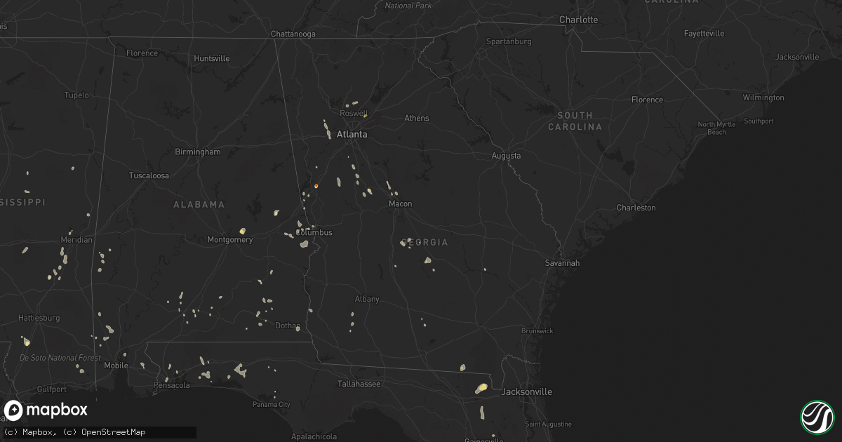
Hail Map in Georgia on July 15, 2020
Get this storm
July 15 map
$229
one time, instant access
Download today. No call, no setup
Keep the $229
Bought the map and want the full workflow? Apply the entire $229 to a subscription within 7 days. None of it is wasted.
Every map, not just this one
This buys you this map. Subscription and you get every map we run, in the markets you choose from a few cities to whole states to nationwide. Plus real-time alerts the moment a storm fires.
Contact data
Name, contact info, occupancy, even credit band for addresses in the footprint. You go from where it hit to who to call.
Become the source they trust
Unlimited branding weather history reports on demand. You already have the documented answer ready for the property owner, and you are the one who showed up with it.
Property data and RoofTrace estimates
Pull up any address you have got, its value and the exact code rules for that jurisdiction, straight from One Click Code. Then RoofTrace estimates the squares, pitch, and roof value, priced the way you price.
Storm reports in Georgia
Georgia
| Date | Description |
|---|---|
| 07/15/20206:40 PM CDT | 911 center reports multiple trees down at the intersection of newton and juliette roads. |
| 07/15/20206:30 PM CDT | 3 trees down on hwy 87 |
| 07/15/20206:14 PM CDT | 1 tree down @ east hwy 80 and maddox rd |
| 07/15/20206:12 PM CDT | 1 tree down at marion st and roberson ln |
| 07/15/20204:55 PM CDT | A tree was reported down on rahmah church rd. |
| 07/15/20204:52 PM CDT | Golf ball sized hail was reported on oak street. A truck windshield was reported shattered by the hail. |
| 07/15/20204:52 PM CDT | A tree was reported down on brent road. |
| 07/15/20204:51 PM CDT | Golf ball to hen-egg sized hail fell near mt zion church road. Car alarms were reported going off... A house window and a back patio table was reported damaged due to t |
| 07/15/20204:51 PM CDT | Walnut to golf ball sized hail fell around state route 403 and hines road. A car was reported dented with a cracked windshield. |
| 07/15/20204:09 PM CDT | Gdot reporting a large tree down across us hwy 1... Near toombs central |
| 07/15/20204:08 PM CDT | 1 tree down at scooter rue rd & hwy 257 |
| 07/15/20204:06 PM CDT | Multiple trees were reported down on scooter route branch. |
| 07/15/20204:06 PM CDT | Multiple trees and power lines were reported down near the intersection of highway 358 and highway 257. |
| 07/15/20204:06 PM CDT | 1 tree down at hwy 338 and rentz dexter rd |
| 07/15/20203:56 PM CDT | 3 trees reported down on and near cemetery rd... Northeast of downtown dexter |
| 07/15/20203:50 PM CDT | Quarter sized hail fell for approximately 2 minutes |
| 07/15/20203:48 PM CDT | Mostly nickel-sized hail with a few quarter-sized hail stone fell near berkeley lake on the sw side of duluth. A large oak tree was also down in the front yard of a hou |
| 07/15/20203:41 PM CDT | Public report of a a tree down on allenwood rd in ne fayetteville after strong thunderstorm wind gusts. |
| 07/15/20203:32 PM CDT | Power lines were reported down on mcdonough road and zoie court. |
| 07/15/20202:45 PM CDT | Multiple trees down on meadow brook drive... Including 2 medium-sized and 1 large-sized trees. |
| 07/15/20202:45 PM CDT | An esimated wind speed of 60 mph was measured from a rooftop. |
| 07/15/20202:43 PM CDT | A tree was reported down near the intersection of little brook drive and little brook lane. |
| 07/15/20202:42 PM CDT | Pine tree down blocking a lane on park creek ridge |
| 07/15/20202:33 AM CDT | At 733 PM EDT, a severe thunderstorm was located over Gay, or 8 miles northeast of Greenville, moving west at 15 mph. HAZARD...60 mph wind gusts and quarter size hail. SOURCE...Radar indicated. IMPACT...Hail damage to vehicles is expected. Expect wind damage to roofs, siding, and trees. Locations impacted include... Greenville, Woodbury, Luthersville, Lone Oak, Gay, Alvaton, Rocky Mount, Saint Marks, Odessadale, Imlac and Wooster. |
| 07/15/20202:30 AM CDT | At 730 PM EDT, a severe thunderstorm was located near Browndale, or near Hawkinsville, moving west at 15 mph. HAZARD...60 mph wind gusts and quarter size hail. SOURCE...Radar indicated. IMPACT...Hail damage to vehicles is expected. Expect wind damage to roofs, siding, and trees. Locations impacted include... Hawkinsville, Unadilla, Hayneville, Browndale, Sand Bed, Grovania, Mobley Crossing, Elko, Mock Springs, Grove Park, Wallace, Ocmulgee Public Fishing Area, Hartford, Pulaski State Prison, Klondike and Clinchfield. |
| 07/15/20202:18 AM CDT | At 718 PM EDT, a severe thunderstorm was located over Arkwright, or 10 miles northwest of Macon, moving west at 15 mph. HAZARD...60 mph wind gusts and quarter size hail. SOURCE...Radar indicated. IMPACT...Hail damage to vehicles is expected. Expect wind damage to roofs, siding, and trees. Locations impacted include... Macon, Forsyth, Payne City, Wesleyan, Bolingbroke, Arkwright, Dames Ferry, Collier, Juliette, Plant Scherer and Jarrell Plantation. |
| 07/15/20202:15 AM CDT | At 715 PM EDT, a severe thunderstorm was located near Union, or near Eastman, moving west at 15 mph. HAZARD...60 mph wind gusts and quarter size hail. SOURCE...Radar indicated. IMPACT...Hail damage to vehicles is expected. Expect wind damage to roofs, siding, and trees. Locations impacted include... Eastman, Abbeville, Milan, Rhine, Chauncey, Union, Jay Bird Springs, Five Points, Achord, Cedar Creek, Godwinsville and Ocmulgee Banks. |
| 07/15/20201:47 AM CDT | At 646 PM EDT, a severe thunderstorm was located over Rockledge, or 8 miles northwest of Soperton, moving northwest at 15 mph. HAZARD...60 mph wind gusts and quarter size hail. SOURCE...Radar indicated. IMPACT...Hail damage to vehicles is expected. Expect wind damage to roofs, siding, and trees. Locations impacted include... Dublin, Soperton, Wrightsville, East Dublin, Adrian, Spann, Lothair, Orland, Rockledge, Orianna, Norristown, Minter, Lovett, Brewton, Blackville and Scott. |
| 07/15/20201:31 AM CDT | At 631 PM EDT, severe thunderstorms were located along a line extending from near Griffin to Redbone Crossroads, moving northwest at 25 mph. HAZARD...60 mph wind gusts and quarter size hail. SOURCE...Radar indicated. IMPACT...Hail damage to vehicles is expected. Expect wind damage to roofs, siding, and trees. Locations impacted include... Griffin, Thomaston, Barnesville, Zebulon, Milner, Brooks, Molena, Williamson, Orchard Hill, Meansville, Aldora, Sunset Village, Lincoln Park, The Rock, East Griffin, Atwater, Hilltop, Hollonville, Sprewell Bluff State Park and Rover. |
| 07/15/202012:51 AM CDT | At 550 PM EDT, a severe thunderstorm was located over Louise, or near LaGrange, moving northwest at 5 mph. HAZARD...60 mph wind gusts and quarter size hail. SOURCE...Radar indicated. IMPACT...Hail damage to vehicles is expected. Expect wind damage to roofs, siding, and trees. Locations impacted include... LaGrange, Hogansville, Hillcrest, Louise, Mountville and Harrisonville. |
| 07/15/202012:33 AM CDT | At 533 PM EDT, a severe thunderstorm was located over Redbone, or near Barnesville, moving northwest at 10 mph. HAZARD...60 mph wind gusts and quarter size hail. SOURCE...Radar indicated. IMPACT...Hail damage to vehicles is expected. Expect wind damage to roofs, siding, and trees. Locations impacted include... Barnesville, Milner, Aldora, Redbone, Goggins, Piedmont and Johnstonville. |
| 07/15/202012:14 AM CDT | At 513 PM EDT, a severe thunderstorm was located over Chastain Memorial Park, or 8 miles north of Atlanta, moving northwest at 10 mph. HAZARD...60 mph wind gusts and quarter size hail. SOURCE...Radar indicated. IMPACT...Hail damage to vehicles is expected. Expect wind damage to roofs, siding, and trees. Locations impacted include... Atlanta, Marietta, Sandy Springs, Roswell, Smyrna, Dunwoody, Midtown, North Atlanta, North Druid Hills, Mount Bethel, Virginia Highland, Vinings, Piedmont Park, Bolton, Atlantic Station, Chastain Memorial Park, Little Five Points and Mableton. |
| 07/14/202011:59 PM CDT | At 458 PM EDT, a severe thunderstorm was located near English Eddy, or near Plant Hatch, moving northwest at 10 mph. HAZARD...60 mph wind gusts and quarter size hail. SOURCE...Radar indicated. IMPACT...Hail damage to vehicles is expected. Expect wind damage to roofs, siding, and trees. Locations impacted include... South Thompson, English Eddy, Center, Toombs Central, New Branch, Rock Springs, Cedar Crossing, Johnson Corner, McNatt Falls and Grays Landing. |
| 07/14/202011:57 PM CDT | At 457 PM EDT, a severe thunderstorm was located over Andersonville, or 8 miles northeast of Americus, moving northwest at 10 mph. HAZARD...60 mph wind gusts and quarter size hail. SOURCE...Radar indicated. IMPACT...Hail damage to vehicles is expected. Expect wind damage to roofs, siding, and trees. Locations impacted include... Americus, Andersonville, Andersonville National Historic, Clearview, Methvins, Bumphead, New Era, La Crosse, Pennington and Fountainville. |
| 07/14/202011:55 PM CDT | At 455 PM EDT, a severe thunderstorm was located over Dexter, or 10 miles southwest of Dublin, moving northwest at 10 mph. HAZARD...60 mph wind gusts and quarter size hail. SOURCE...Radar indicated. IMPACT...Hail damage to vehicles is expected. Expect wind damage to roofs, siding, and trees. Locations impacted include... Dublin, Dexter, Dudley, Cadwell, Rentz, Montrose and Harlow. |
| 07/14/202011:46 PM CDT | At 446 PM EDT, a severe thunderstorm was located over Berkeley Lake, or 10 miles west of Lawrenceville, moving northwest at 10 mph. HAZARD...60 mph wind gusts and quarter size hail. SOURCE...Radar indicated. IMPACT...Hail damage to vehicles is expected. Expect wind damage to roofs, siding, and trees. Locations impacted include... Roswell, Johns Creek, Alpharetta, Duluth, Norcross and Berkeley Lake. |
| 07/14/202011:41 PM CDT | At 440 PM EDT, a severe thunderstorm was located over Fayetteville, moving northwest at 10 mph. HAZARD...60 mph wind gusts and quarter size hail. SOURCE...Radar indicated. IMPACT...Hail damage to vehicles is expected. Expect wind damage to roofs, siding, and trees. Locations impacted include... Fayetteville, Jonesboro, Union City, Forest Park, Riverdale, College Park, Fairburn, Tyrone, Morrow, Bonanza, Sandy Creek and Irondale. |
| 07/14/202010:40 PM CDT | At 340 PM EDT, a severe thunderstorm was located near Lebanon, or 7 miles south of Canton, moving north at 15 mph. HAZARD...60 mph wind gusts and quarter size hail. SOURCE...Radar indicated. IMPACT...Hail damage to vehicles is expected. Expect wind damage to roofs, siding, and trees. Locations impacted include... Canton, Woodstock, Holly Springs, Buffington, Little River Landing, Hickory Flat, Lebanon, Union Hill and Bridgemill. |
| 07/14/20209:54 PM CDT | At 254 PM EDT, a severe thunderstorm was located over Geneva, or near Talbotton, moving northwest at 5 mph. HAZARD...60 mph wind gusts and quarter size hail. SOURCE...Radar indicated. IMPACT...Hail damage to vehicles is expected. Expect wind damage to roofs, siding, and trees. Locations impacted include... Talbotton, Junction City, Geneva, Marion Estates, Juniper, Olive Branch, Po Biddy Crossroads and Box Springs. |
All States Impacted by Hail Map on July 15, 2020
Cities Impacted by Hail Map on July 15, 2020
- Tucumcari, NM
- Logan, NM
- Barnesville, GA
- Valley, AL
- Forrest, IL
- Cullom, IL
- Fairbury, IL
- Chenoa, IL
- Chatsworth, IL
- Saunemin, IL
- Piper City, IL
- Pontiac, IL
- Newnan, GA
- Juliette, GA
- Macon, GA
- Roswell, NM
- Pittsview, AL
- Seale, AL
- Deer Trail, CO
- Agate, CO
- Evergreen, AL
- Eastman, GA
- Penrose, CO
- Pueblo, CO
- Deer Creek, IL
- Eureka, IL
- Washington, IL
- Calhan, CO
- Lehigh Acres, FL
- Fort Myers, FL
- El Paso, IL
- Gridley, IL
- San Jon, NM
- Bard, NM
- Raton, NM
- Sanderson, FL
- Hollywood, FL
- Lumberton, MS
- Vici, OK
- Fargo, GA
- Aline, OK
- Carmen, OK
- Dacoma, OK
- Waynoka, OK
- Fairview, OK
- Chester, OK
- Colorado Springs, CO
- Iron Ridge, WI
- Elbert, CO
- Kiowa, CO
- Conchas Dam, NM
- Lakeland, FL
- Larkspur, CO
- Ozark, AL
- Fort Rucker, AL
- Red Level, AL
- Fountain, CO
- Santa Rosa, NM
- Camargo, OK
- Groveland, IL
- Tremont, IL
- Pekin, IL
- Morton, IL
- Bush, LA
- Covington, LA
- Wetumpka, AL
- Gray, GA
- South Pekin, IL
- Manito, IL
- Green Valley, IL
- Kissimmee, FL
- Branson, CO
- Mexico, MO
- Santa Fe, MO
- Centralia, MO
- Thompson, MO
- Mutual, OK
- Clermont, FL
- Montverde, FL
- Griffin, GA
- Ponce De Leon, FL
- Defuniak Springs, FL
- Freeport, FL
- Shalimar, FL
- Folsom, NM
- Amarillo, TX
- Clayton, NM
- Rye, CO
- Walsenburg, CO
- Tallassee, AL
- Lagrange, GA
- Hogansville, GA
- Heidelberg, MS
- Seiling, OK
- Smiths Station, AL
- Phenix City, AL
- Willcox, AZ
- Needham, AL
- Waverly, AL
- Groveland, FL
- Madisonville, LA
- Arnett, OK
- Pulaski, MS
- Lake, MS
- Forest, MS
- Deer Park, AL
- Citronelle, AL
- McIntosh, AL
- Hiram, GA
- Dallas, GA
- Havana, IL
- Topeka, IL
- Lewistown, IL
- Laurel, MS
- The Rock, GA
- Thomaston, GA
- Yatesville, GA
- Bay Minette, AL
- Robertsdale, AL
- Beulah, CO
- Trementina, NM
- Opelika, AL
- Canadian, TX
- Zebulon, GA
- Norcross, GA
- Peachtree Corners, GA
- Duluth, GA
- Vossburg, MS
- Pachuta, MS
- Paulding, MS
- Moss Point, MS
- Laddonia, MO
- Farber, MO
- Alpena, MI
- Butler, AL
- Jachin, AL
- Lisman, AL
- Jet, OK
- Nash, OK
- Winter Haven, FL
- Vancleave, MS
- Mooreland, OK
- Powder Springs, GA
- Douglasville, GA
- Porterville, MS
- Goodfield, IL
- Congerville, IL
- Adrian, TX
- Newton, GA
- Red Rock, OK
- Rio Rico, AZ
- Briscoe, TX
- Panama City, FL
- Mosquero, NM
- Liverpool, IL
- Salem, AL
- Okeechobee, FL
- Daleville, AL
- Camilla, GA
- Okeene, OK
- Longdale, OK
- Florence, CO
- Williamson, GA
- Cochran, GA
- Hawkinsville, GA
- Cordele, GA
- Canon City, CO
- Secor, IL
- Collinsville, MS
- Meridian, MS
- Leakesville, MS
- Model, CO
- House, NM
- Alpharetta, GA
- Woodstock, GA
- Chipley, FL
- Milan, GA
- Punta Gorda, FL
- Enterprise, MS
- Billings, OK
- Brantley, AL
- Floyd, NM
- Kosciusko, MS
- Milton, FL
- Castleberry, AL
- Brewton, AL
- Holt, FL
- Baker, FL
- Ochopee, FL
- New Holland, IL
- Emden, IL
- Alva, OK
- McCool, MS
- Miami, TX
- Fayetteville, GA
- Hartsburg, IL
- Woodbury, GA
- Gay, GA
- Pensacola, FL
- Monroeville, AL
- Banks, AL
- Astatula, FL
- Samson, AL
- Shelbina, MO
- Paris, MO
- Springer, NM
- Myakka City, FL
- Sarasota, FL
- Rose Hill, MS
- Stinnett, TX
- Borger, TX
- Ariton, AL
- Fruitdale, AL
- Ashford, AL
- Laverne, OK
- Enterprise, AL
- Coffee Springs, AL
- Blakely, GA
- West Point, GA
- Niceville, FL
- Forsyth, GA
- Daphne, AL
- Jayess, MS
- Lake Butler, FL
- Columbus, GA
- Franklinton, LA
- Carlock, IL
- Danvers, IL
- Mackinaw, IL
- Forest City, IL
- East Peoria, IL
- Peoria, IL
- Lyons, GA
- Nashville, GA
- Sharon, OK
- Capitan, NM
- Woodward, OK
- Fort Supply, OK
- Chunchula, AL
- Eglin Afb, FL
- Chauncey, GA
- Waldo, FL
- Vernon, FL
- Crestview, FL
- Miami, FL
- Starkville, MS
- Alapaha, GA
- Cherokee, OK
- New Brockton, AL
- Taiban, NM
- Nara Visa, NM
- Hudson, IL
- Gilman, IL
- Onarga, IL
- Smithton, IL
- Albers, IL
- Addieville, IL
- Bartelso, IL
- Breese, IL
- Kinmundy, IL
- Saint Peter, IL
- Sandoval, IL
- New Baden, IL
- Lenzburg, IL
- Iuka, IL
- Odin, IL
- New Athens, IL
- Germantown, IL
- Okawville, IL
- Beckemeyer, IL
- Xenia, IL
- Waterloo, IL
- Lebanon, IL
- Vandalia, IL
- Louisville, IL
- Aviston, IL
- Mascoutah, IL
- Salem, IL
- Belleville, IL
- Saint Libory, IL
- Alma, IL
- Freeburg, IL
- Farina, IL
- Vernon, IL
- Centralia, IL
- Patoka, IL
- Marissa, IL
- Carlyle, IL
- Trenton, IL
- Greenville, IL
- Shobonier, IL
- Mulberry Grove, IL
- Pocahontas, IL
- Marine, IL
- Saint Elmo, IL
- Smithboro, IL
- Brownstown, IL
- Saint Jacob, IL
- Highland, IL
- Keyesport, IL
- Troy, IL
- Steeleville, IL
- Evansville, IL
- Baldwin, IL
- Walsh, IL
- Red Bud, IL
- Sparta, IL
- Shirley, IL
- Bloomington, IL
- Normal, IL
- Lexington, IL
- Towanda, IL
- Godfrey, IL
- Cowden, IL
- Litchfield, IL
- Walshville, IL
- Hamel, IL
- Collinsville, IL
- Taylor Springs, IL
- Worden, IL
- Saint Ann, MO
- Bethalto, IL
- Oconee, IL
- Roxana, IL
- Hazelwood, MO
- Augusta, MO
- Glen Carbon, IL
- East Alton, IL
- Bridgeton, MO
- Florissant, MO
- Ramsey, IL
- Witt, IL
- Nokomis, IL
- Maryland Heights, MO
- Lakewood, IL
- Herrick, IL
- Maryville, IL
- Edwardsville, IL
- Hillsboro, IL
- Berger, MO
- Bunker Hill, IL
- Madison, IL
- West Alton, MO
- Marthasville, MO
- Chesterfield, MO
- Donnellson, IL
- Lake Saint Louis, MO
- Wood River, IL
- Pana, IL
- Alhambra, IL
- Foristell, MO
- Fillmore, IL
- Granite City, IL
- Defiance, MO
- Shelbyville, IL
- Staunton, IL
- Hartford, IL
- Alton, IL
- Saint Peters, MO
- Hermann, MO
- Livingston, IL
- Irving, IL
- South Roxana, IL
- Tower Hill, IL
- Beecher City, IL
- Cottage Hills, IL
- Coffeen, IL
- O'Fallon, MO
- Moro, IL
- Saint Charles, MO
- Wentzville, MO
- Earth City, MO
- Panama, IL
- New Douglas, IL
- Saint Louis, MO
- Sorento, IL
- Bingham, IL
- Dorsey, IL
- Mount Olive, IL
- Oak Ridge, MO
- Perryville, MO
- Jackson, MO
- Friedheim, MO
- Cape Girardeau, MO
- Flora, IL
- Clay City, IL
- Peyton, CO
- Boone, CO
- La Junta, CO
- Evansville, IN
- Flanagan, IL
- Chester, IL
- Ellis Grove, IL
- Modoc, IL
- Prairie Du Rocher, IL
- Cutler, IL
- Percy, IL
- Fort Lauderdale, FL
- Des Moines, NM
- Capulin, NM
- Ramah, CO
- Bennett, CO
- Rockvale, CO


