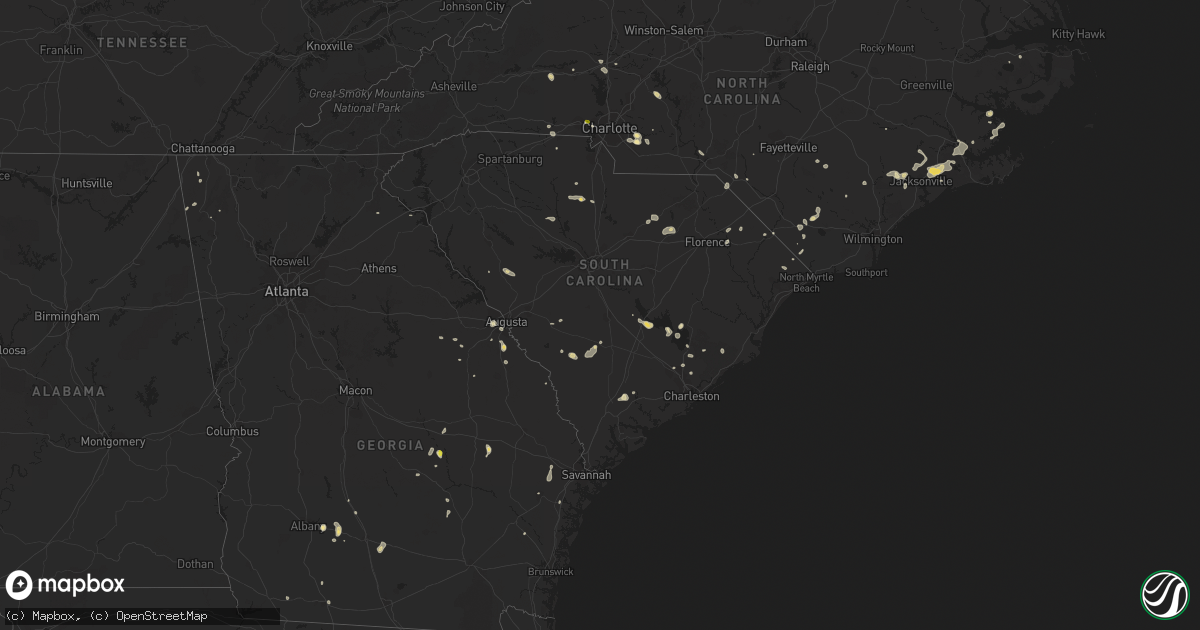
Hail Map in South Carolina on July 15, 2017
Get this storm
July 15 map
$229
one time, instant access
Download today. No call, no setup
Keep the $229
Bought the map and want the full workflow? Apply the entire $229 to a subscription within 7 days. None of it is wasted.
Every map, not just this one
This buys you this map. Subscription and you get every map we run, in the markets you choose from a few cities to whole states to nationwide. Plus real-time alerts the moment a storm fires.
Contact data
Name, contact info, occupancy, even credit band for addresses in the footprint. You go from where it hit to who to call.
Become the source they trust
Unlimited branding weather history reports on demand. You already have the documented answer ready for the property owner, and you are the one who showed up with it.
Property data and RoofTrace estimates
Pull up any address you have got, its value and the exact code rules for that jurisdiction, straight from One Click Code. Then RoofTrace estimates the squares, pitch, and roof value, priced the way you price.
Storm reports in South Carolina
South Carolina
| Date | Description |
|---|---|
| 07/15/20176:00 PM CDT | Edgefield county dispatch reported trees down along hwy 378. |
| 07/15/20175:18 PM CDT | Tree in roadway sc9. |
| 07/15/20175:15 PM CDT | Tree in roadway bounty acres road near shady grove church road |
| 07/15/20175:15 PM CDT | A tree was reported down on u.s. 301 s. The time was estimated based on radar data. |
| 07/15/20174:55 PM CDT | A local report indicates 58 MPH wind near MARLBORO CNTY JTPT |
| 07/15/20174:47 PM CDT | Sc hwy patrol reports a tree down along syrup mill rd near e peach rd. |
| 07/15/20174:45 PM CDT | Fairfield dispatch reported trees down on hwy 21 south at macedonia church rd. |
| 07/15/20174:33 PM CDT | Tree in roadway at the intersection of sc 269 and sc 215. |
| 07/15/20174:20 PM CDT | Tree in roadway wesley chapel rd near railroad tracks |
| 07/15/20174:15 PM CDT | A tree was reported in roadway near the intersection of w lydia highway and wesley chapel rd. The time was estimated based on radar data. |
| 07/15/20174:15 PM CDT | Fairfield dispatch reported trees down on hwy 21 at river rd. |
| 07/15/20174:14 PM CDT | Tree in roadway westover road 1/2 mile from sc151 |
| 07/15/20174:10 PM CDT | Fairfield county dispatch reports trees down along newberry rd near fairfield rd. |
| 07/15/20174:09 PM CDT | Fairfield dispatch reported trees down on heritage rd. |
| 07/15/20174:08 PM CDT | One tree was said to have fallen during the storm south of belton. |
| 07/15/20174:07 PM CDT | Schp reported a tree down at lakeside dr and shirley store rd |
| 07/15/20173:59 PM CDT | Trees down along firetower road. |
| 07/15/20173:55 PM CDT | Trees down on rambo road. |
| 07/15/20173:50 PM CDT | Tree in roadway us15. |
| 07/15/20172:50 PM CDT | Mill creek marina reported estmd wind gusts of 50-60 mph. |
| 07/15/20172:47 PM CDT | Trees down 9843 old number six highway. |
| 07/15/20172:40 PM CDT | Dept of highways reported a tree down on interstate 85 at mile marker 106 |
| 07/15/20172:40 PM CDT | Tree down on ballfield road in antioch community |
| 07/15/20172:19 PM CDT | Trees down on oak grove road. |
| 07/15/20171:52 PM CDT | Schp reported a tree down at jackson grove rd and walker rd |
| 07/15/20171:24 PM CDT | Schp reported a tree down on state park rd |
| 07/15/20171:07 PM CDT | Schp reported a tree down at keeler mill rd and jordan ebenezer rd |
All States Impacted by Hail Map on July 15, 2017
Cities Impacted by Hail Map on July 15, 2017
- East Troy, WI
- Elkhorn, WI
- Kewanee, IL
- Neponset, IL
- Annawan, IL
- Toulon, IL
- Sheffield, IL
- Coloma, WI
- Friendship, WI
- Kirbyville, TX
- Nathrop, CO
- Buena Vista, CO
- Maricopa, AZ
- Whitehall, WI
- Blair, WI
- Juda, WI
- Freeport, IL
- Dakota, IL
- Ridott, IL
- Mount Morris, IL
- Leaf River, IL
- Byron, IL
- Davis, IL
- Rock City, IL
- Oregon, IL
- German Valley, IL
- Monroe, WI
- Orangeville, IL
- Pecatonica, IL
- Cimarron, KS
- Viola, WI
- Viroqua, WI
- La Farge, WI
- Burnett, WI
- Seiling, OK
- Ozona, TX
- Dryden, TX
- Kanorado, KS
- Oakfield, WI
- Poulan, GA
- Sylvester, GA
- Washington Island, WI
- Eldorado, OK
- Quanah, TX
- Oakwood, OK
- Canton, OK
- Clintonville, WI
- Dousman, WI
- Gladstone, MI
- Escanaba, MI
- Cornell, MI
- Franklin, TN
- Fairview, TN
- Coolidge, AZ
- Cobbtown, GA
- Eagle, WI
- Aurora, NC
- Crown King, AZ
- Fletcher, OK
- Sedona, AZ
- Yukon, OK
- Berlin, WI
- Ripon, WI
- Brandon, WI
- Waupun, WI
- Goodman, WI
- Athelstane, WI
- Hockley, TX
- Enigma, GA
- Lenox, GA
- Tifton, GA
- Burlington, CO
- Fort Supply, OK
- Junction City, AR
- Walterboro, SC
- Albany, GA
- Hewitt, WI
- Auburndale, WI
- Marshfield, WI
- Gila Bend, AZ
- North Prairie, WI
- Nashotah, WI
- Hartland, WI
- Pewaukee, WI
- Oconomowoc, WI
- Delafield, WI
- Mukwonago, WI
- Okauchee, WI
- Garden City, KS
- Young, AZ
- Lamar, CO
- Crivitz, WI
- Hoxie, KS
- Monroe, NC
- Victoria, TX
- Norris, IL
- Brimfield, IL
- Glasford, IL
- La Fayette, IL
- Victoria, IL
- Galva, IL
- Canton, IL
- Dahinda, IL
- Trivoli, IL
- Laura, IL
- Yates City, IL
- Farmington, IL
- Williamsfield, IL
- Elmwood, IL
- Altona, IL
- Inez, TX
- Lake Geneva, WI
- Genoa City, WI
- Bamberg, SC
- Genoa, CO
- Pulaski, WI
- Wrightstown, WI
- Oneida, WI
- Black Creek, WI
- De Pere, WI
- Seymour, WI
- Green Bay, WI
- Sobieski, WI
- Bonduel, WI
- Kaukauna, WI
- Krakow, WI
- Greenleaf, WI
- Brillion, WI
- Prairie Du Sac, WI
- Reedsburg, WI
- Baraboo, WI
- North Freedom, WI
- Hico, TX
- Dublin, TX
- Appleton, WI
- Hortonville, WI
- Shiocton, WI
- Woodrow, CO
- Heart Butte, MT
- Arnett, OK
- Canadian, TX
- Waynesboro, GA
- Hephzibah, GA
- Tomball, TX
- Statesville, NC
- Prescott, AZ
- Edgefield, SC
- Creswell, NC
- Bayfield, CO
- Durango, CO
- Taloga, OK
- Moncks Corner, SC
- Reydon, OK
- Putnam, OK
- Custer City, OK
- Vici, OK
- Tabor City, NC
- Clarendon, NC
- Eads, CO
- Kit Carson, CO
- Arlington, CO
- Indian Trail, NC
- Mamou, LA
- Ville Platte, LA
- Oakdale, LA
- Randlett, OK
- Watertown, WI
- Dodge City, KS
- Marinette, WI
- Wisconsin Dells, WI
- Pineville, SC
- Duncan, OK
- Congress, AZ
- Mayer, AZ
- Westfield, WI
- Payson, AZ
- Olar, SC
- Ulmer, SC
- Barnwell, SC
- Eva, AL
- Hammon, OK
- Morristown, AZ
- Mustang, OK
- Collins, GA
- Ochlocknee, GA
- Meigs, GA
- Ninnekah, OK
- Boise City, OK
- New Bern, NC
- Purcell, OK
- London Mills, IL
- Maquon, IL
- Brussels, WI
- Rockingham, NC
- Wonder Lake, IL
- Fort Atkinson, WI
- Jefferson, WI
- Hartford, WI
- Theresa, WI
- Blanchard, OK
- Washington, OK
- Burlington, WI
- Ringwood, IL
- Hebron, IL
- Richmond, IL
- Whigham, GA
- Climax, GA
- New River, AZ
- Lindsay, OK
- Cross, SC
- Jetmore, KS
- Crawford, OK
- Monmouth, IL
- Kirkwood, IL
- Richlands, NC
- Chinquapin, NC
- Suring, WI
- Pound, WI
- Woodward, OK
- Amber, OK
- Chickasha, OK
- Fond Du Lac, WI
- Lomira, WI
- Brownsville, WI
- Campbellsport, WI
- Neosho, WI
- Benkelman, NE
- Kirkland, AZ
- Raeford, NC
- Longdale, OK
- Eutawville, SC
- Vance, SC
- Santee, SC
- Ashland, KS
- Minneola, KS
- Salome, AZ
- Palmyra, WI
- Helenville, WI
- Higgins, TX
- Pembine, WI
- New Glarus, WI
- Mount Horeb, WI
- Belleville, WI
- Blanchardville, WI
- Wells, MI
- Maysville, NC
- Summerville, SC
- Laverne, OK
- Arriba, CO
- Dodgeville, WI
- Akron, CO
- Yuma, CO
- Latta, SC
- McCormick, SC
- Blackstock, SC
- Winona, KS
- Sharon, OK
- Brookfield, WI
- Sussex, WI
- Lannon, WI
- Menomonee Falls, WI
- Sullivan, WI
- Rush Springs, OK
- Cameron, IL
- Jacksonville, NC
- Elloree, SC
- West Bend, WI
- Jackson, WI
- Fontana, WI
- Walworth, WI
- Black Canyon City, AZ
- Ixonia, WI
- Horicon, WI
- Iron Ridge, WI
- Hickory, NC
- Connelly Springs, NC
- Evansville, WI
- Spurger, TX
- Nichols, SC
- Fair Bluff, NC
- Lake Mills, WI
- Waterloo, WI
- Louisville, GA
- Cibolo, TX
- Marion, TX
- Seguin, TX
- Schertz, TX
- Saint Hedwig, TX
- Yemassee, SC
- Chester, SC
- Cheyenne, OK
- Beloit, WI
- Augusta, GA
- Thomas, OK
- New London, WI
- Miami, TX
- Oklahoma City, OK
- Huntsville, TX
- Grantsboro, NC
- Maysville, OK
- Lowell, NC
- Gastonia, NC
- Hustisford, WI
- Readstown, WI
- Oakley, KS
- Colby, KS
- Durham, OK
- Sahuarita, AZ
- Cortez, CO
- Warrens, WI
- Marion, SC
- Wickenburg, AZ
- Hartsville, SC
- Bishopville, SC
- Protection, KS
- Prescott Valley, AZ
- Alford, FL
- Cottondale, FL
- Stillman Valley, IL
- Ashburn, GA
- Conway, SC
- Loris, SC
- Gold Hill, NC
- Ensign, KS
- Marshville, NC
- Bethune, SC
- Somerville, AL
- Autryville, NC
- Roseboro, NC
- Plymouth, WI
- Cascade, WI
- Grover, NC
- Shelby, NC
- Clinton, OK
- Superior, AZ
- Columbia, NC
- Columbus, WI
- Arena, WI
- Barneveld, WI
- Omro, WI
- Oshkosh, WI
- Bear Creek, WI
- Alma, GA
- Hazlehurst, GA
- Rock Springs, WI
- Seven Springs, NC
- Stephenson, MI
- Fredonia, WI
- Random Lake, WI
- Kewaskum, WI
- Adell, WI
- Smyrna, SC
- Oquawka, IL
- Edna, TX
- South Beloit, IL
- Caledonia, IL
- Cochise, AZ
- Leedey, OK
- Camargo, OK
- Chadbourn, NC
- Whiteville, NC
- Mount Calvary, WI
- Cross Plains, WI
- Richfield, WI
- Daggett, MI
- Clarkton, NC
- Florence, AZ
- Delavan, WI
- El Dorado, AR
- Monticello, WI
- Briggsville, WI
- Oxford, WI
- Avoca, WI
- Laurinburg, NC
- McColl, SC
- Glenwood, GA
- McRae Helena, GA
- Lake Waccamaw, NC
- Council, NC
- Allenton, WI
- Johnson Creek, WI
- Ashippun, WI
- Rubicon, WI
- Juneau, WI
- Whitewater, WI
- Darlington, WI
- Soldiers Grove, WI
- Winslow, AZ
- Norman, OK
- Healy, KS
- Scott City, KS
- Loganville, WI
- Montello, WI
- Chino Valley, AZ
- Sycamore, GA
- Moody, TX
- Peoria, AZ
- Bird City, KS
- Alex, OK
- Sayre, OK
- Kennard, TX
- Maxton, NC
- Troutman, NC
- Stapleton, GA
- Gibson, GA
- Wallace, NC
- Springfield, WI
- Woodstock, IL
- Harvard, IL
- Fowler, KS
- Eleva, WI
- Davis Junction, IL
- Monroe Center, IL
- Rochelle, IL
- Lindenwood, IL
- Rockford, IL
- Esmond, IL
- Kirkland, IL
- Cherry Valley, IL
- Oconto Falls, WI
- Lena, WI
- Coleman, WI
- Abingdon, IL
- Menominee, MI
- Wayne, OK
- Ehrhardt, SC
- Warrenton, GA
- Chickamauga, GA
- Lavonia, GA
- Rosendale, WI
- Eldorado, WI
- Pickett, WI
- Avera, GA
- Steward, IL
- Belvidere, IL
- Chana, IL
- Shawano, WI
- Poy Sippi, WI
- Gillett, WI
- Armuchee, GA
- Valley Mills, TX
- Clifton, TX
- Hubert, NC
- Maple Hill, NC
- Amberg, WI
- Slinger, WI
- Arapaho, OK
- Newton, TX
- Spragueville, IA
- Bellevue, IA
- Ridgeway, WI
- Mazomanie, WI
- Jesup, GA
- Markesan, WI
- Agate, CO
- Osseo, WI
- Weskan, KS
- Tonopah, AZ
- Chattahoochee, FL
- Green Lake, WI
- Redgranite, WI
- Leoti, KS
- Milton, WI
- Conover, NC
- La Harpe, IL
- Mountain View, OK
- Buckeye, AZ
- Matthews, NC
- Rexford, KS
- Beaver Dam, WI
- Montezuma, KS
- Stronghurst, IL
- Lomax, IL
- Blacksburg, SC
- Manawa, WI
- Fargo, OK
- McGregor, TX
- Oglesby, TX
- Oracle, AZ
- Southard, OK
- Watonga, OK
- Okeene, OK
- Rockland, WI
- Bayboro, NC
- Hobucken, NC
- Merritt, NC
- Sturgeon Bay, WI
- Menlo, GA
- Mosinee, WI
- Valier, MT
- Selden, KS
- Thomasville, GA
- Janesville, WI
- Williston, SC
- Schlater, MS
- Goose Creek, SC
- Cuba, IL
- Lewistown, IL
- Loretto, TN
- Belmont, NC
- Green Pond, SC
- Packwaukee, WI
- Oakboro, NC
- Cedar Bluff, AL
- Richfield, NC
- Blue Mounds, WI
- Midway, GA
- Princeton, WI
- Newberry, SC
- Whitmire, SC
- Pomaria, SC
- Bradley, OK
- Anaconda, MT
- Pasadena, TX
- Galena Park, TX
- Houston, TX
- Channelview, TX
- Minco, OK
- Rio, WI
- Harrells, NC
- Ivanhoe, NC
- Summerville, GA
- Mineral Point, WI
- Jamestown, SC
- Stratton, NE
- Buffalo, OK
- La Fayette, GA
- Alamo, GA
- Mountain, WI
- Sylvania, GA
- Hallsboro, NC
- Vernon, TX
- Cassatt, SC
- Grovetown, GA
- Toccoa, GA
- Gould, OK
- Soperton, GA
- Adrian, GA
- Rockledge, GA
- Fort Stewart, GA
- Ellabell, GA
- Rock, MI
- Loves Park, IL
- Holcomb, IL
- Machesney Park, IL
- Malta, IL
- Kingston, IL
- Garland, NC
- Hubertus, WI
- Colgate, WI
- Germantown, WI
- Springfield, TN
- Bonneau, SC
- Cordesville, SC
- Chaseburg, WI
- Westby, WI
- Reeseville, WI
- Willard, NC
- Mchenry, IL


