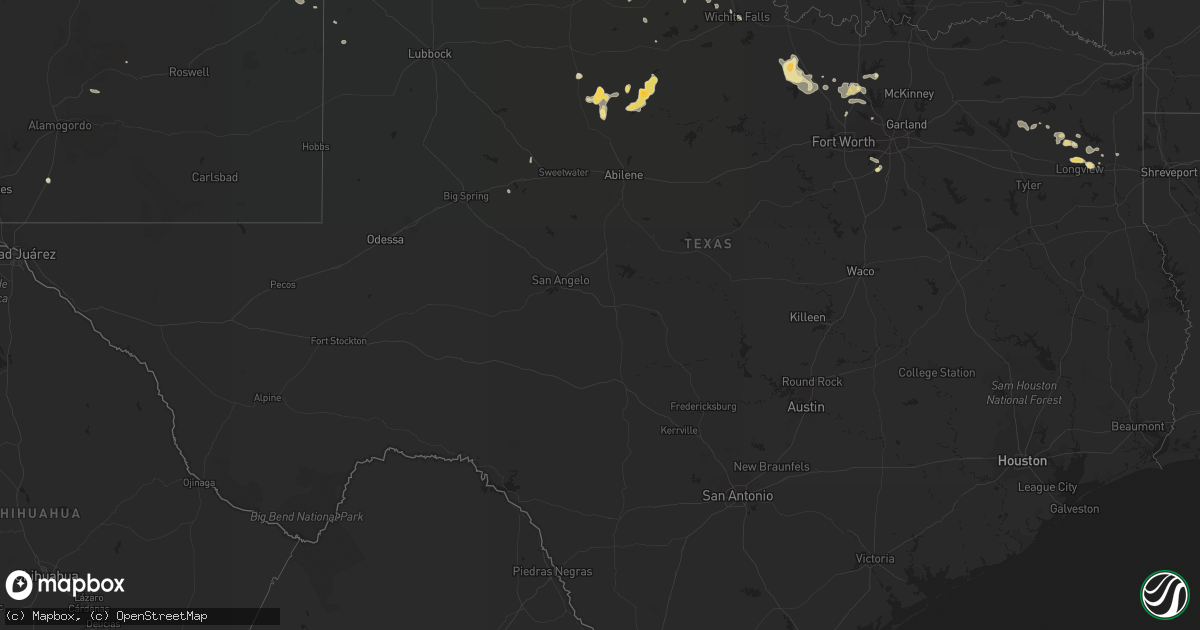
Hail Map in Texas on July 15, 2016
Get this storm
July 15 map
$229
one time, instant access
Download today. No call, no setup
Keep the $229
Bought the map and want the full workflow? Apply the entire $229 to a subscription within 7 days. None of it is wasted.
Every map, not just this one
This buys you this map. Subscription and you get every map we run, in the markets you choose from a few cities to whole states to nationwide. Plus real-time alerts the moment a storm fires.
Contact data
Name, contact info, occupancy, even credit band for addresses in the footprint. You go from where it hit to who to call.
Become the source they trust
Unlimited branding weather history reports on demand. You already have the documented answer ready for the property owner, and you are the one who showed up with it.
Property data and RoofTrace estimates
Pull up any address you have got, its value and the exact code rules for that jurisdiction, straight from One Click Code. Then RoofTrace estimates the squares, pitch, and roof value, priced the way you price.
Storm reports in Texas
Texas
| Date | Description |
|---|---|
| 07/15/20165:45 PM CDT | Tree on home fair street. Also w.pincrest closed due to downed trees and lines across road. |
| 07/15/20165:40 PM CDT | Several trees reported down in jefferson on wilson and mlk roads. |
| 07/15/20165:20 PM CDT | Public post photo of quarter size hail in hallsville on kltv facebook page. |
| 07/15/20165:02 PM CDT | Hail between longview and judson... High wind ripped lattice off |
| 07/15/20164:38 PM CDT | Tree down astor raod and fm 2796 |
| 07/15/20164:36 PM CDT | Tree down 726 north of 259 just south of ore city |
| 07/15/20164:20 PM CDT | Shop house was destroyed on gardenia road |
| 07/15/20163:54 PM CDT | Numerous trees and power lines down across city |
| 07/15/20163:42 PM CDT | Numerous trees and powerlines down across western part of county |
| 07/15/20163:10 PM CDT | Tree down on hwy 11 west |
| 07/15/201610:57 AM CDT | Childress asos |
| 07/15/20169:22 AM CDT | Delayed report---trees down at the intersections of legacy and chase oaks---parks boulevard and mira vista---custer and spring creek---midway and parker. |
| 07/15/20168:45 AM CDT | Over 60 mph winds reported se of ponder and sw of denton. Patio furniture being blown down in the robson ranch area. |
| 07/15/20168:10 AM CDT | Estimated 60 mph winds and some urban flooding on mulberry street in decatur. |
| 07/15/20167:15 AM CDT | Tree down in sunset on picket run road near highway 101 |
| 07/14/201611:05 PM CDT | West texas mesonet report |
| 07/14/201610:57 PM CDT | Childress asos |
| 07/14/201610:50 PM CDT | Childress asos |
| 07/14/201610:10 PM CDT | Roof removed from barn |
| 07/14/20169:59 PM CDT | Late report received. |
| 07/14/20169:45 PM CDT | West texas mesonet report |
| 07/14/20169:29 PM CDT | Late report...68 mph thunderstorm wind gust received from broadcast media |
| 07/14/20168:54 PM CDT | Late report...visibility reduced to less than a mile in sideways blowing rain. Time estimated from doppler radar. |
| 07/14/20168:45 PM CDT | 4 inch diameter tree limb was downed. |
| 07/14/20168:39 PM CDT | A local report indicates 66 MPH wind near 8 E LORA |
| 07/14/20168:34 PM CDT | A local report indicates 64 MPH wind near 2 NE LAKE TANGLEWOOD |
| 07/14/20168:07 PM CDT | A local report indicates 62 MPH wind near 1 S BORGER |
| 07/14/20167:24 PM CDT | A local report indicates 59 MPH wind near 7 ENE VALLEY DE ORO |
| 07/14/20167:15 PM CDT | A local report indicates 70 MPH wind near 3 ENE PERRYTON |
| 07/14/20167:07 PM CDT | A local report indicates 61 MPH wind near 11 WNW BOOTLEG |
| 07/14/20167:00 PM CDT | A local report indicates 60 MPH wind near 11 WNW BOOTLEG |
All States Impacted by Hail Map on July 15, 2016
Cities Impacted by Hail Map on July 15, 2016
- Taloga, OK
- Arnett, OK
- Butler, OK
- Leedey, OK
- Camargo, OK
- Vici, OK
- Sunray, TX
- Stratford, TX
- Manila, AR
- Erwin, NC
- Mclean, TX
- Hawesville, KY
- Pomaria, SC
- Chesapeake, VA
- Moyock, NC
- Cordesville, SC
- Bonneau, SC
- Moncks Corner, SC
- Clovis, NM
- Cambridge, NE
- Bartley, NE
- Elizabethtown, NC
- Syracuse, KS
- Denver, CO
- Englewood, CO
- Littleton, CO
- Aurora, CO
- Haskell, TX
- Coward, SC
- Olanta, SC
- Scranton, SC
- Jamestown, MO
- Tampa, FL
- Junction, IL
- Equality, IL
- Wilsall, MT
- Sheridan Lake, CO
- Arapahoe, CO
- Shamrock, TX
- Tavares, FL
- Mount Dora, FL
- Rule, TX
- Rogers, NM
- Longview, TX
- Central City, KY
- Henning, TN
- Osceola, AR
- Wilson, AR
- Conway, SC
- Myrtle Beach, SC
- Hartsville, SC
- Patrick, SC
- Electra, TX
- Harrold, TX
- San Jon, NM
- Turkey, NC
- Warsaw, NC
- Magnolia, NC
- Cut Bank, MT
- Enfield, NC
- Decatur, TX
- Georgetown, SC
- Curtis, NE
- Wellfleet, NE
- Maywood, NE
- Hammon, OK
- Whitewater, MO
- Chaffee, MO
- Astatula, FL
- Groveland, FL
- Clermont, FL
- Howey In The Hills, FL
- Weskan, KS
- Tribune, KS
- Tryon, NE
- Hershey, NE
- Stapleton, NE
- North Platte, NE
- Sutherland, NE
- Paxton, NE
- Jacksboro, TX
- Bowie, TX
- Sunset, TX
- Chico, TX
- Doniphan, MO
- Cheraw, SC
- Lilesville, NC
- Wallace, SC
- Morven, NC
- Wadesboro, NC
- Chesterfield, SC
- Alamogordo, NM
- Weinert, TX
- Spring Hope, NC
- Zebulon, NC
- Middlesex, NC
- Bunn, NC
- Louisburg, NC
- Cumberland, OH
- Blue Rock, OH
- Caldwell, OH
- Mcconnelsville, OH
- Redfield, AR
- Black, MO
- Clarendon, NC
- Nakina, NC
- Tabor City, NC
- Guysville, OH
- Athens, OH
- Cutler, OH
- Elon, NC
- Whitsett, NC
- Liberty, NC
- Burlington, NC
- Julian, NC
- Millington, TN
- Arlington, TN
- Atoka, TN
- Brighton, TN
- Cozad, NE
- Gothenburg, NE
- Brady, NE
- Tipton, OK
- Stamford, TX
- Throckmorton, TX
- Skellytown, TX
- Canyon, TX
- Columbia, LA
- Senatobia, MS
- Coldwater, MS
- Zuni, VA
- Malden, MO
- Campbell, MO
- Circleville, OH
- Aspermont, TX
- Old Glory, TX
- Whitakers, NC
- Statesboro, GA
- Moccasin, MT
- Kramer, ND
- Bottineau, ND
- Souris, ND
- Hamlet, NC
- Puxico, MO
- Scott City, KS
- Garden City, KS
- Coolville, OH
- Great Falls, MT
- Cascade, MT
- Elizabeth, CO
- Franktown, CO
- Parker, CO
- Panhandle, TX
- Groom, TX
- White Deer, TX
- Benton, AR
- Memphis, TN
- Whitman, NE
- Hermosa, SD
- Rapid City, SD
- Caputa, SD
- Hill City, SD
- Reed Point, MT
- Columbus, MT
- Big Timber, MT
- Elberon, VA
- Surry, VA
- Wakefield, VA
- Smithfield, VA
- Ivor, VA
- Elk City, OK
- Farwell, TX
- Oconto, NE
- Amarillo, TX
- Centerville, MO
- Dumas, TX
- Jonesville, LA
- Harrisonburg, LA
- Dunn, NC
- Linden, NC
- Pageland, SC
- Mount Croghan, SC
- Jefferson, SC
- Gilmer, TX
- Pampa, TX
- Hollis, OK
- Gould, OK
- Willow, OK
- Erick, OK
- Wellington, TX
- Dodson, TX
- Mangum, OK
- Vinson, OK
- Cairo, IL
- Burlington, CO
- Augusta, MT
- Paducah, TX
- Hilliard, FL
- Callahan, FL
- Wolf Creek, MT
- Childress, TX
- Denton, TX
- Marble Hill, MO
- Portales, NM
- Las Vegas, NM
- Montezuma, NM
- Shawmut, MT
- Campo, CO
- Hardinsburg, KY
- Live Oak, FL
- Coushatta, LA
- Darlington, SC
- Monterey, LA
- Acme, LA
- Canaan, IN
- Butlerville, IN
- Madison, IN
- Dupont, IN
- Quanah, TX
- Carmi, IL
- New Haven, IL
- Camden, SC
- Cassatt, SC
- Bishopville, SC
- Paron, AR
- Fayetteville, NC
- Sarah, MS
- Crenshaw, MS
- Jetmore, KS
- Dodge City, KS
- Hampton, FL
- Starke, FL
- Pink Hill, NC
- Beulaville, NC
- Ashland, KS
- Clarendon, TX
- Claude, TX
- Mullen, NE
- Grayson, LA
- Sikes, LA
- Effingham, SC
- Timmonsville, SC
- Lesterville, MO
- Walsh, CO
- Birdseye, IN
- Bristow, IN
- Hobart, OK
- Healy, KS
- Sweet Grass, MT
- Sunburst, MT
- Spearman, TX
- Sharon, SC
- McConnells, SC
- McArthur, OH
- Creola, OH
- New Plymouth, OH
- Zaleski, OH
- Ozark, AL
- Ariton, AL
- Warsaw, KY
- Florence, IN
- Patriot, IN
- Muleshoe, TX
- Lakeview, TX
- Cordell, OK
- Kenansville, NC
- Holly, CO
- Fort Mill, SC
- Rock Hill, SC
- Happy, TX
- Minneola, KS
- Holcomb, KS
- Manhattan, MT
- Chatham, LA
- Ridgway, IL
- Quitaque, TX
- Kit Carson, CO
- Fishtail, MT
- Nye, MT
- McLeod, MT
- Absarokee, MT
- Clinton, NC
- Fort Supply, OK
- Kendall, KS
- Cheyenne Wells, CO
- Coolidge, KS
- Natchitoches, LA
- Society Hill, SC
- Denton, MT
- Sulphur, LA
- Vinton, LA
- Blair, SC
- Jenkinsville, SC
- Midlothian, TX
- Granite, OK
- Hallsville, TX
- Bell City, MO
- Pembroke, GA
- Olla, LA
- Trout, LA
- New Bern, NC
- Bucklin, KS
- Wichita Falls, TX
- Zalma, MO
- Diana, TX
- Lockney, TX
- Silverton, TX
- Flomot, TX
- Hensley, AR
- Sheridan, AR
- Westbrook, TX
- Colorado City, TX
- Briscoe, TX
- Canadian, TX
- Chandler, IN
- Elberfeld, IN
- Cadiz, KY
- Rich Square, NC
- Bladenboro, NC
- Turkey, TX
- Marshall, TX
- Blackstone, VA
- Memphis, TX
- Hereford, TX
- Broadview, NM
- McKenney, VA
- Saint Meinrad, IN
- Ferdinand, IN
- Wake Forest, NC
- Rolesville, NC
- Dickens, NE
- Duke, OK
- Jacksonville, FL
- Stover, MO
- Farnam, NE
- Camden, TN
- North, SC
- Halifax, NC
- Altus, OK
- Kyle, SD
- Frederick, OK
- Lamar, IN
- Santa Claus, IN
- Huntingburg, IN
- Dale, IN
- English, IN
- Saint Croix, IN
- Dubois, IN
- Jasper, IN
- Evanston, IN
- Taswell, IN
- Eckerty, IN
- Celestine, IN
- Loomis, NE
- Beaver City, NE
- Stamford, NE
- Ore City, TX
- Leopold, MO
- Sargent, NE
- Broken Bow, NE
- Ponder, TX
- Justin, TX
- Krum, TX
- Hawthorne, FL
- Almena, KS
- Long Island, KS
- Winnsboro, SC
- Fremont, MO
- Arthur, NE
- Stoutsville, OH
- Tarlton, OH
- Laurelville, OH
- Amanda, OH
- Pierceville, KS
- Phillipsburg, KS
- Trenton, FL
- Johnson, KS
- Mountain View, OK
- Carnegie, OK
- Gotebo, OK
- Currituck, NC
- Shawboro, NC
- Roseboro, NC
- Warsaw, MO
- Whigham, GA
- Water Valley, MS
- Coffeeville, MS
- Punta Gorda, FL
- Lancaster, OH
- Evansville, IN
- Center Point, LA
- Deville, LA
- Vidalia, LA
- Evergreen, NC
- Agra, KS
- Ahoskie, NC
- Bethune, CO
- Turbeville, SC
- Lugoff, SC
- Kingsland, GA
- Harleton, TX
- Browning, MT
- Mescalero, NM
- Pleasanton, NE
- Virginia Beach, VA
- Rocky, OK
- Blair, OK
- Orleans, NE
- Manning, SC
- Godwin, NC
- Wade, NC
- Corapeake, NC
- Sunbury, NC
- Lawrenceburg, KY
- McKenzie, TN
- Henry, TN
- Carter, MT
- Mount Vernon, IN
- Madison, FL
- Chillicothe, TX
- Vernon, TX
- Eldorado, OK
- Bridgeport, TX
- Alvord, TX
- Newberry, FL
- Winnsboro, TX
- Pine Ridge, SD
- Smithland, KY
- Ledbetter, KY
- Brookport, IL
- Alma, NE
- Kensington, KS
- Maxwell, NE
- Williamsburg, OH
- Cactus, TX
- Arcadia, LA
- De Witt, AR
- Paradise, TX
- Kelly, LA
- Port Charlotte, FL
- North Port, FL
- Aurora, NC
- Ansley, NE
- Westerville, NE
- Comstock, NE
- Durham, NC
- Glencoe, KY
- Sharon, OK
- Fargo, OK
- Miami, TX
- Gold Creek, MT
- Morgantown, KY
- Leachville, AR
- Arbyrd, MO
- Hornersville, MO
- Cheyenne, OK
- Rociada, NM
- Rolla, KS
- Clifton, TN
- Ulysses, KS
- Lake City, SC
- Brownsville, TN
- Morton, TX
- Buchanan, TN
- Springville, TN
- Alton, MO
- Greenville, MO
- Rose Hill, NC
- Brooksville, FL
- Bard, NM
- Gatewood, MO
- Morriston, FL
- Dunnellon, FL
- McBee, SC
- Lelia Lake, TX
- Hedley, TX
- Whiteville, NC
- Vass, NC
- Sentinel, OK
- Lone Wolf, OK
- Ridgeville, SC
- Jonesboro, IL
- High Springs, FL
- Perryton, TX
- Mutual, OK
- Youngsville, NC
- Wendell, NC
- White Oak, NC
- New Concord, KY
- Latonia, KY
- Independence, KY
- Pittsburg, TX
- Quail, TX
- New Harmony, IN
- Waynesboro, TN
- Garland, NC
- Pinopolis, SC
- Clinton, OK
- Hanover, IN
- Nabb, IN
- Grantsburg, IL
- Effie, LA
- Marksville, LA
- McAlpin, FL
- O'Brien, FL
- Port Allen, LA
- Belknap, IL
- Vienna, IL
- Galivants Ferry, SC
- Hornsby, TN
- Adams Run, SC
- Lewistown, MT
- Bernice, LA
- Marysville, IN
- Lexington, IN
- Versailles, MO
- Barnett, MO
- Beaver, OK
- Chapel Hill, NC
- Cedar Hill, TX
- Gruver, TX
- Kelford, NC
- Aulander, NC
- Roxobel, NC
- Anselmo, NE
- Eddyville, IL
- Norris City, IL
- Morse, TX
- Traskwood, AR
- Arapaho, OK
- Trenton, NC
- Paragould, AR
- Rockingham, NC
- Loris, SC
- Brunswick, GA
- Teachey, NC
- Hanston, KS
- Molt, MT
- Moorefield, NE
- Advance, MO
- Bloomfield, MO
- Hermleigh, TX
- Bath Springs, TN
- Grand Rivers, KY
- Gleason, TN
- Eustis, NE
- Amesville, OH
- Winston, MT
- Gresham, SC
- Davidson, OK
- Cove City, NC
- Dover, NC
- Waverly, GA
- Stanford, MT
- Fowler, KS
- Green Cove Springs, FL
- Bells, TN
- Olar, SC
- Dill City, OK
- Canute, OK
- Crowell, TX
- Pilot Point, TX
- Newton Grove, NC
- Goodwell, OK
- Keyes, OK
- Lane, SC
- Andrews, SC
- Thonotosassa, FL
- Seffner, FL
- Suffolk, VA
- Gates, NC
- Four Oaks, NC
- Boise City, OK
- Downsville, LA
- Calhoun, LA
- Ingalls, KS
- Lake Park, GA
- Mantee, MS
- Toone, TN
- Medicine Lodge, KS
- Ville Platte, LA
- Winnsboro, LA
- Fort Necessity, LA
- Shattuck, OK
- Walker, WV
- Parkersburg, WV
- West Paducah, KY
- Paducah, KY
- Shade, OH
- Deadwood, SD
- Rising Sun, IN
- Vevay, IN
- Metropolis, IL
- Elizabeth City, NC
- South Mills, NC
- Dundee, MS
- Corning, AR
- Simsboro, LA
- Cape Coral, FL
- Morganfield, KY
- Tinnie, NM
- Roosevelt, OK
- Choteau, MT
- Ashland, MT
- Lame Deer, MT
- Pocahontas, TN
- Lamar, SC
- Jena, LA
- Pecos, NM
- Green Sea, SC
- Greenville, NC
- Ayden, NC
- Gideon, MO
- Washington, WV
- Belleville, WV
- Reedsville, OH
- Albany, OH
- Custer City, OK
- Como, TX
- Quitman, TX
- Pickton, TX
- Van Buren, MO
- Hugoton, KS
- Coldwater, KS
- New Marshfield, OH
- Hamden, OH
- South Bloomingville, OH
- Newport News, VA
- Fort Eustis, VA
- Waverly, OH
- Bainbridge, OH
- Iowa Park, TX
- Lake Charles, LA
- Manderson, SD
- Branford, FL
- Bell, FL
- Peachland, NC
- Dell, AR
- Senath, MO
- York, SC
- Melrose, FL
- Earleton, FL
- Coppell, TX
- Mason City, NE
- Prudence Island, RI
- North Kingstown, RI
- Bristol, RI
- Portsmouth, RI
- Holly Hill, SC
- Munford, TN
- Burlison, TN
- Drummonds, TN
- Seymour, TX
- Sayre, OK
- Buchtel, OH
- Millfield, OH
- Glouster, OH
- Nelsonville, OH
- Valier, MT
- Sanger, TX
- Aubrey, TX
- Cofield, NC
- Marston, NC
- Waynesville, GA
- Nahunta, GA
- Hortense, GA
- Indian Hills, CO
- Evergreen, CO
- Carter, OK
- Wilsons, VA
- Chrisney, IN
- Grandview, IN
- Ruston, LA
- Guymon, OK
- Kirwin, KS
- Marshville, NC
- Friona, TX
- Dupuyer, MT
- Lewisville, TX
- Argyle, TX
- Red Oak, TX
- Waxahachie, TX
- Nashville, NC
- Fort Worth, TX
- Roanoke, TX
- Yorktown, VA
- Seaford, VA
- Fort Cobb, OK
- Fort Bragg, NC
- Hall, MT
- Waldo, FL
- Edwards, MO
- Castalia, NC
- Raleigh, NC
- Bunker, MO
- Elizabethtown, IL
- Shawneetown, IL
- Bronson, FL
- Archer, FL
- Pittsboro, NC
- Wadesville, IN
- Gipsy, MO
- McGee, MO
- Miller City, IL
- Tell, TX
- Scottsburg, IN
- Underwood, IN
- Baton Rouge, LA
- Ryegate, MT
- Summerville, SC
- Ruby, SC
- Eustis, FL
- Wisner, LA
- Boonville, IN
- Spring Grove, VA
- Hendley, NE
- Wilsonville, NE
- Cameron, NC
- Olustee, OK
- Lehigh Acres, FL
- Fort Myers, FL
- Manter, KS
- Protection, KS
- Rolla, MO
- Salem, MO
- Eads, CO
- Dighton, KS
- Ness City, KS
- Galata, MT
- Selkirk, NY
- Feura Bush, NY
- Callaway, NE


