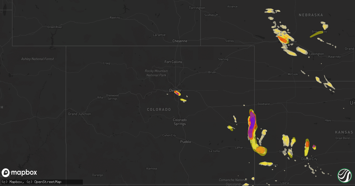
Hail Map on July 15, 2016
Get this storm
July 15 map
$229
one time, instant access
Download today. No call, no setup
Keep the $229
Bought the map and want the full workflow? Apply the entire $229 to a subscription within 7 days. None of it is wasted.
Every map, not just this one
This buys you this map. Subscription and you get every map we run, in the markets you choose from a few cities to whole states to nationwide. Plus real-time alerts the moment a storm fires.
Contact data
Name, contact info, occupancy, even credit band for addresses in the footprint. You go from where it hit to who to call.
Become the source they trust
Unlimited branding weather history reports on demand. You already have the documented answer ready for the property owner, and you are the one who showed up with it.
Property data and RoofTrace estimates
Pull up any address you have got, its value and the exact code rules for that jurisdiction, straight from One Click Code. Then RoofTrace estimates the squares, pitch, and roof value, priced the way you price.
States Impacted by Hail Map on July 15, 2016
Storm reports
Georgia
| Date | Description |
|---|---|
| 07/15/20166:33 PM CDT | The bulloch county warning point reported a tree down near the intersection of jim waters road and aden lanier road. |
| 07/15/20162:57 PM CDT | Tree down resulting in power outage along ousley street nw. Reported on georgia power outage page |
| 07/15/20162:15 PM CDT | Emergency manager reported large tree down on a home off of nelson street. Timing estimated by radar. |
| 07/15/20161:15 PM CDT | Trees and limbs down on power lines near farmers branch rd as well as other scattered areas in decatur and grady counties. |
| 07/14/20167:15 PM CDT | The screven county warning point reported a tree down near oliver landing. |
| 07/14/20167:04 PM CDT | The screven county warning point reported a tree down near the intersection of dorsey clark road and highway 17. |
| 07/14/20167:02 PM CDT | The screven county warning point reported a tree down near the intersection of statesboro highway and highway 17. |
| 07/14/20167:00 PM CDT | The bulloch county warning point reported a tree down on johnson street. |
Ohio
| Date | Description |
|---|---|
| 07/15/20165:49 PM CDT | A local report indicates 60 MPH wind near 2 SSW COOLVILLE |
| 07/15/20165:26 PM CDT | Tree uprooted in yard and dime sized hail during thunderstorm. |
| 07/15/20164:55 PM CDT | Trees down |
| 07/15/20164:52 PM CDT | Trees down in zaleski along us 50. |
| 07/15/20164:43 PM CDT | Trees down along route 328 |
| 07/15/20164:21 PM CDT | Tree down along state rte 124 between rocky fork and marshall. Time estimated by radar. |
| 07/15/20164:19 PM CDT | Tree down on sr 321 between buford and mowrystown. Time estimated by radar. |
| 07/15/20163:50 PM CDT | Trees down on route 564 |
| 07/15/20163:45 PM CDT | Reported at the best western on the southern end of caldwell |
| 07/15/20163:38 PM CDT | Spotter reports quarter to ping pong ball sized hail and cracked windshield just west of the noble-morgan county line on route 78. |
| 07/15/20163:38 PM CDT | Trees down on route 78 just west of the noble-morgan county line. |
South Carolina
| Date | Description |
|---|---|
| 07/15/20166:25 PM CDT | Schp reported a tree down at darby rd and henry rd |
| 07/15/20165:41 PM CDT | Trees down calvin hall rd and harrisburg rd. |
| 07/15/20165:35 PM CDT | Multiple trees down on doby's bridge road. |
| 07/15/20165:25 PM CDT | Trees down along tom hall street with report relayed by columbia weather office. |
| 07/15/20164:55 PM CDT | Several large tree limbs down near highway 321 north of mcconnells. |
| 07/15/20164:21 PM CDT | The dorchester county warning point reported a power line down along mikel road. |
| 07/15/20163:56 PM CDT | The berkeley county warning point reported a tree down along south live oak drive. |
| 07/15/20163:56 PM CDT | The berkeley county warning point reported a tree down along south live oak drive at horseshoe rd. |
| 07/15/20162:30 PM CDT | Power lines down in road |
| 07/15/20162:01 PM CDT | Emergency manager reports 6 trees down on mont clare rd from straight line winds. Time estimated by radar. |
| 07/15/20162:01 PM CDT | Emergency manager reports 3 trees down on flatnose rd. Time estimated by radar. |
| 07/15/20162:01 PM CDT | Report of a tree down on n governor williams hwy. Time estimated by radar. |
| 07/15/20162:00 PM CDT | Tree down on i26 mm154. Eastbound lanes blocked. |
| 07/15/20161:56 PM CDT | Report of a tree down on n center rd. Time estimated by radar. |
| 07/15/20161:40 PM CDT | Report of a tree down on indian branch rd near oates hwy. Time estimated by radar. |
| 07/15/20161:37 PM CDT | Trees down oustley dale rd. |
| 07/15/20161:36 PM CDT | Trees down diane drive. |
| 07/15/20161:34 PM CDT | Trees down middendorf rd. |
| 07/15/20161:32 PM CDT | Tree down on hwy 521 near foreston area. |
| 07/15/20161:30 PM CDT | Electric coop reports outages due to thunderstorm winds hwy 601 between camden and kershaw. |
| 07/15/20161:30 PM CDT | Public report of wind gust 60 mph. Pea size hail also reported. |
| 07/15/20161:30 PM CDT | Electric coop reports outages due to thunderstorm winds hwy 601 between camden and kershaw. |
| 07/15/201612:44 PM CDT | Trees down and dime-size hail near camden. |
| 07/15/201612:41 PM CDT | Black river electric coop reports numerous power outages in the vicinity of kershaw. |
| 07/15/201612:34 PM CDT | Multiple trees down hwy 321... Reservoir rd and hwy 321 bypass. |
| 07/15/201612:16 PM CDT | Tree in roadway 5715 koon rd. |
| 07/15/201612:14 PM CDT | Via social media. Tree down stebondale rd and hwy 321. |
| 07/15/201612:14 PM CDT | Tree on house... Tree on deck and downed power lines. 1 injury reported on delverton road. |
| 07/15/201612:13 PM CDT | Trees down on brock rd. |
| 07/15/201612:13 PM CDT | Trees down on knight road. |
| 07/15/201612:13 PM CDT | Tree down airport rd knight rd. |
| 07/15/201612:11 PM CDT | Tree in roadway sc 277 and fontaine rd. |
| 07/15/201612:11 PM CDT | Tree in roadway sc277 x parklane rd. |
| 07/14/20168:22 PM CDT | Barnwell county dispatch reported trees on hwy 300 near the allendale county line. |
| 07/14/20168:05 PM CDT | Report of tree down on peach rd. |
| 07/14/20167:24 PM CDT | Trees down hwy 215n. |
West Virginia
| Date | Description |
|---|---|
| 07/15/20166:39 PM CDT | Three trees down in point pleasant. |
| 07/15/20166:32 PM CDT | Two large trees over 1 foot in diameter down in corbin branch. |
| 07/15/20166:15 PM CDT | Tree down on pleasant valley road |
| 07/15/20166:15 PM CDT | Single trees down near southpoint and on hite circle |
| 07/15/20166:13 PM CDT | One tree uprooted and tree branches down in boothville |
| 07/15/20166:06 PM CDT | Transformer blowout and lines down. |
Kentucky
| Date | Description |
|---|---|
| 07/15/20164:37 PM CDT | Several trees down in latonia lakes area. Time estimated by radar. |
| 07/15/20164:28 PM CDT | About 10 small trees snapped in half. Street sign blown into field. Part of barn roof peeled away. Time estimated by radar. |
| 07/15/20163:38 PM CDT | Approximately 8 trees down on taylor mill rd. Between cox and klette rds. |
| 07/15/20163:37 PM CDT | Several trees down in latonia lakes area. Time estimated by radar. |
Oklahoma
| Date | Description |
|---|---|
| 07/15/20164:49 PM CDT | Late report...tree branches up to four inch in diameter were snapped. |
| 07/14/201611:30 PM CDT | A local report indicates 63 MPH wind near 3 N ALTUS |
| 07/14/201611:27 PM CDT | A personal weather station |
| 07/14/201611:24 PM CDT | A personal weather station. |
| 07/14/201611:05 PM CDT | A local report indicates 59 MPH wind near 3 N PUTNAM |
| 07/14/201611:00 PM CDT | A local report indicates 63 MPH wind near 3 W GOULD |
| 07/14/201610:55 PM CDT | A local report indicates 64 MPH wind near 3 W GOULD |
| 07/14/201610:45 PM CDT | A local report indicates 58 MPH wind near 4 WNW BESSIE |
| 07/14/20169:55 PM CDT | A local report indicates 62 MPH wind near 4 WNW CAMARGO |
| 07/14/20169:50 PM CDT | A local report indicates 60 MPH wind near 4 WNW CAMARGO |
| 07/14/20169:45 PM CDT | A local report indicates 65 MPH wind near 4 WNW CAMARGO |
| 07/14/20169:40 PM CDT | A local report indicates 58 MPH wind near 4 WNW CAMARGO |
| 07/14/20169:30 PM CDT | A local report indicates 60 MPH wind near 1 SE REYDON |
| 07/14/20169:20 PM CDT | A local report indicates 58 MPH wind near 2 WSW WOODWARD |
| 07/14/20169:15 PM CDT | A local report indicates 59 MPH wind near 2 WSW WOODWARD |
| 07/14/20168:31 PM CDT | A local report indicates 59 MPH wind near 2 SW GAGE |
| 07/14/20168:00 PM CDT | A local report indicates 65 MPH wind near 6 WNW LAVERNE |
| 07/14/20167:53 PM CDT | A local report indicates 65 MPH wind near 8 W SLAPOUT |
| 07/14/20167:50 PM CDT | A local report indicates 60 MPH wind near 8 W SLAPOUT |
| 07/14/20167:26 PM CDT | Semi truck blown over on highway 412 west of route 23. |
| 07/14/20167:26 PM CDT | Semi truck blown over on highway 412 east of highway 83 |
| 07/14/20167:20 PM CDT | A local report indicates 75 MPH wind near BEAVER |
| 07/14/20167:20 PM CDT | A local report indicates 61 MPH wind near 1 SSW BEAVER |
Colorado
| Date | Description |
|---|---|
| 07/15/20166:32 PM CDT | A local report indicates 1.25 inch wind near 2 NE DENVER |
| 07/15/20166:32 PM CDT | A local report indicates 1.75 inch wind near NE GREENWOOD VILLAGE |
| 07/15/20166:31 PM CDT | Half dollar to ping pong ball sized hail near washington park. |
| 07/15/20166:29 PM CDT | A local report indicates 1.50 inch wind near 2 NW DENVER |
| 07/15/20166:25 PM CDT | A local report indicates 1.00 inch wind near 3 N GREENWOOD VILLAGE |
| 07/15/20166:25 PM CDT | A local report indicates 2.00 inch wind near 3 NW CENTENNIAL |
| 07/15/20166:24 PM CDT | A local report indicates 1.00 inch wind near 2 NNE GREENWOOD VILLAGE |
| 07/15/20166:18 PM CDT | A local report indicates 1.75 inch wind near SE DENVER |
| 07/15/20165:04 PM CDT | Mesonet station klaa - lamar airport. . |
| 07/15/20165:04 PM CDT | Asos station lamar airport /laa/. |
| 07/15/20164:01 PM CDT | Damaged car windows |
| 07/15/20164:01 PM CDT | Broke tree branches and striped tree bark |
| 07/15/20163:59 PM CDT | . |
| 07/15/20163:55 PM CDT | Windows blown out on house. Truck was moved into a ditch. |
| 07/15/20163:19 PM CDT | A local report indicates a tornado near 7 SE CHEYENNE WELLS |
| 07/15/20163:19 PM CDT | A local report indicates 2.50 inch wind near ARAPAHOE |
| 07/15/20163:08 PM CDT | A local report indicates a tornado near 5 S ARAPAHOE |
| 07/14/20167:14 PM CDT | A local report indicates 1.00 inch wind near 1 ESE THE PINERY |
| 07/14/20167:04 PM CDT | A local report indicates 1.00 inch wind near 1 ESE THE PINERY |
Illinois
| Date | Description |
|---|---|
| 07/15/20165:20 PM CDT | Kfvs-12 viewer reports a few trees down as they drove through town. |
| 07/15/20164:15 PM CDT | Some trees and power lines down in junction and shawneetown. |
Pennsylvania
| Date | Description |
|---|---|
| 07/15/20162:50 PM CDT | Tree down at intersection of thompsonville and mcmurry roads. Time estimated from radar. |
South Dakota
| Date | Description |
|---|---|
| 07/15/20166:20 PM CDT | A local report indicates 1.00 inch wind near 6 SSW DOWNTOWN RAPID CI |
| 07/15/20166:12 PM CDT | A local report indicates 1.00 inch wind near 4 NE ROCKERVILLE |
| 07/15/20164:30 PM CDT | A local report indicates 1.00 inch wind near 1 N HISEGA |
Massachusetts
| Date | Description |
|---|---|
| 07/15/20162:35 PM CDT | A local report indicates 63 MPH wind near 3 NW PROVINCETOWN |
Kansas
| Date | Description |
|---|---|
| 07/15/20166:50 PM CDT | There was considerable tree damage. The time was estimated from radar. |
| 07/15/20166:45 PM CDT | Reports of several trucks rolled over on highway 54... Power poles blown down... And campers overturned. A hanger was damaged at the airport with a plane found upside d |
| 07/15/20166:39 PM CDT | Several 12 to 14 inch diameter tree limbs blown down. Time was estimated by radar. |
| 07/15/20166:35 PM CDT | Report was from the meade airport. |
| 07/15/20166:25 PM CDT | Reports of several 6 to 7 inch diameter tree limbs down in montezuma. |
| 07/15/20166:20 PM CDT | Law enforcement reported a semi was blown over on highway 50. |
| 07/15/20166:15 PM CDT | Lost window too |
| 07/15/20165:42 PM CDT | . |
| 07/15/20165:34 PM CDT | A local report indicates 1.25 inch wind near 7 E COOLIDGE |
| 07/15/20165:27 PM CDT | This report is at the garden city airport. |
| 07/15/20165:21 PM CDT | A local report indicates 1.25 inch wind near 9 W JETMORE |
| 07/15/20165:07 PM CDT | A local report indicates a tornado near 5 E COOLIDGE |
| 07/15/20165:07 PM CDT | Chaser reported cone tornado that lasted 20 mins. |
| 07/15/20165:07 PM CDT | The tornado was report near county road l and highway 50. |
| 07/15/20165:02 PM CDT | Some stones larger |
| 07/15/20164:56 PM CDT | . |
| 07/15/20164:25 PM CDT | Tree branches up to 2 and 1/2 inches in diameter broke off of trees |
Nebraska
| Date | Description |
|---|---|
| 07/15/20168:50 AM CDT | A local report indicates 1.75 inch wind near 8 WNW NORTH PLATTE |
| 07/15/20168:42 AM CDT | Ground is covered |
| 07/15/20168:20 AM CDT | Ground covered with pea sized but largest were quarters |
Louisiana
| Date | Description |
|---|---|
| 07/15/20165:05 PM CDT | Power line down in town |
| 07/15/20165:00 PM CDT | A few trees were down in the leland area. |
| 07/15/201612:15 PM CDT | Trees down at intersection of hwy 190 and indian hills road. |
| 07/14/20168:36 PM CDT | Trees snapped or uprooted and power lines down at boswick road at pleasant grove drive |
| 07/14/20168:34 PM CDT | Nws employee est 60 mph gust at deep wood subdv. Power out |
| 07/14/20168:25 PM CDT | 2 trees donw in frierson... Whites spring road and stonewall-frierson road |
| 07/14/20168:25 PM CDT | Widespread tree and power line damage reported parish wide... Shreveport... Keithville... Blanchard... Mooringsport |
| 07/14/20167:01 PM CDT | Tree down on highway 157 north of bossier |
Missouri
| Date | Description |
|---|---|
| 07/15/20164:15 PM CDT | A local report indicates 1.00 inch wind near 3 SW LEOPOLD |
| 07/15/20162:20 PM CDT | Large tree limbs down. Torrential rain with minor flooding. Winds estimated 60 mph with this storm. |
| 07/15/20163:40 AM CDT | Trees and powerlines down near the end of route y southeast of lupus and northeast of jamesdown. |
Florida
| Date | Description |
|---|---|
| 07/15/20163:45 PM CDT | Tree down near old dixie hwy and dyal road |
| 07/15/20163:11 PM CDT | Spotter reported tree and powerlines downed off of nw 107th trail. Timing estimated by radar. |
| 07/15/20163:10 PM CDT | Emergency manager reported a tree downed causing a power outage off of fort clark blvd. |
| 07/15/20162:50 PM CDT | Public reported tree down on a home at the intersection of hwy 301 and cr 227. |
| 07/15/20162:45 PM CDT | Tree and powerlines down at 3960 jammes road time estimated based on radar |
| 07/15/20162:45 PM CDT | Tree leaning on top of power lines along springhill road just north of highway 267. Tree appeared to be uprooted. |
| 07/15/20162:12 PM CDT | Public report via social media of a tree downed. Timing estimated by radar. |
Indiana
| Date | Description |
|---|---|
| 07/15/20163:00 PM CDT | Quarter inch hail reported. |
New York
| Date | Description |
|---|---|
| 07/15/20165:35 PM CDT | Up to quarter sized hail on lawson lake road |
| 07/15/20165:30 PM CDT | Up to quarter sized hail on lawson lake road |
| 07/15/20164:36 PM CDT | Tree and wires down across route 67 |
| 07/15/20164:30 PM CDT | Medium sized branches down in shuttleworth park...time estimated |
| 07/15/20164:20 PM CDT | Few trees down in town...time estimated |
| 07/15/20164:03 PM CDT | 2 trees down |
| 07/15/20164:00 PM CDT | Few trees downin caroga lake...time estimated |
| 07/15/20163:20 PM CDT | 2 trees down rt. 169 near davis road intersection...time estimated |
| 07/15/20163:20 PM CDT | Trees down in village of herkimer...time estimated |
| 07/15/20163:15 PM CDT | Tree down rasbach rd. Near intersection with west end road...time estiimated |
| 07/15/20163:14 PM CDT | 2 trees down rt. 169 near davis road intersection...time estimated |
| 07/15/20163:12 PM CDT | Tree down rasbach rd. Near intersection with west end road...time estiimated |
| 07/15/20163:10 PM CDT | Estimated 100 trees downed near upper great brook rd. |
Arkansas
| Date | Description |
|---|---|
| 07/15/20166:50 PM CDT | A few trees down on powerlines. |
| 07/15/20165:31 PM CDT | A few tree limbs greater than 6 inches down on highway 18 in roseland. |
New Mexico
| Date | Description |
|---|---|
| 07/15/20162:44 PM CDT | Metar report of 50kt wind gust at santa fe.... Ksaf asos. |
| 07/14/20167:56 PM CDT | A local report indicates 1.25 inch wind near 2 E CLOVIS |
Texas
| Date | Description |
|---|---|
| 07/15/20165:45 PM CDT | Tree on home fair street. Also w.pincrest closed due to downed trees and lines across road. |
| 07/15/20165:40 PM CDT | Several trees reported down in jefferson on wilson and mlk roads. |
| 07/15/20165:20 PM CDT | Public post photo of quarter size hail in hallsville on kltv facebook page. |
| 07/15/20165:02 PM CDT | Hail between longview and judson... High wind ripped lattice off |
| 07/15/20164:38 PM CDT | Tree down astor raod and fm 2796 |
| 07/15/20164:36 PM CDT | Tree down 726 north of 259 just south of ore city |
| 07/15/20164:20 PM CDT | Shop house was destroyed on gardenia road |
| 07/15/20163:54 PM CDT | Numerous trees and power lines down across city |
| 07/15/20163:42 PM CDT | Numerous trees and powerlines down across western part of county |
| 07/15/20163:10 PM CDT | Tree down on hwy 11 west |
| 07/15/201610:57 AM CDT | Childress asos |
| 07/15/20169:22 AM CDT | Delayed report---trees down at the intersections of legacy and chase oaks---parks boulevard and mira vista---custer and spring creek---midway and parker. |
| 07/15/20168:45 AM CDT | Over 60 mph winds reported se of ponder and sw of denton. Patio furniture being blown down in the robson ranch area. |
| 07/15/20168:10 AM CDT | Estimated 60 mph winds and some urban flooding on mulberry street in decatur. |
| 07/15/20167:15 AM CDT | Tree down in sunset on picket run road near highway 101 |
| 07/14/201611:05 PM CDT | West texas mesonet report |
| 07/14/201610:57 PM CDT | Childress asos |
| 07/14/201610:50 PM CDT | Childress asos |
| 07/14/201610:10 PM CDT | Roof removed from barn |
| 07/14/20169:59 PM CDT | Late report received. |
| 07/14/20169:45 PM CDT | West texas mesonet report |
| 07/14/20169:29 PM CDT | Late report...68 mph thunderstorm wind gust received from broadcast media |
| 07/14/20168:54 PM CDT | Late report...visibility reduced to less than a mile in sideways blowing rain. Time estimated from doppler radar. |
| 07/14/20168:45 PM CDT | 4 inch diameter tree limb was downed. |
| 07/14/20168:39 PM CDT | A local report indicates 66 MPH wind near 8 E LORA |
| 07/14/20168:34 PM CDT | A local report indicates 64 MPH wind near 2 NE LAKE TANGLEWOOD |
| 07/14/20168:07 PM CDT | A local report indicates 62 MPH wind near 1 S BORGER |
| 07/14/20167:24 PM CDT | A local report indicates 59 MPH wind near 7 ENE VALLEY DE ORO |
| 07/14/20167:15 PM CDT | A local report indicates 70 MPH wind near 3 ENE PERRYTON |
| 07/14/20167:07 PM CDT | A local report indicates 61 MPH wind near 11 WNW BOOTLEG |
| 07/14/20167:00 PM CDT | A local report indicates 60 MPH wind near 11 WNW BOOTLEG |
Rhode Island
| Date | Description |
|---|---|
| 07/15/20162:00 PM CDT | Multiple trees and large branches down with power outages on hope street near gooding avenue |
| 07/15/20161:54 PM CDT | Overturned sailboat near oakland beach near warwick neck...seven people rescued uninjured |
| 07/15/20161:35 PM CDT | Trees and wires down on camp avenue near quonset airport |
| 07/15/20161:30 PM CDT | Trees and wires down |
Montana
| Date | Description |
|---|---|
| 07/15/201612:40 AM CDT | Cow creek raws |
| 07/14/201611:55 PM CDT | Badger peak raws |
| 07/14/20169:42 PM CDT | A local report indicates 60 MPH wind near 5 S BILLINGS |
| 07/14/20169:18 PM CDT | A local report indicates 60 MPH wind near 6 SSW MOLT |
| 07/14/20168:30 PM CDT | A local report indicates 1.00 inch wind near 10 W ABSAROKEE |
| 07/14/20167:44 PM CDT | A local report indicates 61 MPH wind near 3 WSW NYE |
| 07/14/20167:20 PM CDT | Hail estimated to be quarter size fell near sweet grass. |
Tennessee
| Date | Description |
|---|---|
| 07/15/20166:45 PM CDT | Tin roof ripped off house on old memphis road near billings drive. Several large trees down in the area. |
| 07/15/20166:27 PM CDT | Quarter size hail near rosemark |
| 07/15/20165:06 PM CDT | Multiple trees down near intersection of winchester and perkins. Time is radar estimated. |
| 07/15/20165:06 PM CDT | Multiple trees down near intersection of winchester and perkins. Time is radar estimated. |
| 07/15/20165:03 PM CDT | An awning was blown off a building on lamar avenue. |
North Carolina
| Date | Description |
|---|---|
| 07/15/20165:45 PM CDT | Multiple trees and power lines down across burlington. |
| 07/15/20165:42 PM CDT | 2 trees down near highway 481 and sorietown road. |
| 07/15/20165:13 PM CDT | Numerous trees down across western nash county. |
| 07/15/20164:54 PM CDT | Trees and lines down throughout city. |
| 07/15/20164:12 PM CDT | Trees and lines down throughout the city. |
| 07/15/20164:12 PM CDT | Trees and lines down throughout city. |
| 07/15/20164:00 PM CDT | Trees down on hope valley road. |
| 07/15/20163:50 PM CDT | Large tree branches down across us 264 east of belhaven |
| 07/15/20163:50 PM CDT | *** 1 inj *** trees fell on a truck... One person injured and transported to the hospital; this a corrected location to a previous report. |
| 07/15/20163:45 PM CDT | Report of several structures damaged |
| 07/15/20163:07 PM CDT | Tree down at the 6400 block of highway 82. |
| 07/15/20163:05 PM CDT | Tree down at the 300 block of benson highway. |
| 07/15/20163:05 PM CDT | *** 1 inj *** trees fell on a truck... One person injured and went to the hospital. |
| 07/15/20163:04 PM CDT | Emergency manager reports that a tin outbuilding on horseshoe road rolled over and parts of the tin found 100 yards downstream in a power line. Several large oak... Pin |
| 07/15/20163:04 PM CDT | Emergency manager reports over 20 large trees down in the 1500 block of collins road. Most of the downed trees were large oaks... Pine... And poplar trees. |
| 07/15/20163:04 PM CDT | Over 30 large trees down in the 1300 block of francis road along with several power lines. A number of shingles ripped off the ridge line of the roof of a home at this |
| 07/15/20163:00 PM CDT | 12+ trees down in the area of westfield and albion rds. Time radar estimated. |
| 07/15/20163:00 PM CDT | Multiple trees down in the area of asbury and locust rds. Time radar estimated. |
| 07/15/20162:45 PM CDT | Nickel to quarter size hail. Time estimated by radar. . |
| 07/15/20162:40 PM CDT | Trees down in riverbend. Large tree down on shoreline drive. Time estimated. |
| 07/15/20162:38 PM CDT | 53 knot wind gust observed at pope army field. . |
| 07/15/20162:00 PM CDT | Two trees down... One of which knocked power line onto nc690... Closing the road. Many limbs down on woodlake country club grounds. |
| 07/15/201612:40 PM CDT | Multiple trees and power lines down across the city. . |
Virginia
| Date | Description |
|---|---|
| 07/15/20165:18 PM CDT | 51 knot gust at chesapeake bay bridge tunnel 1st island. |
Cities Impacted by Hail Map on July 15, 2016
- Taloga, OK
- Arnett, OK
- Butler, OK
- Leedey, OK
- Camargo, OK
- Vici, OK
- Sunray, TX
- Stratford, TX
- Manila, AR
- Erwin, NC
- Mclean, TX
- Hawesville, KY
- Pomaria, SC
- Chesapeake, VA
- Moyock, NC
- Cordesville, SC
- Bonneau, SC
- Moncks Corner, SC
- Clovis, NM
- Cambridge, NE
- Bartley, NE
- Elizabethtown, NC
- Syracuse, KS
- Denver, CO
- Englewood, CO
- Littleton, CO
- Aurora, CO
- Haskell, TX
- Coward, SC
- Olanta, SC
- Scranton, SC
- Jamestown, MO
- Tampa, FL
- Junction, IL
- Equality, IL
- Wilsall, MT
- Sheridan Lake, CO
- Arapahoe, CO
- Shamrock, TX
- Tavares, FL
- Mount Dora, FL
- Rule, TX
- Rogers, NM
- Longview, TX
- Central City, KY
- Henning, TN
- Osceola, AR
- Wilson, AR
- Conway, SC
- Myrtle Beach, SC
- Hartsville, SC
- Patrick, SC
- Electra, TX
- Harrold, TX
- San Jon, NM
- Turkey, NC
- Warsaw, NC
- Magnolia, NC
- Cut Bank, MT
- Enfield, NC
- Decatur, TX
- Georgetown, SC
- Curtis, NE
- Wellfleet, NE
- Maywood, NE
- Hammon, OK
- Whitewater, MO
- Chaffee, MO
- Astatula, FL
- Groveland, FL
- Clermont, FL
- Howey In The Hills, FL
- Weskan, KS
- Tribune, KS
- Tryon, NE
- Hershey, NE
- Stapleton, NE
- North Platte, NE
- Sutherland, NE
- Paxton, NE
- Jacksboro, TX
- Bowie, TX
- Sunset, TX
- Chico, TX
- Doniphan, MO
- Cheraw, SC
- Lilesville, NC
- Wallace, SC
- Morven, NC
- Wadesboro, NC
- Chesterfield, SC
- Alamogordo, NM
- Weinert, TX
- Spring Hope, NC
- Zebulon, NC
- Middlesex, NC
- Bunn, NC
- Louisburg, NC
- Cumberland, OH
- Blue Rock, OH
- Caldwell, OH
- Mcconnelsville, OH
- Redfield, AR
- Black, MO
- Clarendon, NC
- Nakina, NC
- Tabor City, NC
- Guysville, OH
- Athens, OH
- Cutler, OH
- Elon, NC
- Whitsett, NC
- Liberty, NC
- Burlington, NC
- Julian, NC
- Millington, TN
- Arlington, TN
- Atoka, TN
- Brighton, TN
- Cozad, NE
- Gothenburg, NE
- Brady, NE
- Tipton, OK
- Stamford, TX
- Throckmorton, TX
- Skellytown, TX
- Canyon, TX
- Columbia, LA
- Senatobia, MS
- Coldwater, MS
- Zuni, VA
- Malden, MO
- Campbell, MO
- Circleville, OH
- Aspermont, TX
- Old Glory, TX
- Whitakers, NC
- Statesboro, GA
- Moccasin, MT
- Kramer, ND
- Bottineau, ND
- Souris, ND
- Hamlet, NC
- Puxico, MO
- Scott City, KS
- Garden City, KS
- Coolville, OH
- Great Falls, MT
- Cascade, MT
- Elizabeth, CO
- Franktown, CO
- Parker, CO
- Panhandle, TX
- Groom, TX
- White Deer, TX
- Benton, AR
- Memphis, TN
- Whitman, NE
- Hermosa, SD
- Rapid City, SD
- Caputa, SD
- Hill City, SD
- Reed Point, MT
- Columbus, MT
- Big Timber, MT
- Elberon, VA
- Surry, VA
- Wakefield, VA
- Smithfield, VA
- Ivor, VA
- Elk City, OK
- Farwell, TX
- Oconto, NE
- Amarillo, TX
- Centerville, MO
- Dumas, TX
- Jonesville, LA
- Harrisonburg, LA
- Dunn, NC
- Linden, NC
- Pageland, SC
- Mount Croghan, SC
- Jefferson, SC
- Gilmer, TX
- Pampa, TX
- Hollis, OK
- Gould, OK
- Willow, OK
- Erick, OK
- Wellington, TX
- Dodson, TX
- Mangum, OK
- Vinson, OK
- Cairo, IL
- Burlington, CO
- Augusta, MT
- Paducah, TX
- Hilliard, FL
- Callahan, FL
- Wolf Creek, MT
- Childress, TX
- Denton, TX
- Marble Hill, MO
- Portales, NM
- Las Vegas, NM
- Montezuma, NM
- Shawmut, MT
- Campo, CO
- Hardinsburg, KY
- Live Oak, FL
- Coushatta, LA
- Darlington, SC
- Monterey, LA
- Acme, LA
- Canaan, IN
- Butlerville, IN
- Madison, IN
- Dupont, IN
- Quanah, TX
- Carmi, IL
- New Haven, IL
- Camden, SC
- Cassatt, SC
- Bishopville, SC
- Paron, AR
- Fayetteville, NC
- Sarah, MS
- Crenshaw, MS
- Jetmore, KS
- Dodge City, KS
- Hampton, FL
- Starke, FL
- Pink Hill, NC
- Beulaville, NC
- Ashland, KS
- Clarendon, TX
- Claude, TX
- Mullen, NE
- Grayson, LA
- Sikes, LA
- Effingham, SC
- Timmonsville, SC
- Lesterville, MO
- Walsh, CO
- Birdseye, IN
- Bristow, IN
- Hobart, OK
- Healy, KS
- Sweet Grass, MT
- Sunburst, MT
- Spearman, TX
- Sharon, SC
- McConnells, SC
- McArthur, OH
- Creola, OH
- New Plymouth, OH
- Zaleski, OH
- Ozark, AL
- Ariton, AL
- Warsaw, KY
- Florence, IN
- Patriot, IN
- Muleshoe, TX
- Lakeview, TX
- Cordell, OK
- Kenansville, NC
- Holly, CO
- Fort Mill, SC
- Rock Hill, SC
- Happy, TX
- Minneola, KS
- Holcomb, KS
- Manhattan, MT
- Chatham, LA
- Ridgway, IL
- Quitaque, TX
- Kit Carson, CO
- Fishtail, MT
- Nye, MT
- McLeod, MT
- Absarokee, MT
- Clinton, NC
- Fort Supply, OK
- Kendall, KS
- Cheyenne Wells, CO
- Coolidge, KS
- Natchitoches, LA
- Society Hill, SC
- Denton, MT
- Sulphur, LA
- Vinton, LA
- Blair, SC
- Jenkinsville, SC
- Midlothian, TX
- Granite, OK
- Hallsville, TX
- Bell City, MO
- Pembroke, GA
- Olla, LA
- Trout, LA
- New Bern, NC
- Bucklin, KS
- Wichita Falls, TX
- Zalma, MO
- Diana, TX
- Lockney, TX
- Silverton, TX
- Flomot, TX
- Hensley, AR
- Sheridan, AR
- Westbrook, TX
- Colorado City, TX
- Briscoe, TX
- Canadian, TX
- Chandler, IN
- Elberfeld, IN
- Cadiz, KY
- Rich Square, NC
- Bladenboro, NC
- Turkey, TX
- Marshall, TX
- Blackstone, VA
- Memphis, TX
- Hereford, TX
- Broadview, NM
- McKenney, VA
- Saint Meinrad, IN
- Ferdinand, IN
- Wake Forest, NC
- Rolesville, NC
- Dickens, NE
- Duke, OK
- Jacksonville, FL
- Stover, MO
- Farnam, NE
- Camden, TN
- North, SC
- Halifax, NC
- Altus, OK
- Kyle, SD
- Frederick, OK
- Lamar, IN
- Santa Claus, IN
- Huntingburg, IN
- Dale, IN
- English, IN
- Saint Croix, IN
- Dubois, IN
- Jasper, IN
- Evanston, IN
- Taswell, IN
- Eckerty, IN
- Celestine, IN
- Loomis, NE
- Beaver City, NE
- Stamford, NE
- Ore City, TX
- Leopold, MO
- Sargent, NE
- Broken Bow, NE
- Ponder, TX
- Justin, TX
- Krum, TX
- Hawthorne, FL
- Almena, KS
- Long Island, KS
- Winnsboro, SC
- Fremont, MO
- Arthur, NE
- Stoutsville, OH
- Tarlton, OH
- Laurelville, OH
- Amanda, OH
- Pierceville, KS
- Phillipsburg, KS
- Trenton, FL
- Johnson, KS
- Mountain View, OK
- Carnegie, OK
- Gotebo, OK
- Currituck, NC
- Shawboro, NC
- Roseboro, NC
- Warsaw, MO
- Whigham, GA
- Water Valley, MS
- Coffeeville, MS
- Punta Gorda, FL
- Lancaster, OH
- Evansville, IN
- Center Point, LA
- Deville, LA
- Vidalia, LA
- Evergreen, NC
- Agra, KS
- Ahoskie, NC
- Bethune, CO
- Turbeville, SC
- Lugoff, SC
- Kingsland, GA
- Harleton, TX
- Browning, MT
- Mescalero, NM
- Pleasanton, NE
- Virginia Beach, VA
- Rocky, OK
- Blair, OK
- Orleans, NE
- Manning, SC
- Godwin, NC
- Wade, NC
- Corapeake, NC
- Sunbury, NC
- Lawrenceburg, KY
- McKenzie, TN
- Henry, TN
- Carter, MT
- Mount Vernon, IN
- Madison, FL
- Chillicothe, TX
- Vernon, TX
- Eldorado, OK
- Bridgeport, TX
- Alvord, TX
- Newberry, FL
- Winnsboro, TX
- Pine Ridge, SD
- Smithland, KY
- Ledbetter, KY
- Brookport, IL
- Alma, NE
- Kensington, KS
- Maxwell, NE
- Williamsburg, OH
- Cactus, TX
- Arcadia, LA
- De Witt, AR
- Paradise, TX
- Kelly, LA
- Port Charlotte, FL
- North Port, FL
- Aurora, NC
- Ansley, NE
- Westerville, NE
- Comstock, NE
- Durham, NC
- Glencoe, KY
- Sharon, OK
- Fargo, OK
- Miami, TX
- Gold Creek, MT
- Morgantown, KY
- Leachville, AR
- Arbyrd, MO
- Hornersville, MO
- Cheyenne, OK
- Rociada, NM
- Rolla, KS
- Clifton, TN
- Ulysses, KS
- Lake City, SC
- Brownsville, TN
- Morton, TX
- Buchanan, TN
- Springville, TN
- Alton, MO
- Greenville, MO
- Rose Hill, NC
- Brooksville, FL
- Bard, NM
- Gatewood, MO
- Morriston, FL
- Dunnellon, FL
- McBee, SC
- Lelia Lake, TX
- Hedley, TX
- Whiteville, NC
- Vass, NC
- Sentinel, OK
- Lone Wolf, OK
- Ridgeville, SC
- Jonesboro, IL
- High Springs, FL
- Perryton, TX
- Mutual, OK
- Youngsville, NC
- Wendell, NC
- White Oak, NC
- New Concord, KY
- Latonia, KY
- Independence, KY
- Pittsburg, TX
- Quail, TX
- New Harmony, IN
- Waynesboro, TN
- Garland, NC
- Pinopolis, SC
- Clinton, OK
- Hanover, IN
- Nabb, IN
- Grantsburg, IL
- Effie, LA
- Marksville, LA
- McAlpin, FL
- O'Brien, FL
- Port Allen, LA
- Belknap, IL
- Vienna, IL
- Galivants Ferry, SC
- Hornsby, TN
- Adams Run, SC
- Lewistown, MT
- Bernice, LA
- Marysville, IN
- Lexington, IN
- Versailles, MO
- Barnett, MO
- Beaver, OK
- Chapel Hill, NC
- Cedar Hill, TX
- Gruver, TX
- Kelford, NC
- Aulander, NC
- Roxobel, NC
- Anselmo, NE
- Eddyville, IL
- Norris City, IL
- Morse, TX
- Traskwood, AR
- Arapaho, OK
- Trenton, NC
- Paragould, AR
- Rockingham, NC
- Loris, SC
- Brunswick, GA
- Teachey, NC
- Hanston, KS
- Molt, MT
- Moorefield, NE
- Advance, MO
- Bloomfield, MO
- Hermleigh, TX
- Bath Springs, TN
- Grand Rivers, KY
- Gleason, TN
- Eustis, NE
- Amesville, OH
- Winston, MT
- Gresham, SC
- Davidson, OK
- Cove City, NC
- Dover, NC
- Waverly, GA
- Stanford, MT
- Fowler, KS
- Green Cove Springs, FL
- Bells, TN
- Olar, SC
- Dill City, OK
- Canute, OK
- Crowell, TX
- Pilot Point, TX
- Newton Grove, NC
- Goodwell, OK
- Keyes, OK
- Lane, SC
- Andrews, SC
- Thonotosassa, FL
- Seffner, FL
- Suffolk, VA
- Gates, NC
- Four Oaks, NC
- Boise City, OK
- Downsville, LA
- Calhoun, LA
- Ingalls, KS
- Lake Park, GA
- Mantee, MS
- Toone, TN
- Medicine Lodge, KS
- Ville Platte, LA
- Winnsboro, LA
- Fort Necessity, LA
- Shattuck, OK
- Walker, WV
- Parkersburg, WV
- West Paducah, KY
- Paducah, KY
- Shade, OH
- Deadwood, SD
- Rising Sun, IN
- Vevay, IN
- Metropolis, IL
- Elizabeth City, NC
- South Mills, NC
- Dundee, MS
- Corning, AR
- Simsboro, LA
- Cape Coral, FL
- Morganfield, KY
- Tinnie, NM
- Roosevelt, OK
- Choteau, MT
- Ashland, MT
- Lame Deer, MT
- Pocahontas, TN
- Lamar, SC
- Jena, LA
- Pecos, NM
- Green Sea, SC
- Greenville, NC
- Ayden, NC
- Gideon, MO
- Washington, WV
- Belleville, WV
- Reedsville, OH
- Albany, OH
- Custer City, OK
- Como, TX
- Quitman, TX
- Pickton, TX
- Van Buren, MO
- Hugoton, KS
- Coldwater, KS
- New Marshfield, OH
- Hamden, OH
- South Bloomingville, OH
- Newport News, VA
- Fort Eustis, VA
- Waverly, OH
- Bainbridge, OH
- Iowa Park, TX
- Lake Charles, LA
- Manderson, SD
- Branford, FL
- Bell, FL
- Peachland, NC
- Dell, AR
- Senath, MO
- York, SC
- Melrose, FL
- Earleton, FL
- Coppell, TX
- Mason City, NE
- Prudence Island, RI
- North Kingstown, RI
- Bristol, RI
- Portsmouth, RI
- Holly Hill, SC
- Munford, TN
- Burlison, TN
- Drummonds, TN
- Seymour, TX
- Sayre, OK
- Buchtel, OH
- Millfield, OH
- Glouster, OH
- Nelsonville, OH
- Valier, MT
- Sanger, TX
- Aubrey, TX
- Cofield, NC
- Marston, NC
- Waynesville, GA
- Nahunta, GA
- Hortense, GA
- Indian Hills, CO
- Evergreen, CO
- Carter, OK
- Wilsons, VA
- Chrisney, IN
- Grandview, IN
- Ruston, LA
- Guymon, OK
- Kirwin, KS
- Marshville, NC
- Friona, TX
- Dupuyer, MT
- Lewisville, TX
- Argyle, TX
- Red Oak, TX
- Waxahachie, TX
- Nashville, NC
- Fort Worth, TX
- Roanoke, TX
- Yorktown, VA
- Seaford, VA
- Fort Cobb, OK
- Fort Bragg, NC
- Hall, MT
- Waldo, FL
- Edwards, MO
- Castalia, NC
- Raleigh, NC
- Bunker, MO
- Elizabethtown, IL
- Shawneetown, IL
- Bronson, FL
- Archer, FL
- Pittsboro, NC
- Wadesville, IN
- Gipsy, MO
- McGee, MO
- Miller City, IL
- Tell, TX
- Scottsburg, IN
- Underwood, IN
- Baton Rouge, LA
- Ryegate, MT
- Summerville, SC
- Ruby, SC
- Eustis, FL
- Wisner, LA
- Boonville, IN
- Spring Grove, VA
- Hendley, NE
- Wilsonville, NE
- Cameron, NC
- Olustee, OK
- Lehigh Acres, FL
- Fort Myers, FL
- Manter, KS
- Protection, KS
- Rolla, MO
- Salem, MO
- Eads, CO
- Dighton, KS
- Ness City, KS
- Galata, MT
- Selkirk, NY
- Feura Bush, NY
- Callaway, NE