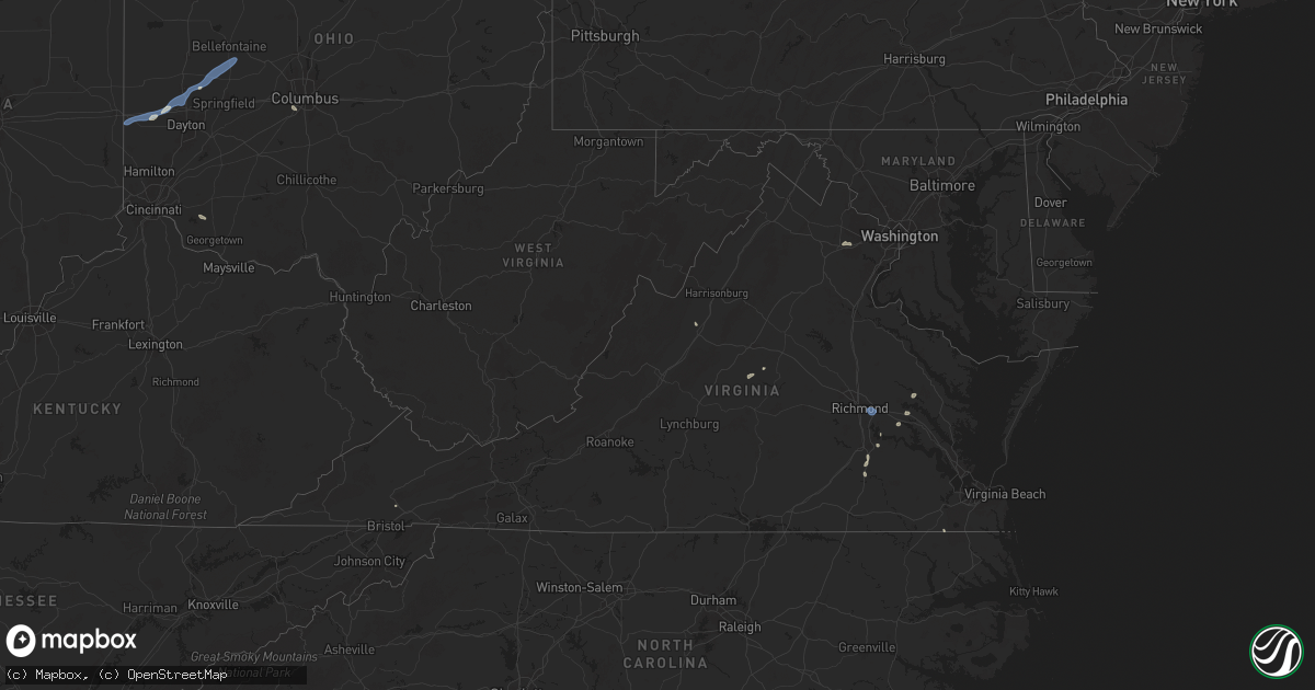
Hail Map in Virginia on July 12, 2025
Get this storm
July 12 map
$229
one time, instant access
Download today. No call, no setup
Keep the $229
Bought the map and want the full workflow? Apply the entire $229 to a subscription within 7 days. None of it is wasted.
Every map, not just this one
This buys you this map. Subscription and you get every map we run, in the markets you choose from a few cities to whole states to nationwide. Plus real-time alerts the moment a storm fires.
Contact data
Name, contact info, occupancy, even credit band for addresses in the footprint. You go from where it hit to who to call.
Become the source they trust
Unlimited branding weather history reports on demand. You already have the documented answer ready for the property owner, and you are the one who showed up with it.
Property data and RoofTrace estimates
Pull up any address you have got, its value and the exact code rules for that jurisdiction, straight from One Click Code. Then RoofTrace estimates the squares, pitch, and roof value, priced the way you price.
Storm reports in Virginia
Virginia
| Date | Description |
|---|---|
| 07/12/20255:03 PM CDT | Large tree down at 11409 drop forge ln |
| 07/12/20254:01 PM CDT | Tree down in the roadway at kettle pond lane near route 7. |
| 07/12/20253:27 PM CDT | Two trees reported down near thornhill. |
| 07/12/20253:27 PM CDT | Two trees reported down near thornhil |
| 07/12/20253:18 PM CDT | Two trees down just west of lahore on lahore road. |
| 07/12/20252:43 PM CDT | The 911 call center reported a tree down along i-95 northbound near mile marker 35. Vdot reported the tree down at mile marker 35.2. Time estimated from radar. |
| 07/12/20252:16 PM CDT | The 911 call center reported a tree down along the intersection of va 33 and va 249. Time estimated from radar. |
| 07/12/20252:11 PM CDT | The 911 call center reported a tree down along the intersection of cooks mill road and highway 249. |
| 07/12/20251:28 PM CDT | 4 different reports of downed trees across scottsville. |
| 07/12/20251:04 PM CDT | Tree reported down on old buckingham rd blocking all lanes. |
| 07/12/202512:48 PM CDT | A 64 mph wind gust was measured by the richmond international airport asos. |
| 07/12/202512:35 PM CDT | 5 trees down in the 4000 block of monocan trail road |
| 07/12/202512:20 PM CDT | A large tree fell across peach court near bassett... Va... Blocking the road. |
| 07/12/202512:13 PM CDT | Tree down on power lines along cedar street. |
All States Impacted by Hail Map on July 12, 2025
Cities Impacted by Hail Map on July 12, 2025
- Grover, CO
- Briggsdale, CO
- Ann Arbor, MI
- South Lyon, MI
- Northville, MI
- Canton, MI
- Plymouth, MI
- Romulus, MI
- Rotan, TX
- Taylor, MI
- Dearborn Heights, MI
- Raleigh, IL
- Eldorado, IL
- Irvine, KY
- Detroit, MI
- Ecorse, MI
- River Rouge, MI
- Stanton, KY
- Richmond, VA
- Henrico, VA
- Sandston, VA
- Sweetwater, TX
- Suffolk, VA
- Hopewell, VA
- Fort Lauderdale, FL
- Hillsboro, KY
- Wallingford, KY
- Scottsville, VA
- Edwardsport, IN
- Prince George, VA
- Providence Forge, VA
- Charles City, VA
- Linton, IN
- Pompano Beach, FL
- Enid, OK
- Hunter, OK
- Fairmont, OK
- Palmyra, VA
- Babson Park, FL
- Lake Wales, FL
- Perry, OK
- Garber, OK
- Connelly Springs, NC
- Guthrie, OK
- Edmond, OK
- Lyons, IN
- Cashion, OK
- Owensville, IN
- Fort Branch, IN
- Princeton, IN
- Francisco, IN
- Oakland City, IN
- Petersburg, IN
- Stendal, IN
- Winslow, IN
- Spurgeon, IN
- Sandborn, IN
- Walker, LA
- Livingston, LA
- Lanexa, VA
- New Kent, VA
- Switz City, IN
- Hickory, NC
- Coral Springs, FL
- Billings, OK
- Morrison, OK
- Velpen, IN
- Otwell, IN
- Red Rock, OK
- West Point, VA
- Corapeake, NC
- Tyner, NC
- Merkel, TX
- Boca Raton, FL
- Grove City, OH
- Belvidere, NC
- Hobbsville, NC
- Huntingburg, IN
- Jasper, IN
- Marble Hill, MO
- Whitewater, MO
- Burfordville, MO
- Jackson, MO
- Cape Girardeau, MO
- Dubois, IN
- Saint Anthony, IN
- Bloomfield, IN
- Petersburg, VA
- Clermont, FL
- Winter Garden, FL
- Berlin Heights, OH
- Huron, OH
- Wakeman, OH
- Celestine, IN
- Loogootee, IN
- French Lick, IN
- Shoals, IN
- McClure, IL
- Throckmorton, TX
- Navasota, TX
- West Baden Springs, IN
- Vermilion, OH
- Amherst, OH
- Paoli, IN
- Orleans, IN
- Taylor, AR
- Saint Cloud, FL
- Wagarville, AL
- Hilton Head Island, SC
- Rosanky, TX
- Norwalk, OH
- Milan, OH
- Oklahoma City, OK
- Campbellsburg, IN
- Salem, IN
- Knightstown, IN
- Greenfield, IN
- Wilkinson, IN
- Charlottesville, IN
- Waelder, TX
- Indianapolis, IN
- West Palm Beach, FL
- Delray Beach, FL
- Wellington, FL
- Shirley, IN
- Rome, IN
- Tell City, IN
- Cannelton, IN
- Derby, IN
- Hardinsburg, KY
- Stephensport, KY
- Battletown, KY
- Union Star, KY
- Payneville, KY
- Webster, KY
- Rhodelia, KY
- Brandenburg, KY
- Irvington, KY
- Harned, KY
- Spiceland, IN
- New Castle, IN
- Lewisville, IN
- Hamilton, AL
- Zavalla, TX
- Plain Dealing, LA
- Disputanta, VA
- Carson, VA
- Huntsville, TX
- Straughn, IN
- Hagerstown, IN
- Willis, TX
- Mooreland, IN
- Economy, IN
- Saint Stephens, AL
- Mccomb, MS
- Magnolia, MS
- Conroe, TX
- New Waverly, TX
- Florissant, CO
- Guffey, CO
- Williamsburg, IN
- Modoc, IN
- Fountain City, IN
- Weston, CO
- Advance, MO
- Ryan, OK
- Arcadia, OK
- Jones, OK
- Spencer, OK
- Guston, KY
- Spearsville, LA
- Elkin, NC
- Bronte, TX
- Catharpin, VA
- Manassas, VA
- Golconda, IL
- Port Saint Lucie, FL
- Gainesville, VA
- Haymarket, VA
- Dupont, IN
- Madison, IN
- Holton, IN
- Versailles, IN
- Cross Plains, IN
- Eaton, OH
- New Paris, OH
- Lewisburg, OH
- Eustace, TX
- Eagle Nest, NM
- Henrietta, TX
- Winston Salem, NC
- Brookville, OH
- Menard, TX
- Naples, FL
- Biggers, AR
- Bunnell, FL
- Grantsburg, IL
- Commiskey, IN
- Paris Crossing, IN
- Deputy, IN
- Tererro, NM
- Oviedo, FL
- Clayton, OH
- Englewood, OH
- West Milton, OH
- Tipp City, OH
- Troy, OH
- Ringling, OK
- Fall River, KS
- La Veta, CO
- Casstown, OH
- Saint Paris, OH
- New Carlisle, OH
- Christiansburg, OH
- Conover, OH
- Vandalia, OH
- Urbana, OH
- Fredonia, KS
- Toronto, KS
- Deland, FL
- De Leon Springs, FL
- Sanford, FL
- Port Orange, FL
- Buffalo, KS
- West Alexandria, OH
- Daytona Beach, FL
- Benedict, KS
- Bowie, TX
- Klondike, TX
- Cumby, TX
- Yates Center, KS
- Chanute, KS
- Humboldt, KS
- West Liberty, OH
- Broken Bow, OK
- Alto, TX
- Rusk, TX
- Gilmer, TX
- Bellevue, TX
- Sulphur Springs, TX
- Woodway, TX
- Geneva, FL
- San Ysidro, NM
- Rio Rancho, NM
- Bernalillo, NM
- Flemingsburg, KY
- Lugoff, SC
- Elgin, SC
- Palm City, FL
- Indiantown, FL
- Overton, TX
- Henderson, TX
- Kilgore, TX
- Longview, TX
- Hallsville, TX
- Winchester, KY
- Albany, TX
- Moores Hill, IN
- Porum, OK
- Vian, OK
- Canon City, CO
- Algodones, NM
- Tijeras, NM
- Cedar Crest, NM
- Sandia Park, NM
- Rye, CO
- Walsenburg, CO
- Jacksonville, TX
- Idabel, OK
- Louisville, MS
- Troup, TX
- Austin, IN
- Crothersville, IN
- Trinity, TX
- Edgewood, NM
- Truth Or Consequences, NM
- Newport, AR
- Paris, TX
- Powderly, TX
- Vallecitos, NM
- Osteen, FL
- Augusta, GA
- Hephzibah, GA
- Selman City, TX
- Arthur City, TX
- New Smyrna Beach, FL
- Albuquerque, NM
- Corrales, NM
- Placitas, NM
- Kirtland Afb, NM
- Moriarty, NM
- Stanley, NM
- Estancia, NM
- Mountainair, NM
- Willard, NM
- Mescalero, NM
- Westcliffe, CO
- Waynesboro, GA
- Fort Garland, CO
- Richmond Hill, GA
- Mount Orab, OH
- Williamsburg, OH
- Savannah, GA
- Wilson, OK
- Keyser, WV
- Walters, OK
- Comanche, OK
- Canton, MS
- Randlett, OK
- Marshall, TX
- Jemez Springs, NM
- Las Cruces, NM
- Temple, OK
- Brownwood, TX
- Macon, MS
- Hugo, OK
- Pueblo, CO
- Staunton, VA
- Rattan, OK
- North Vernon, IN
- Rembert, SC
- Havana, AR
- Avondale, CO
- Chacon, NM
- Beaufort, SC
- Belleville, AR
- Datil, NM
- Ponderosa, NM
- Cement, OK
- Ninnekah, OK
- Hatch, NM
- Corona, NM
- Arlington, KY
- Abingdon, VA
- Summerfield, FL
- La Center, KY
- Barlow, KY
- Wickliffe, KY
- Kevil, KY
- Rush Springs, OK
- Marlow, OK
- Fancy Farm, KY
- Mayfield, KY
- Bardwell, KY
- Clinton, KY
- West Paducah, KY
- Mendenhall, MS
- Capitan, NM
- Goldthwaite, TX
- Hendrix, OK
- Mitchell, GA
- Hewitt, TX
- Waco, TX
- Comanche, TX
- Little Elm, TX
- Blum, TX
- Clifton, TX
- Valley Mills, TX
- Wingo, KY
- Whitney, TX
- Fletcher, OK
- Batavia, OH
- Waco, KY
- Mayhill, NM
- Cloudcroft, NM
- Bokchito, OK
- Big Sandy, TX
- Broaddus, TX
- Arp, TX
- Rocksprings, TX
- Sonora, TX
- Eldorado, TX


