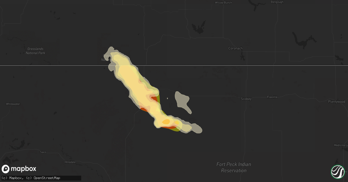
Hail Map in Richland, MT on July 12, 2024
Get this storm
July 12 map
$229
one time, instant access
Download today. No call, no setup
Keep the $229
Bought the map and want the full workflow? Apply the entire $229 to a subscription within 7 days. None of it is wasted.
Every map, not just this one
This buys you this map. Subscription and you get every map we run, in the markets you choose from a few cities to whole states to nationwide. Plus real-time alerts the moment a storm fires.
Contact data
Name, contact info, occupancy, even credit band for addresses in the footprint. You go from where it hit to who to call.
Become the source they trust
Unlimited branding weather history reports on demand. You already have the documented answer ready for the property owner, and you are the one who showed up with it.
Property data and RoofTrace estimates
Pull up any address you have got, its value and the exact code rules for that jurisdiction, straight from One Click Code. Then RoofTrace estimates the squares, pitch, and roof value, priced the way you price.
Storm reports in Richland, MT
Richland, MT
| Date | Description |
|---|---|
| 07/11/20248:25 PM CDT | Significant and widespread crop damage including thousands of acres of corn... Peas... Canola... Wheat... Barley and alfalfa. Photos submitted confirmed large hail most |
| 07/11/20248:15 PM CDT | Damage to multiple farm buildings including a roof completely blown off a barn and some walls knocked down. Wood debris scattered in multiple directions. A circular hay |
All States Impacted by Hail Map on July 12, 2024
All Cities Impacted by Hail Map on July 12, 2024
- Bourbon, MO
- Leasburg, MO
- Greenfield, MO
- Everton, MO
- Dadeville, MO
- Walnut Grove, MO
- Aldrich, MO
- Williamsville, MO
- Morrisville, MO
- Glennie, MI
- Brighton, MO
- Willard, MO
- Mikado, MI
- Enfield, IL
- Houston, TX
- Broughton, IL
- Ozark, IL
- Stonefort, IL
- Norris City, IL
- Simpson, IL
- Naylor, MO
- Carmi, IL
- Green Forest, AR
- Alpena, AR
- Harviell, MO
- Poplar Bluff, MO
- Omaha, IL
- Success, AR
- Golconda, IL
- Grantsburg, IL
- Junction, IL
- Ridgway, IL
- Harrison, AR
- Shawneetown, IL
- Williams, AZ
- Goreville, IL
- Marion, IL
- Pocahontas, AR
- Creal Springs, IL
- Carsonville, MI
- Deckerville, MI
- Du Bois, IL
- Sharon, OK
- Ravenden Springs, AR
- Alamo, ND
- Gatewood, MO
- Scheller, IL
- Ray, ND
- Tamaroa, IL
- Wildrose, ND
- Sesser, IL
- Waltonville, IL
- Seligman, AZ
- Fargo, OK
- Arnett, OK
- Tioga, ND
- Otis, CO
- White Earth, ND
- Los Alamos, NM
- Stanley, ND
- Ross, ND
- Gage, OK
- Ponderosa, NM
- Edwardsville, IL
- Paulden, AZ
- Palermo, ND
- Plaza, ND
- Peach Springs, AZ
- Medora, ND
- Belfield, ND
- Makoti, ND
- Watford City, ND
- Edgewood, NM
- Payson, AZ
- Tijeras, NM
- Ryder, ND
- Killdeer, ND
- Kingman, AZ
- Minot, ND
- Glenburn, ND
- Douglas, ND
- Moorcroft, WY
- Surrey, ND
- Rozet, WY
- Deering, ND
- Norwich, ND
- Upton, WY
- Velva, ND
- Granville, ND
- Bantry, ND
- Upham, ND
- Sundance, WY
- Gordon, NE
- Dunn Center, ND
- Merriman, NE
- Voltaire, ND
- Opheim, MT
- Hinsdale, MT
- Richland, MT
- Larslan, MT
- Belle Fourche, SD
- Glentana, MT
- Gillette, WY
- Turtle Lake, ND
- Osage, WY
- Ruso, ND
- Regent, ND
- Hazen, ND
- Mercer, ND
- Mott, ND
- Peerless, MT
- Coleharbor, ND
- Stanton, ND
- Mcclusky, ND
- Flaxville, MT
- Lance Creek, WY
- Rugby, ND
- Pine Ridge, SD
- Douglas, WY
- New Leipzig, ND
- Oelrichs, SD
- Wolf Point, MT
- Hettinger, ND
- Center, ND
- Bison, SD
- Edgemont, SD
- Meadow, SD
- Selfridge, ND
- Prescott Valley, AZ
- Dupree, SD
- Mandan, ND
- Parshall, ND
- Dagmar, MT
- Harrison, NE
- Lusk, WY
- Grenora, ND
- Fortuna, ND
- Zahl, ND
- Ambrose, ND
- Crosby, ND
- Whitney, NE
- Noonan, ND
- Mcgregor, ND
- Columbus, ND
- Powers Lake, ND
- Crawford, NE
- Chadron, NE
- McIntosh, SD
- Osborne, KS
- Alton, KS
- Carson, ND
- Fullerton, ND
- Marsland, NE
- Natoma, KS
- Waldo, KS
- Isabel, SD
- Timber Lake, SD
- Paradise, KS
- Hemingford, NE
- Hay Springs, NE
- Rushville, NE
- New Town, ND
- Halliday, ND
- Berthold, ND
- Strasburg, ND
- Hague, ND
- Burlington, ND
- Minot Afb, ND
- Maxbass, ND
- Newburg, ND
- Towner, ND
- Fergus Falls, MN
- Elbow Lake, MN
- Otterville, MO
- Bunceton, MO
- Syracuse, MO
- Florence, MO
- Norcross, MN
- Herman, MN
- Barrett, MN
- Carbondale, IL
- Pomona, IL
- Hancock, MN
- Evansville, MN
- Urich, MO
- Butler, MO
- Morris, MN
- Revillo, SD
- Danvers, MN
- Creighton, MO
- Clinton, MO
- Starbuck, MN
- Cyrus, MN
- Gary, SD
- Blairstown, MO
- Glenwood, MN
- Calhoun, MO
- Vergennes, IL
- Montrose, MO
- Welda, KS
- Alexandria, MN
- Fortuna, MO
- Chilhowee, MO
- Lowry City, MO
- Kincaid, KS
- Windsor, MO
- Lincoln, MO
- New Franklin, MO
- Leeton, MO
- Garnett, KS
- Osceola, MO
- Clarkfield, MN
- Boyd, MN
- Appleton City, MO
- Fayette, MO
- Rocheport, MO
- Elkville, IL
- Blue Mound, KS
- Centerville, KS
- Columbia, MO
- Harrisburg, MO
- Deepwater, MO
- El Dorado Springs, MO
- Eldon, MO
- Eugene, MO
- Green Ridge, MO
- Rockville, MO
- Tuscumbia, MO
- Schell City, MO
- Marshall, MO
- Houstonia, MO
- Hughesville, MO
- Iberia, MO
- Ulman, MO
- Blackwater, MO
- Nelson, MO
- Brumley, MO


