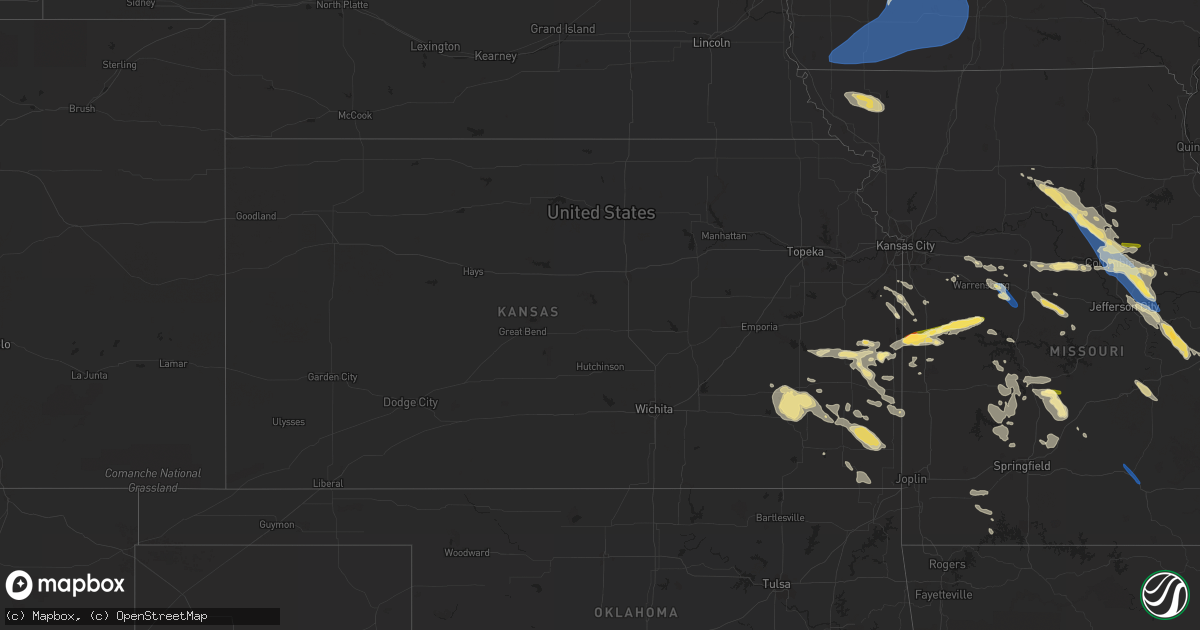
Hail Map in Kansas on July 12, 2023
Get this storm
July 12 map
$229
one time, instant access
Download today. No call, no setup
Keep the $229
Bought the map and want the full workflow? Apply the entire $229 to a subscription within 7 days. None of it is wasted.
Every map, not just this one
This buys you this map. Subscription and you get every map we run, in the markets you choose from a few cities to whole states to nationwide. Plus real-time alerts the moment a storm fires.
Contact data
Name, contact info, occupancy, even credit band for addresses in the footprint. You go from where it hit to who to call.
Become the source they trust
Unlimited branding weather history reports on demand. You already have the documented answer ready for the property owner, and you are the one who showed up with it.
Property data and RoofTrace estimates
Pull up any address you have got, its value and the exact code rules for that jurisdiction, straight from One Click Code. Then RoofTrace estimates the squares, pitch, and roof value, priced the way you price.
Storm reports in Kansas
Kansas
| Date | Description |
|---|---|
| 07/12/20232:30 AM CDT | Ten inch diameter tree is down along with a large limb via a facebook picture. Time is estimated from radar. |
| 07/12/20232:00 AM CDT | Six to eight inch tree limbs downed via facebook picture. Time is estimated. |
| 07/12/20231:50 AM CDT | County dispatch relayed a report of metal shed being crumpled and tossed. Time is estimated from radar. |
| 07/12/20231:32 AM CDT | Trees down and widespread power outages. |
| 07/12/202312:38 AM CDT | Asos station kcnu chanute martin johnson airport. |
| 07/11/202311:40 PM CDT | Trees at least 1ft in diameter down... Power poles snapped. |
| 07/11/202311:36 PM CDT | Multiple trees and power lines down. |
| 07/11/202311:30 PM CDT | Twitter report from chaser. |
| 07/11/20238:11 PM CDT | A local report indicates 1.00 inch wind near 3 NE Mound City |
All States Impacted by Hail Map on July 12, 2023
Cities Impacted by Hail Map on July 12, 2023
- Purdum, NE
- Dunning, NE
- Brewster, NE
- Anselmo, NE
- Broken Bow, NE
- Ansley, NE
- Westerville, NE
- Johnstown, NE
- Mason City, NE
- Litchfield, NE
- Ravenna, NE
- Hazard, NE
- Lacona, IA
- Milo, IA
- Melcher Dallas, IA
- Knoxville, IA
- Columbia, IA
- Chariton, IA
- Lovilia, IA
- Albia, IA
- Imogene, IA
- Clarinda, IA
- Red Oak, IA
- Stanton, IA
- Essex, IA
- Emerson, IA
- Villisca, IA
- Shenandoah, IA
- Farragut, IA
- Northboro, IA
- Coin, IA
- Yorktown, IA
- Cumberland, IA
- Corning, IA
- Nodaway, IA
- Elliott, IA
- Greenfield, IA
- Fontanelle, IA
- Menlo, IA
- Massena, IA
- Bridgewater, IA
- Carbon, IA
- Grant, IA
- Adair, IA
- Casey, IA
- Stuart, IA
- Anita, IA
- Audubon, IA
- Hamlin, IA
- Lewis, IA
- Exira, IA
- Wiota, IA
- Atlantic, IA
- Griswold, IA
- Brayton, IA
- Guthrie Center, IA
- Prescott, IA
- Creston, IA
- Orient, IA
- Winterset, IA
- Dexter, IA
- Cromwell, IA
- New Market, IA
- Blanchard, IA
- Braddyville, IA
- Blockton, IA
- Sharpsburg, IA
- Shambaugh, IA
- Clearfield, IA
- College Springs, IA
- Bedford, IA
- Lenox, IA
- Gravity, IA
- Diagonal, IA
- Benton, IA
- Tingley, IA
- Shannon City, IA
- Afton, IA
- Macksburg, IA
- Mount Ayr, IA
- Lorimor, IA
- Kellerton, IA
- Ellston, IA
- Thayer, IA
- Murray, IA
- Peru, IA
- Earlham, IA
- Searsboro, IA
- Montezuma, IA
- New Sharon, IA
- Barnes City, IA
- Gibson, IA
- Deep River, IA
- Guernsey, IA
- Grand River, IA
- Truro, IA
- Osceola, IA
- Victor, IA
- What Cheer, IA
- Keswick, IA
- Ladora, IA
- Webster, IA
- North English, IA
- Millersburg, IA
- Marengo, IA
- Williamsburg, IA
- South Amana, IA
- Parnell, IA
- Homestead, IA
- Kalona, IA
- Iowa City, IA
- Riverside, IA
- Wellman, IA
- Oxford, IA
- North Liberty, IA
- Tiffin, IA
- Solon, IA
- Coralville, IA
- West Branch, IA
- Tipton, IA
- West Liberty, IA
- Skidmore, MO
- Maryville, MO
- Barnard, MO
- Burlington Junction, MO
- Graham, MO
- Fairfax, MO
- Nassau, NY
- East Nassau, NY
- Brainard, NY
- La Grange, IL
- Berwyn, IL
- Lyons, IL
- Elgin, IL
- Cicero, IL
- South Elgin, IL
- Chicago, IL
- Huntley, IL
- Lake In The Hills, IL
- Palatka, FL
- Salisbury, MO
- Interlachen, FL
- Moberly, MO
- East Greenbush, NY
- Averill Park, NY
- Keytesville, MO
- Floydada, TX
- Crosbyton, TX
- Malabar, FL
- Palm Bay, FL
- Melbourne, FL
- Laceyville, PA
- Meshoppen, PA
- East Chatham, NY
- Old Chatham, NY
- Castleton On Hudson, NY
- Valatie, NY
- Schodack Landing, NY
- Saucier, MS
- Gulfport, MS
- Buckhorn, NM
- Schaumburg, IL
- Elk Grove Village, IL
- Bridgeport, NE
- Angora, NE
- Bayard, NE
- Amsterdam, MO
- Amoret, MO
- Adrian, MO
- Urich, MO
- Butler, MO
- Mound City, KS
- New Bloomfield, MO
- Tebbetts, MO
- Fulton, MO
- Mokane, MO
- Clinton, MO
- Blairstown, MO
- Leasburg, MO
- Cadet, MO
- Belgrade, MO
- Bourbon, MO
- Bonne Terre, MO
- Mineral Point, MO
- Saint Clair, MO
- Gerald, MO
- Potosi, MO
- Richwoods, MO
- Sullivan, MO
- Blackwell, MO
- Steelville, MO
- Leslie, MO
- Beaufort, MO
- Ashland, MO
- Harrisburg, MO
- Bonnots Mill, MO
- Chamois, MO
- Columbia, MO
- Clark, MO
- Holts Summit, MO
- Rocheport, MO
- Hallsville, MO
- Fayette, MO
- Linn, MO
- Armstrong, MO
- Higbee, MO
- Park Hills, MO
- Bismarck, MO
- Irondale, MO
- Belleview, MO
- Caledonia, MO
- Ironton, MO
- Leadwood, MO
- Doe Run, MO
- Farmington, MO
- Knob Noster, MO
- Whiteman Air Force Base, MO
- Green Ridge, MO
- La Monte, MO
- Windsor, MO
- Fredericktown, MO
- Glenallen, MO
- Marquand, MO
- Patton, MO
- Marble Hill, MO
- Leopold, MO
- Tunas, MO
- Eldridge, MO
- Rich Hill, MO
- Wooldridge, MO
- Prairie Home, MO
- Boonville, MO
- Scottsbluff, NE
- Biloxi, MS
- Franklinton, LA
- Goldsmith, TX
- Odessa, TX
- Parker, KS
- Centerville, KS
- Urbana, MO
- Minatare, NE
- Mapleton, KS
- Uniontown, KS
- Bronson, KS
- Warrensburg, MO
- Mayview, MO
- Higginsville, MO
- Odessa, MO
- Blackwater, MO
- Bradley, AR
- Fouke, AR
- Kremlin, MT
- Hume, MO
- Blue Mound, KS
- Columbia, MS
- Garnett, KS
- Bland, MO
- Owensville, MO
- Cuba, MO
- Sumner, MO
- Sturgeon, MO
- Marceline, MO
- Clifton Hill, MO
- Mendon, MO
- Mcadoo, TX
- Benton Harbor, MI
- Watervliet, MI
- Coloma, MI
- Belle, MO
- Vanceboro, ME
- Marshall, MO
- Houstonia, MO
- Pleasanton, KS
- Laclede, MO
- Madison, MO
- Huntsville, MO
- Westphalia, KS
- Jefferson City, MO
- Kincaid, KS
- Welda, KS
- Franklin, GA
- Roanoke, AL
- Montrose, MO
- Foxworth, MS
- Union, MO
- Lonedell, MO
- Whitewater, MO
- Brunswick, MO
- Kingdom City, MO
- Prescott, KS
- Le Roy, KS
- Broadwater, NE
- Buffalo, MO
- Chillicothe, MO
- Steedman, MO
- Burlington, KS
- Colony, KS
- Concordia, MO
- Rothville, MO
- Mountainair, NM
- Thompson, MO
- Centralia, MO
- Mexico, MO
- Mountain Grove, MO
- Cabool, MO
- Willow Springs, MO
- Nelson, MO
- Pilot Grove, MO
- Quincy, MO
- Osceola, MO
- Cohagen, MT
- Toronto, KS
- Yates Center, KS
- Fredonia, KS
- Buffalo, KS
- Sweet Springs, MO
- Fortuna, MO
- Florence, MO
- Conway, MO
- Alliance, NE
- Kingsville, MO
- Pleasant Hill, MO
- Cleveland, MO
- Peculiar, MO
- Belton, MO
- Humboldt, KS
- Iola, KS
- Piqua, KS
- Girard, KS
- Stark, KS
- Walnut, KS
- Foristell, MO
- Fort Scott, KS
- Hepler, KS
- Loose Creek, MO
- Saint James, MO
- Louisburg, MO
- Lebanon, MO
- Phillipsburg, MO
- Windyville, MO
- Long Lane, MO
- Louisburg, KS
- Smithton, MO
- Versailles, MO
- Otterville, MO
- Barnett, MO
- Grovespring, MO
- Aurora, MO
- Virgil, KS
- Stilwell, KS
- Fall River, KS
- Harrisonville, MO
- Paola, KS
- Fulton, KS
- Bolivar, MO
- Holden, MO
- Warsaw, MO
- Cross Timbers, MO
- Macks Creek, MO
- Hermitage, MO
- Preston, MO
- Mora, MO
- Medford, OK
- Saint Paul, KS
- McCune, KS
- Williamsburg, MO
- Chanute, KS
- Arcadia, KS
- Flemington, MO
- Wheatland, MO
- Auxvasse, MO
- Dunnegan, MO
- Pittsburg, MO
- Polk, MO
- Weaubleau, MO
- Stockton, MO
- Humansville, MO
- Fair Play, MO
- Aldrich, MO
- Wright City, MO
- Benedict, KS
- Sedalia, MO
- Syracuse, MO
- Stover, MO
- Shell Knob, MO
- Fair Grove, MO
- Marshfield, MO
- Elkland, MO
- Liberal, MO
- Garland, KS
- Bronaugh, MO
- Freeman, MO
- Spring Hill, KS
- Drexel, MO
- Bucyrus, KS
- Cherokee, KS
- Pittsburg, KS
- Montgomery City, MO
- Weir, KS
- Galesburg, KS
- Erie, KS
- Rosebud, MO
- Morrisville, MO
- Walnut Grove, MO
- Hilliard, FL
- Savonburg, KS
- Redfield, KS
- Colon, MI
- Sherwood, MI
- Carol Stream, IL
- Glendale Heights, IL
- Brady, NE
- Ellsworth, NE
- Hemingford, NE
- Merriman, NE
- Bingham, NE
- Tryon, NE
- Willard, MO
- Jerome, MO
- Duke, MO
- Edgar Springs, MO
- Dixon, MO
- Newburg, MO
- Rolla, MO
- Oshkosh, NE
- Silver City, NM
- Columbus, KS
- Chetopa, KS
- Hughesville, MO
- Ashby, NE
- Oswego, KS
- Parsons, KS
- Stapleton, NE
- Winston, NM
- Arthur, NE
- Half Way, MO
- Hyannis, NE
- Verona, MO
- Whitman, NE
- Westphalia, MO
- Leesburg, OH
- Lakeside, NE
- Gravois Mills, MO
- Mullen, NE
- Cherryvale, KS
- New Vienna, OH
- Greenfield, OH
- Sutherland, NE
- Willowbrook, IL


