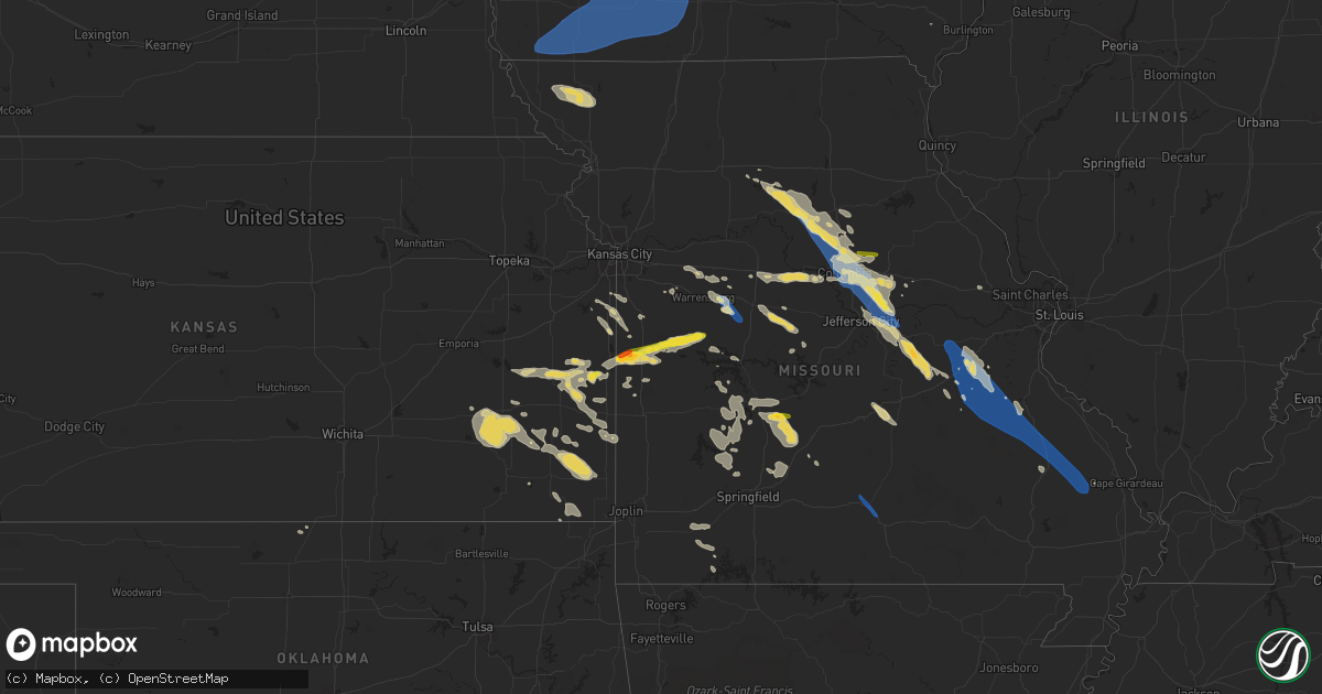
Hail Map on July 12, 2023
Get this storm
July 12 map
$229
one time, instant access
Download today. No call, no setup
Keep the $229
Bought the map and want the full workflow? Apply the entire $229 to a subscription within 7 days. None of it is wasted.
Every map, not just this one
This buys you this map. Subscription and you get every map we run, in the markets you choose from a few cities to whole states to nationwide. Plus real-time alerts the moment a storm fires.
Contact data
Name, contact info, occupancy, even credit band for addresses in the footprint. You go from where it hit to who to call.
Become the source they trust
Unlimited branding weather history reports on demand. You already have the documented answer ready for the property owner, and you are the one who showed up with it.
Property data and RoofTrace estimates
Pull up any address you have got, its value and the exact code rules for that jurisdiction, straight from One Click Code. Then RoofTrace estimates the squares, pitch, and roof value, priced the way you price.
States Impacted by Hail Map on July 12, 2023
Storm reports
Mississippi
| Date | Description |
|---|---|
| 07/12/20236:12 PM CDT | Emergency management reported a tree down on a church on chanse ave near carterville rd. |
| 07/12/20236:11 PM CDT | Local law enforcement reported multiple trees down across jones county. |
| 07/12/20236:10 PM CDT | Local law enforcement reported a few trees down near meadow park lane... And mini farm road. One tree fell on a powerline near monore road. |
Illinois
| Date | Description |
|---|---|
| 07/12/20236:59 PM CDT | Warehouses reported damaged on the west side of ohare airport. Location and time estimated. |
| 07/12/20236:44 PM CDT | Trees snapped and debris lofted. Time estimated. |
| 07/12/20236:23 PM CDT | Large trees 20 inches in diameter down and damage reported to homes... West of elgin... Northeast of campton hills. Location and time estimated. |
| 07/12/20236:23 PM CDT | Video of roof peeled back off building. Debris swirling in air near 47th and harlem. Time estimated by radar. |
| 07/12/20236:20 PM CDT | Photo shared on social media of a structure damaged. Time estimated. |
| 07/12/20236:17 PM CDT | Car windows reported blown out and damage to signs near east ave. Time estimated. |
| 07/12/20236:16 PM CDT | Trees uprooted and roofs blown off near joliet road and lagrange road. Time estimated. |
| 07/12/20236:16 PM CDT | Trees down and damage reported to homes near algonquin and reed roads. Time estimated. |
| 07/12/20236:15 PM CDT | One roof blown off in huntley. Time estimated. |
| 07/12/20235:27 PM CDT | Six inch tree limb down at fox bend golf course. Possible tornado. Time estimated. |
Arkansas
| Date | Description |
|---|---|
| 07/12/20235:16 AM CDT | Drake field |
| 07/12/20234:50 AM CDT | Northwest arkansas regional airport asos observed gust to 63mph. |
| 07/12/20234:40 AM CDT | Trees and tree limbs down across gentry ar. Report relayed via social media. Time is radar estimated. |
Virginia
| Date | Description |
|---|---|
| 07/12/20232:48 AM CDT | Trees down. |
Kansas
| Date | Description |
|---|---|
| 07/12/20232:30 AM CDT | Ten inch diameter tree is down along with a large limb via a facebook picture. Time is estimated from radar. |
| 07/12/20232:00 AM CDT | Six to eight inch tree limbs downed via facebook picture. Time is estimated. |
| 07/12/20231:50 AM CDT | County dispatch relayed a report of metal shed being crumpled and tossed. Time is estimated from radar. |
| 07/12/20231:32 AM CDT | Trees down and widespread power outages. |
| 07/12/202312:38 AM CDT | Asos station kcnu chanute martin johnson airport. |
| 07/11/202311:40 PM CDT | Trees at least 1ft in diameter down... Power poles snapped. |
| 07/11/202311:36 PM CDT | Multiple trees and power lines down. |
| 07/11/202311:30 PM CDT | Twitter report from chaser. |
| 07/11/20238:11 PM CDT | A local report indicates 1.00 inch wind near 3 NE Mound City |
Louisiana
| Date | Description |
|---|---|
| 07/12/20231:31 PM CDT | Lake pontchartrain mesonet reported a gust to 71mph wind gust. |
Pennsylvania
| Date | Description |
|---|---|
| 07/12/20233:37 PM CDT | Trees reported down via county dispatch. Time estimated via radar. |
| 07/12/20233:25 PM CDT | Tree down in the road via county dispatch. Time estimated by radar. |
| 07/12/20233:19 PM CDT | Multiple trees down via broadcast media social media page. Time estimated by radar. |
Michigan
| Date | Description |
|---|---|
| 07/11/202311:11 PM CDT | Image on social media of gas station canopy blown over. Time estimated via radar. |
| 07/11/202311:09 PM CDT | Multiple tree branches and powerlines down across lansing area. |
| 07/11/202311:05 PM CDT | Wind gust at the wlns studio. |
| 07/11/202310:14 PM CDT | Tree down. Time estimated via radar. |
| 07/11/202310:13 PM CDT | Spotter reported barn destroyed... Powerline flashes visible. |
| 07/11/202310:07 PM CDT | Corrects previous tornado report from 2 ese colon. Delayed report. Broadcast media reports several large trees down at a home off of ambs road near m-86. Time estimated |
| 07/11/202310:06 PM CDT | Multiple barns damaged at kane rd and m-86. Reported by emergency management. |
| 07/11/202310:01 PM CDT | Tree down at risk & deitz. Time estimated via radar. |
| 07/11/202310:00 PM CDT | Reports of branches and wires down on m79 near nashville/hastings border. Time estimated via radar. |
| 07/11/20239:42 PM CDT | Multiple trees and wires down in hastings/yankee springs areas. Time estimated via radar. |
| 07/11/20239:31 PM CDT | Tree down. Time estimated via radar. |
| 07/11/20239:14 PM CDT | Tree down. Time estimated via radar. |
| 07/11/20239:14 PM CDT | Tree down. |
| 07/11/20238:25 PM CDT | Greenhouse... Chicken coop... And farm stand blown down. Tree branches down. |
| 07/11/20238:07 PM CDT | Delayed report. Broadcast media reports several large trees down at a home off of ambs road near m-86. Time estimated by radar. |
Iowa
| Date | Description |
|---|---|
| 07/12/20236:32 PM CDT | There is a distinct tornado track through a cornfield approximately 20 yards wide. The track begins in the corn field and seems to end near the road where a couple of b |
| 07/12/20236:28 PM CDT | A tornado impacted a farm on reflection lane. There was significant tree damage... Windows were blown out of the home... And a large barn had nearly all walls collapse |
| 07/12/20236:05 PM CDT | A tornado developed near overton road and 286th street in harrison county iowa. The tornado moved rapidly to the east where it made a direct impact on a home. At this l |
| 07/12/20239:17 AM CDT | Tree branches down over 2 inches diameter. Time estimated from radar. |
| 07/12/20238:56 AM CDT | Tree branches down over 2 inches diameter. Time estimated from radar. |
| 07/12/20238:50 AM CDT | Tree branches down over 2 inches diameter. Time estimated from radar. |
| 07/12/20238:45 AM CDT | Branches reported blown down in locations across johnson county. Chainsaw use not required by emergency management. Time estimated by radar. |
| 07/12/20238:40 AM CDT | Tree branches down over 2 inches diameter. Time estimated from radar. |
| 07/12/20237:55 AM CDT | Trees down on the road. Delayed report. |
| 07/12/20237:50 AM CDT | Tree snapped. Report from social media. |
| 07/12/20237:46 AM CDT | Medium sized tree blown down and blocking the road. Delayed report. Time estimated from radar. |
| 07/12/20237:25 AM CDT | Tree limbs down. Delayed report. |
| 07/12/20237:20 AM CDT | Tree limbs down. Delayed report. |
| 07/12/20237:17 AM CDT | A local report indicates 65 MPH wind near 1 N Fontanelle |
| 07/12/20237:15 AM CDT | Trees blown down at the golf course. |
| 07/12/20237:12 AM CDT | A local report indicates 70 MPH wind near Corning |
| 07/12/20237:00 AM CDT | Delayed report - peak wind at personal weather station. |
New York
| Date | Description |
|---|---|
| 07/12/20234:12 PM CDT | Trees down on fish brook rd. Time estimated by radar. |
| 07/12/20234:09 PM CDT | Tree down on st rt 268. |
| 07/12/20234:09 PM CDT | Tree down on st rt 268. |
| 07/12/20233:15 PM CDT | Tree down on wires on chatham st near the fire dept. |
Maine
| Date | Description |
|---|---|
| 07/12/20234:35 PM CDT | Delayed report: broadcast meteorologists reported a large tree down on allen road. Time estimated by radar. |
| 07/12/20234:17 PM CDT | Tree down on powerlines blocking davis st |
| 07/12/20234:15 PM CDT | Corrects previous tstm wnd dmg report from 1 nnw brownville junction. Tree down on powerlines. Power is out in the area. Time estimated on radar. |
| 07/12/20233:34 PM CDT | Tree down on powerlines. Power is out in the area. Time estimated on radar. |
| 07/12/20233:12 PM CDT | Correction to thunderstorm wind damage. Large tree down blocking katahdin iron works road |
Missouri
| Date | Description |
|---|---|
| 07/12/20236:48 PM CDT | Several large tree limbs blow down. Pictures via facebook. |
| 07/12/20236:42 PM CDT | Tree on a house near ash street and greenwood. Powerlines reported down. Report courtesy of abc-17. |
| 07/12/20236:42 PM CDT | Several reports of trees down in the columbia area according to boone county 911 joint comms center. Time estimated by radar. |
| 07/12/20236:37 PM CDT | Powerlines down at the 5400 block of highway z. Time estimated by radar. |
| 07/12/20236:27 PM CDT | Large tree down just off highway c near county road 400. Time estimated by radar. |
| 07/12/20235:30 PM CDT | Powerlines and trees down. |
| 07/12/20238:30 AM CDT | Rockin jh diesel. |
| 07/12/20232:30 AM CDT | Tree down across highway 17. |
| 07/12/20232:04 AM CDT | Multiple trees were blown over or snapped and numerous limbs were downed along a path from geneva street to the northeast along zell road. Several small out buildings s |
| 07/12/20231:52 AM CDT | Trees down and power outages. |
| 07/12/20231:45 AM CDT | Several power poles were pushed over blocking traffic. Multiple electric customers were without power. |
| 07/12/20231:05 AM CDT | Time estimated by radar. |
| 07/12/20231:04 AM CDT | Delayed report. Large tree snapped. Time estimated from radar. |
| 07/12/20231:00 AM CDT | Multiple large trees were uprooted or snapped. Shingle and siding damage occurred to 7 to 10 out buildings and homes. |
| 07/12/202312:52 AM CDT | Joplin airport asos reported 64 mph wind gust. |
| 07/11/202310:45 PM CDT | Tree branches down. Time estimated via radar. |
| 07/11/202310:17 PM CDT | Report from mping: 3-inch tree limbs broken; power poles broken. |
| 07/11/202310:10 PM CDT | A large tree was blown down onto highway c about 4 miles southwest of cherokee pass. |
| 07/11/202310:06 PM CDT | Several large tree limbs blown down around town as well as power lines. |
| 07/11/202310:00 PM CDT | A local report indicates 60 MPH wind near Green Ridge |
| 07/11/20239:49 PM CDT | Reports of extensive tree damage south of knob noster. |
| 07/11/20239:49 PM CDT | A local report indicates 59 MPH wind near Sedalia Memorial Arpt |
| 07/11/20239:49 PM CDT | Awos station kszl whiteman afb. |
| 07/11/20239:47 PM CDT | Observation reported at whiteman afb. |
| 07/11/20239:36 PM CDT | Several power lines and power poles down around town. Also... Several large trees and numerous tree limbs blown down. |
| 07/11/20239:29 PM CDT | Also reported trees down across the city. |
| 07/11/20239:26 PM CDT | Corrects time of previous tstm wnd gst report from desloge. Also reported trees down across the city. |
| 07/11/20239:25 PM CDT | Roof damage to an apartment building. |
| 07/11/20239:23 PM CDT | Law enforcement they were responding to a report of a person trapped in their home due to a tree than had fallen on the residence. The officer stated that several trees |
| 07/11/20239:23 PM CDT | Updated information- residence was located off first street and included 5 occupants. None of the occupants were injured. Previous information- law enforcement said the |
| 07/11/20238:56 PM CDT | Spotter estimated winds near 60 mph 4 miles north of potosi. |
| 07/11/20238:53 PM CDT | A local report indicates 60 MPH wind near Adrian |
| 07/11/20238:53 PM CDT | 8 inch tree limb down. |
| 07/11/20238:39 PM CDT | Reports of golf ball sized hail and and tree damage. |
| 07/11/20238:35 PM CDT | A local report indicates 58 MPH wind near Cuba |
| 07/11/20238:34 PM CDT | Large tree down blocking hwy 89 south of linn mo. Also a power pole down east of town. Time estimated by radar. |
| 07/11/20238:20 PM CDT | Corrected previous location of the report. Report was relayed via email with photos including the location to be off springfield road outside sullivan mo. Spotter repor |
| 07/11/20238:20 PM CDT | Tree partially over hwy 185 near the high school near meramec state park. Time estimated by radar. |
| 07/11/20238:20 PM CDT | Spotter report a 1 ft diameter tree down on a trail northeast of sullivan. |
| 07/11/20238:14 PM CDT | Spotter located just north of i-44 off overland drive estimated winds to be 60-70 mph. Tree limbs down estimated to be 2-3 inches in diameter. |
| 07/11/20238:12 PM CDT | Trees down near intersection of highway v and tappmeyer road. |
| 07/11/20238:10 PM CDT | Trees were blown down near the intersection of highway cc and canaan road. |
| 07/11/20238:06 PM CDT | Flag pole at bland fire department was blown over. |
| 07/11/20237:37 PM CDT | Spotter reported a tree down on a car off starboard drive. A tree had also fallen on a residence off dulles court. Several other reports of tree damage and powerline do |
| 07/11/20237:27 PM CDT | Osage county em stated that trees were reported down across the railroad tracks in bonnots mill along the missouri river. |
| 07/11/20237:14 PM CDT | Small branches also reported down. |
| 07/11/20237:02 PM CDT | Callaway county em relayed a report of roof damage to a residence near county road 334 and shelly drive. |
Texas
| Date | Description |
|---|---|
| 07/12/20235:29 PM CDT | West texas mesonet. A few severe-caliber wind gusts were measured between 520 pm and 530 pm cdt... With the highest gust peaking at 72 mph. |
| 07/12/20234:45 PM CDT | Mesonet station fw9692 pecos. |
Nebraska
| Date | Description |
|---|---|
| 07/12/20237:31 AM CDT | A local report indicates 58 MPH wind near Burchard |
| 07/12/20237:15 AM CDT | Corrects previous tstm wnd gst report from burchard. |
| 07/11/20238:23 PM CDT | A local report indicates 1.75 inch wind near 7 S Angora |
| 07/11/20238:15 PM CDT | Twitter report of 1.5 inch hail. |
| 07/11/20237:47 PM CDT | Lasted around 5 minutes. |
| 07/11/20237:44 PM CDT | A local report indicates 1.75 inch wind near 9 N Minatare |
Cities Impacted by Hail Map on July 12, 2023
- Purdum, NE
- Dunning, NE
- Brewster, NE
- Anselmo, NE
- Broken Bow, NE
- Ansley, NE
- Westerville, NE
- Johnstown, NE
- Mason City, NE
- Litchfield, NE
- Ravenna, NE
- Hazard, NE
- Lacona, IA
- Milo, IA
- Melcher Dallas, IA
- Knoxville, IA
- Columbia, IA
- Chariton, IA
- Lovilia, IA
- Albia, IA
- Imogene, IA
- Clarinda, IA
- Red Oak, IA
- Stanton, IA
- Essex, IA
- Emerson, IA
- Villisca, IA
- Shenandoah, IA
- Farragut, IA
- Northboro, IA
- Coin, IA
- Yorktown, IA
- Cumberland, IA
- Corning, IA
- Nodaway, IA
- Elliott, IA
- Greenfield, IA
- Fontanelle, IA
- Menlo, IA
- Massena, IA
- Bridgewater, IA
- Carbon, IA
- Grant, IA
- Adair, IA
- Casey, IA
- Stuart, IA
- Anita, IA
- Audubon, IA
- Hamlin, IA
- Lewis, IA
- Exira, IA
- Wiota, IA
- Atlantic, IA
- Griswold, IA
- Brayton, IA
- Guthrie Center, IA
- Prescott, IA
- Creston, IA
- Orient, IA
- Winterset, IA
- Dexter, IA
- Cromwell, IA
- New Market, IA
- Blanchard, IA
- Braddyville, IA
- Blockton, IA
- Sharpsburg, IA
- Shambaugh, IA
- Clearfield, IA
- College Springs, IA
- Bedford, IA
- Lenox, IA
- Gravity, IA
- Diagonal, IA
- Benton, IA
- Tingley, IA
- Shannon City, IA
- Afton, IA
- Macksburg, IA
- Mount Ayr, IA
- Lorimor, IA
- Kellerton, IA
- Ellston, IA
- Thayer, IA
- Murray, IA
- Peru, IA
- Earlham, IA
- Searsboro, IA
- Montezuma, IA
- New Sharon, IA
- Barnes City, IA
- Gibson, IA
- Deep River, IA
- Guernsey, IA
- Grand River, IA
- Truro, IA
- Osceola, IA
- Victor, IA
- What Cheer, IA
- Keswick, IA
- Ladora, IA
- Webster, IA
- North English, IA
- Millersburg, IA
- Marengo, IA
- Williamsburg, IA
- South Amana, IA
- Parnell, IA
- Homestead, IA
- Kalona, IA
- Iowa City, IA
- Riverside, IA
- Wellman, IA
- Oxford, IA
- North Liberty, IA
- Tiffin, IA
- Solon, IA
- Coralville, IA
- West Branch, IA
- Tipton, IA
- West Liberty, IA
- Skidmore, MO
- Maryville, MO
- Barnard, MO
- Burlington Junction, MO
- Graham, MO
- Fairfax, MO
- Nassau, NY
- East Nassau, NY
- Brainard, NY
- La Grange, IL
- Berwyn, IL
- Lyons, IL
- Elgin, IL
- Cicero, IL
- South Elgin, IL
- Chicago, IL
- Huntley, IL
- Lake In The Hills, IL
- Palatka, FL
- Salisbury, MO
- Interlachen, FL
- Moberly, MO
- East Greenbush, NY
- Averill Park, NY
- Keytesville, MO
- Floydada, TX
- Crosbyton, TX
- Malabar, FL
- Palm Bay, FL
- Melbourne, FL
- Laceyville, PA
- Meshoppen, PA
- East Chatham, NY
- Old Chatham, NY
- Castleton On Hudson, NY
- Valatie, NY
- Schodack Landing, NY
- Saucier, MS
- Gulfport, MS
- Buckhorn, NM
- Schaumburg, IL
- Elk Grove Village, IL
- Bridgeport, NE
- Angora, NE
- Bayard, NE
- Amsterdam, MO
- Amoret, MO
- Adrian, MO
- Urich, MO
- Butler, MO
- Mound City, KS
- New Bloomfield, MO
- Tebbetts, MO
- Fulton, MO
- Mokane, MO
- Clinton, MO
- Blairstown, MO
- Leasburg, MO
- Cadet, MO
- Belgrade, MO
- Bourbon, MO
- Bonne Terre, MO
- Mineral Point, MO
- Saint Clair, MO
- Gerald, MO
- Potosi, MO
- Richwoods, MO
- Sullivan, MO
- Blackwell, MO
- Steelville, MO
- Leslie, MO
- Beaufort, MO
- Ashland, MO
- Harrisburg, MO
- Bonnots Mill, MO
- Chamois, MO
- Columbia, MO
- Clark, MO
- Holts Summit, MO
- Rocheport, MO
- Hallsville, MO
- Fayette, MO
- Linn, MO
- Armstrong, MO
- Higbee, MO
- Park Hills, MO
- Bismarck, MO
- Irondale, MO
- Belleview, MO
- Caledonia, MO
- Ironton, MO
- Leadwood, MO
- Doe Run, MO
- Farmington, MO
- Knob Noster, MO
- Whiteman Air Force Base, MO
- Green Ridge, MO
- La Monte, MO
- Windsor, MO
- Fredericktown, MO
- Glenallen, MO
- Marquand, MO
- Patton, MO
- Marble Hill, MO
- Leopold, MO
- Tunas, MO
- Eldridge, MO
- Rich Hill, MO
- Wooldridge, MO
- Prairie Home, MO
- Boonville, MO
- Scottsbluff, NE
- Biloxi, MS
- Franklinton, LA
- Goldsmith, TX
- Odessa, TX
- Parker, KS
- Centerville, KS
- Urbana, MO
- Minatare, NE
- Mapleton, KS
- Uniontown, KS
- Bronson, KS
- Warrensburg, MO
- Mayview, MO
- Higginsville, MO
- Odessa, MO
- Blackwater, MO
- Bradley, AR
- Fouke, AR
- Kremlin, MT
- Hume, MO
- Blue Mound, KS
- Columbia, MS
- Garnett, KS
- Bland, MO
- Owensville, MO
- Cuba, MO
- Sumner, MO
- Sturgeon, MO
- Marceline, MO
- Clifton Hill, MO
- Mendon, MO
- Mcadoo, TX
- Benton Harbor, MI
- Watervliet, MI
- Coloma, MI
- Belle, MO
- Vanceboro, ME
- Marshall, MO
- Houstonia, MO
- Pleasanton, KS
- Laclede, MO
- Madison, MO
- Huntsville, MO
- Westphalia, KS
- Jefferson City, MO
- Kincaid, KS
- Welda, KS
- Franklin, GA
- Roanoke, AL
- Montrose, MO
- Foxworth, MS
- Union, MO
- Lonedell, MO
- Whitewater, MO
- Brunswick, MO
- Kingdom City, MO
- Prescott, KS
- Le Roy, KS
- Broadwater, NE
- Buffalo, MO
- Chillicothe, MO
- Steedman, MO
- Burlington, KS
- Colony, KS
- Concordia, MO
- Rothville, MO
- Mountainair, NM
- Thompson, MO
- Centralia, MO
- Mexico, MO
- Mountain Grove, MO
- Cabool, MO
- Willow Springs, MO
- Nelson, MO
- Pilot Grove, MO
- Quincy, MO
- Osceola, MO
- Cohagen, MT
- Toronto, KS
- Yates Center, KS
- Fredonia, KS
- Buffalo, KS
- Sweet Springs, MO
- Fortuna, MO
- Florence, MO
- Conway, MO
- Alliance, NE
- Kingsville, MO
- Pleasant Hill, MO
- Cleveland, MO
- Peculiar, MO
- Belton, MO
- Humboldt, KS
- Iola, KS
- Piqua, KS
- Girard, KS
- Stark, KS
- Walnut, KS
- Foristell, MO
- Fort Scott, KS
- Hepler, KS
- Loose Creek, MO
- Saint James, MO
- Louisburg, MO
- Lebanon, MO
- Phillipsburg, MO
- Windyville, MO
- Long Lane, MO
- Louisburg, KS
- Smithton, MO
- Versailles, MO
- Otterville, MO
- Barnett, MO
- Grovespring, MO
- Aurora, MO
- Virgil, KS
- Stilwell, KS
- Fall River, KS
- Harrisonville, MO
- Paola, KS
- Fulton, KS
- Bolivar, MO
- Holden, MO
- Warsaw, MO
- Cross Timbers, MO
- Macks Creek, MO
- Hermitage, MO
- Preston, MO
- Mora, MO
- Medford, OK
- Saint Paul, KS
- McCune, KS
- Williamsburg, MO
- Chanute, KS
- Arcadia, KS
- Flemington, MO
- Wheatland, MO
- Auxvasse, MO
- Dunnegan, MO
- Pittsburg, MO
- Polk, MO
- Weaubleau, MO
- Stockton, MO
- Humansville, MO
- Fair Play, MO
- Aldrich, MO
- Wright City, MO
- Benedict, KS
- Sedalia, MO
- Syracuse, MO
- Stover, MO
- Shell Knob, MO
- Fair Grove, MO
- Marshfield, MO
- Elkland, MO
- Liberal, MO
- Garland, KS
- Bronaugh, MO
- Freeman, MO
- Spring Hill, KS
- Drexel, MO
- Bucyrus, KS
- Cherokee, KS
- Pittsburg, KS
- Montgomery City, MO
- Weir, KS
- Galesburg, KS
- Erie, KS
- Rosebud, MO
- Morrisville, MO
- Walnut Grove, MO
- Hilliard, FL
- Savonburg, KS
- Redfield, KS
- Colon, MI
- Sherwood, MI
- Carol Stream, IL
- Glendale Heights, IL
- Brady, NE
- Ellsworth, NE
- Hemingford, NE
- Merriman, NE
- Bingham, NE
- Tryon, NE
- Willard, MO
- Jerome, MO
- Duke, MO
- Edgar Springs, MO
- Dixon, MO
- Newburg, MO
- Rolla, MO
- Oshkosh, NE
- Silver City, NM
- Columbus, KS
- Chetopa, KS
- Hughesville, MO
- Ashby, NE
- Oswego, KS
- Parsons, KS
- Stapleton, NE
- Winston, NM
- Arthur, NE
- Half Way, MO
- Hyannis, NE
- Verona, MO
- Whitman, NE
- Westphalia, MO
- Leesburg, OH
- Lakeside, NE
- Gravois Mills, MO
- Mullen, NE
- Cherryvale, KS
- New Vienna, OH
- Greenfield, OH
- Sutherland, NE
- Willowbrook, IL