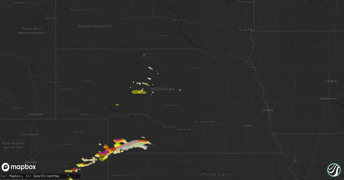
Hail Map in Nebraska on July 12, 2020
Get this storm
July 12 map
$229
one time, instant access
Download today. No call, no setup
Keep the $229
Bought the map and want the full workflow? Apply the entire $229 to a subscription within 7 days. None of it is wasted.
Every map, not just this one
This buys you this map. Subscription and you get every map we run, in the markets you choose from a few cities to whole states to nationwide. Plus real-time alerts the moment a storm fires.
Contact data
Name, contact info, occupancy, even credit band for addresses in the footprint. You go from where it hit to who to call.
Become the source they trust
Unlimited branding weather history reports on demand. You already have the documented answer ready for the property owner, and you are the one who showed up with it.
Property data and RoofTrace estimates
Pull up any address you have got, its value and the exact code rules for that jurisdiction, straight from One Click Code. Then RoofTrace estimates the squares, pitch, and roof value, priced the way you price.
Storm reports in Nebraska
Nebraska
| Date | Description |
|---|---|
| 07/12/20206:58 PM CDT | Occurred with 1 inch hail. |
| 07/12/20206:58 PM CDT | Occurred with 70 mph wind gusts. |
| 07/12/20206:53 PM CDT | A local report indicates 2.50 inch wind near 7 S IMPERIAL |
| 07/12/20206:37 PM CDT | Mature pine tree was blown over. Estimated time of report from radar. |
| 07/12/20206:30 PM CDT | Half of a locus tree was broken off in town... Another tree was uprooted. |
| 07/12/20206:30 PM CDT | Atleast 2 power poles leaning from the wind... 6 inch diameter tree limb blown down. Estimated time of report from radar. |
| 07/12/20206:10 PM CDT | A local report indicates 60 MPH wind near HAIGLER |
| 07/12/20206:03 PM CDT | 5 inch diameter tree limb blown down. Estimated time of report from radar. |
| 07/12/20206:03 PM CDT | Estimated time of report from radar. |
| 07/12/202011:00 AM CDT | A local report indicates 1.75 inch wind near SENECA |
| 07/12/202010:55 AM CDT | Picture via social media. |
| 07/12/202010:30 AM CDT | Two separate reports of quarter to ping pong ball hail ongoing in thedford. |
| 07/12/20206:16 AM CDT | At 1114 AM CDT/1014 AM MDT/, a severe thunderstorm was located near Seneca, or 10 miles northwest of Thedford, moving east at 25 mph. HAZARD...Golf ball size hail. SOURCE...Public. IMPACT...People and animals outdoors will be injured. Expect damage to roofs, siding, windows, and vehicles. Locations impacted include... Thedford, Seneca, Natwick and Norway. This includes the following highways... Highway 2 between mile markers 194 and 224. Highway 83 between mile markers 142 and 158. |
| 07/12/20205:31 AM CDT | At 1031 AM CDT/931 AM MDT/, a severe thunderstorm was located near Mullen, moving east at 25 mph. HAZARD...Ping pong ball size hail and 60 mph wind gusts. SOURCE...Radar indicated. IMPACT...People and animals outdoors will be injured. Expect hail damage to roofs, siding, windows, and vehicles. Expect wind damage to roofs, siding, and trees. Locations impacted include... Mullen, Thedford, Seneca, Highway 83 crossing The Dismal River, Norway, Natwick and Kelso.This includes the following highways... Highway 2 between mile markers 181 and 221. Highway 97 between mile markers 60 and 76. Highway 83 between mile markers 132 and 159. |
| 07/12/20203:15 AM CDT | At 814 PM CDT, a severe thunderstorm was located near Indianola, or 13 miles northeast of McCook, moving east at 35 mph. HAZARD...Ping pong ball size hail and 60 mph wind gusts. SOURCE...Trained weather spotters. IMPACT...People and animals outdoors will be injured. Expect hail damage to roofs, siding, windows, and vehicles. Expect wind damage to roofs, siding, and trees. Locations impacted include... Cambridge, Arapahoe, Beaver City, Holbrook, Wilsonville and Hendley. |
| 07/12/20202:29 AM CDT | At 729 PM CDT, severe thunderstorms were located along a line extending from 14 miles south of Enders Reservoir State Recreation Area to 3 miles northeast of Benkelman to 15 miles northwest of McDonald to 8 miles north of Bird City, moving northeast at 40 mph. HAZARD...70 mph wind gusts and ping pong ball size hail. SOURCE...Radar indicated. IMPACT...People and animals outdoors will be injured. Expect hail damage to roofs, siding, windows, and vehicles. Expect considerable tree damage. Wind damage is also likely to mobile homes, roofs, and outbuildings. Locations impacted include... McCook, Trenton, Culbertson, Palisade and Stratton. |
| 07/12/20202:25 AM CDT | At 725 PM CDT, a severe thunderstorm was located near Palisade, or 9 miles south of Hayes Center, moving east at 40 mph. HAZARD...Ping pong ball size hail and 60 mph wind gusts. SOURCE...Radar indicated. IMPACT...People and animals outdoors will be injured. Expect hail damage to roofs, siding, windows, and vehicles. Expect wind damage to roofs, siding, and trees. Locations impacted include... Stockville, Quick, Bluegill Haven Campground, Willow View Campground, Freedom and Red Willow Reservoir State Recreation Area.This includes Highway 83 between mile markers 27 and 38. |
| 07/12/20201:46 AM CDT | At 646 PM CDT/546 PM MDT/, a severe thunderstorm was located near Champion, or 9 miles south of Imperial, moving east at 20 mph. HAZARD...Two inch hail and 60 mph wind gusts. SOURCE...Radar indicated. IMPACT...People and animals outdoors will be injured. Expect hail damage to roofs, siding, windows, and vehicles. Expect wind damage to roofs, siding, and trees. Locations impacted include... Wauneta, Enders, Enders Reservoir State Recreation Area, Champion, Hamlet, Center Dam Campground, Area A Campground and Church Grove Campground.This includes Highway 61 between mile markers 25 and 30. |
| 07/11/202011:27 PM CDT | At 426 PM MDT, a severe thunderstorm was located 12 miles north of Wray, moving east at 30 mph. HAZARD...60 mph wind gusts and half dollar size hail. SOURCE...Radar indicated. IMPACT...Hail damage to vehicles is expected. Expect wind damage to roofs, siding, and trees. Locations impacted include... Alvin and Wauneta. This includes Highway 385 between mile markers 252 and 262. |
| 07/11/20207:58 PM CDT | A local report indicates 58 MPH wind near 1 E MCCOOK |
| 07/11/20207:54 PM CDT | A local report indicates 91 MPH wind near 4 S MCCOOK |
| 07/11/20207:45 PM CDT | Two car garage door and window blown out. Estimated time of report from radar. |
| 07/11/20207:42 PM CDT | A local report indicates 1.75 inch wind near 16 SE HAYES CENTER |
| 07/11/20207:40 PM CDT | A local report indicates 1.50 inch wind near 7 NNE CULBERTSON |
| 07/11/20207:33 PM CDT | At least 50 mph winds also observed at this time. |
| 07/11/20207:30 PM CDT | Power outage reported in stratton... Culbertson... Trenton... And palisade. |
| 07/11/20207:20 PM CDT | A local report indicates 65 MPH wind near 3 WNW TRENTON |
| 07/11/20207:17 PM CDT | Hail ranged from dime to quarter size. |
| 07/11/20207:17 PM CDT | Two double pane windows on west side of house blown out from wind and 1 inch hail. Estimated time of report from radar. |
| 07/11/20207:17 PM CDT | Estimated time of report from radar. |
| 07/11/20207:08 PM CDT | Corn crop stripped of all its leaves. Estimated time of report from radar. |
| 07/11/20207:06 PM CDT | A local report indicates 2.50 inch wind near 6 S ENDERS |
| 07/11/20207:01 PM CDT | Delayed report with photo via social media. Time estimated by radar. |
All States Impacted by Hail Map on July 12, 2020
Cities Impacted by Hail Map on July 12, 2020
- Hugo, CO
- Shawnee, OK
- Tecumseh, OK
- Bay Minette, AL
- Colorado Springs, CO
- Saint Francis, KS
- Owingsville, KY
- Springfield, KY
- Wray, CO
- Vernon, CO
- Haigler, NE
- Mullen, NE
- Sheffield, AL
- Cherokee, AL
- Florence, AL
- Tuscumbia, AL
- Arriba, CO
- Meridian, MS
- Huntington, IN
- Brookwood, AL
- Vossburg, MS
- Paulding, MS
- Shubuta, MS
- Heidelberg, MS
- Oakley, KS
- Hoxie, KS
- Grinnell, KS
- Trenton, NE
- Maywood, NE
- McCook, NE
- Culbertson, NE
- Palisade, NE
- Benkelman, NE
- Parks, NE
- Arnett, OK
- Thorsby, AL
- Maplesville, AL
- Jemison, AL
- Huntertown, IN
- Fort Wayne, IN
- Beatrice, AL
- Camden, AL
- Monroeville, AL
- Watonga, OK
- Finleyville, PA
- Wing, AL
- Daphne, AL
- Loxley, AL
- Silverhill, AL
- Robertsdale, AL
- Perth, ND
- Chicago Heights, IL
- Crete, IL
- Dyer, IN
- Cope, CO
- Pueblo, CO
- Troy, IN
- Tell City, IN
- Tennyson, IN
- Lewisport, KY
- Derby, IN
- Chrisney, IN
- Cannelton, IN
- Hawesville, KY
- Grandview, IN
- Evanston, IN
- Lamar, IN
- Fayette, AL
- Courtland, MS
- Batesville, MS
- Eckley, CO
- Flagler, CO
- Haleyville, AL
- Lynn, AL
- Selmer, TN
- Laurel, MS
- Seneca, NE
- Sheridan Lake, CO
- Fort Recovery, OH
- Huron, TN
- Oakwood, OK
- Canon City, CO
- Penrose, CO
- Marion, MS
- Natchez, MS
- Guthrie, OK
- Peridot, AZ
- Wagon Mound, NM
- Miami, NM
- Ethridge, TN
- Summertown, TN
- Lynnville, TN
- Thedford, NE
- Anton, CO
- Brandenburg, KY
- Laconia, IN
- Okarche, OK
- Brilliant, AL
- Spruce Pine, AL
- Hackleburg, AL
- Double Springs, AL
- Phil Campbell, AL
- Bear Creek, AL
- Danville, AL
- Moulton, AL
- Cheyenne Wells, CO
- Seiling, OK
- Canton, OK
- Russellville, AL
- Model, CO
- Trinidad, CO
- Sweet Water, AL
- Branson, CO
- Martin, SD
- Sardis, TN
- Saltillo, TN
- Imperial, NE
- Enders, NE
- Wauneta, NE
- Burwell, NE
- Idalia, CO
- Long Valley, SD
- West Liberty, KY
- Rocky Ford, CO
- Peterman, AL
- Evergreen, AL
- Harrah, OK
- Mcloud, OK
- Newalla, OK
- Weskan, KS
- Arapahoe, CO
- Hayes Center, NE
- Max, NE
- Indianola, NE
- Stratton, NE
- Valentine, NE
- Arlington, AL
- Guntown, MS
- Kim, CO
- Parmelee, SD
- South Park, PA
- Venetia, PA
- Crescent, OK
- Holly, CO
- Millport, AL
- Ethelsville, AL
- Vredenburgh, AL
- Norris, SD
- Stanton, KY
- Slade, KY
- Forest, MS
- Lawrence, MS
- Lake, MS
- Eloy, AZ
- Decatur, IN
- Tribune, KS
- Payneville, KY
- Printer, KY
- Hueysville, KY
- Drift, KY
- Eastern, KY
- Langley, KY
- Champion, NE
- Clifton, TN
- Waynesboro, TN
- Quitman, MS
- Adamsville, TN
- Brewton, AL
- Alexander City, AL
- Rockford, AL
- Equality, AL
- Stantonville, TN
- Genoa, CO
- Limon, CO
- Hennessey, OK
- Scotts Hill, TN
- Decaturville, TN
- Safford, AL
- Wilmington, OH
- Blanchester, OH
- Clarksville, OH
- Waterloo, AL
- Counce, TN
- Savannah, TN
- Michie, TN
- Shiloh, TN
- Sharon Springs, KS
- Ebensburg, PA
- Luther, OK
- Jones, OK
- Hasty, CO
- McKee, KY
- Mount Hope, AL
- York, AL
- Cuba, AL
- Joes, CO
- Morris Chapel, TN
- Reagan, TN
- Carbon Hill, AL
- Nauvoo, AL
- Mount Pleasant, TN
- Seminary, MS
- Moselle, MS
- Wanblee, SD
- Leedey, OK
- Milledgeville, TN
- Stapleton, NE
- Charleston, WV
- Plantersville, AL
- Jones, AL
- Billingsley, AL
- Autaugaville, AL
- Salyersville, KY
- Linden, AL
- Enterprise, MS
- Magnolia, AL
- Dixons Mills, AL
- Thomasville, AL
- Avondale, CO
- Ripley, MS
- Alberta, AL
- Yuma, CO
- Akron, CO
- Fairhope, AL
- Kitts Hill, OH
- Willow Wood, OH
- Pedro, OH
- Halsey, NE
- Osteen, FL
- Eads, CO
- Cottondale, AL
- Roy, NM
- Jackson, KY
- Whick, KY
- Lost Creek, KY
- Duncanville, AL
- Mauckport, IN
- Mills, NM
- Lavinia, TN
- Cedar Grove, TN
- Crump, TN
- Johnstown, NE
- Louin, MS
- Waynesboro, MS
- Westport, TN
- Shattuck, OK
- Follett, TX
- Higgins, TX
- Tyner, KY
- Richton, MS
- Grainfield, KS
- Gove, KS
- Saint Cloud, FL
- Meeker, OK
- Linden, TN
- Frenchburg, KY
- Hattiesburg, MS
- Purvis, MS
- Tuscaloosa, AL
- Pine Hill, AL
- Centreville, AL
- Brent, AL
- Balko, OK
- Booker, TX
- Lower Peach Tree, AL
- Stapleton, AL
- Frostproof, FL
- Colby, KS
- Raton, NM
- Coy, AL
- Summerdale, AL
- Lexington, TN
- Beech Bluff, TN
- Whatley, AL
- Dickinson, AL
- Franklin, AL
- Schererville, IN
- Camargo, OK
- Milton, FL
- Jay, FL
- Nettleton, MS
- Fulton, MS
- Hegins, PA
- Ashland, PA
- Pachuta, MS
- Rose Hill, MS
- Marks, MS
- Wetmore, CO
- Ivel, KY
- Tram, KY
- Mount Vernon, KY
- Scottown, OH
- Ironton, OH
- Saint Henry, OH
- Beaumont, MS
- Yuma, TN
- Luray, TN
- Prague, OK
- Bluffton, IN
- Uniondale, IN
- Markle, IN
- Hodgenville, KY
- Steens, MS
- Enville, TN
- Marion, AL
- Granada, CO
- Minter, AL
- Warren, IN
- Moundville, AL
- Greensboro, AL
- Woodrow, CO
- Protection, KS
- Coldwater, KS
- Minneola, KS
- Columbus, GA
- Midland, GA
- Arthur, NE
- Trafford, AL
- Hayden, AL
- Hanceville, AL
- Cleveland, AL
- Locust Fork, AL
- Cullman, AL
- Parrish, AL
- Quinton, AL
- Jasper, AL
- Cordova, AL
- Pelham, AL
- Bessemer, AL
- Fairfield, AL
- Pleasant Grove, AL
- Mulga, AL
- Birmingham, AL
- Helena, AL
- Dolomite, AL
- Kellyton, AL
- Goodwater, AL
- Dadeville, AL
- Jacksons Gap, AL
- Daviston, AL
- Marbury, AL
- Verbena, AL
- Clanton, AL
- Chunchula, AL
- Citronelle, AL
- Fairfield, ND
- Medora, ND
- Dickinson, ND
- Manning, ND
- Sentinel Butte, ND
- Belfield, ND
- Freedom, OK
- Buffalo, OK
- Vici, OK
- Sharon, OK
- Taloga, OK
- Kingfisher, OK
- Loyal, OK
- Elizabeth, IN
- Rexford, KS


