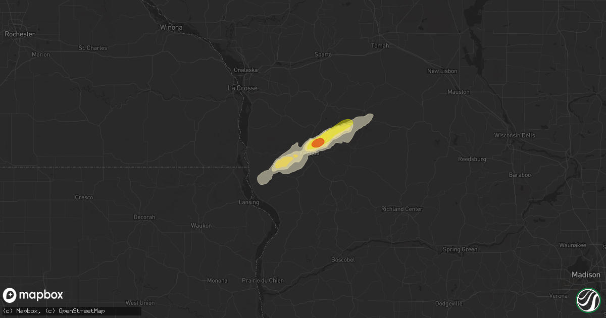
Hail Map in Viroqua, WI on July 12, 2017
Get this storm
July 12 map
$229
one time, instant access
Download today. No call, no setup
Keep the $229
Bought the map and want the full workflow? Apply the entire $229 to a subscription within 7 days. None of it is wasted.
Every map, not just this one
This buys you this map. Subscription and you get every map we run, in the markets you choose from a few cities to whole states to nationwide. Plus real-time alerts the moment a storm fires.
Contact data
Name, contact info, occupancy, even credit band for addresses in the footprint. You go from where it hit to who to call.
Become the source they trust
Unlimited branding weather history reports on demand. You already have the documented answer ready for the property owner, and you are the one who showed up with it.
Property data and RoofTrace estimates
Pull up any address you have got, its value and the exact code rules for that jurisdiction, straight from One Click Code. Then RoofTrace estimates the squares, pitch, and roof value, priced the way you price.
Storm reports in Viroqua, WI
Viroqua, WI
| Date | Description |
|---|---|
| 07/12/20176:08 PM CDT | Roof damage to metal outbuilding. Relayed via broadcast media. Time estimated from radar. |
All States Impacted by Hail Map on July 12, 2017
All Cities Impacted by Hail Map on July 12, 2017
- Peshtigo, WI
- Pound, WI
- East Dubuque, IL
- Maxwell, NE
- Stapleton, NE
- North Platte, NE
- Remington, IN
- Goodland, IN
- Kingman, IN
- Veedersburg, IN
- Oconto, NE
- Denver, IA
- North Dighton, MA
- Rehoboth, MA
- Dighton, MA
- Swansea, MA
- Mecca, IN
- Universal, IN
- Terre Haute, IN
- New Goshen, IN
- West Terre Haute, IN
- Dennison, IL
- Hillsdale, IN
- Clinton, IN
- Dana, IN
- Montezuma, IN
- Rosedale, IN
- Paris, IL
- Rockville, IN
- Bloomingdale, IN
- Burlington, CO
- Gilman City, MO
- Trenton, MO
- Bethany, MO
- Spickard, MO
- Netawaka, KS
- Wetmore, KS
- Cadillac, MI
- Manter, KS
- Syracuse, KS
- Marion, MI
- Harrison, MI
- Lake, MI
- Evart, MI
- Farwell, MI
- McBain, MI
- Sumner, IA
- Westgate, IA
- Fairbank, IA
- Genoa, WI
- Viroqua, WI
- Cashton, WI
- De Soto, WI
- Westby, WI
- La Farge, WI
- Wausaukee, WI
- Stephenson, MI
- Leesville, LA
- Baileys Harbor, WI
- Colesburg, IA
- Garber, IA
- Guttenberg, IA
- Tustin, MI
- Lance Creek, WY
- Grafton, MA
- Hopedale, MA
- Milford, MA
- Northbridge, MA
- Upton, MA
- South Grafton, MA
- Toledo, IA
- Tama, IA
- Robinson, KS
- Boon, MI
- Powhattan, KS
- Burlington, WI
- Karval, CO
- Cedar Falls, IA
- New Hartford, IA
- New Lisbon, WI
- Warrens, WI
- Camp Douglas, WI
- Tomah, WI
- Necedah, WI
- Leaf River, IL
- Menominee, MI
- Francesville, IN
- Rensselaer, IN
- Monon, IN
- Sturgeon Bay, WI
- Egg Harbor, WI
- Fish Creek, WI
- Stratton, CO
- Lafayette, IN
- Sparland, IL
- Henry, IL
- New Providence, IA
- Hubbard, IA
- Iron River, MI
- Watersmeet, MI
- Conover, WI
- Eagle River, WI
- Marshall, IL
- Jamesport, MO
- Free Soil, MI
- Manistee, MI
- Mount Horeb, WI
- Verona, WI
- Stout, IA
- Parkersburg, IA
- Chelsea, IA
- Slagle, LA
- Goff, KS
- Corning, KS
- Nashville, IL
- Sheridan Lake, CO
- Tribune, KS
- Mount Carroll, IL
- Chadwick, IL
- Flagler, CO
- Seibert, CO
- Stevens Point, WI
- Junction City, WI
- Clarence, IA
- Kane, PA
- Phelps, WI
- Land O'Lakes, WI
- Troy, KS
- Everest, KS
- Highland, KS
- Hiawatha, KS
- Shell Rock, IA
- Browning, MO
- Milan, MO
- Sherrill, IA
- New Vienna, IA
- Holy Cross, IA
- Eads, CO
- Tiona, PA
- Ludlow, PA
- Wilcox, PA
- Sheffield, PA
- Clarendon, PA
- Warren, PA
- Gallatin, MO
- Cheyenne Wells, CO
- Idalia, CO
- Weskan, KS
- Arapahoe, CO
- Rockwell City, IA
- Chillicothe, MO
- Stockbridge, MI
- Fence, WI
- Armstrong Creek, WI
- Long Lake, WI
- Goodman, WI
- Dunbar, WI
- Florence, WI
- East Granby, CT
- Broad Brook, CT
- Windsor, CT
- East Windsor, CT
- Windsor Locks, CT
- Ellington, CT
- Animas, NM
- Helena, MO
- Union Star, MO
- Rea, MO
- Savannah, MO
- Wallace, KS
- Argonne, WI
- Mauston, WI
- Steamboat Rock, IA
- Kit Carson, CO
- Vernon, CO
- Edgar, WI
- Louisville, IL
- Ingraham, IL
- Dieterich, IL
- Newton, IL
- Noble, IL
- Rhodes, MI
- Nogales, AZ
- Bethune, CO
- Vona, CO
- Otterbein, IN
- West Lafayette, IN
- Elfrida, AZ
- Anacoco, LA
- Yale, IA
- Jamaica, IA
- Kirksville, MO
- Greentop, MO
- Novinger, MO
- Adel, GA
- Dickeyville, WI
- Dubuque, IA
- Cuba City, WI
- Potosi, WI
- Scribner, NE
- Cumberland, RI
- Manville, RI
- Albion, RI
- Lincoln, RI
- North Smithfield, RI
- Broken Bow, NE
- Clearwater Beach, FL
- Belleair Beach, FL
- Indian Rocks Beach, FL
- Arion, IA
- Dow City, IA
- Kirk, CO
- Perry, IA
- Baring, MO
- Downing, MO
- Memphis, MO
- Brashear, MO
- Leoti, KS
- Sharon Springs, KS
- State Center, IA
- Divide, CO
- Florissant, CO
- Delmar, IA
- Withee, WI
- Medford, WI
- Moosup, CT
- Sterling, CT
- Plainfield, CT
- Pawtucket, RI
- Seekonk, MA
- Mount Vernon, IA
- Lisbon, IA
- Bayard, IA
- Arlington, WI
- Hamilton, GA
- Oregon, MO
- Saint Petersburg, FL
- Spring, TX
- Waverly, IA
- Readlyn, IA
- Janesville, IA
- Waterloo, IA
- Oelwein, IA
- Millbury, MA
- Green Castle, MO
- Kirbyville, TX
- Tekamah, NE
- Craig, NE
- Brookston, IN
- Elkport, IA
- Edgewood, IA
- Arlington, IA
- Cassville, WI
- Volga, IA
- Strawberry Point, IA
- Wadena, IA
- Elkader, IA
- Greeley, IA
- Saint Amant, LA
- King City, MO
- Guilford, MO
- Bagley, IA
- Solon, IA
- Iowa City, IA
- North Liberty, IA
- Fayette, IA
- Elgin, IA
- Houston, TX
- Humble, TX
- Pattonsburg, MO
- Maynard, IA
- Randalia, IA
- Marshalltown, IA
- Augusta, WI
- Humphreys, MO
- Pinconning, MI
- Yuma, CO
- Joes, CO
- Luxemburg, IA
- Gardner, IL
- Ransom, IL
- Dwight, IL
- Verona, IL
- Mazon, IL
- Kinsman, IL
- Wellsburg, IA
- Darlington, MO
- Stanberry, MO
- Albany, MO
- Green City, MO
- Sayner, WI
- Boscobel, WI
- Muscoda, WI
- Little Sioux, IA
- Purdin, MO
- Linneus, MO
- Chula, MO
- Wrentham, MA
- Rio Verde, AZ
- Ames, IA
- Boone, IA
- Banks, AL
- Gilman, WI
- Rhodes, IA
- Baxter, IA
- Altamont, MO
- Lock Springs, MO
- Breckenridge, MO
- Hamilton, MO
- Mooresville, MO
- Slatersville, RI
- Harrisville, RI
- Bouton, IA
- Montour, IA
- Garwin, IA
- Ionia, IA
- Plainfield, IA
- Arriba, CO
- La Crosse, IN
- Irons, MI
- Wellston, MI
- Charlotte, IA
- Grand Mound, IA
- De Witt, IA
- Brady, NE
- Arnold, NE
- Amazonia, MO
- Leroy, MI
- Peotone, IL
- Wilmington, IL
- Upton, WY
- Laredo, MO
- Galt, MO
- Mason, MI
- Dansville, MI
- Owen, WI
- Scotland, CT
- Windham, CT
- Baltic, CT
- Canterbury, CT
- Hampton, CT
- Tierra Amarilla, NM
- Maquoketa, IA
- Greene, IA
- Marble Rock, IA
- Charles City, IA
- Altha, FL
- Blountstown, FL
- Tripoli, IA
- Hawkeye, IA
- Fredericksburg, IA
- Nashua, IA
- Frederika, IA
- Rumford, RI
- Bryant, IA
- Lewis Run, PA
- Winona, KS
- Hillsboro, IN
- Ridgeway, MO
- Coffey, MO
- Galax, VA
- Independence, VA
- Brookfield, MO
- Blue Mounds, WI
- Lansing, IA
- Franklin, MA
- Plainville, MA
- Somerset, MA
- Providence, RI
- Attleboro, MA
- Berkley, MA
- Assonet, MA
- Central Falls, RI
- Durango, IA
- Medway, MA
- Savanna, IL
- McFall, MO
- Jameson, MO
- Maysville, MO
- Cozad, NE
- Donnellson, IA
- Farmington, IA
- Luana, IA
- Postville, IA
- Monona, IA
- Wheeler, IL
- Lowell, IN
- Crown Point, IN
- Battle Ground, IN
- Wolcott, IN
- Chalmers, IN
- Ontario, WI
- Melbourne, IA
- West Point, IA
- Avon Park, FL
- Georgetown, IL
- Danville, IL
- Westville, IL
- Perrysville, IN
- Farmersburg, IN
- Queen City, MO
- Story City, IA
- Lowden, IA
- Fowler, IN
- Dighton, KS
- Fort Myers, FL
- Estero, FL
- Coal City, IL
- Braceville, IL
- Braidwood, IL
- Winigan, MO
- New Boston, MO
- Morland, KS
- Galena, IL
- Bolckow, MO
- Rosendale, MO
- Cosby, MO
- Granby, CT
- Waukon, IA
- Lost Nation, IA
- Wheatland, IA
- Athens, WI
- Stetsonville, WI
- Wallace, MI
- Porterfield, WI
- Ingalls, MI
- Lake Geneva, WI
- Miles, IA
- Rockford, IA
- Hope, MI
- Beaverton, MI
- Gladwin, MI
- Fort Hancock, TX
- Star Lake, WI
- Pembine, WI
- Buffalo, WY
- Kaycee, WY
- Gillette, WY
- Mchenry, IL
- Ringwood, IL
- Spring Grove, IL
- Crystal Lake, IL
- Wauconda, IL
- Ingleside, IL
- Island Lake, IL
- Round Lake, IL
- Mundelein, IL
- Lake Zurich, IL
- Barrington, IL
- Enfield, CT
- Suffield, CT
- Taunton, MA


