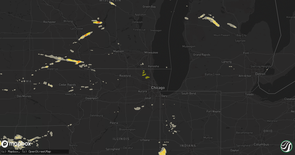
Hail Map on July 12, 2017
Get this storm
July 12 map
$229
one time, instant access
Download today. No call, no setup
Keep the $229
Bought the map and want the full workflow? Apply the entire $229 to a subscription within 7 days. None of it is wasted.
Every map, not just this one
This buys you this map. Subscription and you get every map we run, in the markets you choose from a few cities to whole states to nationwide. Plus real-time alerts the moment a storm fires.
Contact data
Name, contact info, occupancy, even credit band for addresses in the footprint. You go from where it hit to who to call.
Become the source they trust
Unlimited branding weather history reports on demand. You already have the documented answer ready for the property owner, and you are the one who showed up with it.
Property data and RoofTrace estimates
Pull up any address you have got, its value and the exact code rules for that jurisdiction, straight from One Click Code. Then RoofTrace estimates the squares, pitch, and roof value, priced the way you price.
States Impacted by Hail Map on July 12, 2017
Storm reports
Texas
| Date | Description |
|---|---|
| 07/12/20176:43 PM CDT | Epzwxnet site at txdot building. Mesowest id epz03. Max sustained wind 45 mph. |
Rhode Island
| Date | Description |
|---|---|
| 07/12/20172:45 PM CDT | Tree down on north main street |
| 07/12/20172:20 PM CDT | Tree down on bucklin street. |
Michigan
| Date | Description |
|---|---|
| 07/12/20174:53 PM CDT | Tree down on crystal lake road close to the wi state line. Source is law enforcement. Time is estimated from radar. |
| 07/12/20172:00 AM CDT | Road commission indicated numerous trees down over roads... Particularly in winterfield township. Also some road washouts. Time estimated by radar. |
| 07/12/20171:40 AM CDT | Power lines down at 20 mile rd and 50th ave. |
| 07/12/20171:34 AM CDT | Tree down at m115 and 100th ave. |
| 07/12/20171:30 AM CDT | County road commission indicated numerous trees down in the vicinity of 160th and 15 mile roads and also 230th and 16 mile. Also some road washouts. Time estimated by r |
| 07/12/20171:15 AM CDT | Report of tree damage relayed from emergency manager. Time estimated from radar. |
| 07/12/20171:15 AM CDT | Tree and power lines down at six mile rd and n coe rd. |
| 07/12/20171:10 AM CDT | County road commission indicated numerous large tree branches needed cleared from roads in the northern quarter of the county. Also several road washouts. Time estimate |
| 07/12/20171:01 AM CDT | Tree reported down in eden township. |
| 07/11/201711:54 PM CDT | Tree down over boon rd. At m-115. |
| 07/11/20178:35 PM CDT | Tree down. Source is menominee county central dispatch. Time is estimated from radar. |
| 07/11/20178:18 PM CDT | Delayed report. Numerous trees down...completely blocking the road. |
Iowa
| Date | Description |
|---|---|
| 07/12/20175:58 PM CDT | A tree was down on the golf course and other small limbs around town. |
| 07/12/20175:44 PM CDT | Nickel to quarter size. Not much of it. |
| 07/12/20179:48 AM CDT | Driveway also washed out from last night's rains. Cannot leave home. |
| 07/12/20179:27 AM CDT | A local report indicates 1.00 inch wind near VOLGA |
| 07/12/20179:20 AM CDT | A local report indicates 1.00 inch wind near VOLGA |
| 07/11/20178:52 PM CDT | A few trees were reported down in the city of clinton. |
| 07/11/20178:29 PM CDT | Clinton county roads department reported that a few trees had to be cleared from secondary roads around the dewitt area. |
| 07/11/20177:48 PM CDT | Measured high gust from local wind sensor. |
| 07/11/20177:47 PM CDT | Dot reported a couple of trees were down in stanwood. Time is based on radar. |
Connecticut
| Date | Description |
|---|---|
| 07/12/20173:04 PM CDT | Tree down on wires at route 97 and route 14 |
| 07/12/20173:03 PM CDT | Multiple trees and wires down |
| 07/12/20172:50 PM CDT | Tree limbs down |
| 07/12/201712:36 PM CDT | A local report indicates 1.00 inch wind near WINDSOR LOCKS |
| 07/12/201712:28 PM CDT | A local report indicates 1.00 inch wind near WINDSOR LOCKS |
| 07/12/201712:03 PM CDT | A local report indicates 1.00 inch wind near SUFFIELD |
| 07/12/201712:00 PM CDT | A local report indicates 1.00 inch wind near EAST GRANBY |
Nebraska
| Date | Description |
|---|---|
| 07/12/201710:11 AM CDT | A local report indicates 1.50 inch wind near 8 NE NORTH PLATTE |
Wisconsin
| Date | Description |
|---|---|
| 07/12/20176:18 PM CDT | 6 box elder trees down and ping-pong sized hail. Driveway blocked. |
| 07/12/20176:18 PM CDT | Tree down. |
| 07/12/20176:08 PM CDT | Roof damage to metal outbuilding. Relayed via broadcast media. Time estimated from radar. |
| 07/12/20174:53 PM CDT | Tree down on crystal lake road near wisconsin border. Source is gogebic/iron county dispatch. Time is estimated from radar. |
| 07/11/20177:38 PM CDT | Tree blown down onto a power line. |
| 07/11/20177:17 PM CDT | Size estimated from photo on social media. Relayed via broadcast media. Time estimated from radar. |
| 07/11/20177:10 PM CDT | Trees and powerlines down. Time estimated by radar. |
Indiana
| Date | Description |
|---|---|
| 07/12/20175:55 PM CDT | Thunderstorm winds blew down two three to four-inch diameter trees... A flag pole... And a section of wood fence. Accompanied by 2.50 inches of rain in about 30 minutes |
| 07/12/201712:43 AM CDT | Dispatch reported a tree down across the road on 1050 n. No information on size/health of the tree. |
Colorado
| Date | Description |
|---|---|
| 07/12/20175:32 PM CDT | Asos station aff... Us air force academy. |
| 07/12/20174:05 PM CDT | Limon municipal airport reported a gust of 62 mph |
| 07/12/20173:44 PM CDT | A local report indicates 65 MPH wind near 7 NW LIMON |
Maine
| Date | Description |
|---|---|
| 07/12/20172:50 PM CDT | Large trees down on power lines and across shaving hill road |
Wyoming
| Date | Description |
|---|---|
| 07/11/201710:30 PM CDT | Lots of lightning as well. |
| 07/11/201710:11 PM CDT | Very heavy rainfall as well. |
| 07/11/20179:02 PM CDT | Rochelle hills raws site |
South Dakota
| Date | Description |
|---|---|
| 07/11/201710:30 PM CDT | Lots of lightning as well. |
Missouri
| Date | Description |
|---|---|
| 07/11/20178:45 PM CDT | Tree was blown down on to a box trailer. Time estimated from radar. |
| 07/11/20178:03 PM CDT | Report and photo of tree broken. Received on fb. |
| 07/11/20178:01 PM CDT | Several trees knocked down in town. |
Massachusetts
| Date | Description |
|---|---|
| 07/12/20176:30 PM CDT | At 73 blake street... Wires down... Power meters ripped off houses... Tree blocking the road. |
| 07/12/20176:26 PM CDT | At lowell avenue and washington... Leaning pole due to excessive winds has resulted in lowered wires across the road leading to lowell avenue being closed. |
| 07/12/20176:14 PM CDT | At 69 lowell avenue... Arcing wires with tree branch down on wires. |
| 07/12/20176:06 PM CDT | Lexington street at warren blocked by trees |
| 07/12/20176:05 PM CDT | Tree down on beacon street |
| 07/12/20175:52 PM CDT | Washington road closed due to downed trees and wires |
| 07/12/20175:47 PM CDT | Tree down on car on anthony circle |
| 07/12/20175:46 PM CDT | Large branch down at arlington and heath street |
| 07/12/20175:45 PM CDT | Trees and wires down on pleasant street |
| 07/12/20175:44 PM CDT | Tree down on charles river street at irvine street |
| 07/12/20174:30 PM CDT | Two large trees down on lempicki road |
| 07/12/20173:17 PM CDT | Tree down on wires on prospect street |
| 07/12/20173:10 PM CDT | Multiple trees and wires down on county street |
| 07/12/20173:09 PM CDT | Tree and wires down on jeffrey lane at gramp deane road |
| 07/12/20173:08 PM CDT | Multiple trees down on main street |
| 07/12/20173:08 PM CDT | Tree down on river street |
| 07/12/20173:04 PM CDT | Tree down on wires on prospect street |
| 07/12/20173:00 PM CDT | Road closed due to trees on road |
| 07/12/20172:58 PM CDT | Tree down on wires on temple street |
| 07/12/20172:55 PM CDT | Tree down on cedar street... Tree and wires down on elm street... And tree down on bay state road |
| 07/12/20172:50 PM CDT | Trees down on route 44 |
| 07/12/20171:07 PM CDT | Tree down on wires on west street |
| 07/12/201712:40 PM CDT | Tree down on north westfield street |
| 07/12/201712:20 PM CDT | Power lines down on washington street |
| 07/12/201712:18 PM CDT | Trees down on arnold street |
| 07/12/201712:00 PM CDT | A local report indicates 1.25 inch wind near MILFORD |
| 07/12/201711:57 AM CDT | A local report indicates 1.00 inch wind near MILFORD |
| 07/12/201711:50 AM CDT | Tree down on car by route 140 gasco fuel |
| 07/12/201711:50 AM CDT | Multiple trees and wires down on fowler street |
| 07/12/201711:47 AM CDT | Tree down on merriam road |
| 07/12/201711:42 AM CDT | Tree down on warren street |
New York
| Date | Description |
|---|---|
| 07/12/20175:25 PM CDT | Tree down in roadway |
| 07/11/201711:25 PM CDT | Tree down across parker road in town of hadley |
| 07/11/201710:30 PM CDT | Two trees down on county route 24 |
| 07/11/201710:00 PM CDT | Trees down and barn blown across rd |
Illinois
| Date | Description |
|---|---|
| 07/12/20179:45 AM CDT | Twenty power line poles snapped out at base. Time estimated off of radar. |
| 07/12/20179:20 AM CDT | Branches down. |
Virginia
| Date | Description |
|---|---|
| 07/12/20173:20 PM CDT | Dime to quarter size hail fell. |
| 07/12/20173:20 PM CDT | Thunderstorm winds caused 3 to 6 inch diameter limbs to fall in a homeowners backyard. |
Pennsylvania
| Date | Description |
|---|---|
| 07/12/20174:42 PM CDT | Hail covering the ground...some quarter to half dollar sized. |
Cities Impacted by Hail Map on July 12, 2017
- Peshtigo, WI
- Pound, WI
- East Dubuque, IL
- Maxwell, NE
- Stapleton, NE
- North Platte, NE
- Remington, IN
- Goodland, IN
- Kingman, IN
- Veedersburg, IN
- Oconto, NE
- Denver, IA
- North Dighton, MA
- Rehoboth, MA
- Dighton, MA
- Swansea, MA
- Mecca, IN
- Universal, IN
- Terre Haute, IN
- New Goshen, IN
- West Terre Haute, IN
- Dennison, IL
- Hillsdale, IN
- Clinton, IN
- Dana, IN
- Montezuma, IN
- Rosedale, IN
- Paris, IL
- Rockville, IN
- Bloomingdale, IN
- Burlington, CO
- Gilman City, MO
- Trenton, MO
- Bethany, MO
- Spickard, MO
- Netawaka, KS
- Wetmore, KS
- Cadillac, MI
- Manter, KS
- Syracuse, KS
- Marion, MI
- Harrison, MI
- Lake, MI
- Evart, MI
- Farwell, MI
- McBain, MI
- Sumner, IA
- Westgate, IA
- Fairbank, IA
- Genoa, WI
- Viroqua, WI
- Cashton, WI
- De Soto, WI
- Westby, WI
- La Farge, WI
- Wausaukee, WI
- Stephenson, MI
- Leesville, LA
- Baileys Harbor, WI
- Colesburg, IA
- Garber, IA
- Guttenberg, IA
- Tustin, MI
- Lance Creek, WY
- Grafton, MA
- Hopedale, MA
- Milford, MA
- Northbridge, MA
- Upton, MA
- South Grafton, MA
- Toledo, IA
- Tama, IA
- Robinson, KS
- Boon, MI
- Powhattan, KS
- Burlington, WI
- Karval, CO
- Cedar Falls, IA
- New Hartford, IA
- New Lisbon, WI
- Warrens, WI
- Camp Douglas, WI
- Tomah, WI
- Necedah, WI
- Leaf River, IL
- Menominee, MI
- Francesville, IN
- Rensselaer, IN
- Monon, IN
- Sturgeon Bay, WI
- Egg Harbor, WI
- Fish Creek, WI
- Stratton, CO
- Lafayette, IN
- Sparland, IL
- Henry, IL
- New Providence, IA
- Hubbard, IA
- Iron River, MI
- Watersmeet, MI
- Conover, WI
- Eagle River, WI
- Marshall, IL
- Jamesport, MO
- Free Soil, MI
- Manistee, MI
- Mount Horeb, WI
- Verona, WI
- Stout, IA
- Parkersburg, IA
- Chelsea, IA
- Slagle, LA
- Goff, KS
- Corning, KS
- Nashville, IL
- Sheridan Lake, CO
- Tribune, KS
- Mount Carroll, IL
- Chadwick, IL
- Flagler, CO
- Seibert, CO
- Stevens Point, WI
- Junction City, WI
- Clarence, IA
- Kane, PA
- Phelps, WI
- Land O'Lakes, WI
- Troy, KS
- Everest, KS
- Highland, KS
- Hiawatha, KS
- Shell Rock, IA
- Browning, MO
- Milan, MO
- Sherrill, IA
- New Vienna, IA
- Holy Cross, IA
- Eads, CO
- Tiona, PA
- Ludlow, PA
- Wilcox, PA
- Sheffield, PA
- Clarendon, PA
- Warren, PA
- Gallatin, MO
- Cheyenne Wells, CO
- Idalia, CO
- Weskan, KS
- Arapahoe, CO
- Rockwell City, IA
- Chillicothe, MO
- Stockbridge, MI
- Fence, WI
- Armstrong Creek, WI
- Long Lake, WI
- Goodman, WI
- Dunbar, WI
- Florence, WI
- East Granby, CT
- Broad Brook, CT
- Windsor, CT
- East Windsor, CT
- Windsor Locks, CT
- Ellington, CT
- Animas, NM
- Helena, MO
- Union Star, MO
- Rea, MO
- Savannah, MO
- Wallace, KS
- Argonne, WI
- Mauston, WI
- Steamboat Rock, IA
- Kit Carson, CO
- Vernon, CO
- Edgar, WI
- Louisville, IL
- Ingraham, IL
- Dieterich, IL
- Newton, IL
- Noble, IL
- Rhodes, MI
- Nogales, AZ
- Bethune, CO
- Vona, CO
- Otterbein, IN
- West Lafayette, IN
- Elfrida, AZ
- Anacoco, LA
- Yale, IA
- Jamaica, IA
- Kirksville, MO
- Greentop, MO
- Novinger, MO
- Adel, GA
- Dickeyville, WI
- Dubuque, IA
- Cuba City, WI
- Potosi, WI
- Scribner, NE
- Cumberland, RI
- Manville, RI
- Albion, RI
- Lincoln, RI
- North Smithfield, RI
- Broken Bow, NE
- Clearwater Beach, FL
- Belleair Beach, FL
- Indian Rocks Beach, FL
- Arion, IA
- Dow City, IA
- Kirk, CO
- Perry, IA
- Baring, MO
- Downing, MO
- Memphis, MO
- Brashear, MO
- Leoti, KS
- Sharon Springs, KS
- State Center, IA
- Divide, CO
- Florissant, CO
- Delmar, IA
- Withee, WI
- Medford, WI
- Moosup, CT
- Sterling, CT
- Plainfield, CT
- Pawtucket, RI
- Seekonk, MA
- Mount Vernon, IA
- Lisbon, IA
- Bayard, IA
- Arlington, WI
- Hamilton, GA
- Oregon, MO
- Saint Petersburg, FL
- Spring, TX
- Waverly, IA
- Readlyn, IA
- Janesville, IA
- Waterloo, IA
- Oelwein, IA
- Millbury, MA
- Green Castle, MO
- Kirbyville, TX
- Tekamah, NE
- Craig, NE
- Brookston, IN
- Elkport, IA
- Edgewood, IA
- Arlington, IA
- Cassville, WI
- Volga, IA
- Strawberry Point, IA
- Wadena, IA
- Elkader, IA
- Greeley, IA
- Saint Amant, LA
- King City, MO
- Guilford, MO
- Bagley, IA
- Solon, IA
- Iowa City, IA
- North Liberty, IA
- Fayette, IA
- Elgin, IA
- Houston, TX
- Humble, TX
- Pattonsburg, MO
- Maynard, IA
- Randalia, IA
- Marshalltown, IA
- Augusta, WI
- Humphreys, MO
- Pinconning, MI
- Yuma, CO
- Joes, CO
- Luxemburg, IA
- Gardner, IL
- Ransom, IL
- Dwight, IL
- Verona, IL
- Mazon, IL
- Kinsman, IL
- Wellsburg, IA
- Darlington, MO
- Stanberry, MO
- Albany, MO
- Green City, MO
- Sayner, WI
- Boscobel, WI
- Muscoda, WI
- Little Sioux, IA
- Purdin, MO
- Linneus, MO
- Chula, MO
- Wrentham, MA
- Rio Verde, AZ
- Ames, IA
- Boone, IA
- Banks, AL
- Gilman, WI
- Rhodes, IA
- Baxter, IA
- Altamont, MO
- Lock Springs, MO
- Breckenridge, MO
- Hamilton, MO
- Mooresville, MO
- Slatersville, RI
- Harrisville, RI
- Bouton, IA
- Montour, IA
- Garwin, IA
- Ionia, IA
- Plainfield, IA
- Arriba, CO
- La Crosse, IN
- Irons, MI
- Wellston, MI
- Charlotte, IA
- Grand Mound, IA
- De Witt, IA
- Brady, NE
- Arnold, NE
- Amazonia, MO
- Leroy, MI
- Peotone, IL
- Wilmington, IL
- Upton, WY
- Laredo, MO
- Galt, MO
- Mason, MI
- Dansville, MI
- Owen, WI
- Scotland, CT
- Windham, CT
- Baltic, CT
- Canterbury, CT
- Hampton, CT
- Tierra Amarilla, NM
- Maquoketa, IA
- Greene, IA
- Marble Rock, IA
- Charles City, IA
- Altha, FL
- Blountstown, FL
- Tripoli, IA
- Hawkeye, IA
- Fredericksburg, IA
- Nashua, IA
- Frederika, IA
- Rumford, RI
- Bryant, IA
- Lewis Run, PA
- Winona, KS
- Hillsboro, IN
- Ridgeway, MO
- Coffey, MO
- Galax, VA
- Independence, VA
- Brookfield, MO
- Blue Mounds, WI
- Lansing, IA
- Franklin, MA
- Plainville, MA
- Somerset, MA
- Providence, RI
- Attleboro, MA
- Berkley, MA
- Assonet, MA
- Central Falls, RI
- Durango, IA
- Medway, MA
- Savanna, IL
- McFall, MO
- Jameson, MO
- Maysville, MO
- Cozad, NE
- Donnellson, IA
- Farmington, IA
- Luana, IA
- Postville, IA
- Monona, IA
- Wheeler, IL
- Lowell, IN
- Crown Point, IN
- Battle Ground, IN
- Wolcott, IN
- Chalmers, IN
- Ontario, WI
- Melbourne, IA
- West Point, IA
- Avon Park, FL
- Georgetown, IL
- Danville, IL
- Westville, IL
- Perrysville, IN
- Farmersburg, IN
- Queen City, MO
- Story City, IA
- Lowden, IA
- Fowler, IN
- Dighton, KS
- Fort Myers, FL
- Estero, FL
- Coal City, IL
- Braceville, IL
- Braidwood, IL
- Winigan, MO
- New Boston, MO
- Morland, KS
- Galena, IL
- Bolckow, MO
- Rosendale, MO
- Cosby, MO
- Granby, CT
- Waukon, IA
- Lost Nation, IA
- Wheatland, IA
- Athens, WI
- Stetsonville, WI
- Wallace, MI
- Porterfield, WI
- Ingalls, MI
- Lake Geneva, WI
- Miles, IA
- Rockford, IA
- Hope, MI
- Beaverton, MI
- Gladwin, MI
- Fort Hancock, TX
- Star Lake, WI
- Pembine, WI
- Buffalo, WY
- Kaycee, WY
- Gillette, WY
- Mchenry, IL
- Ringwood, IL
- Spring Grove, IL
- Crystal Lake, IL
- Wauconda, IL
- Ingleside, IL
- Island Lake, IL
- Round Lake, IL
- Mundelein, IL
- Lake Zurich, IL
- Barrington, IL
- Enfield, CT
- Suffield, CT
- Taunton, MA