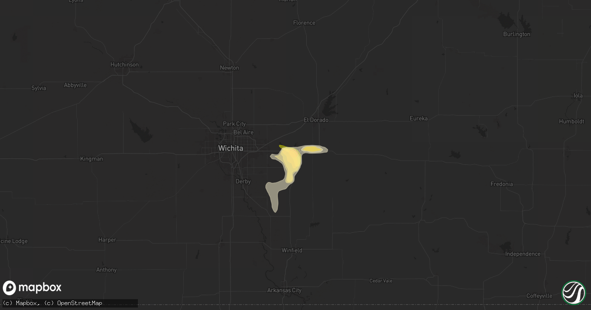
Hail Map in Augusta, KS on July 11, 2025
Get this storm
July 11 map
$229
one time, instant access
Download today. No call, no setup
Keep the $229
Bought the map and want the full workflow? Apply the entire $229 to a subscription within 7 days. None of it is wasted.
Every map, not just this one
This buys you this map. Subscription and you get every map we run, in the markets you choose from a few cities to whole states to nationwide. Plus real-time alerts the moment a storm fires.
Contact data
Name, contact info, occupancy, even credit band for addresses in the footprint. You go from where it hit to who to call.
Become the source they trust
Unlimited branding weather history reports on demand. You already have the documented answer ready for the property owner, and you are the one who showed up with it.
Property data and RoofTrace estimates
Pull up any address you have got, its value and the exact code rules for that jurisdiction, straight from One Click Code. Then RoofTrace estimates the squares, pitch, and roof value, priced the way you price.
Storm reports in Augusta, KS
Augusta, KS
| Date | Description |
|---|---|
| 07/11/20256:59 PM CDT | A local report indicates 1.00 inch wind near 1 WSW Augusta |
| 07/11/20256:55 PM CDT | Emergency manager reported quarter size hail at stanta fe lake. |
| 07/10/20257:20 PM CDT | A local report indicates 1.75 inch wind near 1 SW Augusta |
| 07/10/20257:20 PM CDT | Courtesy of kake. |
| 07/10/20257:11 PM CDT | A local report indicates 1.25 inch wind near 1 S Augusta |
All States Impacted by Hail Map on July 11, 2025
All Cities Impacted by Hail Map on July 11, 2025
- Cannon Ball, ND
- Linton, ND
- Walker, IA
- Center Point, IA
- Coggon, IA
- Winthrop, IA
- Breckenridge, MN
- Rothsay, MN
- Fergus Falls, MN
- Panora, IA
- Linden, IA
- Yale, IA
- Dawson, IA
- Perry, IA
- Ocala, FL
- Belleview, FL
- Bouton, IA
- Richville, MN
- Ottertail, MN
- Minburn, IA
- Woodward, IA
- Scottsboro, AL
- Menahga, MN
- Madrid, IA
- Park Rapids, MN
- Mauk, GA
- Knoxville, GA
- Lizella, GA
- Akeley, MN
- Walker, MN
- Dudley, GA
- Columbus, MS
- Crawford, MS
- Dexter, GA
- Hackensack, MN
- Cook, MN
- Naples, FL
- Saint Charles, IA
- Sebeka, MN
- Dublin, GA
- Angora, MN
- McRae Helena, GA
- Glenwood, MO
- Lancaster, MO
- Backus, MN
- South Bay, FL
- Belle Glade, FL
- Federal Dam, MN
- Orr, MN
- Side Lake, MN
- Toomsuba, MS
- Prole, IA
- Winterset, IA
- Norwalk, IA
- Immokalee, FL
- Estero, FL
- Fort Myers, FL
- Cochran, GA
- New Waverly, TX
- Downing, MO
- Lehigh Acres, FL
- Alva, FL
- Indianola, IA
- Remer, MN
- Labelle, FL
- Meridian, MS
- Huntsville, TX
- Trenton, MO
- Galt, MO
- Hawkinsville, GA
- Itta Bena, MS
- Schlater, MS
- Bloomfield, IA
- Alma, GA
- Mershon, GA
- Martensdale, IA
- Hibbing, MN
- Eastman, GA
- Nevis, MN
- Cohasset, MN
- Pillager, MN
- Bridgewater, IA
- Massena, IA
- Des Moines, IA
- Greenwood, MS
- Cumberland, IA
- Pulaski, IA
- Odum, GA
- Mitchellville, IA
- Brainerd, MN
- Deer River, MN
- Carlisle, IA
- Colfax, IA
- Felda, FL
- Milledgeville, GA
- Moore Haven, FL
- Clewiston, FL
- Prairie City, IA
- Runnells, IA
- Tama, IA
- Outing, MN
- Tarrytown, GA
- Soperton, GA
- Little Falls, MN
- Royalton, MN
- Grinnell, IA
- Fairfield, IA
- Milton, IA
- Nashwauk, MN
- Tupelo, MS
- Shannon, MS
- Cuba City, WI
- Platteville, WI
- Harris, MO
- Newtown, MO
- Monroe, IA
- Oakhurst, TX
- Newton, IA
- Cleveland, SC
- Cantril, IA
- Keosauqua, IA
- Sandersville, GA
- Aguilar, CO
- Pineview, GA
- Dubuque, IA
- Hazel Green, WI
- Belle Plaine, IA
- Otley, IA
- Collins, GA
- Cobbtown, GA
- Sidon, MS
- Vinton, IA
- Mount Auburn, IA
- Gatewood, MO
- Doniphan, MO
- Shaw, MS
- Cleveland, MS
- Kellogg, IA
- Rowley, IA
- Hartwick, IA
- Chelsea, IA
- Clearmont, MO
- Hopkins, MO
- Brighton, IA
- Urbana, IA
- Salem, AL
- Kieler, WI
- Belmont, WI
- Deerwood, MN
- Ironton, MN
- Jesup, GA
- Lynnville, IA
- Sully, IA
- Laramie, WY
- Brandon, IA
- Van Meter, IA
- Washington, IA
- Smiths Station, AL
- Potosi, WI
- Darlington, WI
- Mineral Point, WI
- Garrison, IA
- Shellsburg, IA
- Atkins, IA
- Van Horne, IA
- Newhall, IA
- Cedar Rapids, IA
- Watkins, IA
- Walford, IA
- Palo, IA
- Fairfax, IA
- Norway, IA
- Ely, IA
- Swisher, IA
- Mount Vernon, IA
- Lisbon, IA
- Hiawatha, IA
- Robins, IA
- Marion, IA
- Mechanicsville, IA
- Anamosa, IA
- Toddville, IA
- Alburnett, IA
- Springville, IA
- Martelle, IA
- Central City, IA
- Prairieburg, IA
- Ryan, IA
- Hopkinton, IA
- Morley, IA
- Monticello, IA
- Olin, IA
- Langworthy, IA
- Avon, MN
- Letts, IA
- Blairstown, IA
- Metter, GA
- Claxton, GA
- Searsboro, IA
- Emily, MN
- Crosby, MN
- Stockport, IA
- Masonville, IA
- Columbus Junction, IA
- Register, GA
- Shullsburg, WI
- Blanchardville, WI
- Wyoming, IA
- Center Junction, IA
- Worthington, IA
- Cascade, IA
- Farley, IA
- Delhi, IA
- Onslow, IA
- Monmouth, IA
- Maquoketa, IA
- Bernard, IA
- Baldwin, IA
- Epworth, IA
- Peosta, IA
- Argyle, WI
- Montezuma, IA
- Bigfork, MN
- Bovey, MN
- Pleasantville, IA
- West Liberty, IA
- West Branch, IA
- Conesville, IA
- Patterson, IA
- Earlville, IA
- Dyersville, IA
- New Vienna, IA
- Colesburg, IA
- Greeley, IA
- Swan River, MN
- Pella, IA
- Manchester, IA
- Edgewood, IA
- Oxford, MS
- Warba, MN
- Grand Rapids, MN
- Swan, IA
- Walsenburg, CO
- Pleasant Hill, IA
- Cumming, IA
- Garfield, GA
- Statesboro, GA
- Portal, GA
- New Sharon, IA
- Marengo, IA
- Quasqueton, IA
- Zwingle, IA
- Durango, IA
- La Motte, IA
- Sherrill, IA
- Buford, WY
- Rocky Ford, GA
- Kellerton, IA
- Chappell, NE
- Salem, IA
- Hillsboro, IA
- Mount Pleasant, IA
- Hamilton, IA
- Lovilia, IA
- Melrose, IA
- Bussey, IA
- Rutherfordton, NC
- Guttenberg, IA
- Luxemburg, IA
- Hollandale, WI
- New Glarus, WI
- Monticello, WI
- Andrew, IA
- Bellevue, IA
- East Dubuque, IL
- Spragueville, IA
- Atalissa, IA
- Tipton, IA
- Sylvania, GA
- Oshkosh, NE
- Jacksonville, FL
- Trinidad, CO
- Holy Cross, IA
- Lost Nation, IA
- Grand Mound, IA
- Calamus, IA
- Wheatland, IA
- Hendersonville, NC
- Marietta, SC
- Reasnor, IA
- Oskaloosa, IA
- Leighton, IA
- Muscatine, IA
- Independence, IA
- Saint Johns, FL
- Saint Augustine, FL
- Delmar, IA
- Tie Siding, WY
- Granite Canon, WY
- Cheyenne, WY
- Mount Horeb, WI
- Wilton, IA
- Moscow, IA
- Blue Grass, IA
- Durant, IA
- Stockton, IA
- Walcott, IA
- Davenport, IA
- Eldridge, IA
- Rock Island, IL
- Corydon, IA
- Braman, OK
- New London, IA
- Weston, CO
- North Buena Vista, IA
- Hephzibah, GA
- Knoxville, IA
- Jamaica, IA
- Newkirk, OK
- Dundee, IA
- Sigourney, IA
- Moline, IL
- Bettendorf, IA
- Galena, IL
- Hanover, IL
- Stockton, IL
- Elizabeth, IL
- Savanna, IL
- Benton, WI
- Scales Mound, IL
- Dickeyville, WI
- Apple River, IL
- South English, IA
- Harper, IA
- Webster, IA
- Roseville, IL
- Augusta, GA
- Hanna, WY
- Arkansas City, KS
- Wayland, IA
- Blockton, IA
- Yarmouth, IA
- Mount Union, IA
- Cassville, WI
- Chariton, IA
- Pueblo, CO
- Mountain Iron, MN
- Iron, MN
- Lavonia, GA
- East Prairie, MO
- Carthage, IL
- Kabetogama, MN
- Lockridge, IA
- Morning Sun, IA
- Greenwood, SC
- Medicine Bow, WY
- Weare, NH
- Francestown, NH
- Milan, IL
- Silvis, IL
- Hampton, IL
- Pleasant Valley, IA
- Carbon Cliff, IL
- East Moline, IL
- Le Claire, IA
- Colona, IL
- Port Byron, IL
- Rapids City, IL
- Hillsdale, IL
- Miles, IA
- Mount Carroll, IL
- Pearl City, IL
- Gratiot, WI
- Warren, IL
- Kent, IL
- Nora, IL
- Winslow, IL
- Lena, IL
- Monroe, WI
- Freeport, IL
- Browntown, WI
- McConnell, IL
- South Wayne, WI
- Dakota, IL
- Orangeville, IL
- Woodford, WI
- Lexington, SC
- Princeton, IA
- Maynard, AR
- Danville, IA
- West Point, IA
- Canon, GA
- Hartwell, GA
- Bowersville, GA
- Rock River, WY
- Vaughn, NM
- Earlham, IA
- Union Mills, NC
- Arcadia, FL
- Carr, CO
- Raton, NM
- Nunn, CO
- Coal Valley, IL
- Geneseo, IL
- Juda, WI
- Cedarville, IL
- Brodhead, WI
- Davis, IL
- Rock City, IL
- Albany, WI
- Orfordville, WI
- Cimarron, NM
- Maxwell, NM
- Las Vegas, NM
- Springer, NM
- Evans, GA
- Mediapolis, IA
- Weed, NM
- Bonaparte, IA
- Hodges, SC
- Donalds, SC
- Grover, CO
- Monmouth, IL
- Lakemont, GA
- Bosler, WY
- Arbela, MO
- Winfield, IA
- Russell, IA
- Millerton, IA
- Byers, CO
- Allerton, IA
- Durand, IL
- Rockton, IL
- Beloit, WI
- Evansville, WI
- Janesville, WI
- Footville, WI
- Brooklyn, WI
- Belleville, WI
- Edgerton, WI
- Springfield, CO
- Waverly, TN
- McEwen, TN
- Hurricane Mills, TN
- Ocate, NM
- Mount Sterling, IA
- Luray, MO
- Baskin, LA
- Plattsburg, MO
- Stewartsville, MO
- Donnellson, IA
- Farmington, IA
- Sperry, IA
- Burlington, IA
- Augusta, KS
- Andover, KS
- Fleming, CO
- Afton, IA
- Littlefork, MN
- Delhi, LA
- Epps, LA
- Cordova, IL
- Illinois City, IL
- Afton, WI
- Milton, WI
- Avalon, WI
- Whitewater, WI
- Fort Atkinson, WI
- Oakville, IA
- Wapello, IA
- Prophetstown, IL
- Tampico, IL
- Deer Grove, IL
- Rock Falls, IL
- Beulah, CO
- Harmon, IL
- Longmont, CO
- Boulder, CO
- Gray Court, SC
- Summerville, SC
- Abbeville, SC
- Due West, SC
- Memphis, MO
- Cameron, MO
- Guadalupita, NM
- Shannon City, IA
- Des Moines, NM
- Grenville, NM
- Niwot, CO
- Fort Morgan, CO
- Log Lane Village, CO
- Fowler, CO
- Model, CO
- Lafayette, CO
- Pattonsburg, MO
- Pierce, CO
- Gilman City, MO
- Spickard, MO
- Ware Shoals, SC
- New Boston, IL
- Keithsburg, IL
- Coffey, MO
- Briggsdale, CO
- Louisville, CO
- Erie, CO
- Las Animas, CO
- Dixon, IL
- Franklin Grove, IL
- Oregon, IL
- Chana, IL
- Ashton, IL
- Seaton, IL
- Oquawka, IL
- Elkhorn, WI
- Delavan, WI
- Eagle, WI
- Palmyra, WI
- Jefferson, WI
- Helenville, WI
- Sullivan, WI
- Dousman, WI
- Oconomowoc, WI
- Westcliffe, CO
- Lanark, IL
- Milledgeville, IL
- Venus, FL
- Kahoka, MO
- Deland, FL
- Wood River, IL
- Edwardsville, IL
- Bethalto, IL
- Laurens, SC
- Rose Hill, KS
- Tiger, GA
- Wetmore, CO
- Delafield, WI
- Nashotah, WI
- La Junta, CO
- Lake Helen, FL
- Helena, OK
- Julesburg, CO
- Haxtun, CO
- Otis, CO
- Yuma, CO
- Arnett, OK
- Boone, CO
- Waterloo, SC
- Avondale, CO
- Ault, CO
- Calhoun Falls, SC
- Excelsior Springs, MO
- Rayville, MO
- Lawson, MO
- Higgins, TX
- Sedgwick, CO
- Wellington, CO
- Leon, KS
- Blackville, SC
- Polo, MO
- Pritchett, CO
- Belle Plaine, KS
- New Raymer, CO
- Stoneham, CO
- Fe Warren Afb, WY
- Goltry, OK
- Mineral Bluff, GA
- Douglass, KS
- Garnett, KS
- Princeton, MO
- Richland, IA
- Kearney, MO
- Kim, CO
- Merino, CO
- Oak Grove, MO
- Grain Valley, MO
- Lone Jack, MO
- Wray, CO
- Bates City, MO
- Odessa, MO
- Murray, IA
- Joy, IL
- Neeses, SC
- Norway, SC
- Independence, MO
- Milan, MO
- Coatsville, MO
- Grand River, IA
- Smithfield, IL
- Humphreys, MO
- Dix, NE
- Ottawa, KS
- Melvern, KS
- Wayland, MO
- Lees Summit, MO
- Kansas City, MO
- Fountain Inn, SC
- Carpenter, WY
- Galeton, CO
- Paola, KS
- Osawatomie, KS
- McCormick, SC
- Denmark, SC
- Argyle, IA
- Peru, IA
- Truro, IA
- Laredo, MO
- Greenwood, MO
- Lamoni, IA
- Lorimor, IA
- Thayer, IA
- Ward, CO
- Udall, KS
- Blue Springs, MO
- Buckner, MO
- Mer Rouge, LA
- Deming, NM
- Toronto, KS
- Chillicothe, MO
- Chula, MO
- Walnut, IL
- Conway Springs, KS
- Wyaconda, MO
- Rutledge, MO
- Bamberg, SC
- Cope, SC
- Anniston, AL
- Abingdon, IL
- Avon, IL
- Berwick, IL
- Wheeling, MO
- Folsom, NM
- Holt, MO
- Trementina, NM
- Wagon Mound, NM
- Lewellen, NE
- Arthur, NE
- Iola, KS
- La Harpe, KS
- Moran, KS
- Bronson, KS
- Redfield, KS
- Fort Scott, KS
- Uniontown, KS
- Rush, CO
- Ramah, CO
- Hugo, CO
- Vega, TX
- Limon, CO
- Matheson, CO
- Table Grove, IL
- Ipava, IL
- Wyoming, IL
- Eaton, CO
- Gentry, MO
- Williamsburg, KS
- Genoa, CO
- Wellsville, KS
- Clint, TX
- Fabens, TX
- San Elizario, TX
- El Paso, TX
- Tornillo, TX
- Sugar City, CO
- Farmerville, LA
- Johnston, SC
- Sondheimer, LA
- Lyons, CO
- Speer, IL
- Edelstein, IL
- Eckley, CO
- Bradford, IL
- Putnam, IL
- Piedmont, KS
- Gridley, KS
- Burlington, KS
- Jamestown, SC
- Waverly, KS
- Fort Madison, IA
- Winnsboro, LA
- Howard, KS
- Orchard, CO
- Mosquero, NM
- Logan, NM
- Nara Visa, NM
- Conchas Dam, NM
- Weldona, CO
- Wiggins, CO
- Le Roy, KS
- Kingsville, MO
- Pleasant Hill, MO
- Gorin, MO
- Baring, MO
- Sparland, IL
- Sterrett, AL
- Harpersville, AL
- Westphalia, KS
- Westminster, SC
- Wellington, KS
- Ordway, CO
- Sunray, TX
- Fall River, KS
- Longton, KS
- Fredonia, KS
- Arlington, CO
- Woodrow, CO
- Clearwater, NE
- Elgin, NE
- Richmond, KS
- Lane, KS
- Milton, KS
- Yates Center, KS
- Solano, NM
- Tiskilwa, IL
- Montrose, IA
- Henry, IL
- Eureka, KS
- Kersey, CO
- Otterville, MO
- Florence, MO
- Smithton, MO
- Sedalia, MO
- Tilden, NE
- Virgil, KS
- Paw Paw, IL
- Plainview, NE
- Cameron, IL
- Raritan, IL
- Albany, MO
- Broomfield, CO
- Brunswick, NE
- Ellston, IA
- Webb, IA
- Dalhart, TX
- Stratford, TX
- San Jon, NM
- Bard, NM
- Tucumcari, NM
- Eads, CO
- Haswell, CO
- Severy, KS
- Potter, NE
- Media, IL
- Colony, KS
- Neosho Falls, KS
- Greeley, KS
- Neal, KS
- Galesburg, IL
- Welda, KS
- Karval, CO
- Syracuse, MO
- Tipton, MO
- Fortuna, MO
- Sheldon, MO
- Lamar, MO
- Jerico Springs, MO
- Dumas, TX
- Fontana, KS
- Taylor Ridge, IL
- Harrisonburg, VA
- Gilson, IL
- Centerville, KS
- Parker, KS
- Saint Augustine, IL
- Cross, SC
- La Harpe, IL
- Knoxville, IL
- Wiley, CO
- Golden City, MO
- Arcola, MO
- Lockwood, MO
- Palisade, MN
- Dahlonega, GA
- Aitkin, MN
- Broadwater, NE
- Rock, KS
- Piqua, KS
- Greenfield, MO
- Bunceton, MO
- Hartley, TX
- Channing, TX
- Kincaid, KS
- Dayton, VA
- Baldwin City, KS
- Union Springs, AL
- Mount Olive, IL
- Benld, IL
- Lakefield, MN
- Spirit Lake, IA
- La Plata, MO
- Grady, NM
- Broadview, NM
- Mcalister, NM
- Amarillo, TX
- Snyder, CO
- Buffalo, KS
- Benedict, KS
- Chanute, KS
- Humboldt, KS
- Ohatchee, AL
- Oxford Junction, IA
- Amistad, NM
- Alpha, MN
- Masterson, TX
- Everton, MO
- Burlington, OK
- Elsmore, KS
- Sierra Blanca, TX
- Humeston, IA
- Hereford, TX
- Adrian, TX
- Texico, NM
- Friona, TX
- Clovis, NM
- Melrose, NM
- Altoona, KS
- Boise City, OK
- Saint Joseph, MO
- La Belle, MO
- Sibley, IL
- Leon, IA
- Derby, IA
- Edina, MO
- Keyes, OK
- Knox City, MO
- Novelty, MO
- Keokuk, IA
- Elk Falls, KS
- Grand Blanc, MI
- Bayard, NE
- Hurdland, MO
- Daytona Beach, FL
- Panhandle, TX
- Moro, IL
- Nauvoo, IL
- Elk City, KS
- Holly, CO
- Stinnett, TX
- Bridgeport, NE
- Mountville, SC
- Claude, TX
- Macy, NE
- Long Grove, IA
- Donahue, IA
- De Witt, IA
- Smithshire, IL
- Ashby, NE
- Olney Springs, CO
- Crowley, CO
- East Alton, IL
- Alton, IL
- Lemoyne, NE
- Deltona, FL
- Tryon, NE
- Sutherland, NE
- Alva, OK
- Osteen, FL
- Saint Louis, MO
- Atkinson, IL
- Annawan, IL
- Texhoma, OK
- Paxton, NE
- Wayside, TX
- Groom, TX
- Hartington, NE
- Canyon, TX
- McClave, CO
- Princeville, IL
- Queen City, MO
- Laurel Hill, FL
- Elgin, IL
- Iliff, CO
- Sterling, CO
- Pollock, MO
- Newkirk, NM
- Hillrose, CO
- Sheridan Lake, CO
- Damascus, GA
- Sloan, IA
- Bogue, KS
- Winnebago, NE
- Hubbard, NE
- Homer, NE
- Perryville, MO
- East Troy, WI
- Syracuse, KS
- Meadville, MO
- Cuervo, NM
- Jackson, MN
- Dawn, MO
- Garita, NM
- Roxana, IL
- Minneola, KS
- Sedan, NM
- Laverne, OK
- Milford, IA
- Estherville, IA
- Dunnell, MN
- Dodge City, KS
- Johnson, KS
- Sawyerville, IL
- Linneus, MO
- Paullina, IA
- Ford, KS
- Ulysses, KS
- Lakin, KS
- Atlanta, MO
- Satanta, KS
- Palisade, NE
- Wauneta, NE
- Forgan, OK
- Fritch, TX
- Spearville, KS
- Bucklin, KS
- Gate, OK
- Vershire, VT
- Rosston, OK
- Floyd, NM
- Elida, NM
- Goodwell, OK
- Buffalo, OK
- Tulsa, OK
- Loganton, PA
- Dimmitt, TX
- Cimarron, KS
- Ensign, KS


