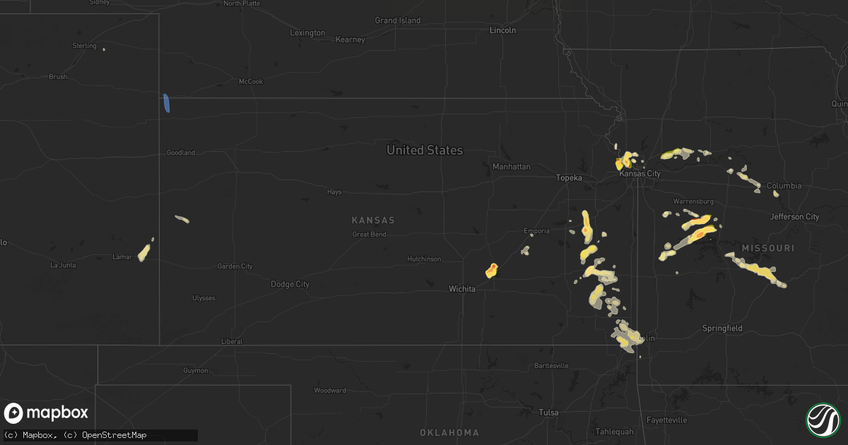
Hail Map in Kansas on July 11, 2024
Get this storm
July 11 map
$229
one time, instant access
Download today. No call, no setup
Keep the $229
Bought the map and want the full workflow? Apply the entire $229 to a subscription within 7 days. None of it is wasted.
Every map, not just this one
This buys you this map. Subscription and you get every map we run, in the markets you choose from a few cities to whole states to nationwide. Plus real-time alerts the moment a storm fires.
Contact data
Name, contact info, occupancy, even credit band for addresses in the footprint. You go from where it hit to who to call.
Become the source they trust
Unlimited branding weather history reports on demand. You already have the documented answer ready for the property owner, and you are the one who showed up with it.
Property data and RoofTrace estimates
Pull up any address you have got, its value and the exact code rules for that jurisdiction, straight from One Click Code. Then RoofTrace estimates the squares, pitch, and roof value, priced the way you price.
Storm reports in Kansas
Kansas
| Date | Description |
|---|---|
| 07/11/20246:57 PM CDT | A local report indicates 2.00 inch wind near 8 N El Dorado |
| 07/11/20243:25 AM CDT | Trees down in the road. Time estimated from radar. |
| 07/11/202412:45 AM CDT | A local report indicates 1.50 inch wind near 2 N Gas |
| 07/11/202412:24 AM CDT | Report from mping: quarter |
| 07/10/202411:17 PM CDT | A local report indicates 1.75 inch wind near 1 SSE Lansing |
| 07/10/202411:10 PM CDT | A local report indicates 1.75 inch wind near Lansing |
| 07/10/202411:00 PM CDT | Social media photo of measured quarter size hail near intersection of hollingsworth rd and k-7. |
| 07/10/202410:54 PM CDT | A local report indicates 1.75 inch wind near 1 SSE Lansing |
| 07/10/202410:49 PM CDT | A local report indicates 1.50 inch wind near 2 S Lansing |
| 07/10/202410:42 PM CDT | Ping pong ball size hail near the lansing intermediate school reported on social media. Time estimated from radar. |
| 07/10/202410:30 PM CDT | Large tree blocking entire roadway.... |
| 07/10/202410:25 PM CDT | A local report indicates 1.75 inch wind near 1 ENE Lansing |
| 07/10/202410:15 PM CDT | A local report indicates 1.00 inch wind near 2 NNW Lansing |
| 07/10/20247:45 PM CDT | A local report indicates 1.25 inch wind near 3 WSW El Dorado |
| 07/10/20247:29 PM CDT | Time estimated via radar. |
| 07/10/20247:00 PM CDT | A local report indicates 2.00 inch wind near 8 S Burns |
All States Impacted by Hail Map on July 11, 2024
Cities Impacted by Hail Map on July 11, 2024
- San Carlos, AZ
- Prescott, AZ
- Cheyenne, OK
- Sayre, OK
- Plaquemine, LA
- Addis, LA
- Willcox, AZ
- Mayer, AZ
- Raton, NM
- Crown King, AZ
- Perryville, MO
- Tribune, KS
- El Dorado Springs, MO
- Lebo, KS
- Belle Fourche, SD
- Kearny, AZ
- Fredericktown, MO
- Saint Onge, SD
- Marquand, MO
- Waverly, KS
- Rich Hill, MO
- Vail, AZ
- Spearfish, SD
- Rockville, MO
- Schell City, MO
- Shobonier, IL
- Vandalia, IL
- Whitewood, SD
- El Dorado, KS
- Appleton City, MO
- Butler, MO
- Tucson, AZ
- Burns, KS
- Tamaroa, IL
- Scheller, IL
- Waltonville, IL
- Sheridan Lake, CO
- Sesser, IL
- Holly, CO
- Emporia, KS
- Montrose, MO
- Olpe, KS
- Osceola, MO
- Clinton, MO
- Deepwater, MO
- Towanda, KS
- Granada, CO
- Blairstown, MO
- Urich, MO
- Ludlow, SD
- Chilhowee, MO
- Leeton, MO
- Rinard, IL
- Oshkosh, NE
- Sells, AZ
- Madison, KS
- Matfield Green, KS
- Lakeside, NE
- Calhoun, MO
- Windsor, MO
- Ellsworth, NE
- Kansas City, MO
- Ionia, MO
- Lincoln, MO
- Warsaw, MO
- Bowman, ND
- Green Ridge, MO
- Waldron, MO
- Fleming, CO
- Lewellen, NE
- Platte City, MO
- Arthur, NE
- Roundup, MT
- Kansas City, KS
- Two Dot, MT
- Hobson, MT
- Buffalo, MT
- Judith Gap, MT
- Lewistown, MT
- Leavenworth, KS
- Lemoyne, NE
- Lansing, KS
- Garden City, MO
- Melville, MT
- Basehor, KS
- Valentine, NE
- Excelsior Springs, MO
- Liberty, MO
- Farley, MO
- Orrick, MO
- Rayville, MO
- Richmond, MO
- Holden, MO
- Galesburg, KS
- Warrensburg, MO
- Erie, KS
- Haigler, NE
- Saint Francis, KS
- Centerview, MO
- Fort Leavenworth, KS
- Chanute, KS
- Saint Paul, KS
- Hardin, MO
- Yates Center, KS
- Walnut, KS
- Hepler, KS
- Norborne, MO
- Dover, MO
- Colony, KS
- Iola, KS
- Girard, KS
- Carrollton, MO
- McCune, KS
- Neosho Falls, KS
- Parsons, KS
- La Harpe, KS
- Humboldt, KS
- Moran, KS
- Melvern, KS
- Weston, MO
- Elsmore, KS
- Uniontown, KS
- Bronson, KS
- Westphalia, KS
- Le Roy, KS
- Welda, KS
- Columbus, KS
- Kincaid, KS
- Garnett, KS
- Miami, MO
- Stark, KS
- Savonburg, KS
- Marshall, MO
- Slater, MO
- Richmond, KS
- Scammon, KS
- Quapaw, OK
- Miami, OK
- Baxter Springs, KS
- Treece, KS
- Picher, OK
- Greeley, KS
- Lane, KS
- Williamsburg, KS
- Gilliam, MO
- Princeton, KS
- Gorham, IL
- Jacob, IL
- Ava, IL
- Blackwater, MO
- Nelson, MO
- Arrow Rock, MO
- Murphysboro, IL
- Merriman, NE
- Mission, SD
- Pomona, KS
- Galena, KS
- Franklin, MO
- Carbondale, IL
- Pomona, IL
- Riverton, KS
- Boonville, MO
- Joplin, MO
- Carl Junction, MO
- Ottawa, KS
- New Franklin, MO
- Winner, SD
- Redfield, KS
- Wooldridge, MO
- Jamestown, MO
- Prairie Home, MO
- Colome, SD
- West Mineral, KS
- Springview, NE
- Cherokee, KS
- Edwards, MO
- Ashland, MO
- Hartsburg, MO
- Haxtun, CO
- Weir, KS
- Gregory, SD
- Macks Creek, MO
- Cross Timbers, MO
- Burke, SD
- Climax Springs, MO
- Camdenton, MO
- Herrick, SD
- Chetopa, KS
- Roach, MO
- Stoutland, MO
- Richland, MO
- Johnstown, NE
- Lebanon, MO
- Eldridge, MO
- Linn Creek, MO
- Gann Valley, SD
- Ainsworth, NE
- Montreal, MO
- Wessington Springs, SD
- Kimball, SD
- Seneca, MO
- Laquey, MO
- Long Pine, NE
- Fort Scott, KS


