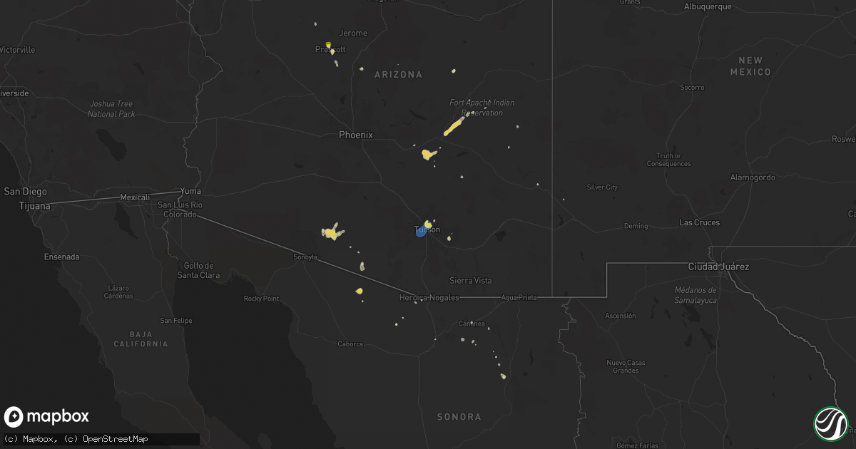
Hail Map on July 11, 2024
Get this storm
July 11 map
$229
one time, instant access
Download today. No call, no setup
Keep the $229
Bought the map and want the full workflow? Apply the entire $229 to a subscription within 7 days. None of it is wasted.
Every map, not just this one
This buys you this map. Subscription and you get every map we run, in the markets you choose from a few cities to whole states to nationwide. Plus real-time alerts the moment a storm fires.
Contact data
Name, contact info, occupancy, even credit band for addresses in the footprint. You go from where it hit to who to call.
Become the source they trust
Unlimited branding weather history reports on demand. You already have the documented answer ready for the property owner, and you are the one who showed up with it.
Property data and RoofTrace estimates
Pull up any address you have got, its value and the exact code rules for that jurisdiction, straight from One Click Code. Then RoofTrace estimates the squares, pitch, and roof value, priced the way you price.
States Impacted by Hail Map on July 11, 2024
Storm reports
Arizona
| Date | Description |
|---|---|
| 07/11/20246:27 PM CDT | Severe weather in the area has damaged equipment causing power outages to roughly 120 people. |
| 07/11/20246:03 PM CDT | Mesonet station azt16 san simon. |
| 07/11/20245:53 PM CDT | Mesonet station azt15 bowie. |
| 07/11/20245:50 PM CDT | Mesonet station azt19 i-10 @ mp-372.3 - olga. |
| 07/11/20244:50 PM CDT | A local report indicates 1.00 inch wind near 4 SW Prescott Airport |
| 07/10/20249:00 PM CDT | Large tree downed at courthouse in peach springs. Time estimated. |
| 07/10/20248:23 PM CDT | A peak wind gust of 77 mph was measured by the kingman airport asos. Radar and lightning data indicated a thunderstorm close to the airport at the time. |
| 07/10/20247:40 PM CDT | Power poles reported down west of i-10 between tangerine and avra valley rd. |
| 07/10/20247:35 PM CDT | 3 inch branches down near swan rd. And san fransisco rd. |
| 07/10/20247:35 PM CDT | Mesonet station dw4959 tucson star pass rd. |
| 07/10/20247:30 PM CDT | Large tree uprooted. Time estimated from radar. |
| 07/10/20247:30 PM CDT | Damage to roof tiles and broken light fixture. |
| 07/10/20247:20 PM CDT | Estimate of 1 inch hail. |
| 07/10/20247:15 PM CDT | Mesonet station ke77 san manuel airport. |
Nebraska
| Date | Description |
|---|---|
| 07/10/202411:43 PM CDT | A local report indicates 58 MPH wind near 1 ENE Haigler |
Maine
| Date | Description |
|---|---|
| 07/11/20245:13 PM CDT | Tree down on mudgett road in corinth. |
| 07/11/20244:28 PM CDT | Tree down along tobey rd. |
Montana
| Date | Description |
|---|---|
| 07/10/20249:40 PM CDT | Awos station k1lm judith gap. |
Michigan
| Date | Description |
|---|---|
| 07/10/20247:15 PM CDT | Photo of large tree down in yard near 44th st and eastern ave. Time estimated by radar. |
New Mexico
| Date | Description |
|---|---|
| 07/11/20246:35 PM CDT | Mesonet station nm008 lordsburg playa i10 mp7 |
Illinois
| Date | Description |
|---|---|
| 07/11/20246:58 PM CDT | Several trees and power lines down in sesser with one tree falling onto a car. |
| 07/10/20249:22 PM CDT | Report from mping: trees uprooted or snapped. |
| 07/10/20247:22 PM CDT | Tree down on pickle city rd. |
| 07/10/20247:14 PM CDT | Trees and power lines down with power pole damage at n madison st in benton. |
| 07/10/20247:14 PM CDT | Trees and power lines down with power pole damage at n madison st in benton. |
| 07/10/20247:14 PM CDT | Power lines and trees down on e bond st between n mcleansboro st and 9th st. |
Kansas
| Date | Description |
|---|---|
| 07/11/20246:57 PM CDT | A local report indicates 2.00 inch wind near 8 N El Dorado |
| 07/11/20243:25 AM CDT | Trees down in the road. Time estimated from radar. |
| 07/11/202412:45 AM CDT | A local report indicates 1.50 inch wind near 2 N Gas |
| 07/11/202412:24 AM CDT | Report from mping: quarter |
| 07/10/202411:17 PM CDT | A local report indicates 1.75 inch wind near 1 SSE Lansing |
| 07/10/202411:10 PM CDT | A local report indicates 1.75 inch wind near Lansing |
| 07/10/202411:00 PM CDT | Social media photo of measured quarter size hail near intersection of hollingsworth rd and k-7. |
| 07/10/202410:54 PM CDT | A local report indicates 1.75 inch wind near 1 SSE Lansing |
| 07/10/202410:49 PM CDT | A local report indicates 1.50 inch wind near 2 S Lansing |
| 07/10/202410:42 PM CDT | Ping pong ball size hail near the lansing intermediate school reported on social media. Time estimated from radar. |
| 07/10/202410:30 PM CDT | Large tree blocking entire roadway.... |
| 07/10/202410:25 PM CDT | A local report indicates 1.75 inch wind near 1 ENE Lansing |
| 07/10/202410:15 PM CDT | A local report indicates 1.00 inch wind near 2 NNW Lansing |
| 07/10/20247:45 PM CDT | A local report indicates 1.25 inch wind near 3 WSW El Dorado |
| 07/10/20247:29 PM CDT | Time estimated via radar. |
| 07/10/20247:00 PM CDT | A local report indicates 2.00 inch wind near 8 S Burns |
Missouri
| Date | Description |
|---|---|
| 07/11/20246:37 PM CDT | A local report indicates 1.00 inch wind near 5 E Rich Hill |
| 07/11/20246:37 PM CDT | Medium sized tree branches down. |
| 07/11/202412:43 AM CDT | Social media report and video of hail up to quarter size south of carrollton. Time estimated from radar. |
| 07/11/202412:42 AM CDT | Social media report of quarter size hail in carrollton with photos. Time estimated from radar. |
| 07/10/202411:12 PM CDT | A local report indicates 1.00 inch wind near 2 S Woods Heights |
| 07/10/202411:12 PM CDT | Quarter size hail reported at sundance ranch south of wood heights. |
| 07/10/202410:02 PM CDT | A local report indicates 1.75 inch wind near 2 E Waldron |
| 07/10/202410:02 PM CDT | A local report indicates 1.50 inch wind near 1 W Parkville |
| 07/10/20249:58 PM CDT | Social media report and photo of half dollar size hail in parkville. Time estimated from radar. |
| 07/10/20249:52 PM CDT | Social media... Sent in a photo of ping pong size hail alongside screenshot of location. |
| 07/10/20249:49 PM CDT | Report from mping: quarter |
| 07/10/20249:34 PM CDT | A local report indicates 1.00 inch wind near 2 S Ferrelview |
| 07/10/20249:15 PM CDT | A local report indicates 1.50 inch wind near 5 NW Palo Pinto |
| 07/10/20249:03 PM CDT | A local report indicates 1.25 inch wind near 1 W Windsor |
| 07/10/20249:00 PM CDT | A local report indicates 2.25 inch wind near 4 WNW Windsor |
| 07/10/20248:12 PM CDT | A local report indicates 1.25 inch wind near 5 ENE Hartwell |
| 07/10/20248:08 PM CDT | A local report indicates 1.25 inch wind near 3 E Clinton |
| 07/10/20248:08 PM CDT | A local report indicates 2.25 inch wind near 5 SSW Calhoun |
| 07/10/20248:01 PM CDT | Quarter sized hail lasting for 10 min. |
South Dakota
| Date | Description |
|---|---|
| 07/11/20246:10 PM CDT | A local report indicates 60 MPH wind near Saint Onge |
| 07/11/20246:09 PM CDT | A local report indicates 65 MPH wind near 3 NW Saint Onge |
| 07/10/20248:19 PM CDT | A local report indicates 1.25 inch wind near 3 NW Ludlow |
Colorado
| Date | Description |
|---|---|
| 07/10/20248:33 PM CDT | Asos station kdro durango la plata cnty airport. |
Cities Impacted by Hail Map on July 11, 2024
- San Carlos, AZ
- Prescott, AZ
- Cheyenne, OK
- Sayre, OK
- Plaquemine, LA
- Addis, LA
- Willcox, AZ
- Mayer, AZ
- Raton, NM
- Crown King, AZ
- Perryville, MO
- Tribune, KS
- El Dorado Springs, MO
- Lebo, KS
- Belle Fourche, SD
- Kearny, AZ
- Fredericktown, MO
- Saint Onge, SD
- Marquand, MO
- Waverly, KS
- Rich Hill, MO
- Vail, AZ
- Spearfish, SD
- Rockville, MO
- Schell City, MO
- Shobonier, IL
- Vandalia, IL
- Whitewood, SD
- El Dorado, KS
- Appleton City, MO
- Butler, MO
- Tucson, AZ
- Burns, KS
- Tamaroa, IL
- Scheller, IL
- Waltonville, IL
- Sheridan Lake, CO
- Sesser, IL
- Holly, CO
- Emporia, KS
- Montrose, MO
- Olpe, KS
- Osceola, MO
- Clinton, MO
- Deepwater, MO
- Towanda, KS
- Granada, CO
- Blairstown, MO
- Urich, MO
- Ludlow, SD
- Chilhowee, MO
- Leeton, MO
- Rinard, IL
- Oshkosh, NE
- Sells, AZ
- Madison, KS
- Matfield Green, KS
- Lakeside, NE
- Calhoun, MO
- Windsor, MO
- Ellsworth, NE
- Kansas City, MO
- Ionia, MO
- Lincoln, MO
- Warsaw, MO
- Bowman, ND
- Green Ridge, MO
- Waldron, MO
- Fleming, CO
- Lewellen, NE
- Platte City, MO
- Arthur, NE
- Roundup, MT
- Kansas City, KS
- Two Dot, MT
- Hobson, MT
- Buffalo, MT
- Judith Gap, MT
- Lewistown, MT
- Leavenworth, KS
- Lemoyne, NE
- Lansing, KS
- Garden City, MO
- Melville, MT
- Basehor, KS
- Valentine, NE
- Excelsior Springs, MO
- Liberty, MO
- Farley, MO
- Orrick, MO
- Rayville, MO
- Richmond, MO
- Holden, MO
- Galesburg, KS
- Warrensburg, MO
- Erie, KS
- Haigler, NE
- Saint Francis, KS
- Centerview, MO
- Fort Leavenworth, KS
- Chanute, KS
- Saint Paul, KS
- Hardin, MO
- Yates Center, KS
- Walnut, KS
- Hepler, KS
- Norborne, MO
- Dover, MO
- Colony, KS
- Iola, KS
- Girard, KS
- Carrollton, MO
- McCune, KS
- Neosho Falls, KS
- Parsons, KS
- La Harpe, KS
- Humboldt, KS
- Moran, KS
- Melvern, KS
- Weston, MO
- Elsmore, KS
- Uniontown, KS
- Bronson, KS
- Westphalia, KS
- Le Roy, KS
- Welda, KS
- Columbus, KS
- Kincaid, KS
- Garnett, KS
- Miami, MO
- Stark, KS
- Savonburg, KS
- Marshall, MO
- Slater, MO
- Richmond, KS
- Scammon, KS
- Quapaw, OK
- Miami, OK
- Baxter Springs, KS
- Treece, KS
- Picher, OK
- Greeley, KS
- Lane, KS
- Williamsburg, KS
- Gilliam, MO
- Princeton, KS
- Gorham, IL
- Jacob, IL
- Ava, IL
- Blackwater, MO
- Nelson, MO
- Arrow Rock, MO
- Murphysboro, IL
- Merriman, NE
- Mission, SD
- Pomona, KS
- Galena, KS
- Franklin, MO
- Carbondale, IL
- Pomona, IL
- Riverton, KS
- Boonville, MO
- Joplin, MO
- Carl Junction, MO
- Ottawa, KS
- New Franklin, MO
- Winner, SD
- Redfield, KS
- Wooldridge, MO
- Jamestown, MO
- Prairie Home, MO
- Colome, SD
- West Mineral, KS
- Springview, NE
- Cherokee, KS
- Edwards, MO
- Ashland, MO
- Hartsburg, MO
- Haxtun, CO
- Weir, KS
- Gregory, SD
- Macks Creek, MO
- Cross Timbers, MO
- Burke, SD
- Climax Springs, MO
- Camdenton, MO
- Herrick, SD
- Chetopa, KS
- Roach, MO
- Stoutland, MO
- Richland, MO
- Johnstown, NE
- Lebanon, MO
- Eldridge, MO
- Linn Creek, MO
- Gann Valley, SD
- Ainsworth, NE
- Montreal, MO
- Wessington Springs, SD
- Kimball, SD
- Seneca, MO
- Laquey, MO
- Long Pine, NE
- Fort Scott, KS