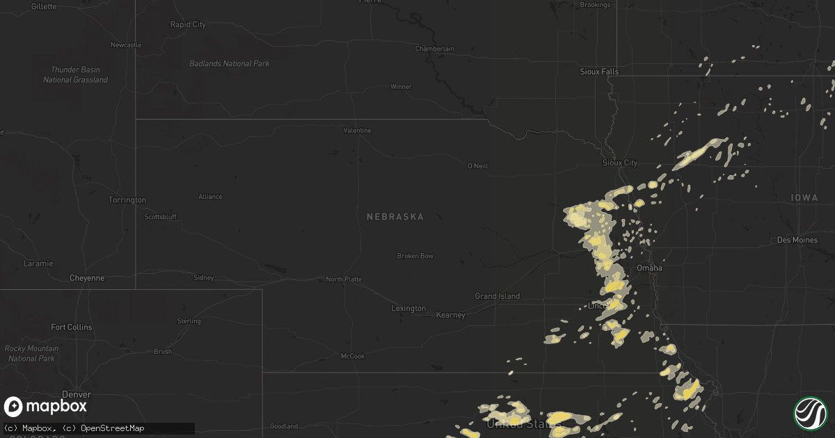
Hail Map in Nebraska on July 11, 2016
Get this storm
July 11 map
$229
one time, instant access
Download today. No call, no setup
Keep the $229
Bought the map and want the full workflow? Apply the entire $229 to a subscription within 7 days. None of it is wasted.
Every map, not just this one
This buys you this map. Subscription and you get every map we run, in the markets you choose from a few cities to whole states to nationwide. Plus real-time alerts the moment a storm fires.
Contact data
Name, contact info, occupancy, even credit band for addresses in the footprint. You go from where it hit to who to call.
Become the source they trust
Unlimited branding weather history reports on demand. You already have the documented answer ready for the property owner, and you are the one who showed up with it.
Property data and RoofTrace estimates
Pull up any address you have got, its value and the exact code rules for that jurisdiction, straight from One Click Code. Then RoofTrace estimates the squares, pitch, and roof value, priced the way you price.
Storm reports in Nebraska
Nebraska
| Date | Description |
|---|---|
| 07/10/201610:05 PM CDT | Pea to one inch sized hail and 1.4 inches of rain. Has seven rain gauges. Delayed report. |
| 07/10/20168:47 PM CDT | A local report indicates 58 MPH wind near 3 ESE TEKAMAH |
| 07/10/20168:32 PM CDT | A local report indicates 1.00 inch wind near SUPERIOR |
| 07/10/20167:45 PM CDT | Several large ash trees downed with winds estimated 60+. Gusty winds lasted until 9pm. Delayed report. |
| 07/10/20167:43 PM CDT | A local report indicates 60 MPH wind near LYONS |
| 07/10/20167:33 PM CDT | Also nickel size hail. |
| 07/10/20167:30 PM CDT | Trees and power lines blown down. |
| 07/10/20167:25 PM CDT | Power lines blown down. |
| 07/10/20167:10 PM CDT | A local report indicates 60 MPH wind near 5 ENE WISNER |
| 07/10/20167:00 PM CDT | A local report indicates 1.00 inch wind near PENDER |
All States Impacted by Hail Map on July 11, 2016
Cities Impacted by Hail Map on July 11, 2016
- Jackson, LA
- Goldsmith, TX
- Marquette, KS
- Chase, KS
- Geneseo, KS
- Lyons, KS
- Little River, KS
- Kermit, TX
- Rozel, KS
- Nekoma, KS
- Greenwood, NE
- Alvo, NE
- Askov, MN
- Beeler, KS
- Cimarron, KS
- Ness City, KS
- Morrill, KS
- Holyoke, MN
- Foxboro, WI
- Great Bend, KS
- Collins, MS
- Seminary, MS
- Laurens, IA
- Newell, IA
- Albert City, IA
- Sterling, KS
- Britton, SD
- Eudora, AR
- Oto, IA
- Mapleton, IA
- Smithland, IA
- Gorham, KS
- Atchison, KS
- Stanton, NE
- Clarkson, NE
- Palmer, IA
- Pomeroy, IA
- Chester, SC
- Carlisle, SC
- Branford, FL
- Bell, FL
- White Cloud, KS
- Robinson, KS
- Sandstone, MN
- Isle, MN
- Wilson, KS
- Claflin, KS
- Holyrood, KS
- Fitzpatrick, AL
- Ramer, AL
- Troy, AL
- Union Springs, AL
- Grady, AL
- Walton, KS
- Newton, KS
- West Point, NE
- Rush Center, KS
- Moline, KS
- Cedar Vale, KS
- Clyde, KS
- Morganville, KS
- Clifton, KS
- Solomon, KS
- Pequot Lakes, MN
- Melrose, FL
- Paradise, KS
- Russell, KS
- Waldo, KS
- Verdon, NE
- Salem, NE
- Cheyenne Wells, CO
- Cable, WI
- Underwood, IA
- Glenwood, MN
- Cottonwood, MN
- Ghent, MN
- Marshall, MN
- Greer, SC
- Greenville, SC
- Travelers Rest, SC
- Taylors, SC
- Winnebago, MN
- Callahan, FL
- Fairmont, NC
- Rowland, NC
- Jarreau, LA
- Ventress, LA
- Melrose, MN
- Freeport, MN
- Albany, MN
- Cushing, WI
- Grantsburg, WI
- Augusta, WI
- Osseo, WI
- Lake City, SD
- Marion, KS
- Victoria, KS
- Danbury, IA
- Utica, KS
- Hays, KS
- Concord, NC
- Kannapolis, NC
- Elbow Lake, MN
- Beemer, NE
- Gibson, LA
- Wakeeney, KS
- Howells, NE
- Dodge, NE
- Pilger, NE
- Glynn, LA
- Rougon, LA
- McBee, SC
- Bennet, NE
- Adams, NE
- Hickman, NE
- Douglas, NE
- Panama, NE
- Firth, NE
- Sauk Centre, MN
- Robbins, NC
- Eagle Springs, NC
- Schaller, IA
- Storm Lake, IA
- Lake Nebagamon, WI
- Pierre Part, LA
- Napoleonville, LA
- Mcpherson, KS
- Galva, KS
- Milaca, MN
- Henning, MN
- Ottertail, MN
- Ogallah, KS
- Ellis, KS
- Hector, MN
- Buffalo Lake, MN
- Wendell, MN
- Ipswich, SD
- Harris, MN
- Stanchfield, MN
- Saint Joseph, MO
- Whiting, IA
- Sloan, IA
- Southern Pines, NC
- Cameron, NC
- Fort Bragg, NC
- Vass, NC
- Wilber, NE
- De Witt, NE
- Missouri Valley, IA
- Leigh, NE
- Wisner, NE
- Parkers Prairie, MN
- Alexandria, LA
- Lakota, IA
- Tampa, KS
- Lincolnville, KS
- Durham, KS
- Monticello, MN
- Buffalo, MN
- Merrill, WI
- Onamia, MN
- Ogilvie, MN
- Brook Park, MN
- Mora, MN
- Colon, NE
- Wahoo, NE
- Bruno, MN
- Cambridge, MN
- Rush City, MN
- Manhattan, KS
- Beloit, KS
- Fall River, KS
- Howard, KS
- Severy, KS
- Piedmont, KS
- Deer Creek, MN
- Hewitt, MN
- Wadena, MN
- Lakefield, MN
- Jackson, MN
- Haswell, CO
- Las Animas, CO
- Rulo, NE
- Falls City, NE
- Limon, CO
- Hugo, CO
- Kit Carson, CO
- Flasher, ND
- Mandan, ND
- Rice, MN
- Laurel Hill, NC
- Bennettsville, SC
- Hamlet, NC
- Ethel, LA
- Crosby, MN
- Merrifield, MN
- Peabody, KS
- Tampa, FL
- Saxon, WI
- Hurley, WI
- Ironwood, MI
- Elkton, FL
- Ida Grove, IA
- Attapulgus, GA
- Downs, KS
- Foley, MN
- Hillman, MN
- Hinckley, MN
- Battle Creek, IA
- Correctionville, IA
- Chapman, KS
- Wakefield, KS
- Abilene, KS
- Dawson, MN
- Kiln, MS
- Webster, WI
- Siren, WI
- Atwater, MN
- New London, MN
- Paynesville, MN
- Glenham, SD
- Eagle Butte, SD
- Marcus, IA
- Sterling, NE
- Filley, NE
- Tecumseh, NE
- Martell, NE
- Cortland, NE
- Crab Orchard, NE
- Burr, NE
- Nisswa, MN
- Mason, WI
- Scribner, NE
- Pickens, SC
- Peterson, IA
- Sacred Heart, MN
- Belview, MN
- Renville, MN
- Canby, MN
- Randolph, KS
- Green, KS
- Leonardville, KS
- North Newton, KS
- Sartell, MN
- Saint Joseph, MN
- Douglass, KS
- Augusta, KS
- Leon, KS
- Avon, MN
- Cold Spring, MN
- Sabetha, KS
- Belle Rose, LA
- White Castle, LA
- Yutan, NE
- Springfield, NE
- Elmwood, NE
- Fremont, NE
- Pender, NE
- Oakland, NE
- Roca, NE
- Davey, NE
- Ceresco, NE
- North Bend, NE
- Eagle, NE
- Rosalie, NE
- Morse Bluff, NE
- Valley, NE
- Lyons, NE
- Gretna, NE
- Murdock, NE
- Malmo, NE
- Walton, NE
- Schuyler, NE
- Memphis, NE
- Snyder, NE
- Bancroft, NE
- Prague, NE
- Waterloo, NE
- Walthill, NE
- South Bend, NE
- Lincoln, NE
- Raymond, NE
- Unadilla, NE
- Cedar Bluffs, NE
- Ithaca, NE
- Weston, NE
- Mead, NE
- Palmyra, NE
- Rogers, NE
- Ames, NE
- Winnebago, NE
- Waverly, NE
- Hooper, NE
- Macy, NE
- Ashland, NE
- Plainville, KS
- Staples, MN
- Bertha, MN
- Browerville, MN
- Abbeville, AL
- Gypsum, KS
- Onaga, KS
- Rosalia, KS
- Eureka, KS
- El Dorado, KS
- Tekamah, NE
- Andover, KS
- Wichita, KS
- Decatur, NE
- Sheldon, WI
- Hawkins, WI
- Pleasant Dale, NE
- Mankato, KS
- Superior, NE
- Charlotte, NC
- Aitkin, MN
- Geneva, NE
- Bruning, NE
- Strang, NE
- Tobias, NE
- Milligan, NE
- Ohiowa, NE
- Hayward, WI
- Deerwood, MN
- Ironton, MN
- Brainerd, MN
- Harrisburg, NC
- Cedar Point, KS
- Florence, KS
- Wagram, NC
- Solon Springs, WI
- Sylvan Grove, KS
- Lincoln, KS
- Modale, IA
- Battle Lake, MN
- Dalton, MN
- Ashby, MN
- Gowrie, IA
- Montgomery, AL
- Shorter, AL
- Pike Road, AL
- Algona, IA
- Ogema, WI
- Westboro, WI
- Walker, KS
- Hosmer, SD
- Harvey, ND
- Roslyn, SD
- Hoisington, KS
- Motley, MN
- Pillager, MN
- Hornick, IA
- Amherst, SD
- Boston, GA
- Clay Center, KS
- Miltonvale, KS
- Winfield, KS
- Salina, KS
- Tescott, KS
- Carpenter, IA
- Grafton, IA
- Kensett, IA
- Northwood, IA
- Saint Ansgar, IA
- Saint Stephen, MN
- Richmond, MN
- Saint Cloud, MN
- Sauk Rapids, MN
- Royalton, MN
- Auburn, IA
- Lake City, IA
- Salem, AL
- Halstead, KS
- Sedgwick, KS
- Clio, SC
- Conway, SC
- Myrtle Beach, SC
- Arlington, NE
- Baton Rouge, LA
- Conover, NC
- Hiawatha, KS
- Natoma, KS
- Luray, KS
- Osborne, KS
- Cairo, GA
- Kershaw, SC
- Sedan, KS
- Brock, NE
- Galva, IA
- Marston, NC
- Bonifay, FL
- Falun, KS
- Lindsborg, KS
- Latham, KS
- Minneapolis, KS
- Beverly, KS
- Barnard, KS
- Cassatt, SC
- Annandale, MN
- Howard Lake, MN
- Waverly, MN
- Maple Lake, MN
- Big Lake, MN
- Dexter, KS
- Burden, KS
- Atlanta, KS
- Longton, KS
- Cambridge, KS
- Hamilton, KS
- Grenola, KS
- Elk Falls, KS
- Canton, KS
- Jamestown, KS
- Randall, KS
- Jewell, KS
- Alsen, ND
- Oak Grove, LA
- Pioneer, LA
- Hope Hull, AL
- McCracken, KS
- Olivia, MN
- Redwood Falls, MN
- Riley, KS
- Manly, IA
- Richland, GA
- Fair Bluff, NC
- Denison, KS
- Valley Falls, KS
- Aberdeen, SD
- Westport, SD
- Spencer, IA
- Concordia, KS
- Aurora, KS
- Horton, KS
- Onawa, IA
- Rose Hill, KS
- Wesley, IA
- Seneca, KS
- Drummond, WI
- Bendena, KS
- Lancaster, KS
- Ruskin, NE
- Holton, KS
- Glen Elder, KS
- Milford, NE
- Dorrance, KS
- Newton, NC
- Oak Vale, MS
- Raeford, NC
- Spooner, WI
- Trego, WI
- Kennan, WI
- Catawba, WI
- Vermillion, KS
- Frankfort, KS
- Timmonsville, SC
- Lamar, SC
- Darlington, SC
- Hartsville, SC
- Hickory, NC
- Raymond, KS
- Alden, KS
- Lake Providence, LA
- Rock, KS
- Glasco, KS
- Simpson, KS
- Goshen, AL
- Kiron, IA
- Alta, IA
- Lehigh, KS
- Hillsboro, KS
- Ashland, WI
- Montreal, WI
- Bessemer, MI
- Gile, WI
- Iron Belt, WI
- Holcombe, WI
- Thorp, WI
- Cleveland, ND
- Cawker City, KS
- Everest, KS
- Denton, KS
- Greenville, AL
- New Cambria, KS
- Bennington, KS
- McIntosh, SD
- Dothan, AL
- Nemaha, NE
- Fairfax, MO
- Shubert, NE
- Rock Port, MO
- Lumberton, NC
- Swanville, MN
- Opelika, AL
- Litchfield, MN
- Grove City, MN
- Kanopolis, KS
- Ellsworth, KS
- Lorraine, KS
- Hartley, IA
- Shelbyville, MO
- Emden, MO
- Westmoreland, KS
- Liberty, SC
- Clinton, NC
- Saint Michael, MN
- Manson, IA
- Manitowish Waters, WI
- Yulee, FL
- Matthews, NC
- Belgrade, MN
- Cherokee, IA
- Fenton, IA
- Cylinder, IA
- Lumpkin, GA
- Evergreen, NC
- Orrum, NC
- Little Falls, MN
- Meriden, IA
- Citra, FL
- Rockford, IA
- Mason City, IA
- Dillon, SC
- Lake View, SC
- Hamer, SC
- Hawthorne, FL
- Bird Island, MN
- Ute, IA
- Soldier, IA
- Junction City, KS
- Cleghorn, IA
- Paullina, IA
- Siler City, NC
- Bear Creek, NC
- Pittsboro, NC
- Slocomb, AL
- Craig, MO
- Wetmore, KS
- Circleville, KS
- Netawaka, KS
- Norcross, MN
- Pine City, MN
- Nickerson, NE
- Fairmont, MN
- Sturgeon Lake, MN
- Mcgregor, MN
- Hatley, WI
- Rosholt, WI
- Custer, WI
- Clear Lake, IA
- Ventura, IA
- Orlando, FL
- Herman, NE
- Kerrick, MN
- Pierz, MN
- Superior, WI
- Wrenshall, MN
- Barnum, MN
- Oak Park, MN
- Foreston, MN
- Troy, KS
- Forest City, MO
- Highland, KS
- Bowlus, MN
- Flensburg, MN
- Leola, SD
- McGrath, MN
- Madison, MN
- Fort Riley, KS
- Rockwell City, IA
- Hallam, NE
- Pocahontas, IA
- Havelock, IA
- Jacksons Gap, AL
- Emmetsburg, IA
- Winchester, KS
- Westside, IA
- Eland, WI
- Claire City, SD
- Veblen, SD
- Lidgerwood, ND
- Effingham, KS
- Osakis, MN
- Johnson, NE
- Waite Park, MN
- Rockville, MN
- Lynd, MN
- Castana, IA
- Brooksville, FL
- Dade City, FL
- Sheffield, IA
- Braham, MN
- North Branch, MN
- Isanti, MN
- Swanton, NE
- Folkston, GA
- Goessel, KS
- Highland Home, AL
- Clearwater, KS
- Nebraska City, NE
- Dunbar, NE
- Marengo, WI
- Cheraw, SC
- Rodney, IA
- Fairchild, WI
- Preston, MN
- Holstein, IA
- Wittenberg, WI
- Eureka, SD
- Morven, NC
- Crystal River, FL
- Blue Rapids, KS
- Scarville, IA
- Verndale, MN
- Wallace, SC
- Kettle River, MN
- Garner, IA
- Forest City, IA
- Fertile, IA
- Beverly Hills, FL
- Blair, SC
- Britt, IA
- Catharine, KS
- Lucas, KS
- Bunker Hill, KS
- Holdingford, MN
- Charles City, IA
- Alta Vista, IA
- Philadelphia, MO
- Garrison, MN
- Seven Springs, NC
- Bunnell, FL
- Wimbledon, ND
- Cooperstown, ND
- Maxton, NC
- Labelle, FL
- Moundridge, KS
- Hesston, KS
- Mass City, MI
- Mondamin, IA
- Uriah, AL
- Eads, CO
- Belvue, KS
- La Belle, MO
- Anoka, MN
- Elk River, MN
- Zimmerman, MN
- Plant City, FL
- Lakeland, FL
- High Bridge, WI
- Mellen, WI
- Echo, MN
- Blair, NE
- Withee, WI
- Lublin, WI
- Stanley, WI
- Little Rock, SC
- Bancroft, IA
- Zirconia, NC
- Whitewater, KS
- Burns, KS
- Morgan City, LA
- Bushton, KS
- Effingham, SC
- Coward, SC
- Esbon, KS
- Medford, WI
- Glen Flora, WI
- Gilman, WI
- Mcconnell Afb, KS
- Auburn, NE
- Rugby, ND
- Lake City, FL
- Bessemer City, NC
- Whiting, KS
- Frisco City, AL
- Bryceville, FL
- Glenville, MN
- Austin, MN
- Long Prairie, MN
- Sutherland, IA
- Clarkton, NC
- Wesley Chapel, FL
- Garland, NC
- Roseboro, NC
- Centralia, KS
- Nelson, NE
- Ionia, IA
- Hampden, ND
- Western, NE
- Logan, IA
- Elma, IA
- Otoe, NE
- Sumrall, MS
- Bassfield, MS
- Aurelia, IA
- Colfax, ND
- White Springs, FL
- Elmo, MO
- New Brockton, AL
- Brooten, MN
- Louisville, NE
- Autryville, NC
- Fonda, IA
- Arnold, KS
- Kingsland, GA
- Saint Marys, GA
- Weeping Water, NE
- Lake View, IA
- Bennington, NE
- Gordon, WI
- Zachary, LA
- Clopton, AL
- Newville, AL
- Jolley, IA
- Clear Lake, MN
- Becker, MN
- Riverview, FL
- Brandon, FL
- Bloomer, WI
- Lyle, MN
- Kimball, MN
- South Haven, MN
- Craig, NE
- Baxter, MN
- Woodstock, MN
- Crete, NE
- Lillington, NC
- Oregon, MO
- Maitland, MO
- Plymouth, IA
- Friend, NE
- Greenville, MS
- Cerro Gordo, NC
- Chadbourn, NC
- Donaldsonville, LA
- Avoca, NE
- Manilla, IA
- Ellinwood, KS
- Bladenboro, NC
- Whiteville, NC
- Princeton, MN
- La Junta, CO
- Chancellor, AL
- Portis, KS
- Fairfax, MN
- Watkins, MN
- Milford, KS
- Tallahassee, FL
- Rockwell, IA
- Ozark, AL
- Saint Augustine, FL
- Matfield Green, KS
- Ayrshire, IA
- Ruthven, IA
- Carson, MS
- Dover, FL
- Seffner, FL
- Morton, MN
- Rockwell, NC
- Landrum, SC
- Notasulga, AL
- Ewing, MO
- Hilliard, FL
- Cadott, WI
- Wheaton, MN
- Laurinburg, NC
- Aldrich, MN
- Remsen, IA
- Vining, MN
- Underwood, MN
- Clitherall, MN
- Havana, FL
- Mount Croghan, SC
- Jefferson, SC
- Ruby, SC
- Pageland, SC
- Welcome, MN
- Stacy, MN
- Wyoming, MN
- Albertson, NC
- Longford, KS
- Milroy, MN
- Osceola, WI
- Marietta, MN
- Burgaw, NC
- Hager City, WI
- Ellsworth, WI
- Prentiss, MS
- Graceville, FL
- Goff, KS
- Centreville, MS
- Syracuse, NE
- Towanda, KS
- Gilmore City, IA
- Bradgate, IA
- Galivants Ferry, SC
- Farnhamville, IA
- Somers, IA
- Riegelwood, NC
- Kennard, NE
- Primghar, IA
- Saint Francisville, LA
- Moorland, IA
- Humboldt, IA
- Webster, SD
- Oskaloosa, KS
- Nortonville, KS
- Iron River, WI
- Fountain City, WI
- Peru, NE
- Brantwood, WI
- Enterprise, AL
- Daleville, AL
- Rushville, MO
- Union, SC
- Minnewaukan, ND
- Devils Lake, ND
- Thonotosassa, FL
- Villard, MN
- Jakin, GA
- Blakely, GA
- Flora, MS
- Bentonia, MS
- Canton, MS
- Truman, MN
- Patrick, SC
- Olsburg, KS
- Perdido, AL
- Titonka, IA
- Martin, ND
- Sedalia, KY
- Brownville, NE
- Florence, SC
- Atmore, AL
- Cook, NE
- Grasston, MN
- Cornell, WI
- Hurdsfield, ND
- Floral City, FL
- Bushnell, FL
- Alton, KS
- Benton, KS
- Valley Center, KS
- Mount Hope, KS
- Burrton, KS
- Enterprise, KS
- Pawhuska, OK
- Fort Calhoun, NE
- Claremont, NC
- Woodstock, GA
- Marietta, GA
- Wahkon, MN


