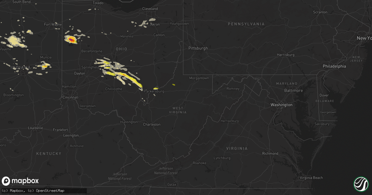
Hail Map in West Virginia on July 10, 2017
Get this storm
July 10 map
$229
one time, instant access
Download today. No call, no setup
Keep the $229
Bought the map and want the full workflow? Apply the entire $229 to a subscription within 7 days. None of it is wasted.
Every map, not just this one
This buys you this map. Subscription and you get every map we run, in the markets you choose from a few cities to whole states to nationwide. Plus real-time alerts the moment a storm fires.
Contact data
Name, contact info, occupancy, even credit band for addresses in the footprint. You go from where it hit to who to call.
Become the source they trust
Unlimited branding weather history reports on demand. You already have the documented answer ready for the property owner, and you are the one who showed up with it.
Property data and RoofTrace estimates
Pull up any address you have got, its value and the exact code rules for that jurisdiction, straight from One Click Code. Then RoofTrace estimates the squares, pitch, and roof value, priced the way you price.
Storm reports in West Virginia
West Virginia
| Date | Description |
|---|---|
| 07/10/20176:35 PM CDT | Topped pine tree |
| 07/10/20176:19 PM CDT | Tree and lines down along corbin branch road. Via social media... Time estimated from radar. |
| 07/10/20176:18 PM CDT | Multiple trees uprooted along matson run road between shinnston and pine bluff. Report via social media... Time estimated by radar. |
| 07/10/20176:14 PM CDT | Trees and wires down on highland road in ellenboro... Time estimated by radar |
| 07/10/20176:07 PM CDT | Large chestnut tree blown down. Time estimated by radar. |
| 07/10/20176:04 PM CDT | Multiple trees down in reynoldsville... One fell onto a car. Time estimated by radar. |
| 07/10/20176:03 PM CDT | Tree down in miletus. Time estimated by radar. |
| 07/10/20175:50 PM CDT | Trees down in parkersburg... Some power outages. Time estimated by radar. |
| 07/10/20175:47 PM CDT | Several trees down along route 23 west of center point. Via social media... Time estimated from radar. |
| 07/10/20175:45 PM CDT | Scattered trees and limbs down and power outages. |
| 07/10/20175:45 PM CDT | 100 ft oak tree splintered and twisted with numerous other trees down across hillsides. |
| 07/10/20175:45 PM CDT | Large tree and lines down along rock run road. Via social media... Time estimated from radar. |
| 07/10/20175:40 PM CDT | Multiple reports... Multiple trees snapped or uprooted with pictures via facebook. Time estimated via radar. |
| 07/10/20175:40 PM CDT | Social media post that pennsboro fire dept responded to trees and wires down on burton run road and off rt 74n mountain rd |
| 07/10/20175:37 PM CDT | Large tree down along route 18 near tyler/doddridge county line. Via social media... Time estimated from radar. |
| 07/10/20175:37 PM CDT | Multiple large hardwood trees down with pictures via facebook. Time estimated via radar. |
| 07/09/201710:53 PM CDT | Multiple trees uprooted along matson run road between shinnston and pine bluff. Report via social media... Time estimated by radar. |
| 07/09/201710:47 PM CDT | Tree limbs down in the road in jackson's mill. Reported via social media... Time estimated by radar. |
| 07/09/201710:35 PM CDT | Trees down in parkersburg... Some power outages. Time estimated by radar. |
| 07/09/20177:02 PM CDT | Tree down that had to be cleared by highway department across nancy run. Time estimated by radar |
All States Impacted by Hail Map on July 10, 2017
Cities Impacted by Hail Map on July 10, 2017
- Plain City, OH
- Milford Center, OH
- Mechanicsburg, OH
- West Jefferson, OH
- Galloway, OH
- Columbus, OH
- London, OH
- Grove City, OH
- Irwin, OH
- Hilliard, OH
- Woodstock, OH
- Garrison, MT
- Camp Crook, SD
- La Salle, IL
- Utica, IL
- Peru, IL
- North Port, FL
- Elgin, NE
- Twin Bridges, MT
- Wesley Chapel, FL
- Medina, OH
- Wadsworth, OH
- Zolfo Springs, FL
- Arcadia, FL
- Ewing, NE
- Bartlett, NE
- Petersburg, NE
- Ericson, NE
- Spalding, NE
- Anselmo, NE
- Nye, MT
- McLeod, MT
- Cassatt, SC
- Montpelier, ID
- Shannon, NC
- Lumber Bridge, NC
- Donnellson, IA
- West Point, IA
- Saint Paul, IA
- Livingston, MT
- New Castle, IN
- Middletown, IN
- Twelve Mile, IN
- Macy, IN
- Denver, IN
- Peru, IN
- Albany, MO
- Anaconda, MT
- Unionville, MO
- Ridgeway, MO
- Martinsville, MO
- Venedocia, OH
- Rockford, OH
- Celina, OH
- Mendon, OH
- Saint Marys, OH
- Spencerville, OH
- Cairo, GA
- Greycliff, MT
- Fort Wayne, IN
- New Haven, IN
- Silver Star, MT
- Amanda, OH
- Stoutsville, OH
- Circleville, OH
- Gold Creek, MT
- Greenfield, IN
- Fortville, IN
- Bradenton, FL
- Kahoka, MO
- Farmington, IA
- Dillon, MT
- Glen, MT
- Conrad, MT
- Bringhurst, IN
- Delphi, IN
- Riverton, IL
- Sherman, IL
- Grassy Butte, ND
- Ute, IA
- Dow City, IA
- Onawa, IA
- Soldier, IA
- Charter Oak, IA
- Denison, IA
- Hoskins, NE
- Stanton, NE
- Tilden, NE
- Oakdale, NE
- Wayne, NE
- Winside, NE
- Meadow Grove, NE
- Battle Creek, NE
- Norfolk, NE
- Pilger, NE
- Wisner, NE
- Centerpoint, IN
- Cory, IN
- Terre Haute, IN
- Brazil, IN
- Elmwood, IL
- Glasford, IL
- Hanna City, IL
- Trivoli, IL
- Mapleton, IL
- Peoria, IL
- Spring Valley, IL
- Dalzell, IL
- Lancaster, OH
- Hartsburg, IL
- Emden, IL
- Atlanta, IL
- Lincoln, IL
- Ohio City, OH
- Wapakoneta, OH
- Divide, MT
- Whitehall, MT
- Lambert, MT
- Akron, OH
- Vienna, WV
- Parkersburg, WV
- Williamstown, WV
- Upper Sandusky, OH
- Buffalo, SD
- Tippecanoe, IN
- Bourbon, IN
- Argos, IN
- Dade City, FL
- Daleville, IN
- Peninsula, OH
- Richfield, OH
- Pekin, IL
- Gosport, IN
- Bloomington, IN
- Eagleville, MO
- Indianapolis, IN
- Brownsburg, IN
- West Point, NE
- Bancroft, NE
- Beemer, NE
- Ovid, CO
- Burwell, NE
- Edinburg, IL
- Tovey, IL
- Bulpitt, IL
- Rochester, IL
- Taylorville, IL
- Kincaid, IL
- Pawnee, IL
- Morrisonville, IL
- Douds, IA
- Keosauqua, IA
- Birmingham, IA
- Sula, MT
- Philipsburg, MT
- Howells, NE
- Dodge, NE
- Bonaparte, IA
- Hinsdale, MT
- Lewistown, IL
- Ipava, IL
- Grace, ID
- Stonington, IL
- Blue Mound, IL
- Mount Sterling, OH
- Ashville, OH
- Orient, OH
- Arlington, IL
- Cherry, IL
- Carmel, IN
- Arnegard, ND
- Audubon, IA
- Pendleton, IN
- Wilkinson, IN
- Markleville, IN
- Grover Hill, OH
- Haviland, OH
- Brookston, IN
- Battle Ground, IN
- Palatka, FL
- Snellville, GA
- Pataskala, OH
- Reynoldsburg, OH
- Blacklick, OH
- Logansport, IN
- Jacksonville, FL
- Denver, MO
- Grinnell, IA
- Searsboro, IA
- Fort Madison, IA
- Niota, IL
- Keokuk, IA
- Argyle, IA
- Montrose, IA
- Hamilton, IL
- Nauvoo, IL
- Avon, MT
- Hall, MT
- Galata, MT
- Easton, IL
- Havana, IL
- Greenview, IL
- Athens, IL
- Petersburg, IL
- Kilbourne, IL
- Williamsville, IL
- Mason City, IL
- Elkhart, IL
- Whitlash, MT
- Luckey, OH
- Perrysburg, OH
- Yates City, IL
- Laura, IL
- Edwards, IL
- Tremont, IL
- Dunlap, IL
- Farmington, IL
- Princeville, IL
- Maquon, IL
- Canton, IL
- South Pekin, IL
- Brimfield, IL
- Bethany, MO
- New London, IA
- Rockbridge, OH
- Laurelville, OH
- Rochester, IN
- Monon, IN
- Rensselaer, IN
- Fort Jennings, OH
- Columbus Grove, OH
- Vaughnsville, OH
- Bowman, ND
- Eustis, FL
- Deland, FL
- Marysville, MT
- Avon, IL
- Walton, IN
- Havre, MT
- Princeton, MO
- Bassett, NE
- Taylor, NE
- Oakford, IL
- Glasgow, MT
- Green Pond, SC
- Zephyrhills, FL
- Nashua, MT
- Scribner, NE
- Columbus, ND
- Wabash, IN
- Roann, IN
- Logan, OH
- New Straitsville, OH
- Tampa, FL
- Augusta, GA
- Carman, IL
- Stronghurst, IL
- Fairview, IL
- London Mills, IL
- Ellisville, IL
- Julesburg, CO
- Moorhead, IA
- Castana, IA
- Delavan, IL
- San Jose, IL
- Green Valley, IL
- Newark, OH
- Goshen, IN
- Middlebury, IN
- Effingham, SC
- Pamplico, SC
- Cainsville, MO
- Oilmont, MT
- Sunburst, MT
- Carlton, GA
- Wheatfield, IN
- Butte, MT
- Pollock, MO
- Green Castle, MO
- Demotte, IN
- Chappell, NE
- Lodgepole, NE
- Sidney, NE
- Good Hope, IL
- Roseville, IL
- Monroeville, AL
- Nelsonville, OH
- Murray City, OH
- Amesville, OH
- Athens, OH
- Bremen, OH
- Junction City, OH
- Glouster, OH
- Canal Winchester, OH
- Millfield, OH
- Sugar Grove, OH
- Carroll, OH
- Leesburg, FL
- Tavares, FL
- Tallahassee, FL
- San Mateo, FL
- Mooreland, IN
- Elyria, NE
- Gallatin Gateway, MT
- Interlachen, FL
- Hawthorne, FL
- Chambers, NE
- Hagerstown, IN
- Ellettsville, IN
- Newton, IA
- Kellogg, IA
- Sells, AZ
- Jackson, MT
- Moccasin, MT
- Panama, IA
- Earling, IA
- Little River, AL
- Big Springs, NE
- Ambia, IN
- Fowler, IN
- Rhame, ND
- Hemingford, NE
- Bismarck, IL
- Apollo Beach, FL
- Burnettsville, IN
- Galveston, IN
- Kokomo, IN
- Young America, IN
- Flora, IN
- Idaville, IN
- Camden, IN
- Cut Bank, MT
- Kevin, MT
- Harrison, MT
- Ryegate, MT
- Ocilla, GA
- Waverly, WV
- Belpre, OH
- Harrison, NE
- Pierce, NE
- Racine, OH
- Lebanon, IN
- Baxter, IA
- Mingo, IA
- Mullen, NE
- Shorewood, IL
- Channahon, IL
- Minooka, IL
- Joliet, IL
- Elwood, IL
- Willshire, OH
- Van Wert, OH
- Sheffield, IL
- Princeton, IL
- Wyanet, IL
- Buda, IL
- Cardwell, MT
- Pierson, FL
- Lutz, FL
- Odessa, FL
- Deer Lodge, MT
- Ladd, IL
- La Moille, IL
- Seatonville, IL
- Mendota, IL
- Malden, IL
- Granville, IL
- New Palestine, IN
- Bozeman, MT
- Broken Bow, NE
- Lewistown, MT
- Scranton, ND
- Noonan, ND
- Shiloh, OH
- Greenwich, OH
- Newtown, MO
- Sharpsville, IN
- Windfall, IN
- Astor, FL
- Lafayette, IN
- Rossville, IN
- Cutler, IN
- Carthage, IN
- New Lenox, IL
- Danville, IN
- Homerville, OH
- Seville, OH
- Lodi, OH
- Merna, NE
- Melrose, FL
- Culver, IN
- Hays, MT
- Harlem, MT
- Chinook, MT
- Hogeland, MT
- New Holland, IL
- Wever, IA
- Kissimmee, FL
- Pulaski, IA
- Cantril, IA
- Milton, IA
- Smithfield, IL
- Land O'Lakes, FL
- Sedgwick, CO
- Judith Gap, MT
- Harrod, OH
- Alger, OH
- Ada, OH
- Buffalo, IL
- New Hampton, MO
- Gentry, MO
- Paisley, FL
- Waterville, OH
- Grand Rapids, OH
- Whitehouse, OH
- Mineral Wells, WV
- Amidon, ND
- Uriah, AL
- Thomasville, GA
- Frisco City, AL
- Atmore, AL
- Keystone Heights, FL
- Valier, MT
- Georgetown, ID
- Myakka City, FL
- Guysville, OH
- Baltimore, OH
- South Bloomingville, OH
- Pickerington, OH
- Urbana, OH
- Commercial Point, OH
- Pleasantville, OH
- Dublin, OH
- Lockbourne, OH
- Hebron, OH
- Jacksonville, OH
- Shawnee, OH
- Groveport, OH
- Thurston, OH
- Kirkersville, OH
- Millersport, OH
- Etna, OH
- Cable, OH
- New Albany, OH
- Abingdon, IL
- Gilson, IL
- San Antonio, FL
- Illiopolis, IL
- Cutler, OH
- Arlington, IN
- Bushnell, IL
- Smithshire, IL
- Sciota, IL
- Norris, IL
- Macomb, IL
- Prairie City, IL
- Table Grove, IL
- Marietta, IL
- Raritan, IL
- McBain, MI
- Mount Pleasant, IA
- Salem, IA
- Brule, NE
- Monmouth, IL
- Saint Augustine, IL
- Victoria, IL
- Kingston Mines, IL
- Manito, IL
- East Peoria, IL
- Toulon, IL
- Morton, IL
- Cameron, IL
- Groveland, IL
- Galesburg, IL
- Williamsfield, IL
- Lima, OH
- Hollywood, SC
- Elba, AL
- Sidney, MT
- Scranton, SC
- Lake City, SC
- Cecil, OH
- Serena, IL
- Luray, MO
- Mount Sterling, IA
- Sullivan, OH
- Bowling Green, OH
- Irwin, IA
- Powers Lake, ND
- Belle Fourche, SD
- Sumter, SC
- Bunker Hill, IN
- Corning, OH
- Somerset, OH
- New Lexington, OH
- Rushville, OH
- New Plymouth, OH
- Chillicothe, IL
- Stuart, IA
- Dexter, IA
- Dallas City, IL
- Warsaw, IL
- Basco, IL
- Satsuma, FL
- Saint Augustine, FL
- Elkton, FL
- Wharton, OH
- Malcom, IA
- Montezuma, IA
- Center Hill, FL
- Webster, FL
- Spencer, OH
- Wellington, OH
- Royal Center, IN
- Delphos, OH
- Green Cove Springs, FL
- Morris, IL
- Newark, IL
- Avon, IN
- Crawfordsville, IN
- New Ross, IN
- Jamestown, IN
- Camden, SC
- Shirley, IN
- Knightstown, IN
- Muncie, IN
- Springport, IN
- Monroeville, IN
- Hoagland, IN
- Ocala, FL
- Carthage, IL
- Lamar, SC
- Helmville, MT
- Wayland, MO
- Revere, MO
- Lignite, ND
- Menlo, IA
- Hebron, IN
- Plainfield, IN
- Sutherland, NE
- Wray, GA
- Three Forks, MT
- Pomeroy, OH
- Pittsboro, IN
- Lizton, IN
- Pinewood, SC
- Middle Point, OH
- Parrish, FL
- Sahuarita, AZ
- Whitestown, IN
- Arthur, NE
- Little Sioux, IA
- Shawmut, MT
- Mount Auburn, IL
- Edelstein, IL
- Speer, IL
- La Fayette, IL
- Galva, IL
- Altona, IL
- Reynolds, IN
- Wolcott, IN
- Centerville, IA
- Marysville, OH
- Big Timber, MT
- McAllister, MT
- Greensboro, GA
- Johnstown, NE
- Soda Springs, ID
- Brewton, AL
- Elwood, IN
- Burlington, IN
- Monticello, IN
- Yeoman, IN
- Russiaville, IN
- Coon Rapids, IA
- Lowell, IN
- Canyon Creek, MT
- Lincoln, MT
- Malta, MT
- Hobson, MT
- Coward, SC
- Alexander, ND
- Sheridan, MT
- Pender, NE
- Emigrant, MT
- Citra, FL
- Marsland, NE
- Exira, IA
- Hephzibah, GA
- Blythe, GA
- Colquitt, GA
- Lewisville, IN
- Falmouth, IN
- Winterset, IA
- Warrensburg, IL
- Lucerne, MO
- Springfield, IL
- Bayard, IA
- Watseka, IL
- Danville, IL
- Alvin, IL
- Lava Hot Springs, ID
- Gifford, IL
- Harrisburg, OH
- Conner, MT
- Seffner, FL
- Gibsonton, FL
- Riverview, FL
- Thorntown, IN
- Kirklin, IN
- Minier, IL
- Armington, IL
- Beason, IL
- Mackinaw, IL
- Hopedale, IL
- McLean, IL
- Lawndale, IL
- Cuyahoga Falls, OH
- Hinckley, OH
- Hudson, OH
- Maxbass, ND
- Glenburn, ND
- New London, OH
- Tekamah, NE
- Bucyrus, OH
- Nevada, OH
- Paxton, NE
- Bloomingburg, OH
- Mount Pulaski, IL
- Chestnut, IL
- Thonotosassa, FL
- Yale, IA
- East Palatka, FL
- Lyons, NE
- Troy Grove, IL
- New England, ND
- Edgemont, SD
- Lance Creek, WY
- Trimble, OH
- Alma, WV
- Middlebourne, WV


