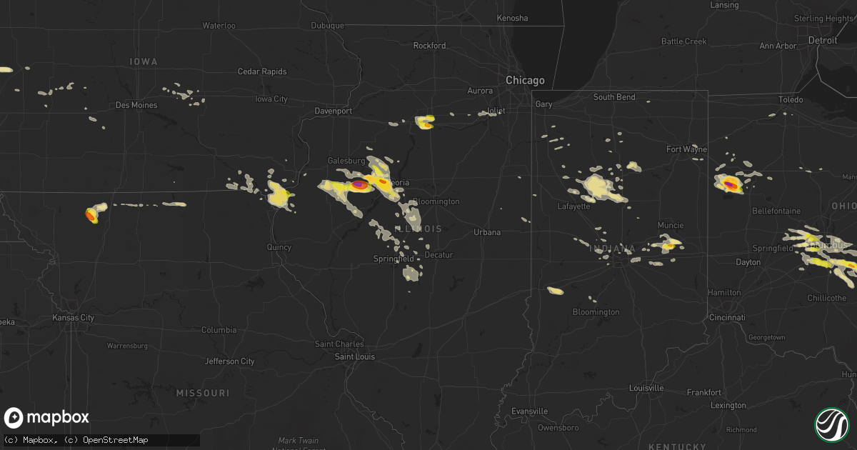
Hail Map in Illinois on July 10, 2017
Get this storm
July 10 map
$229
one time, instant access
Download today. No call, no setup
Keep the $229
Bought the map and want the full workflow? Apply the entire $229 to a subscription within 7 days. None of it is wasted.
Every map, not just this one
This buys you this map. Subscription and you get every map we run, in the markets you choose from a few cities to whole states to nationwide. Plus real-time alerts the moment a storm fires.
Contact data
Name, contact info, occupancy, even credit band for addresses in the footprint. You go from where it hit to who to call.
Become the source they trust
Unlimited branding weather history reports on demand. You already have the documented answer ready for the property owner, and you are the one who showed up with it.
Property data and RoofTrace estimates
Pull up any address you have got, its value and the exact code rules for that jurisdiction, straight from One Click Code. Then RoofTrace estimates the squares, pitch, and roof value, priced the way you price.
Storm reports in Illinois
Illinois
| Date | Description |
|---|---|
| 07/10/20176:57 PM CDT | A local report indicates 70 MPH wind near HANNA CITY |
| 07/10/20176:54 PM CDT | A local report indicates 1.75 inch wind near HANNA CITY |
| 07/10/20176:38 PM CDT | A local report indicates 1.00 inch wind near 3 SE BRIMFIELD |
| 07/10/20176:21 PM CDT | A local report indicates 1.00 inch wind near BRIMFIELD |
| 07/10/20175:42 PM CDT | Briefly touched down in field. Large rotating wall cloud becoming rain wrapped. Corrected time. |
| 07/10/20178:15 AM CDT | Numerous tree limbs and branches blown down. Power outage from 830 pm through 7 am tuesday morning. |
| 07/09/201710:55 PM CDT | *** 1 inj *** the severely damaged sructure mentioned in a previous lsr was a trailer. The injury occurred at the trailer due to wind damage. Numerous trees and power l |
| 07/09/201710:55 PM CDT | *** 1 inj *** house was severely damaged. Trees and power lines downed. |
| 07/09/201710:40 PM CDT | Trees blown down on several properties in rosamond. An awning blown down. |
| 07/09/201710:30 PM CDT | Large tree branch blown down on a garage. Numerous tree limbs blown down in yard. |
| 07/09/201710:25 PM CDT | 4 inch diameter tree limb blown down |
| 07/09/201710:04 PM CDT | Power lines down |
| 07/09/201710:00 PM CDT | 4-5 inch limbs off trees in flaggland subdivision...one tree uprooted in georgetowne subdivision on williamsburg street. |
| 07/09/20178:52 PM CDT | Quarter size hail near i-39 at exit 66. |
| 07/09/20178:45 PM CDT | Quarter size hail on i-39 near exit 57. |
| 07/09/20178:37 PM CDT | Ping pong ball size hail near shooting park road. |
| 07/09/20178:35 PM CDT | A local report indicates 59 MPH wind near 2 E LINCOLN |
| 07/09/20178:35 PM CDT | Time and location estimated by radar. |
| 07/09/20178:23 PM CDT | Several power lines down... One large tree down... One large antique windmill blown down. Time estimated based on radar. |
| 07/09/20178:15 PM CDT | Several trees down and two cars damaged from falling trees |
| 07/09/20178:14 PM CDT | At wfo ilx |
| 07/09/20178:14 PM CDT | Numerous power lines and poles down in town |
| 07/09/20178:10 PM CDT | Two 15-20 inch diameter trees snapped on 400 block of 10th street... Blocking road |
| 07/09/20178:09 PM CDT | Trees and power poles down in bushnell... Time estimated based on radar. |
| 07/09/20178:01 PM CDT | 2 foot diameter tree fell on car |
| 07/09/20177:27 PM CDT | A local report indicates 1.75 inch wind near 2 WSW FARMINGTON |
| 07/09/20177:23 PM CDT | A local report indicates 1.00 inch wind near PEKIN |
| 07/09/20177:23 PM CDT | Trees uprooted. Time estimated. |
| 07/09/20177:20 PM CDT | Relayed by ema |
| 07/09/20177:20 PM CDT | Relayed by ema. Time estimated. |
| 07/09/20177:15 PM CDT | A local report indicates 1.50 inch wind near 5 E LONDON MILLS |
| 07/09/20177:09 PM CDT | A local report indicates 1.00 inch wind near 3 S HANNA CITY |
| 07/09/20177:02 PM CDT | A local report indicates 1.00 inch wind near 4 E HANNA CITY |
All States Impacted by Hail Map on July 10, 2017
Cities Impacted by Hail Map on July 10, 2017
- Plain City, OH
- Milford Center, OH
- Mechanicsburg, OH
- West Jefferson, OH
- Galloway, OH
- Columbus, OH
- London, OH
- Grove City, OH
- Irwin, OH
- Hilliard, OH
- Woodstock, OH
- Garrison, MT
- Camp Crook, SD
- La Salle, IL
- Utica, IL
- Peru, IL
- North Port, FL
- Elgin, NE
- Twin Bridges, MT
- Wesley Chapel, FL
- Medina, OH
- Wadsworth, OH
- Zolfo Springs, FL
- Arcadia, FL
- Ewing, NE
- Bartlett, NE
- Petersburg, NE
- Ericson, NE
- Spalding, NE
- Anselmo, NE
- Nye, MT
- McLeod, MT
- Cassatt, SC
- Montpelier, ID
- Shannon, NC
- Lumber Bridge, NC
- Donnellson, IA
- West Point, IA
- Saint Paul, IA
- Livingston, MT
- New Castle, IN
- Middletown, IN
- Twelve Mile, IN
- Macy, IN
- Denver, IN
- Peru, IN
- Albany, MO
- Anaconda, MT
- Unionville, MO
- Ridgeway, MO
- Martinsville, MO
- Venedocia, OH
- Rockford, OH
- Celina, OH
- Mendon, OH
- Saint Marys, OH
- Spencerville, OH
- Cairo, GA
- Greycliff, MT
- Fort Wayne, IN
- New Haven, IN
- Silver Star, MT
- Amanda, OH
- Stoutsville, OH
- Circleville, OH
- Gold Creek, MT
- Greenfield, IN
- Fortville, IN
- Bradenton, FL
- Kahoka, MO
- Farmington, IA
- Dillon, MT
- Glen, MT
- Conrad, MT
- Bringhurst, IN
- Delphi, IN
- Riverton, IL
- Sherman, IL
- Grassy Butte, ND
- Ute, IA
- Dow City, IA
- Onawa, IA
- Soldier, IA
- Charter Oak, IA
- Denison, IA
- Hoskins, NE
- Stanton, NE
- Tilden, NE
- Oakdale, NE
- Wayne, NE
- Winside, NE
- Meadow Grove, NE
- Battle Creek, NE
- Norfolk, NE
- Pilger, NE
- Wisner, NE
- Centerpoint, IN
- Cory, IN
- Terre Haute, IN
- Brazil, IN
- Elmwood, IL
- Glasford, IL
- Hanna City, IL
- Trivoli, IL
- Mapleton, IL
- Peoria, IL
- Spring Valley, IL
- Dalzell, IL
- Lancaster, OH
- Hartsburg, IL
- Emden, IL
- Atlanta, IL
- Lincoln, IL
- Ohio City, OH
- Wapakoneta, OH
- Divide, MT
- Whitehall, MT
- Lambert, MT
- Akron, OH
- Vienna, WV
- Parkersburg, WV
- Williamstown, WV
- Upper Sandusky, OH
- Buffalo, SD
- Tippecanoe, IN
- Bourbon, IN
- Argos, IN
- Dade City, FL
- Daleville, IN
- Peninsula, OH
- Richfield, OH
- Pekin, IL
- Gosport, IN
- Bloomington, IN
- Eagleville, MO
- Indianapolis, IN
- Brownsburg, IN
- West Point, NE
- Bancroft, NE
- Beemer, NE
- Ovid, CO
- Burwell, NE
- Edinburg, IL
- Tovey, IL
- Bulpitt, IL
- Rochester, IL
- Taylorville, IL
- Kincaid, IL
- Pawnee, IL
- Morrisonville, IL
- Douds, IA
- Keosauqua, IA
- Birmingham, IA
- Sula, MT
- Philipsburg, MT
- Howells, NE
- Dodge, NE
- Bonaparte, IA
- Hinsdale, MT
- Lewistown, IL
- Ipava, IL
- Grace, ID
- Stonington, IL
- Blue Mound, IL
- Mount Sterling, OH
- Ashville, OH
- Orient, OH
- Arlington, IL
- Cherry, IL
- Carmel, IN
- Arnegard, ND
- Audubon, IA
- Pendleton, IN
- Wilkinson, IN
- Markleville, IN
- Grover Hill, OH
- Haviland, OH
- Brookston, IN
- Battle Ground, IN
- Palatka, FL
- Snellville, GA
- Pataskala, OH
- Reynoldsburg, OH
- Blacklick, OH
- Logansport, IN
- Jacksonville, FL
- Denver, MO
- Grinnell, IA
- Searsboro, IA
- Fort Madison, IA
- Niota, IL
- Keokuk, IA
- Argyle, IA
- Montrose, IA
- Hamilton, IL
- Nauvoo, IL
- Avon, MT
- Hall, MT
- Galata, MT
- Easton, IL
- Havana, IL
- Greenview, IL
- Athens, IL
- Petersburg, IL
- Kilbourne, IL
- Williamsville, IL
- Mason City, IL
- Elkhart, IL
- Whitlash, MT
- Luckey, OH
- Perrysburg, OH
- Yates City, IL
- Laura, IL
- Edwards, IL
- Tremont, IL
- Dunlap, IL
- Farmington, IL
- Princeville, IL
- Maquon, IL
- Canton, IL
- South Pekin, IL
- Brimfield, IL
- Bethany, MO
- New London, IA
- Rockbridge, OH
- Laurelville, OH
- Rochester, IN
- Monon, IN
- Rensselaer, IN
- Fort Jennings, OH
- Columbus Grove, OH
- Vaughnsville, OH
- Bowman, ND
- Eustis, FL
- Deland, FL
- Marysville, MT
- Avon, IL
- Walton, IN
- Havre, MT
- Princeton, MO
- Bassett, NE
- Taylor, NE
- Oakford, IL
- Glasgow, MT
- Green Pond, SC
- Zephyrhills, FL
- Nashua, MT
- Scribner, NE
- Columbus, ND
- Wabash, IN
- Roann, IN
- Logan, OH
- New Straitsville, OH
- Tampa, FL
- Augusta, GA
- Carman, IL
- Stronghurst, IL
- Fairview, IL
- London Mills, IL
- Ellisville, IL
- Julesburg, CO
- Moorhead, IA
- Castana, IA
- Delavan, IL
- San Jose, IL
- Green Valley, IL
- Newark, OH
- Goshen, IN
- Middlebury, IN
- Effingham, SC
- Pamplico, SC
- Cainsville, MO
- Oilmont, MT
- Sunburst, MT
- Carlton, GA
- Wheatfield, IN
- Butte, MT
- Pollock, MO
- Green Castle, MO
- Demotte, IN
- Chappell, NE
- Lodgepole, NE
- Sidney, NE
- Good Hope, IL
- Roseville, IL
- Monroeville, AL
- Nelsonville, OH
- Murray City, OH
- Amesville, OH
- Athens, OH
- Bremen, OH
- Junction City, OH
- Glouster, OH
- Canal Winchester, OH
- Millfield, OH
- Sugar Grove, OH
- Carroll, OH
- Leesburg, FL
- Tavares, FL
- Tallahassee, FL
- San Mateo, FL
- Mooreland, IN
- Elyria, NE
- Gallatin Gateway, MT
- Interlachen, FL
- Hawthorne, FL
- Chambers, NE
- Hagerstown, IN
- Ellettsville, IN
- Newton, IA
- Kellogg, IA
- Sells, AZ
- Jackson, MT
- Moccasin, MT
- Panama, IA
- Earling, IA
- Little River, AL
- Big Springs, NE
- Ambia, IN
- Fowler, IN
- Rhame, ND
- Hemingford, NE
- Bismarck, IL
- Apollo Beach, FL
- Burnettsville, IN
- Galveston, IN
- Kokomo, IN
- Young America, IN
- Flora, IN
- Idaville, IN
- Camden, IN
- Cut Bank, MT
- Kevin, MT
- Harrison, MT
- Ryegate, MT
- Ocilla, GA
- Waverly, WV
- Belpre, OH
- Harrison, NE
- Pierce, NE
- Racine, OH
- Lebanon, IN
- Baxter, IA
- Mingo, IA
- Mullen, NE
- Shorewood, IL
- Channahon, IL
- Minooka, IL
- Joliet, IL
- Elwood, IL
- Willshire, OH
- Van Wert, OH
- Sheffield, IL
- Princeton, IL
- Wyanet, IL
- Buda, IL
- Cardwell, MT
- Pierson, FL
- Lutz, FL
- Odessa, FL
- Deer Lodge, MT
- Ladd, IL
- La Moille, IL
- Seatonville, IL
- Mendota, IL
- Malden, IL
- Granville, IL
- New Palestine, IN
- Bozeman, MT
- Broken Bow, NE
- Lewistown, MT
- Scranton, ND
- Noonan, ND
- Shiloh, OH
- Greenwich, OH
- Newtown, MO
- Sharpsville, IN
- Windfall, IN
- Astor, FL
- Lafayette, IN
- Rossville, IN
- Cutler, IN
- Carthage, IN
- New Lenox, IL
- Danville, IN
- Homerville, OH
- Seville, OH
- Lodi, OH
- Merna, NE
- Melrose, FL
- Culver, IN
- Hays, MT
- Harlem, MT
- Chinook, MT
- Hogeland, MT
- New Holland, IL
- Wever, IA
- Kissimmee, FL
- Pulaski, IA
- Cantril, IA
- Milton, IA
- Smithfield, IL
- Land O'Lakes, FL
- Sedgwick, CO
- Judith Gap, MT
- Harrod, OH
- Alger, OH
- Ada, OH
- Buffalo, IL
- New Hampton, MO
- Gentry, MO
- Paisley, FL
- Waterville, OH
- Grand Rapids, OH
- Whitehouse, OH
- Mineral Wells, WV
- Amidon, ND
- Uriah, AL
- Thomasville, GA
- Frisco City, AL
- Atmore, AL
- Keystone Heights, FL
- Valier, MT
- Georgetown, ID
- Myakka City, FL
- Guysville, OH
- Baltimore, OH
- South Bloomingville, OH
- Pickerington, OH
- Urbana, OH
- Commercial Point, OH
- Pleasantville, OH
- Dublin, OH
- Lockbourne, OH
- Hebron, OH
- Jacksonville, OH
- Shawnee, OH
- Groveport, OH
- Thurston, OH
- Kirkersville, OH
- Millersport, OH
- Etna, OH
- Cable, OH
- New Albany, OH
- Abingdon, IL
- Gilson, IL
- San Antonio, FL
- Illiopolis, IL
- Cutler, OH
- Arlington, IN
- Bushnell, IL
- Smithshire, IL
- Sciota, IL
- Norris, IL
- Macomb, IL
- Prairie City, IL
- Table Grove, IL
- Marietta, IL
- Raritan, IL
- McBain, MI
- Mount Pleasant, IA
- Salem, IA
- Brule, NE
- Monmouth, IL
- Saint Augustine, IL
- Victoria, IL
- Kingston Mines, IL
- Manito, IL
- East Peoria, IL
- Toulon, IL
- Morton, IL
- Cameron, IL
- Groveland, IL
- Galesburg, IL
- Williamsfield, IL
- Lima, OH
- Hollywood, SC
- Elba, AL
- Sidney, MT
- Scranton, SC
- Lake City, SC
- Cecil, OH
- Serena, IL
- Luray, MO
- Mount Sterling, IA
- Sullivan, OH
- Bowling Green, OH
- Irwin, IA
- Powers Lake, ND
- Belle Fourche, SD
- Sumter, SC
- Bunker Hill, IN
- Corning, OH
- Somerset, OH
- New Lexington, OH
- Rushville, OH
- New Plymouth, OH
- Chillicothe, IL
- Stuart, IA
- Dexter, IA
- Dallas City, IL
- Warsaw, IL
- Basco, IL
- Satsuma, FL
- Saint Augustine, FL
- Elkton, FL
- Wharton, OH
- Malcom, IA
- Montezuma, IA
- Center Hill, FL
- Webster, FL
- Spencer, OH
- Wellington, OH
- Royal Center, IN
- Delphos, OH
- Green Cove Springs, FL
- Morris, IL
- Newark, IL
- Avon, IN
- Crawfordsville, IN
- New Ross, IN
- Jamestown, IN
- Camden, SC
- Shirley, IN
- Knightstown, IN
- Muncie, IN
- Springport, IN
- Monroeville, IN
- Hoagland, IN
- Ocala, FL
- Carthage, IL
- Lamar, SC
- Helmville, MT
- Wayland, MO
- Revere, MO
- Lignite, ND
- Menlo, IA
- Hebron, IN
- Plainfield, IN
- Sutherland, NE
- Wray, GA
- Three Forks, MT
- Pomeroy, OH
- Pittsboro, IN
- Lizton, IN
- Pinewood, SC
- Middle Point, OH
- Parrish, FL
- Sahuarita, AZ
- Whitestown, IN
- Arthur, NE
- Little Sioux, IA
- Shawmut, MT
- Mount Auburn, IL
- Edelstein, IL
- Speer, IL
- La Fayette, IL
- Galva, IL
- Altona, IL
- Reynolds, IN
- Wolcott, IN
- Centerville, IA
- Marysville, OH
- Big Timber, MT
- McAllister, MT
- Greensboro, GA
- Johnstown, NE
- Soda Springs, ID
- Brewton, AL
- Elwood, IN
- Burlington, IN
- Monticello, IN
- Yeoman, IN
- Russiaville, IN
- Coon Rapids, IA
- Lowell, IN
- Canyon Creek, MT
- Lincoln, MT
- Malta, MT
- Hobson, MT
- Coward, SC
- Alexander, ND
- Sheridan, MT
- Pender, NE
- Emigrant, MT
- Citra, FL
- Marsland, NE
- Exira, IA
- Hephzibah, GA
- Blythe, GA
- Colquitt, GA
- Lewisville, IN
- Falmouth, IN
- Winterset, IA
- Warrensburg, IL
- Lucerne, MO
- Springfield, IL
- Bayard, IA
- Watseka, IL
- Danville, IL
- Alvin, IL
- Lava Hot Springs, ID
- Gifford, IL
- Harrisburg, OH
- Conner, MT
- Seffner, FL
- Gibsonton, FL
- Riverview, FL
- Thorntown, IN
- Kirklin, IN
- Minier, IL
- Armington, IL
- Beason, IL
- Mackinaw, IL
- Hopedale, IL
- McLean, IL
- Lawndale, IL
- Cuyahoga Falls, OH
- Hinckley, OH
- Hudson, OH
- Maxbass, ND
- Glenburn, ND
- New London, OH
- Tekamah, NE
- Bucyrus, OH
- Nevada, OH
- Paxton, NE
- Bloomingburg, OH
- Mount Pulaski, IL
- Chestnut, IL
- Thonotosassa, FL
- Yale, IA
- East Palatka, FL
- Lyons, NE
- Troy Grove, IL
- New England, ND
- Edgemont, SD
- Lance Creek, WY
- Trimble, OH
- Alma, WV
- Middlebourne, WV


