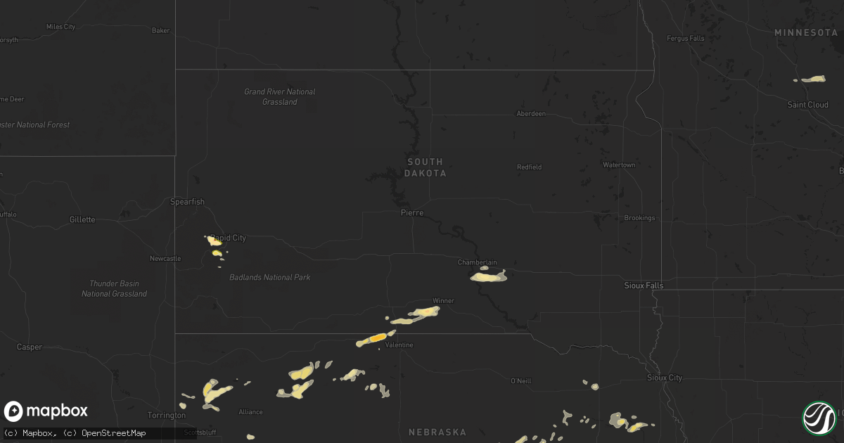
Hail Map in South Dakota on July 10, 2014
Get this storm
July 10 map
$229
one time, instant access
Download today. No call, no setup
Keep the $229
Bought the map and want the full workflow? Apply the entire $229 to a subscription within 7 days. None of it is wasted.
Every map, not just this one
This buys you this map. Subscription and you get every map we run, in the markets you choose from a few cities to whole states to nationwide. Plus real-time alerts the moment a storm fires.
Contact data
Name, contact info, occupancy, even credit band for addresses in the footprint. You go from where it hit to who to call.
Become the source they trust
Unlimited branding weather history reports on demand. You already have the documented answer ready for the property owner, and you are the one who showed up with it.
Property data and RoofTrace estimates
Pull up any address you have got, its value and the exact code rules for that jurisdiction, straight from One Click Code. Then RoofTrace estimates the squares, pitch, and roof value, priced the way you price.
Storm reports in South Dakota
South Dakota
| Date | Description |
|---|---|
| 07/10/20144:37 PM CDT | A local report indicates 1.00 inch wind near 10 WNW FAIRBURN |
| 07/10/20143:08 PM CDT | A local report indicates 1.50 inch wind near HISEGA |
| 07/10/20143:00 PM CDT | A local report indicates 1.75 inch wind near 2 SE PACTOLA RESERVOIR |
| 07/10/20143:00 PM CDT | A local report indicates 1.00 inch wind near JOHNSON SIDING |
| 07/09/201411:00 PM CDT | A local report indicates 62 MPH wind near 4 SSE WITTEN |
| 07/09/201410:30 PM CDT | A local report indicates 60 MPH wind near 12 SSE OKREEK |
| 07/09/201410:22 PM CDT | Large tree branches broken off. Mailbox post pushed over. |
| 07/09/201410:10 PM CDT | Magpie creek raws |
All States Impacted by Hail Map on July 10, 2014
Cities Impacted by Hail Map on July 10, 2014
- Kinta, OK
- Beryl, UT
- Bingham, NE
- Duncannon, PA
- Havre, MT
- Kilgore, NE
- Crookston, NE
- Pine Grove Mills, PA
- State College, PA
- Petersburg, PA
- Huntingdon, PA
- Pennsylvania Furnace, PA
- Zebulon, NC
- Middlesex, NC
- Norfolk, VA
- Portsmouth, VA
- Clayton, NC
- Gresham, SC
- Angora, NE
- Emporia, VA
- Drewryville, VA
- Chesapeake, VA
- Lignite, ND
- Babb, MT
- Scotia, NE
- Ericson, NE
- Stanton, NE
- Pilger, NE
- Purvis, MS
- Bladenboro, NC
- Chinook, MT
- Suffolk, VA
- Rapid City, SD
- Keystone, SD
- Souris, ND
- Merriman, NE
- Ashby, NE
- Ellsworth, NE
- Roxobel, NC
- Scotland Neck, NC
- Rich Square, NC
- Richton, MS
- Wilburton, OK
- Tuskahoma, OK
- Guyton, GA
- Columbus, ND
- Wendell, NC
- Lloyd, MT
- Gurley, NE
- Carrsville, VA
- Franklin, VA
- Fontanelle, IA
- Bridgewater, IA
- Braithwaite, LA
- Cody, NE
- Harrison, NE
- Red Springs, NC
- Maxton, NC
- Shannon, NC
- Alliance, NE
- Windsor, NC
- Conway, SC
- Loris, SC
- Taylors, SC
- Greer, SC
- Galata, MT
- Chamberlain, SD
- Pukwana, SD
- Beemer, NE
- Thedford, NE
- Naples, FL
- Mclean, NE
- Marsland, NE
- Virginia Beach, VA
- Dover, AR
- Russellville, AR
- Latta, SC
- Bartlett, NE
- Spalding, NE
- Zuni, VA
- Windsor, VA
- Newsoms, VA
- Sedley, VA
- Courtland, VA
- Skippers, VA
- Capron, VA
- Boykins, VA
- Ozark, AR
- Kramer, ND
- Winner, SD
- Fort Peck, MT
- Malta, MT
- Perryville, AR
- Como, NC
- Pembroke, GA
- Winterville, NC
- Greenville, NC
- Hays, MT
- Dodson, MT
- Oshkosh, NE
- Lisco, NE
- Ord, NE
- Zortman, MT
- Dalton, NE
- Broadwater, NE
- Lodgepole, NE
- Lewellen, NE
- Mount Gilead, NC
- Lilesville, NC
- Harlem, MT
- Elizabethtown, NC
- Clarkton, NC
- Rice, MN
- Royalton, MN
- Pierz, MN
- Foley, MN
- Hemingford, NE
- Lake Placid, FL
- Mission, SD
- Stennis Space Center, MS
- Gordon, NE
- Tillar, AR
- Aynor, SC
- Galivants Ferry, SC
- Sanford, NC
- Moncure, NC
- Albion, NE
- Petersburg, NE
- Nenzel, NE
- Hillman, MN
- Powers Lake, ND
- Saint Francis, SD
- Robersonville, NC
- Williamston, NC
- Gildford, MT
- Box Elder, MT
- Big Sandy, MT
- Bridgeport, NE
- Valentine, NE
- Wisner, NE
- Moorhead, IA
- Tryon, NE
- Bowlus, MN
- Stantonsburg, NC
- Snow Hill, NC
- Saint Pauls, NC
- Hingham, MT
- Plant City, FL
- Louisburg, NC
- Kelford, NC
- Lewiston Woodville, NC
- Platte, SD
- Powells Point, NC
- West Point, NE
- Bancroft, NE
- Selma, NC
- Kenly, NC
- Kimball, NE
- Kimball, SD
- Mullins, SC
- Hershey, PA
- Garner, NC
- Smithfield, NC
- Raleigh, NC
- Pine Bluff, AR
- Grady, AR
- Ridgeville, SC
- Elizabeth City, NC
- Camden, NC
- Neligh, NE
- Tilden, NE
- Elgin, NE
- Oakdale, NE
- Paris, AR
- Subiaco, AR
- Bottineau, ND
- Princeton, NC
- Hortense, GA
- Green Sea, SC
- Nichols, SC
- Hermosa, SD
- Skiatook, OK
- Hattiesburg, MS
- Wausa, NE
- Osmond, NE
- Columbia, NC
- Tallulah, LA
- Brooklet, GA
- Benson, NC
- Coats, NC
- Angier, NC
- Meadow Grove, NE
- Corning, IA
- Lumberton, MS
- Franklinton, NC
- Shelby, MT
- Oilmont, MT
- Saint Bernard, LA
- Anguilla, MS
- Granville, ND
- England, AR
- Fort Stewart, GA
- Pinola, MS
- Newhebron, MS
- Lecanto, FL
- Beverly Hills, FL
- Meadview, AZ
- Hinsdale, MT
- Arnold, NE
- Hertford, NC
- Chester, MT
- Evergreen, NC
- Chadbourn, NC
- Norfolk, NE
- Madison, NE
- Holly Springs, NC
- Apex, NC
- New Hill, NC
- Seligman, AZ
- Whitakers, NC
- Walstonburg, NC
- Kevin, MT
- Newton Grove, NC
- Mount Olive, NC
- Sumter, SC
- Wedgefield, SC
- Pikeville, NC
- Goldsboro, NC
- La Grange, NC
- Burwell, NE
- Halifax, NC
- Townsend, GA
- Yoder, WY
- Kinston, NC
- Rosston, AR
- Lithia, FL
- Gregory, SD
- Lucama, NC
- Battle Creek, NE
- Harrisburg, NE
- Branchville, VA
- Wadesboro, NC
- Marion, SC
- Hollandale, MS
- Chatham, MS
- Lyman, SC


