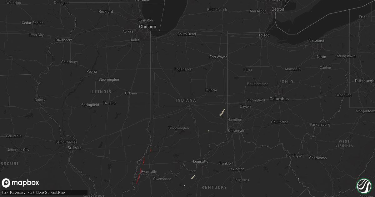
Hail Map in Indiana on July 9, 2024
Get this storm
July 9 map
$229
one time, instant access
Download today. No call, no setup
Keep the $229
Bought the map and want the full workflow? Apply the entire $229 to a subscription within 7 days. None of it is wasted.
Every map, not just this one
This buys you this map. Subscription and you get every map we run, in the markets you choose from a few cities to whole states to nationwide. Plus real-time alerts the moment a storm fires.
Contact data
Name, contact info, occupancy, even credit band for addresses in the footprint. You go from where it hit to who to call.
Become the source they trust
Unlimited branding weather history reports on demand. You already have the documented answer ready for the property owner, and you are the one who showed up with it.
Property data and RoofTrace estimates
Pull up any address you have got, its value and the exact code rules for that jurisdiction, straight from One Click Code. Then RoofTrace estimates the squares, pitch, and roof value, priced the way you price.
Storm reports in Indiana
Indiana
| Date | Description |
|---|---|
| 07/09/20246:21 PM CDT | Brief... Weak ef-0 tornado. Small trees and larger tree limbs down were the only damage reported. |
| 07/09/20245:50 PM CDT | An ef-1 touched down 0.8 miles west southwest of patoka and lifted 1.1 miles northwest of patoka. The estimated peak wind was 100 mph. The path length was 1.06 miles an |
| 07/09/20245:15 PM CDT | Report from mping: trees uprooted or snapped; roof blown off. |
| 07/09/20244:51 PM CDT | An ef-2 tornado touched down 0.7 miles north of poseyville and lifted 1.3 miles north of johnson in gibson county. The estimated peak wind was 120 mph. The path length |
| 07/09/20244:40 PM CDT | Confirmed tornado on the ground. |
| 07/09/20244:32 PM CDT | An ef-1 tornado touched down 0.4 miles east of springfield and lifted 4.6 miles west southwest of wadesville in posey county. The estimated peak wind was 105 mph. The p |
| 07/09/20244:25 PM CDT | Pole barn knocked completely down. |
| 07/09/20244:21 PM CDT | Power outage reported. |
| 07/09/20244:18 PM CDT | An ef-3 tornado touched down 2 miles east of mt vernon and lifted 2.4 miles east southeast of solitude in posey county. The estimated peak wind was 140 mph. The path le |
| 07/09/20246:10 AM CDT | Time estimated via radar. Tree down at cr 450 e and cr 200 n. |
| 07/09/20245:54 AM CDT | Tree down on us 24. Time estimated via radar. |
| 07/09/20245:49 AM CDT | Report of a tree down at us 35 and cr 100 n. Time estimated via radar. |
| 07/08/20247:00 PM CDT | Trees reported down on townsend road. |
All States Impacted by Hail Map on July 9, 2024
Cities Impacted by Hail Map on July 9, 2024
- Barksdale, TX
- Rocksprings, TX
- Brackettville, TX
- Sonora, TX
- Sand Lake, NY
- Averill Park, NY
- Uvalde, TX
- Tompkinsville, KY
- Burkesville, KY
- Summer Shade, KY
- Edmonton, KY
- Breeding, KY
- Belgrade, ME
- Oakland, ME
- Cimarron, NM
- Morganfield, KY
- Sonoita, AZ
- Springer, NM
- Uniontown, KY
- Mount Vernon, IN
- Elgin, AZ
- Ute Park, NM
- Burlington, ME
- Glen Gardner, NJ
- Clinton, NJ
- Augusta, ME
- Manchester, ME
- Gardiner, ME
- Readfield, ME
- Winthrop, ME
- Hampton, NJ
- Hereford, AZ
- Patagonia, AZ
- Leitchfield, KY
- Lee, ME
- Dryden, TX
- Hallowell, ME
- Farmingdale, ME
- Monmouth, ME
- Randolph, ME
- New Braunfels, TX
- Seguin, TX
- New Harmony, IN
- Wadesville, IN
- Raton, NM
- Magdalena, NM
- Whitefield, ME
- Hudson, KY
- Springfield, ME
- San Acacia, NM
- Polvadera, NM
- Lemitar, NM
- Milaca, MN
- Poseyville, IN
- Owensville, IN
- Foreston, MN
- Wagon Mound, NM
- Socorro, NM
- Mimbres, NM
- Hanover, NM
- Colebrook, CT
- Vaughn, NM
- Barkhamsted, CT
- Riverton, CT
- Winsted, CT
- Truth Or Consequences, NM
- Erving, MA
- Orange, MA
- Wendell Depot, MA
- Wendell, MA
- Bisbee, AZ
- Millers Falls, MA
- Gill, MA
- Turners Falls, MA
- Northfield, MA
- Roy, NM
- New Salem, MA
- Montague, MA
- Warwick, MA
- Athol, MA
- Petersham, MA
- Templeton, MA
- Barre, MA
- Vine Grove, KY
- Rineyville, KY
- Orient, ME
- Ocate, NM
- Ellendale, ND
- Vincennes, IN
- Hubbardston, MA
- Saint Libory, NE
- Radcliff, KY
- Frederick, SD
- Williamsburg, NM
- Grand Island, NE
- Jud, ND
- Doniphan, NE
- Phillips, NE
- Trementina, NM
- Giltner, NE
- Gackle, ND
- Butlerville, IN
- Lenore, WV
- Williamson, WV
- Kermit, WV
- Lovely, KY
- Las Cruces, NM
- Conchas Dam, NM
- Breeden, WV
- Dingess, WV
- Connersville, IN
- Brookville, IN
- Columbia, SD
- Laurel, IN
- Liberty, IN
- West Hartland, CT
- Hecla, SD
- Eaton, OH
- San Ygnacio, TX
- Litchville, ND
- Marion, ND
- Kathryn, ND
- Fort Ransom, ND
- Houghton, SD
- Zapata, TX
- Warner, SD
- Mellette, SD
- Mansfield, SD
- Aberdeen, SD
- Claremont, SD
- Langford, SD
- Andover, SD
- Pierpont, SD
- Summit, SD
- Ortley, SD
- Hamlin, NY


